
Cite this as: Aryankhesal, F.F. 2023 'HS2 Phase One: Heritage GIS Digital Archive (Data paper)', Internet Archaeology, HS2 publications. https://doi.org/10.11141/ia.hs2.1
The data archive has been deposited with the Archaeology Data Service.
HS2 Phase One: Heritage GIS Digital Archive: https://doi.org/10.5284/1113006
HS2 Phase One: Heritage GIS Digital Archive - Raster Data: https://doi.org/10.5284/1113005
Referee statement by Thomas Cromwell
High Speed Two (HS2) GIS data comprise both evaluation and mitigation spatial data from HS2 Phase One Historic Environment Programme.
For Archaeology Data Service (ADS) data deposition purposes, the HS2 Historic Environment GIS data has been divided into different GIS data packages, based on Area of Interests (AoI) along the line of the route. Each AoI is a 1km buffer around the boundary of a local authority.
According to the nature of historic environment surveys and activities data collection, there are five different GIS Schemas, each with their own datasets as follows:
Each GIS data package includes three folders:
HS2 prepare and send the GIS data packages to the ADS and line of route HERs (Historic Environment Records), every six months. The old revisions of data may then be superseded. The first GIS data deposited to ADS was transmitted in March 2021.
HS2's historic environment investigation programme is the largest ever undertaken in the UK, and it is revealing more than 10,000 years of British history, from prehistoric times through to World War Two. Phase One of High Speed Two (HS2) is being constructed using a hybrid Act 'High Speed Rail (London – West Midlands) Act 2017'. Accompanying the Act are the Environmental Minimum Requirements (EMRs), the overarching commitments by the Secretary of State to afford appropriate management and protection of people, communities and the natural, cultural and built environment (HS2 2017b). The Heritage Memorandum is one of the EMRs (HS2 2017c). It sets out how the historic environment will be addressed during the design and construction of Phase One of HS2.
To fulfil the commitment set out in the HS2 Heritage Memorandum, the Historic Environment Research and Delivery Strategy (HERDS) has been established for the fieldwork stage (HS2 2017d). HERDS sets out the project mechanisms for designing works, undertaking evaluation, delivering investigations, reporting, and archive deposition that will be adopted for the design and construction of Phase One of HS2. It presents a clear statement of objectives, standards and structure for the planning and implementation of historic environment works.
According to HERDS, a Building Information Management (BIM) approach and GIS are the key elements in the delivery of historic environment digital data, which enable:
There are 30 different investigation activities in the HS2 historic environment programme, for which the delivery of their relating GIS data by contractors is mandatory. These GIS data deliverables are submitted and stored through five different GIS schemas, according to the nature and content of the evaluation/mitigation surveys.
The principal components of the HERDS GIS data are defined according to historic environment assets. These assets form the principal structure of the data which enable hierarchies and relationships to be established.
The HS2 historic environment assets hierarchy comprises five assets classes (two core asset classes and three primary classes of assets) (Figure 1).
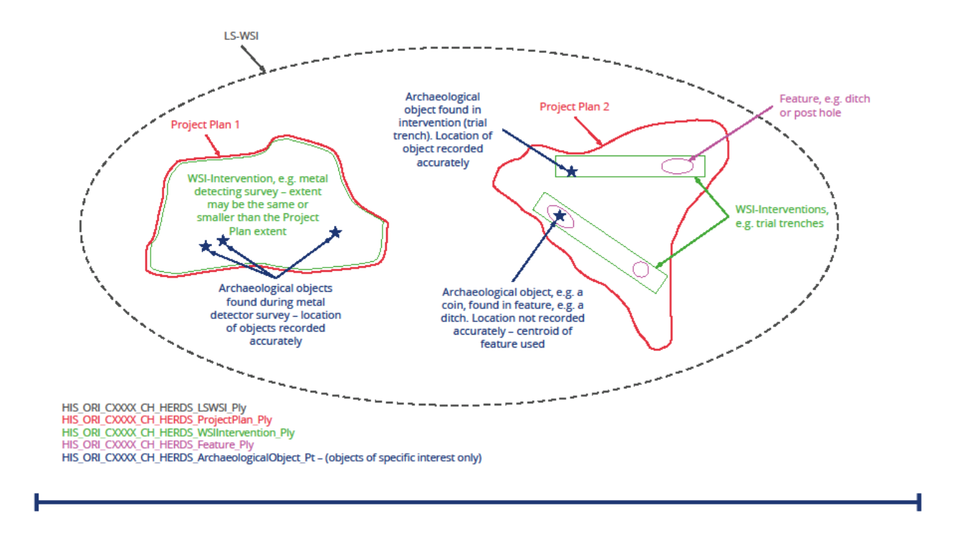
Aside from the above feature classes, the documents list and objective lists in gdb table formats have been deployed in HERDS GIS schemas, which enable linking GIS data to their relating reports (non-GIS data). Technically, reports and objectives of historic environment surveys and mitigations are all joined to their respective Project Plan polygon through a Project Plan's Unique Asset ID (UAID) field, which is a mutual attribute in those GIS layers. Also, 'Site Code' and 'HS2 Unique Asset ID (UAID)' as two crucial attributes embedded in the GIS datasets, play a significant role to create a relationship between HS2 historic environment GIS data and their associated physical and digital archive data.
The land required to be constructed in Phase One of HS2 along the route from London Euston to Birmingham and the West Midlands, is approximately 406 km² (40600 hectares) which is over 230 km (140 miles) long. The majority of the archaeological works were undertaken by the Enabling Works Contractors (EWCs) and their specialist supply chain. The route was divided into three areas for the enabling works – north, central, and south. Some archaeological works have been carried out by the Main Works Contractors (MWCs) and their specialist supply chain.
The line of route Local Authority Historic Environment Records (HERs) who were provided with the GIS data packages, according to their associated Areas of Interests (AoI), are listed in Table 1.
| 1 | Greater London |
| 2 | Buckinghamshire |
| 3 | Hertfordshire |
| 4 | Oxfordshire |
| 5 | Northamptonshire |
| 6 | Warwickshire and Solihull* |
| 7 | Birmingham |
| 8 | Staffordshire |
| 9 | Coventry |
| *Warwickshire HER oversees the HER in Solihull, therefore a single data package was created | |
The GIS data generated from HS2 Phase One Historic Environment works provides an invaluable resource for future researchers of all types. This includes:
The creation of HS2's historic environment physical and digital archive is an integral part of the lasting legacy of the programme. HS2 will provide access to the artefacts and information in a variety of interesting ways through both publications and accessible archive that will enable people to learn about the story of a nation.
Digital Archive
The HS2 Phase One contractors were required to submit all the digital data generated during the undertaking of the historic environment programme in different reports and data formats. This HS2 digital archive will be made available to the public. The digital elements of the archive, including GIS data, is curated by the ADS, being the primary accredited digital repository for archaeological archives within the UK. This approach is supported by Historic England (HE). Three categories of HS2 digital archive are transmitted to the ADS.
Physical Archive
The HS2 historic environment physical archive (the artefacts and analogue records) will, where possible, be deposited locally with line-of-route museums according to their geographical collecting areas.
I am grateful to the HS2 Historic Environment Team, particularly Helen Wass, HS2 Heritage Lead, and Dr. John Halsted, Senior Historic Environment Manager, for their invaluable guidance and support. Helen Wass's expertise and insightful feedback, as well as Dr. John Halsted's extensive experience, have greatly influenced the direction and quality of this paper. I also appreciate the collective efforts of the entire HS2 Historic Environment Team and the encouragement from Michael Court, HS2 Historic Environment Lead. Their contributions have been instrumental in making this project a success
Cite this as: Cromwell, T. 2023 'Referee statement' in Aryankhesal, F.F. 2023 'HS2 Phase One: Heritage GIS Digital Archive (Data paper)', Internet Archaeology HS2. https://doi.org.uk/10.11141/ia.hs2.1.ref
This dataset comprises a wide range of archaeological investigative techniques applied to the entire route of the HS2 train line from London to Birmingham (Phase One). The work includes geophysical surveys and other remote sensing, as well as more intrusive trial-trenching and open-area excavation. As such, it is a varied and complex dataset of great value.
At its core is the interactive map allowing access to the geophysical surveys and excavations, these latter prefaced with the research questions that set out the work. Copies of site reports can be found there, but access to site records including drawings, photos, and primary record sheets allows detailed examination not normally possible in published site reports alone. The geophysics comes as a range of GIS-compatible outputs based on a globally-defined set of metadata that enables cross-comparison.
The data harvested from HS2 offers an unprecedented slice through British archaeology, collected in one place in detail on a scale hitherto unknown. Not only can researchers examine the route at high level, they can also drill down to the individual site-created plans, photos, and record data allowing reinterpretation of the primary information. Even better, researchers can harvest elements of this raw data to aid targeted projects. It will be interesting to see how this wealth of new knowledge, available electronically, will affect the direction of British archaeology.
Internet Archaeology is an open access journal based in the Department of Archaeology, University of York. Except where otherwise noted, content from this work may be used under the terms of the Creative Commons Attribution 3.0 (CC BY) Unported licence, which permits unrestricted use, distribution, and reproduction in any medium, provided that attribution to the author(s), the title of the work, the Internet Archaeology journal and the relevant URL/DOI are given.
Terms and Conditions | Legal Statements | Privacy Policy | Cookies Policy | Citing Internet Archaeology
Internet Archaeology content is preserved for the long term with the Archaeology Data Service. Help sustain and support open access publication by donating to our Open Access Archaeology Fund.
 Home
Home