The demographic pressure suggested by the (admittedly sketchy) population data can be detected archaeologically, as can the vllazni to mehalla process of neighbourhood creation, when specific neighbourhoods are examined in detail. We have analysed this process in two Theth neighbourhoods, those of upper Gjelaj and Gjeçaj.
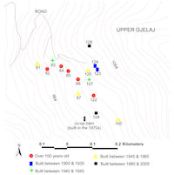
The Gjelaj neighbourhood lies high up on the eastern slopes of the valley, roughly midway between Ulaj and Okol (Fig. 2). Its fields, now terraced, would not have been ideal farmland originally, and it seems likely to have been a relative latecomer to Theth's neighbourhoods. Architectural analysis and village testimony confirmed this suspicion, identifying only five homes in upper Gjelaj as 'old': meaning undateable, but clearly preceding the 20th century (Fig. 23; this figure was generated from the 2005 structures layer of the SVP GIS and we encourage readers to produce their own maps using SVP structure data, such as construction dates, materials, structure function, location, etc. and inform us of any interesting patterns detected). The first three decades of the 20th century saw the creation of a free Albania, and a relatively successful effort by King Zog to end the blood feud. Then in 1936 the old horse road from Theth over the mountains to Boga and then Shkodra was enlarged to wagon width. These three things in combination created a burst of building activity in the village as a whole, especially in the 1930s. Houses built or renovated during and after that period increasingly lacked the defensive features required in the era of the blood feud, having larger windows and living quarters on the first floor (Hasluck 1954) (audio clip #4; Figs. 24 and 25). Gjelaj's 1930s expansion was modest, apparently just a pair of brothers who built adjoining houses here at the same time.
Figure 23: The houses of upper Theth Gjelaj, coded by the approximate date of their construction (outbuildings have been removed) (Lee and Galaty).
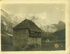
Figure 24: ST245 in Theth Kolaj. Photo by Pici, 1935.
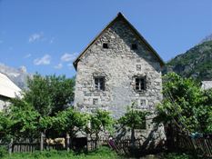
Figure 25: ST245 in Theth Kolaj, 2005. Note that frengji windows have been closed and large windows have been added.
Two more houses appeared during the 1940s, and then four more in the early post-war period as the Communist regime began to establish some control over the countryside, but had not yet imposed collectivisation in the northern mountains (local interviews, 2005; de Waal 1996; 2004; Baçi 1981; Baçi must be used with care, but in terms of the chronology of the process of collectivisation it is probably reliable). Explaining this relatively speedy expansion in the number of houses, however, returns us to the problem of what constitutes a 'house' and a 'household'. It is possible that some of the motivation behind this burst of home-building in the 1950s and 1960s lay in an anticipation of the collectivisation process, which expanded into the mountains only in the late 1960s (audio clip #5). During the Communist era the state preferred nuclear families, rather than having extended, so-called 'joint', families live together under one roof. Furthermore, the state inaugurated policies restricting private landholding to 1 or 2 'dynyms' of land per each family (also spelled 'dylym', it is equal to a 100 x 10m or .1ha parcel). This led many joint family households to divide prematurely (from their point of view) and build new houses in order to hold on to more land. (N.B. this pressure was attested by individual interviews, 2005. State-sponsored land reform immediately after the war redistributed land from the large landholders to their tenants, limiting individual owners to 5 ha (a process completed by 1946). This large 'limit' seems unlikely to have had any effect on the mountains. After 1968, as collectivisation took hold in the mountains the limits were tightened. Farmers in the mountains were allowed a limit of 0.1 ha irrigated land, or 0.15 unirrigated. Mountain farmers were allowed to keep one cow and ten sheep and goats (increased to 20 if they had joined a collective farm created after January 1, 1966). In addition they could have one pig, unlimited rabbits and hens, as well as one goose or up to fifteen turkeys. Beasts of burden were no longer permitted, which severely hampered moving personal goods to market. Statistics from Sjöberg 1991.)
It was also in this period that many single-storey homes expanded to a second storey, or, if already a two-storey building, the ground level was transformed from space for animals into living space for the family (see section 5.3.1.3, Fig. 27 in particular; Hecquard 1858). Note that these would seem to be contradictory trends: the expansion of both the home itself and a simultaneous expansion in the number of homes. Normally one might expect that the one should make the other unnecessary. But as suggested by the limited demographic data that we have, the Communist-era restriction on movement meant that the large number of male children now had to remain in the village, some of whom may formerly have emigrated elsewhere for work. (N.B. the mountain tribes are today exogamous, as they were under Communism, and women from Theth appear to marry into families further down the valley, in the villages of Gimaj, Bregu i Lumi, etc., and vice versa. Many of the women who married into Nen Mavriq and Dakaj (communities to the south of Theth surveyed in 2006) are from the region of Shosh, which is in turn yet further south.) Regional statistics clearly reflect the overall pressure on rural population. Annual growth rates in the neighbouring mountainous district of Tropojë (which, unlike Shala, was not administratively grouped with a large urban area) were fairly consistently high between 1950 and 1987, varying only from 2.2% to 2.7% (Sjöberg 1991). Few countries worldwide now have a comparable growth rate (The World Factbook2006). Communist restrictions on movement, although at least partly porous, were serious enough to see the average Albanian village population rise from 382 to 654 between 1955 and 1979 (Sjöberg 1991).
The next major burst of building activity, but not house building, occurred during the early to mid-1970s, and was probably a result of the continued tightening of access to private land, and the then-maturing system of collectivisation. Restriction on private landholding made it difficult to identify plots upon which to build new homes, but meanwhile the state's intervention in the mountains provided new truck-based transport of building materials (especially cement), and an expansion of the road network into the individual neighbourhoods (in theory the roads were intended to service the co-operative farming facilities). Although individuals were not allowed to own vehicles, state-owned trucks could bring in building supplies in service of the co-operative. The new roads and the process of collectivisation resulted in a massive expansion of built space within the village - not homes, but administrative buildings, co-operative structures, and state tourism facilities. From 1966 to 1980, no new homes appeared in Gjelaj.
The loosening of the regime's grip in the late 1980s and the early 1990s brought about the most recent burst of home building [View Comments]. The optimism and privatisation associated with that era may have spurred this burst of building (not to mention the built up demographic pressure), but the disaster of 1997 curtailed such efforts until the most recent couple of years. In Gjelaj itself, the 1980s saw two houses added, but the beginning of massive emigration (to Shkodra, Tirana, and abroad) in 1991 has discouraged further home building this far up the mountain.
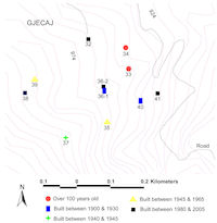
Figure 26: The houses of Theth Gjeçaj, coded by the approximate date of their construction (outbuildings have been removed) (Lee and Galaty).
This basic pattern of neighbourhood expansion from a couple of key older houses, often built on former pasture, can be traced with even greater accuracy in Gjeçaj (Fig. 26). Two informants differ slightly on the details, but both agree that Structures 033 and 034 were the first in the neighbourhood, and were built roughly at the same time, around 1900. One informant suggests that they were built by his grandfather and his grandfather's brother at the same time. The two brothers moved to this location from the other side of the river, originally moving into an existing barn, and then building the two homes for the brothers' families to move into.
Architectural details are consistent with this story; both houses conform to our expectations for homes built approximately 100 years ago, and there is one other house in the area, ST040, that was probably built around the same period. Architectural characteristics of houses of this period include frengjis, the small stone-framed windows designed to provide a bare minimum of light and air, while still preventing an outsider from firing into the house (readers can see a number of examples by searching the structure database with keyword "frengji"). This feature tends to date a home to the period at least before 1950, and probably from before about 1930. While carved symbols on houses in the Shala valley are not necessarily chronologically determinative, there is a tendency for older houses to have a greater profusion of these carved on the lintels and cornerstones. (A database search for the keywords "symbol" and "carving" will bring up many examples, with drawings and photographs, of the rich variety of symbols depicted on the houses of Shala.)
From these three first homes the neighbourhood progressively expanded. The owner of ST040 built himself a new house in 1957 (ST035), possibly in anticipation of impending collectivisation, and then one for his son (ST041), probably in the 1980s. Both of the later houses were abandoned in 1995 when he moved to Shkodra. House 040 is now occupied, on a tenant basis, by one of the owner's cousins.
Houses 036-1 and 037 would seem to date to the 1930s, based on the lintel stone on 036-1, and the type of construction shared by both homes. Homes were still built with frengji windows into the 1930s, but as the danger of blood feud declined, frengjis were closed up or replaced with larger windows. The 'first generation' of replacement windows tended to resemble the earlier small windows, still framed with four large blocks of stone, but now with a much larger opening. We have no family histories for these homes, but the family in 036-1 clearly later needed to expand, and, probably in the 1970s or 80s, split the house in half, adding the appropriate additional outbuildings (see below for more on splitting homes).
House 039 was built in 1965 (thus in the same pre-collectivisation 'wave' as ST035), and two other homes were added on the edges of the neighbourhood, probably in the 1980s (ST038 and ST032, the latter firmly dated to 1986), joining ST041 and the splitting off of ST036-2. The use of a raised and slightly offset foundation, especially when done in combination with an inset porch, nearly always indicates construction in the 1980s, with some in the early 1990s. Early versions of the offset foundation can be detected in the 1970s. (Visual examples of the various architectural features observed can be found by browsing the Structures database, where period is indicated when known. Further discussion of the problems of architectural chronology in the Shala valley can be found in the reports of the 2005 and 2007 field seasons hosted on the SVP website at http://www.millsaps.edu/svp.)
Archived Comments
How do these changes in settlement pattern compare with other parts of Albania where collectivization was also enforced under Communism? The authors would be interested in observations from those working or living in other regions.