The fieldwork was conducted in April 2011 with two main objectives: to systematically characterise the plough-zone archaeology on a Barbadian plantation for the first time, and evaluate non-intrusive survey techniques (geophysical survey and fieldwalking which were untested on the island) with respect to both their suitability within the geological context of Barbados, and their usefulness for identifying the presence of enslaved and free workers within the archaeological record.
There has not been a systematic attempt to survey plantation archaeology on Barbados since Handler and Lange's work in the 1970s, which combined oral testimony, field names, fieldwalking and test pitting to try and identify the location of slave villages and cemetery sites on a number of plantations (Handler and Lange 1978; Lange and Carlson 1985). Since then Thomas Loftfield has published a number of articles on locally made earthenwares, and Frederick Smith has published on a number of sites, including urban sites and St Nicholas Abbey (Loftfield 1992; 2001; Smith 2004; Smith and Watson 2007; 2009), while Niall Finneran has recently published an account of his work in and around Speightstown, as a 'creole townscape' (Finneran in press). However, the fact that Newton remains the only known plantation slave cemetery on the island suggests that there is still an urgent need to characterise the nature of the archaeological resource, to enable the identification of important sites that can contribute to the island's narrative. Techniques that can be carried out quickly and cheaply over large areas, and which will identify the insubstantial remains of sites and processes associated with enslaved and free workers without damaging them must be regarded as a priority. However, geophysical survey does not appear to have been carried out on the island before, and systematic fieldwalking seems to have been neglected in favour of shovel test pitting (STP), despite being non-intrusive and despite considerable evidence over several decades in a variety of archaeological and landscape contexts that it provides one of the best methods of identifying and categorising sites (Lewach and O'Brien 1981; Dunnell and Simek 1995; Gallant 1986; Francovich et al. 2000; Wandsnider and Camilli 1992). It should be stressed that the fieldwalking was not aimed primarily at identifying individual structures or predetermined sites, but to establish a baseline of archaeological content within the plough-zone, and to ascertain to what extent differences in the profile of waste and processes of waste disposal were discernible within the heavily ploughed cane fields.
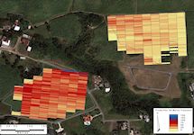
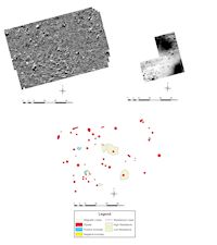
Four forms of survey were undertaken: resistivity survey and gradiometry were used on fields that had young crops (c. 50% visibility) or were down to pasture, while two fields that had been cropped and ploughed were subject to both rapid and intensive fieldwalking. The rapid survey involved fieldwalkers walking alternate ploughed furrows in 30m stretches over two fields, and using a clicker to count how many artefacts were recorded from ridge to ridge (c. 1m). With a team of four walkers, two large fields – Millfield (6 acres) and Upper Tenantry (8.5 acres) - were surveyed and the results provided an overall sense of artefact distribution across the fields (Figure 3). These results were then followed up with intensive fieldwalking, during which selected furrows were again walked in 30m sections, but this time the walkers picked up all the cultural material they saw. This more time-consuming process recovered a wide range of artefacts, predominantly fragments of earthenware, but including imported tablewares, glass, and metal. The artefacts were counted and recorded in the field, with diagnostic sherds retained for further analysis.
Fieldwalking results
The first and most obvious result to note is the density of material spread across the two fields; over 22,000 artefacts were counted. Given the shallow nature of the topsoil that overlies the coral bedrock, it is perhaps not surprising that manuring using broken and discarded ceramics was so intensive. These results quantify for the first time the huge amount of material culture that is available in the cane fields that could yield important information about plantation life. Yet despite the density of artefacts across the fields, important differences are apparent. The two fields were picked for specific reasons. Firstly they had been recently ploughed after harvest and were yet to be re-planted, providing 100% visibility. Secondly, the field names suggested that each field had different associations; Millfield was associated with the manufacturing process and Upper Tenantry with the possible location of the post-emancipation workforce. The difference in the density of material within the ploughsoil can clearly be seen when the data are mapped. The artefact count density was twice as high in Millfield (1.6 per m) as it was in Upper Tenantry (0.5 per m). Although the relative proximity of the fields to the house and factory complex might explain the different densities, it is possible to draw more subtle distinctions when the data are examined in more detail.
Within the fields, variation in distribution is apparent. High densities along roadsides in both fields suggest regular dumping of waste material transported to the fields. Areas within Upper Tenantry also deserve attention. The high density of artefacts in the middle of the field can be explained by a marked undulation in the field, but the high densities around the southern edge suggest sites of possible habitation although no structures are now evident. Having recorded noticeable variations in the spread of material across and between the fields, an intensive phase of fieldwalking was undertaken, during which the material from three transects was collected over 30m intervals. This second phase revealed that, when collecting, the fieldwalkers consistently doubled the number of artefacts counted on the rapid clicker survey.
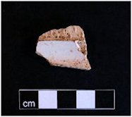
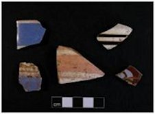
Figure 4: Assemblage from Upper Tenantry showing the presence of whiteware, pearlware and glass suggesting proximity of habitation in the nineteenth century.
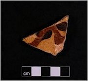
Figure 5: Assemblage from Millfield showing the greater predominance of course earthenwares associated with industrial sugar production and the lesser proportions of tablewares seen in Upper Tenantry.
Ceramic analysis
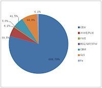
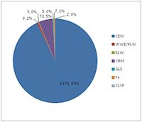
The analysis of the ceramics recovered reveals significant differences in the assemblages from the two fields. In Millfield, 93% (1275) of the artefacts recovered were of coarse earthenware (CEW) and within this broad category most was from industrial products involved in the production of sugar—predominantly sugar moulds and drip pans used to shape the crystallizing sugar and drain off the molasses. Although these forms also made up the bulk of the assemblage in Upper Tenantry, they only accounted for 79% of the collected artefacts. The amount of ceramic building materials (CBM) recovered from both fields was proportionally the same at 5%, and so the major difference was in the amount of refined wares and glass that were recovered. In Millfield less than 2% of the assemblage was made up from whitewares (WWE), pearlwares (PLW), slipwares (SLW) and glass (GLS), whereas in Upper Tenantry these categories accounted for over 15% (Figures 4 and 5). In addition, only three sherds of coarse-bodied earthenwares were recovered that were interpreted as African-Caribbean – one hand-made and two wheel-thrown sherds - all from Upper Tenantry.
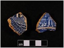
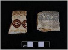
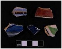
Figure 6: (a) Upper Tenantry: shoulder/rim sherd of a white salt-glazed stoneware plate with barleycorn moulding; second quarter of the 18th century; (b) Upper Tenantry: press-moulded slipware dish with trailed slip decoration; 18th century; (c) Upper Tenantry: transfer-printed whitewares in blue, with the 'Willow' pattern on the left; mid-19th century; (d) Upper Tenantry: sponge-decorated whiteware plate rims, with the pattern 'Grecian' on the right; late 19th century
The analysis of the imported ceramics reveals that they are similar to assemblages excavated from other plantation sites, including the main houses. The range of wares comprised primarily 19th-century white-bodied industrially made earthenwares and less diagnostic lead-glazed coarse earthenwares. Smaller numbers of brown salt-glazed stoneware and refined yellow ware sherds were present, as well as three sherds of mid- to late 19th-century Bristol-glazed grey stoneware. There were also sherds of late 19th or early 20th-century German porcelain, and single sherds each of mid- to late 18th-century white salt-glazed stoneware (Figure 6a), unrefined yellow ware, undiagnostic stoneware and press-moulded slipware (Figure 6b). Whitewares constituted the largest group, with 278 sherds, and the forms were predominantly plates (39.7% of the identifiable whiteware forms) and bowls (16.5% of the identifiable whiteware forms), but dishes, chamber pots, basins, cups, saucers, jugs, mugs and a number of covers were also present. A number of the covers found appear to be from chamber pots, typical of hot climates. Other covers include a probable vegetable dish or soup tureen cover and a possible teapot cover. Decoration, where present, included transfer-printed, under-glaze painted, sponged and banded slip designs. The printed patterns occur on a limited range of forms – predominantly plates, some possible serving dishes, a cup, a jug or mug, and a cover that may be from a teapot. Only two printed patterns were identifiable. Several sherds of the first of these, the ubiquitous 'Willow' pattern (Figure 6c), were recovered. 'Willow' was made by almost every 19th- and early 20th-century manufacturer of industrially produced earthenwares, and was in fact the cheapest of the printed patterns available. The other identifiable pattern is 'Asiatic Pheasants', with just one definite sherd from Upper Tenantry. This pattern, although widespread during the second half of the 19th century into the early 20th century, never quite achieved the same popularity as 'Willow'.
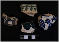
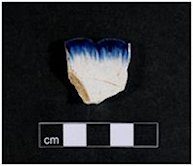
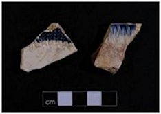
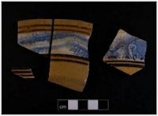
Figure 7: (a) Upper Tenantry: whitewares with cut-sponge and under-glaze painted decoration; mid- to late 19th century; (b) Upper Tenantry: whiteware plate with moulded shell edge with even scallops, coloured blue under the glaze; 1820s-1840s; (c) Upper Tenantry: whiteware plates with moulded shell (right) and leaf frond (left) edges, coloured blue under the glaze; 1830s-1840s; (d) Upper Tenantry: whiteware sherds with slip decoration; mid- to late 19th century
Figure 8: (a) Upper Tenantry: pearlwares and whitewares with under-glaze painted decoration and (top right) banded and feather slip decoration; mid-19th century; (b) Upper Tenantry: refined yellow wares with banded slip and mocha decoration; mid-19th century
Of the numerous patterns formed by cut-sponge motifs, one can be identified as 'Grecian', a grey pattern (three sherds) that was made by a number of manufacturers—mostly, if not entirely, Scottish—from c. 1875 (Figure 6d). Sponge-decorated vessels include mainly plates, with smaller numbers of chamber pots, bowls and jugs; there was also a possible basin. Under-glaze painted decoration also includes bold stylised leaf patterns in blue or polychrome colours, broad bands and, in one case, a chequerboard motif (Figure 7a). There are five examples with a moulded shell edge (Figure 7b) and another with an edge pattern of leaf fronds in relief (Figure 7c). The other decorated whitewares are those with dipped and banded slip decoration, which occurs in a variety of forms. Simple bands in blues, brown and, unusually, pink adorn, predominantly, bowls, but also covers, a mug and a possible basin or chamber pot (Figure 7d). In some cases the slip has been manipulated to form a cat's eye or feathered pattern (Figure 8a). At least thirteen sherds of refined yellow wares were recovered with identifiable forms from bowls, while other forms include basins, chamber pots, a dish and a jug. Half of the sherds are decorated with banded slip, while some of the larger vessels also have dendritic mocha patterns in blue or green on broad white slip bands (Figure 8b). A small number of stoneware sherds include fourteen of brown salt-glazed stoneware, of which nine are from small cylindrical blacking bottles; four others may be jars. Three sherds of Bristol-glazed grey stoneware are from bottles or jars. Another sherd, of a jug or bottle, is in an undiagnostic stoneware. A range of coarse earthenware types is present, of which 45 sherds (11.1% of the ceramics) are probably of British origin. Some are the familiar dark brown/black glazed dishes, jars and other large forms that were made at many British workshops during the 17th to early 20th centuries, but which are impossible to source and difficult to date closely. Another sherd is possibly of north Devon gravel-tempered ware, and other north Devon vessels may be present. A date range of late 17th to late 19th or early 20th century is represented by the sherds recovered, with a majority dating to the mid- to late 19th century.
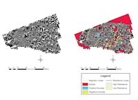
A further four fields closer to the main house were subjected to non-intrusive survey—resistivity survey and gradiometry (Figure 9). In the three fields where resistivity was used, little beyond the underlying geology was revealed, although hints of correlations with the magnetic data were revealed in one paddock. Mount Plantation is situated on the Second High Cliff, which extends roughly east-west across the mid-section of the island. The geology is Pleistocene coral reef limestone cap—a coral rock which, as is evident at Mount, has been cut in blocks as a building material (Donovan with Harper 2005). It would be necessary to survey a greater area in order definitively to assess the technique's suitability to detect subsurface deposits on this geology, as so little evidence was shown in the fields surveyed.
Figure 10: Lower Pasture surveys including gradiometry (top left), resistivity (top right) and combined interpretation (bottom). Gradiometry survey shown at -6nT (white) to +6nT (black) with high density sampling undertaken in the south-western corner (0.5 x 0.25m interpolated to 0.25 x 0.25m) shown at -6nT (white) to +6nT (black). Resistivity survey undertaken shown at 45 ohms (white) to 90 ohms (black)
Gradiometry proved the more successful technique. The first field surveyed was under a young crop of cane, although its name 'Lower Pasture' suggests it has not always been a cane field. The gradiometry plot (Figure 10) shows the characteristic lines of ploughing, particularly when the survey was conducted at double density, and the widespread distribution of ferrous litter. A single significant feature is also apparent—a penannular positive anomaly approximately 4.5m in diameter and associated with two ferrous responses. However, its nature cannot be securely determined; its shape is occluded by ploughing, and would require more intensive investigation. Comparison with the resistivity data merely confirms the presence of stones in the cultivation ridges present at the time of survey. The second field (Figure 11) was a paddock of permanent grass, and the survey displayed magnetic disturbances in the north-east corner and western edge with ferrous responses found across the plot. Some NNE-SSW linear anomalies could relate to human activity, considering their association with iron responses, but there is little that can be identified with any certainty and the hillside context is more suggestive of recent natural processes, such as water run-off channels incorporating ferrous material. As the paddock is permanent pasture without any visible ferrous litter beyond a water trough at the northern boundary, historic human activity remains possible.
Figure 11: Gradiometry survey of horse paddock west of Lower Pasture (left) and interpretation (right). Shown at -6nT (white) to +6nT (black)
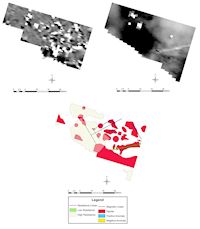
The third area surveyed (Figure 12) was a small plot of land now down to pasture and ornamental horticulture adjacent to a chicken shed. The resistivity shows two large high-resistance anomalies representing rises in the bedrock, mottling in the south-eastern corner that could be ascribed to human interference, and a strong east-west low-resistance linear feature seemingly terminating with a high-resistance counterpart, most probably modern/historical services. Strong dipolar responses were found across the central and eastern portions of the survey, which may conform to a pair of rectilinear arrangements measuring 15 x 10m and 10 x 5m, though the weakness of the anomalies hinders more confident interpretation. The size of both arrangements and their situation on flat ground may be indicative of building platforms.
Figure 12: Surveys north-east of the chicken shed. Gradiometry survey (top left) shown at -12nT (white) to +12nT (black). Resistivity survey (top right) shown at 25 ohms (white) to 55 ohms (black). Combined interpretation shown at bottom
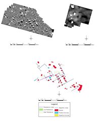
The clearest results that represent human activity came from the area to the west of the chicken shed (Figure 13), again an area of permanent pasture/horse paddock, between the road and the plantation house. Subtle linear anomalies are apparent across the survey plot, in many cases in association with ferrous responses, the most intriguing of which are the series of paired responses in the centre-east of the plot. There is a correlation between broad linear trends in the resistivity results and those in the gradiometry surveys. The subtlety of the linear anomalies is reminiscent of those in the paddock to the east of the house, although their distinct association with regular dipolar anomalies and situation on flat ground seems here to provide a stronger argument for an archaeological rather than geological origin, supported by their alignment in both plots, either side of the chicken shed. In a landscape where the target archaeology is likely to be transient, the subtlety of responses should not be surprising. Where little magnetic contrast has been introduced by the creation of archaeological features or by the use of masonry, other possible indicators must be invoked. In this instance the arrangement of ferrous responses may yield the best clue to the location of dismantled structures.
Figure 13: Surveys south-west of the chicken shed. Gradiometry survey (top left) shown at -6nT (white) to +6nT (black). Resistivity survey (top right) shown at 40 ohms (white) to 70 ohms (black). Combined interpretation shown at bottom
Internet Archaeology is an open access journal based in the Department of Archaeology, University of York. Except where otherwise noted, content from this work may be used under the terms of the Creative Commons Attribution 3.0 (CC BY) Unported licence, which permits unrestricted use, distribution, and reproduction in any medium, provided that attribution to the author(s), the title of the work, the Internet Archaeology journal and the relevant URL/DOI are given.
Internet Archaeology content is preserved for the long term with the Archaeology Data Service. Help sustain and support open access publication by donating to our Open Access Archaeology Fund.