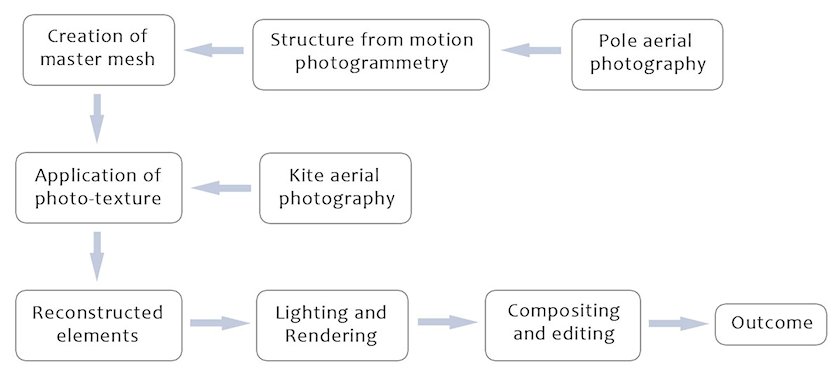
Here some of the challenges of gathering low altitude aerial photography at Jarlshof will be introduced, along with an explanation of the hardware and software solutions that were used during production. For this project, structure and colour information were gathered and processed separately (see Figure 4), in part owing to practical limitations at the image-gathering stage. Adopting this workflow allowed for the incorporation of a range of gathered lighting conditions, meaning that the final outcome could be kept closer to the original photographs. This contributed to the end aesthetic and tied in with the aims of the animated outcome.
While all of the three-dimensional data were generated specifically for the project, the approach used for texturing and rendering could also be applied to existing survey data where available. The methods used to generate the three-dimensional data on this project demonstrate some highly accessible and cost-efficient ways to facilitate an animated visualisation, even where access to low altitude aerial photography is limited.
Jarlshof is situated at Sumburgh Head, on the southern tip of the South Mainland in the Shetland Islands. The site occupies an area approximately 160 metres by 80 metres, which is owned and cared for by Historic Scotland. To gather imagery of suitable coverage and detail, a variety of low altitude aerial photography platforms were considered.
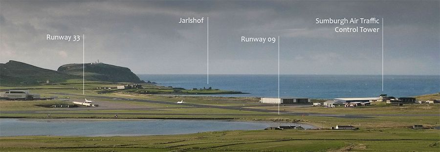
Less than 300 metres lie between the perimeter of the site and the boundary of Sumburgh Airport, which takes a large amount of air traffic (Figure 5). As well as scheduled and non-scheduled fixed-wing aircraft, the airport is also frequented by helicopter traffic serving both the offshore oil industry as well as search and rescue exercises and operations. As such, from the outset it was clear that if kite aerial photography was to be made possible at the site, it would be at the discretion of air traffic control, as governed by their own safety and logistical concerns.
Because of this constraint, two methods of image gathering were adopted. The first, using a pole-mounted camera, avoided altitudes that would interfere with air traffic. This allowed a camera to be lifted to around 6m height and operated for prolonged periods without interference. This method proved most useful for gathering sequences of photographs in traverses across the site to provide three-dimensional data using structure from motion (SFM) photogrammetry.
The second method adopted was kite aerial photography, which was conducted with special permission and at the discretion of Sumburgh Airport Air Traffic Control. This allowed photography from up to 60m elevation for shorter periods, usually within a granted 1-hour window. The greater simultaneous coverage area allowed by this method made it more suitable for gathering photo-texture information, later to be combined with the SFM data. Kite aerial photography depended on specific weather conditions, particularly as a variety of lighting conditions were required. At the beginning of each session a phone call was made to the assistant air traffic controller to request permission for kite flying for a given time window. During this time the air traffic controller could request that the equipment be landed immediately should there be incoming traffic. Another call was made to confirm the end of each session.
The camera used for both methods of image gathering was a Panasonic DMC-LX3, which afforded a lightweight solution with full manual control and high-quality optics. In addition, the camera allowed for continuous shooting with no additional hardware, other than an ultra lightweight strap to hold down the shutter button. The camera was either fixed to a bespoke extendable pole with a lightweight ball-and-socket tripod head attached or suspended from the kite line by a 'Brooxes Simplex' rig, which held the camera in place via a Picavet configuration. While a variety of kites were on hand, a small 'Sled' kite of around 1m² surface area proved most suitable for the strong wind conditions that prevailed during the fieldwork. For both pole-mounted photography and kite aerial photography the camera was left to shoot continuously around every two seconds with no electronic downlink or control from the ground. The resulting excess of images provided an ample resource for both SFM photogrammetry and still photography.