Kieran Baxter, Duncan of Jordanstone College of Art and Design, University of Dundee, Dundee DD1 4HN Email: k.a.baxter@dundee.ac.uk
Cite this as: Baxter, K. (2014). Jarlshof Lost and Found: Low altitude aerial photography and computer-generated visualisation for the interpretation of the complex settlement remains found at Jarlshof, Shetland. Internet Archaeology, (36). http://dx.doi.org/10.11141/ia.36.1
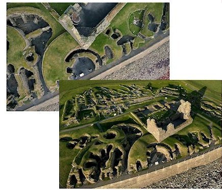
This article discusses the approach and methods adopted during a computer-generated visualisation project, which resulted in the animated outcome 'Jarlshof'. The challenge of visualising the relationships between a sequence of lost structures and the remains as they exist today was tackled by setting reconstructed elements within a computer-generated reproduction of the current day environment. The resulting imagery closely resembled the low altitude aerial photographs that the outcome was based upon.
The process by which the existing structure and surface texture information was gathered and the resulting imagery synthesised with other upstanding sites, as well as fabricated elements, is discussed in terms of the methods and approach used. Discussion reflects on how a focus on gathered imagery contributed to the fidelity of the end aesthetic, and how photographic and cinematic considerations were incorporated into a narrative toolkit in order to tell an 'improved' story of the site. The role of the camera and the appropriateness of the low altitude aerial perspective is also raised.
Go to Table of Contents.