
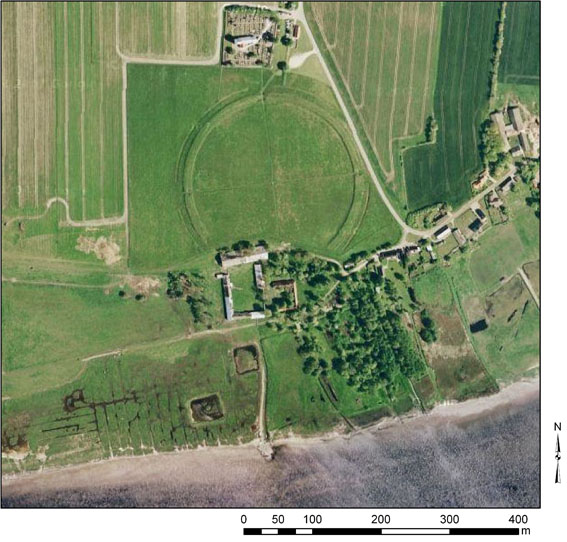
On the north coast of the Limfjord, which transects the Jutland Peninsula, the site of Aggersborg (Figure 1) comprises the remains (now partly restored) of the largest known fortress from Viking-age Scandinavia; it also holds vivid evidence of a rich settlement that had burned down prior to the construction of the fortress. Together, these remains are archaeological testimony to a conflict between modes of social power, which was common in Northern Europe in the Early Middle Ages.
The site was located in an area of particular strategic importance. Throughout the Viking Age, the Limfjord – then a strait open towards both the east and west – was a principal sailing route between the North Sea and the Baltic, being comparatively safe for navigation compared to the treacherous route through the Skagerrak between the northern tip of Jutland and Norway (Figure 2). There are also indications that an outlet (the Sløjen canal) from this position directly north into the Skagerrak may have been open during the Viking Age (Møller 1986, 24). Aggersborg was located at an important road-crossing, and at a site where all the main channels of the fjord merged and could potentially be exploited or guarded. The importance of the Limfjord as a sea lane diminished, however, after the western outlet into the North Sea silted up in the early 12th century (Roesdahl 1986a, 81).
The fortress lies only c. 10m above present-day sea level, and approximately 350m from the current coastline. Except for cultivation and the partial reconstruction of the earth ramparts, most of the site is virtually untouched by later activity. In some areas the Viking-age features are protected by thick layers of wind-blown and water-eroded soil, including material eroded from the original earth ramparts of the fortress. Aggersborg thus has a high research potential, while, as a scheduled monument, the scope for traditional archaeological fieldwork is closely restricted.

Large-scale excavations were carried out in parts of the site by the National Museum of Denmark in 1945-54 (Schultz 1949). Further trenches were investigated in 1970 (unpublished) and 1990 (Ulriksen 1995). The excavations cover some 13,500m² combined, and record approximately 19,500 features, more than 30,000 artefacts, and large quantities of animal bone (Pedersen 2014). The excavation records were left unpublished when the site excavator, C.G. Schultz, died unexpectedly in 1958. Preliminary reports were presented by Else Roesdahl (Roesdahl 1976; 1981; 1986a), but work on a comprehensive publication was impeded by the fact that the site archive and field notes had been left with virtually no key or guide. Since 2008 a team consisting of Else Roesdahl (University of Aarhus), Anne Pedersen (the National Museum of Denmark) and Søren M. Sindbæk (University of York and University of Aarhus), has worked towards presenting the first comprehensive analysis of the archive and finds from the site. In the process new problems have also emerged, which form the point of origin for the fieldwork presented in this article.