Data at first sight seem to be about factual information, computer systems and standards. It does indeed involve all of these things, but data also derives from, and lays bare, crucial social and organisational relations. Archaeology has a well-recognised tendency towards fragmentation, with commercial practices, local authority archaeologists and academics respectively being driven by varying motives, different funding streams and different desired outcomes. All are under pressures of time and money, but are also united in an attempt to understand the past. As well as our technical recommendations, an increased sense of collaboration between academic researchers, commercial archaeologists and planning bodies is also needed (Bradley 2006). We have already begun this by hosting a very successful collaborative seminar that drew on the combined expertise of representatives from the relevant HERs, English Heritage, and project and geomatics managers from some of the major practices working in the study area. The local authority archaeologists for Wiltshire and Gloucestershire have been strongly supportive of this project. They have provided assistance both with advice and with information from their HERs. We anticipate that the recommendations made by this project will be of significant value to them in their planning work. Furthermore, since this problem (lack of integration) is a national one, English Heritage has also been extremely supportive in the development of this pilot project.
The integration of cropmark, geophysical, evaluation and excavation evidence within a single GIS database (and, if possible, the addition of results from, for example, fieldwalking by local voluntary groups and individuals) should allow for more efficient desk-based assessments, a more nuanced understanding of risk-by-period for planning purposes, and better awareness of the overall archaeological potential of an area prior to field evaluations. In some cases, a high level of existing knowledge and understanding of risk could even reduce the need for large-scale evaluation by trenching events; this could instead be replaced by more targeted and in-depth excavation sampling. More freely available digital data can also become the basis for greater public engagement with archaeology and other evidence of the past.
The next phase in our work is to use the data we have to gain a better understanding of the landscapes of this uppermost part of the Thames Valley. We are now creating a series of phased landscape plans, using the spatial data we have collected. One aspect of interest that has already emerged is that we can start to recognise and to think about the 'negative spaces' in the landscape – areas in which little or no activity is archaeologically detectable – as well as the areas of intensive activity.
In the overall study area, the Neolithic and Bronze Age appear to be only very lightly represented in the uppermost Thames Valley, as compared to the middle and lower Thames. This suggests rather different long-term histories in these areas; additionally, in some specific regions of the study area, we noted that certain periods were particularly poorly represented compared to neighbouring regions (notably the sub-Roman/Saxon period). Possibly, certain factors, whether social, political, or environmental, led to an under-exploitation of these regions. Alternatively, these 'holes' may be in some instances an artificial by-product of excavation methodologies. If the open area stripping technique is applied, without careful sampling of topsoil and subsoil layers, it is possible that some of the shallow archaeological material (perhaps the absent sub-Roman evidence) is being machined away. This is a real concern and one which it may be possible to address by analyses of the site methodology of the investigations within these period-based 'blank spots'. It may be that more appropriate techniques could be devised for large-scale developer-funded work that would answer this question.
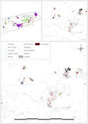
In some instances, however, comparison of the excavated information with the NMP cropmark mapping strengthens the argument that these areas are truly lacking in archaeological features. Such comparison can also help to suggest a chronology for some previously undated cropmarks, as we can now link the dating evidence for excavated portions with their fuller extent as linear cropmarks in the wider landscape. These may indicate a series of negative spaces that constitute part of the very organisation of the landscape, being apparently blank areas between settlements or fields. Despite there being no obvious difference in topography or geology, there are some locations that appear to have been left 'unused' across immense swathes of time, in some instances from the Iron Age into the post-medieval period (Figure 7). These could have been areas of common pasture or woodland, for example.