Evidence for sea crossings between the mainland and Farasan Islands alone is not enough to imply that people were crossing the Red Sea, even if the distance between the Farasan Islands and mainland is comparable to the distance across the Bab-al-Mandeb. Contact and trade across the Red Sea has been investigated by Khalidi (2010), through tracing the movement of trade items (obsidian), and demonstrated contact during this period, although it did not go so far as to assess the impact of such links on subsistence strategies. It is not until c.4000 ka cal BP that there is a traceable widespread movement of new cultural features across the Red Sea, with pottery and farming from Africa entering southern Arabia (e.g. Durrani 2005).
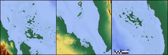
The seafaring requirements necessary to reach the Farasan islands indicate that populations were probably capable of crossing the Red Sea. The Farasan islands are over 35km from the mainland, and the shortest stretch of open water across the Red Sea today is a little over 20km at the Bab-al-Mandeb (Figure 2b); while reaching the Farasan Islands from the Arabian mainland would require island hopping across stretches of open water with sea crossings of at least 10km. Given that the visible horizon is roughly 5km at 2m above sea level (for example, standing on a beach, or on a small vessel) this implies that one might not necessarily have to lose sight of land when travelling to the Farasans. However there are a number of factors that complicate this interpretation, including the haze generated by humidity and dust throughout the year that can reduce visibility. The presence of higher relief both in the Farasan Islands (up to 70m) and in an isolated location on the mainland (30m in Jizan) can extend visibility. Additionally many of the islands between the Farasans and Jizan are less than a kilometre in size, and less than a couple of metres high. Satellite images show that these are either sand bars that have accumulated as a result of incremental growth, or small coral atolls. It is uncertain whether these would have broken the surface six thousand years ago given evidence that local relative sea levels were as much as 2m higher than today, as evidenced on the Farasan Islands, and adjacent mainland by palaeoshorelines dated from the coastal sites located on them. The majority of these features are 2m or less in height, and would likely have been submerged during the period of midden formation, thus necessitating a minimum of a 35km open sea voyage to the Farasan Islands 6000 years ago (Figure 2c).
The Dahlak Islands on the opposite side of the Red Sea, however, are more accessible from their adjacent mainland (Figure 2a), with a maximum 10km of open sea to cross to a mid-way island. There are a further two smaller islands between this and the mainland that may or may not have been submerged during the mid-Holocene. Even if these two smaller islands were not in existence, the elevation both of the mainland and of the mid-way island would have ensured inter-visibility between them, and most likely inter-visibility between the mid-way island and the Dahlaks beyond as well. The Dahlak Islands are therefore theoretically more accessible than the Farasan Islands.
Both sets of islands were formed by the same processes (salt deformation resulting in diapirism – salt domes uplifting the islands – see Heaton et al. 1995), creating very similar physical environments that are influenced by very similar climatic and oceanographic conditions. It is likely that similar coastal environments and marine ecosystems existed on both archipelagos. The Farasan Islands have a very rich and productive marine ecosystem, supporting a large biomass (Gladstone 2000). This has been extensively exploited in the past (from the mid-Holocene) to the present, by fishing and shell gathering.
The Dahlak Islands are likely to be as productive as the Farasan Islands (e.g. Araya and Mohan 2012) and given their easier accessibility it seems likely that these would have been exploited in a similar way in the past. The modern conditions certainly appear similar to those on the Farasan Islands. Therefore the research techniques and methods developed and employed in the Farasan Islands (Meredith-Williams et al. 2014) to search for signs of prehistoric coastal exploitation were applied to survey of an extended area of the southern Red Sea encompassing southern Saudi Arabia, Yemen, Eritrea (including the Dahlak Islands) and southern Sudan.