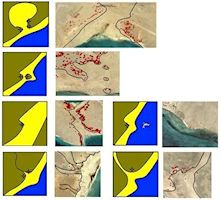
The site location model works particularly well in locating palaeoshorelines at a broader scale and using these to initiate the targeted higher-resolution detection of sites. The reconstruction of palaeoshorelines has allowed an assessment of how the islands might have looked during the mid-Holocene when local relative sea levels were higher in this area (after Meredith-Williams et al. 2014). It is interesting that the model closely resembles Fischer's (1993) Fishing Site Model; the main difference being the necessity of having a shallow subtidal zone to support productive and accessible shellfish beds (Figure 10). The fishing site model was originally developed for the location of Mesolithic fishing sites in Denmark. As our model for locating mid-Holocene shell midden sites in the Red Sea developed, it became apparent that there were broad parallels between the two models. Indeed fishbone is a constituent of the majority of excavated shell middens on the Farasan Islands. However the key component of the Red Sea model is the presence of accessible shell beds, whereas the fishing site model requires access to fishing sites. Fishing sites and accessible shell beds are not mutually exclusive, and the focus of both is accessibility to resources. It is therefore not surprising that the fishing site model only requires the addition of an accessible shell bed to be applicable to shell midden sites.
Large concentrations of shell middens are important for a number of reasons, not least because the number of prehistoric sites that survive and are visible under normal circumstances is usually very low. The detection, by remote sensing, of c.4200 shell midden sites has a significant impact on our understanding of prehistoric coastal exploitation during the Holocene in the Red Sea. Previously only around 20 shell midden sites were known, with most thought to be associated with sporadic coastal exploitation and herding (e.g. Bar-Yosef Mayer and Beyin 2009; Tosi 1986; Zarins et al. 1981). The discovery of over 3000 shell middens on the Farasan Islands, and their subsequent analysis (e.g. Bailey et al. 2013; Demarchi et al. 2011; Meredith-Williams et al. 2014; Williams 2010) suggests that these offshore sites are representative of well-developed coastal economies (Figure 9), and the same is likely true of those on the west side of the Red Sea. From evidence on the Farasan Islands, these economies also included fish and gazelle (Bailey et al. 2013), with shell-fish the most obvious component.
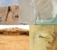
The fact that over 4200 sites have been identified in the southern Red Sea means that the archaeological record is heavily biased towards shellfish exploitation. This is because of the robust nature of the shells compared to other types of discard, and it is likely that this element did not contribute as great a component of the diet as suggested by the large number of surviving shells in the archaeological record (e.g. Meehan 1977). The robustness of the shell is what allows it to form mounds, and contributes to visibility in the archaeological record. Also, the taphonomy of the offshore islands in the Red Sea is suited to the preservation of shell mounds. The aridity and historically low population densities mean that shell mounds are less exposed to erosion, sedimentation, and site reuse and damage in later periods. The moisture that is available often promotes calcium carbonate re-deposition, which can help to stabilise the sites. They are therefore often highly visible in the landscape, particularly on high-resolution satellite images as described in this article.
The nature and variability of this bias can also be seen in the differences in assemblages between the excavated shell midden sites. The most notable difference is the presence of domesticates in some mainland shell middens, and their absence in the island sites (e.g. Tosi 1986; Bailey et al. 2013).
The difference between mainland and island sites goes further than composition, as described above. Their shapes also differ, with mainland sites tending to be lower wider mounds (often c.1m high, 100m across – Bar-Yosef Mayer and Beyin 2009; Tosi 1986a>; Zarins et al. 1981), with island sites often more restricted (<50m across), but sometimes being much taller (up to 6m, as recorded on the Farasan Islands). This could suggest two separate groups — herder-gatherers on the mainland and fisher-gatherers on the islands — or a group that engaged in these different activities at different times of the year, or even a group that split for part of the year. In a further complication, Beyin and Shea (2007) report inland shell middens around the palaeoshorelines of the Buri palaeolake. This raises the possibility that many different communities coexisted along the coastlines, living in different ways with different economies, and exploiting the resources as local conditions and opportunities dictated.
The apparent presence of high concentrations of shell midden sites on both sides of the southern Red Sea raises some interesting questions. The sites have the same spectral signatures, same landscape settings, and same outline shapes. This would suggest that they were formed as part of similar, or the same, formation processes. It is therefore possible that the sites result from similar activities being undertaken on both sides of the southern Red Sea. This scenario is not unlikely, since both sides of the southern Red Sea are characterised by diapiric archipelagos formed by salt movement. These are predominantly composed of limestone and uplifted fossil coral terraces. The physical environments and climate are therefore very similar, resulting in similar ecosystems and opportunities for exploitation. It is perhaps unsurprising that exploitation within similar environmental constraints might lead to the formation of a similar set of sites.
However it is also possible that the sites are the result of contact across the Red Sea. It is interesting that the inland sites recorded by Bar-Yosef Mayer and Beyin (2009) are notably different from the sites located in this survey. They do not conform to the model for site location that we have generated for the Farasan Islands, and it is probable that they were formed as part of a different lifeway to those on the islands (as noted above), and around the coast. Perhaps as Bar-Yosef Mayer and Beyin (2009) suggest, these inland sites were formed by herder-gatherer communities, much like those on the Saudi mainland, while those of the Dahlaks and other areas of the western southern Red Sea coastline were formed by hunter-fisher-gatherers, equivalent to those on the Farasan Islands.
The idea that people might have been crossing the Red Sea at this time is not a new one. Work on obsidian sourcing has already demonstrated contacts between the Tihamah coastal plain on the eastern side of the Red Sea and East Africa (Khalidi et al. 2010) between the sixth and first millennia BC. This fits the main period for the accumulation of shell midden sites in the southern Red Sea that date to 8000–4500 ka cal BP (Bailey et al. 2013; Bar-Yosef Mayer and Beyin 2009; Demarchi et al. 2011; Tosi 1986; Williams 2010; Zarins et al. 1981). The fact that many of the sites accumulated on islands necessitates the use of boats and the distances involved in reaching the islands is comparable to that of crossing the Red Sea.
These data and interpretations point to new lines of research. Many of the sites still need to be ground-truthed: further analysis using high-resolution false colour composite images will also help to increase the accuracy of the method. Likewise the height of many of the sites could be calculated from high-resolution images using shadows where the sun is at a low angle. To further investigate the crossings, isotope analysis of human bone could be employed e.g. through strontium analysis which could be used to investigate where people lived during different parts of their lives.