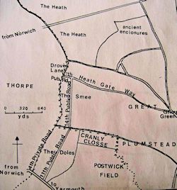
Using these same sources, albeit without the aid of GIS, Carter (1984) produced a reconstruction of the battlefield, which consolidated her sources onto a sketch of the 1812 enclosure map. While the diagram (Figure 10) defined the area's road network, alongside ancient enclosures like Peke Herne and Cranly Close, it did so without an accurate base map or reliable gradient data, and so inevitably lacked the precision afforded by modern terrain reconstruction methodologies. This led to a small but significant error regarding Dussindale's exact position, with Carter claiming that the valley followed the route of the enclosure award's eleventh and fourteenth public roads, the modern Green Lane, based on a misreading of the historic landscape. By assuming that the Old Ditch was synonymous with a watercourse depicted on Faden's map, which ran along the enclosure award's fourth private road, the modern Boundary Lane, Carter (1984) used Cooke's plan, showing Dussindale 200m east of the ditch, to assert that the valley overlapped with the Smee and Doles. Figure 11 shows these locations in relation to the modern landscape.
This supposition, however, is contradicted by the court book's previously noted indication that the Old Ditch formed the western edge of Ward's 'Bruery', and by Harrison's portrayal of Dussindale running 'from the nook of the east part of Thorpe Common, directly towards Drove Lane', along the route of the watercourse depicted on Faden's map. Similarly, both Cooke and the 1589 map position Little Lumners Close east of the Old Ditch and west of Drove/Lumners Lane, while a Thorpe enclosure award described the Postwick boundary following Drove Lane south before crossing the Smeeth to Yarmouth Road, 'leaving the south east corner of […] Little Lumners, about ten yards to the right' (Anon. 1812b). These sources imply that Dussindale, not the Old Ditch, represented the 1812 parish boundary, which had been altered in recognition of Harrison's assertion that the valley would form 'a natural and lasting Division' between Thorpe and Postwick. Although Carter erroneously situated Dussindale 200m east of its true position, the preceding section has shown how terrain analysis can redress this and accurately define the battlefield's position within the historic and modern landscape (Figure 12 and Figure 13).