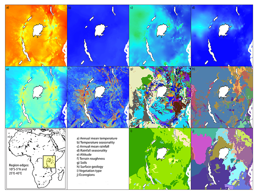
The continental-scale maps in Figure 3 suggest that, in addition to the variables shown on these maps being dominated by different overall patterns, there is also geographic variation such that east, west and south differ from each other. Given the significance of these three regions for understanding human evolution and prehistory, and the fact that environments are highly complex so simple continental maps might be expected to conceal considerable smaller-scale variation, it is worth looking at these geographic patterns in more depth. Here, four 15x15 degree tiles have been selected as foci (see Section 2 for details), one for each area where we find hominin fossils and one, for contrast, in a region with no hominin presence ('central Africa'). This sort of area is likely to span the ranges of several hominin species, which may co-occur and interact. I will begin with east Africa, which may be the source of many hominin species, including early members of our own genus Homo (Anton and Swisher III 2004).
On the continental maps, East Africa appeared to show the least amount of latitudinal banding. Instead, these environments (particularly, though not exclusively, the physical landscape variables) were dominated by patterns associated with the East African Rift Valley, which may also be significant either for the preservation of hominin fossils, or as a source of attractive landscapes for hominin occupation (Winder et al. 2013; 2014). But what does this area look like at the regional scale?
In fact, when we focus on east Africa at the regional scale, it is the Rift Valley that dominates. The Rift is, of course, very visible on maps of topography and terrain roughness (Figure 4e-f), with both east and west faults producing high-altitude, rough ridges. Interestingly, these ridge features are not in fact as visible in the surface geology map (Figure 4h), though some patches of different rock types are visible along their peaks. The soils map (Figure 4g) is similar, in that while there is no single soil type that defines the rifts, the patterns are nonetheless irregular and show some tendency to spiral in a north-south direction.
The variables that were classed as 'intermediate' in patterning at the large scale, and which showed at least some latitudinal banding continentally, here also show irregular patterns. The ecoregion map (Figure 4j) in particular shows two clear bands running along the eastern and western rifts. The eastern peaks are covered by blocks of East African montane moorland, embedded in a matrix of East African montane forest (dark and light brown respectively), while the western ridge is covered in Albertine Rift montane forest (dark purple). The map of east African vegetation (Figure 4i) does not delineate the rift features themselves as clearly, but is still markedly irregular: the band of closed vegetation which cut across the continental map fairly clearly here tails off untidily; it is over 10 degrees wide to the left of the region and has shrunk to a point before crossing to the right-hand side. There is also a band of coastal forest, and some irregular patches of open vegetation can be seen in the region.
In east Africa, the influence of terrain and the predominance of irregular patterning does not end with the physical landscape and some 'intermediate' variables; it can also be seen in maps of climate (Figure 4a-d). In east Africa, there is little or no evidence of latitudinal banding patterns even in these variables, with even the clearest such pattern – in rainfall seasonality (Figure 4d) – twisted and curved by the topographic anomalies. Maps of annual mean rainfall, temperature and temperature seasonality (Figure 4a-c) here show no latitudinal patterning, instead showing bands spiralling around the edges of the Rift Valley and orientated more north-south than east-west, particularly in the annual mean temperature map (Figure 4a).
The landscapes of east Africa, at the regional scale, are thus landscape-dominated (and hence largely irregularly patterned). The major landscape features – associated with the rifts and peaks that have been proposed as a key attractor for the early hominins – break up what might otherwise be latitudinal banding patterns in both those variables referred to as 'intermediate' in the continental scale and the climatic variables.
Most hominin fossils come from east and south Africa, but there are two – Sahelanthropus tchadensis and Australopithecus bahrelghazali (reported by Brunet et al. 2002, and Brunet et al. 1995 respectively) – from Chad in the west. Both are, however, still known only from a small number of fossils, and it is not yet clear whether they reflect the long-term presence of hominins either across sub-Saharan Africa or just in the west, or result from the occasional excursion by hominins from other areas. West Africa, though not yet firmly on the map for studies of ancient environments, is therefore of growing interest to palaeoecologists and prehistorians.
Looking at west Africa specifically, there are fairly clear latitudinal bands visible on maps of temperature seasonality, rainfall seasonality and vegetation (Figs 5b, d and i), though the edges of these appear more ragged at the regional scale. There are relatively few anomalies on these maps, just a single patch of aquatic vegetation associated with Lake Chad and some modification of the climatic banding associated with the Cameroon line. Some latitudinal banding is also visible on the map of annual mean rainfall (Figure 5c), though this also shows a coastal effect in which the shoreline receives more rain than inland areas, and on the ecoregion map (Figure 5j). That these two maps do not show such clear-cut latitudinal bands is interesting because the continental maps suggested that west African climates were fairly comprehensively dominated by banding patterns.
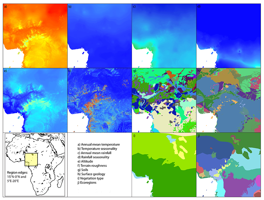
Moving on to look at the physical landscape maps, we can see a further difference between the picture of west Africa obtained from the continental maps and the regional view – the greater influence of the Cameroon line, a 1000km ridge of volcanic peaks that runs along the Nigeria-Cameroon boundary and is visible striking north-east from the southern coastline on Figure 5e. This feature is clearly apparent on regional maps of topography and roughness (Figure 5e-f), and can also be seen as a line of volcanic outcrops – coloured orange and dark red-brown – on the surface geology map in Figure 5h, but was not very visible at the continental scale, perhaps because its peak height, at just over 4000m above sea level, is dwarfed by the larger peaks of nearly 6000m in east Africa. The patches of volcanic rock correspond roughly with the areas of Cameroonian highland forest (coloured pale yellow) that are visible on the ecoregions map (Figure 5j). This ecoregions map also shows pairs of similar, but not identical, ecoregions on either side of the Cameroon line that together form rough latitudinal bands; to the north, for example, the very dark and pale blue ecoregions at ~10-12°N delimit areas of West Sudanian savannah and East Sudanian savannah respectively, and the mid-blue/green pair beneath them are similarly closely related.
In west Africa, then, we can say that our impression from the continental maps (that this was an area of landscapes largely dominated by latitudinal banding patterns) has held approximately true, as six of the ten environmental variables studied show some banding. As we move to a smaller scale, however, the influence of topography – and particularly the Cameroon line – has become more apparent, especially on maps of ecoregions and geology that were considered 'intermediately' patterned at the continental scale.
The region described here as 'central' Africa, unlike the other three areas, has not produced any hominin fossils to date. This may imply that there were never any hominins present, or it may result from some combination of other factors including taphonomic bias, a lack of survey work and sporadic or short-lived hominin occupation.
Focusing in on the environments of this region, there are fairly clear latitudinal bands on maps of temperature seasonality and rainfall (Figure 6b-c) and weaker banding patterns on those of temperature and vegetation (Figs 6a and 6i). The temperature map, however, shows bands modified by coastal processes – there is, roughly speaking, a cool band across the middle of Figure 6a, but it turns southward along the coastal strip in the west. Likewise, although there is a fairly clear band of closed vegetation towards the north of Figure 6i, the southern portions of this map are much more irregularly patterned and also show some evidence of coastal effects. The final climatic variable, rainfall seasonality, shows no variation across the region.
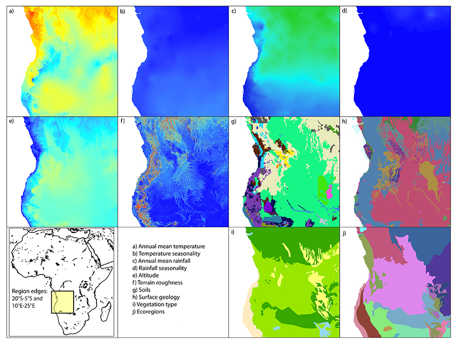
Looking at the physical landscape maps, things are once again irregular and dominated by coastal anomalies. The topography map (Figure 6e) shows that this region is, overall, fairly homogeneously mid-altitude, with a narrow low-altitude coastal strip and some slightly lower areas to the north. The coast is also the most obvious feature on the roughness map (Figure 6f), though what appears to be a fairly uniform mid-altitude block on Figure 6e is not so uniform here: there is more variation in roughness than in altitude. Both the geology and soil maps also show coastal effects and irregularity, though the apparent coastal strip is covered by patchy blocks of different soil types (Figure 6g) and a wider band of Precambrian rock (Figure 6h, coloured blue-grey).
Finally, the two maps that are 'intermediately' patterned at the continental scale, namely vegetation and ecoregions (Figure 6i-j) are somewhat intermediate here too. Vegetation, as mentioned above, is banded to the north and irregularly patterned to the south and east of the region, while the ecoregions map (Figure 6j) is more irregular though with some latitudinal block edges. The southern coastal area is covered by north-south bands of arid/semi arid vegetation that map fairly well onto strips of Kaokoveld desert (mid-pink) and Namibian savannah woodland (dark red) on the ecoregions map (Figure 6j). Further north, the coastal strip is not delineated on the vegetation map but is shown as a stripe of Angolan scarp savannah and woodlands on the ecoregions map (Figure 6j).
In central Africa, overall, then, we see some banding in the climatic variables, irregular patterns in the physical landscape variables and a combination of the two in the biological variables. Just as in west and east Africa, maps here show a greater influence of the physical landscape on the intermediate and climatic variables than was consistently apparent at the continental scale, but here the patterns seem to be associated with the coastline rather than with tectonic activity.
South Africa, our final region, is also a source of substantial fossil finds, though usually from cave contexts in karstic landscapes rather than the stratified sites that are typical in the east. In fact, the earliest African fossil finds of Australopithecus africanus (named by Dart 1925) come from this area, and the region seems to have been occupied – often by more than one species – throughout the majority of hominin evolutionary history.
In south Africa, once again, there is a clear pattern in the physical landscape variables, this time focusing on the Drakensberg mountains. The topography map (Figure 7e) shows a single altitudinal peak in Lesotho, which maps neatly onto the geological units in Figure 7h. The peak altitudes occur in a block of Mesozoic igneous (bright pink on Figure 7h), which is surrounded by concentric rings of Triassic (purple) and Permian (green) age. Elsewhere, there is a geological and topographic division between the low-lying, flat coastal plain to the north-east and the moderate altitude inland areas to the north and west of Lesotho.
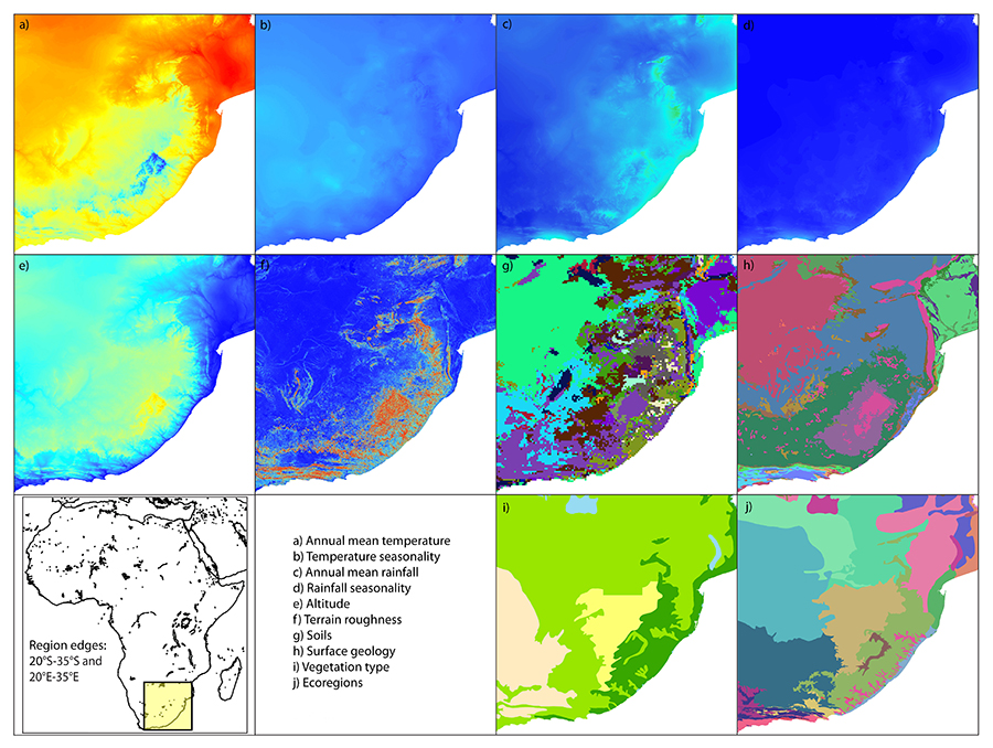
The terrain roughness map (Figure 7f) also fits rather neatly with this pattern, with the peak roughnesses also occurring in Lesotho, though high roughness values extend across a rather larger area than high altitudes (Figure 7e). To the far south, there is an area of very low altitude (blue on Figure 7e) but high roughness (red on Figure 7f), which is also reflected in the fine structure of the geological map. The soils map (Figure 7g), in contrast, shows a simpler division between complex, irregularly patterned soils to the south and on the eastern coastal plain and a large area of a single soil type in the interior that matches nicely with the underlying geology. These landscape patterns are partially reflected in the maps of vegetation and ecoregions (Figure 7i-j). In both these maps, the picture is more complex than in the physical landscape variables but does not show any clear latitudinal banding like that apparent in the west and on maps of some variables in the central region.
The climatic variables themselves (Figure 7a-d) also show little latitudinal banding, though this time – unlike what we saw in east Africa – topography seems not to be the only influence. The map of annual mean temperatures (Figure 7a), for instance, shows a fairly clear link between terrain altitude and temperature such that there are low temperatures over Lesotho and warm ones elsewhere. But the two seasonality maps (Figs 7b and 7d) instead show a coastal influence, a little like that seen on the rainfall map in west Africa and the central African maps, and the southern African rainfall map is essentially uniform across the whole 15x15 degree tile (Figure 7c). This suggests that in south Africa, as in the central region and to an even greater extent the east, we are seeing closer links between climate/ecology and terrain than in the west, though the south African maps are like the central ones in showing tectonic and coastal effects. It is perhaps worth noting that even in the west, where we saw least modification to the latitudinally banded patterns that dominated climatic maps at the continental scale, there was some increase in the influence of the physical landscape and terrain at the regional scale.
Internet Archaeology is an open access journal based in the Department of Archaeology, University of York. Except where otherwise noted, content from this work may be used under the terms of the Creative Commons Attribution 3.0 (CC BY) Unported licence, which permits unrestricted use, distribution, and reproduction in any medium, provided that attribution to the author(s), the title of the work, the Internet Archaeology journal and the relevant URL/DOI are given.
Terms and Conditions | Legal Statements | Privacy Policy | Cookies Policy | Citing Internet Archaeology
Internet Archaeology content is preserved for the long term with the Archaeology Data Service. Help sustain and support open access publication by donating to our Open Access Archaeology Fund.
File last updated: Wed Mar 4 2015