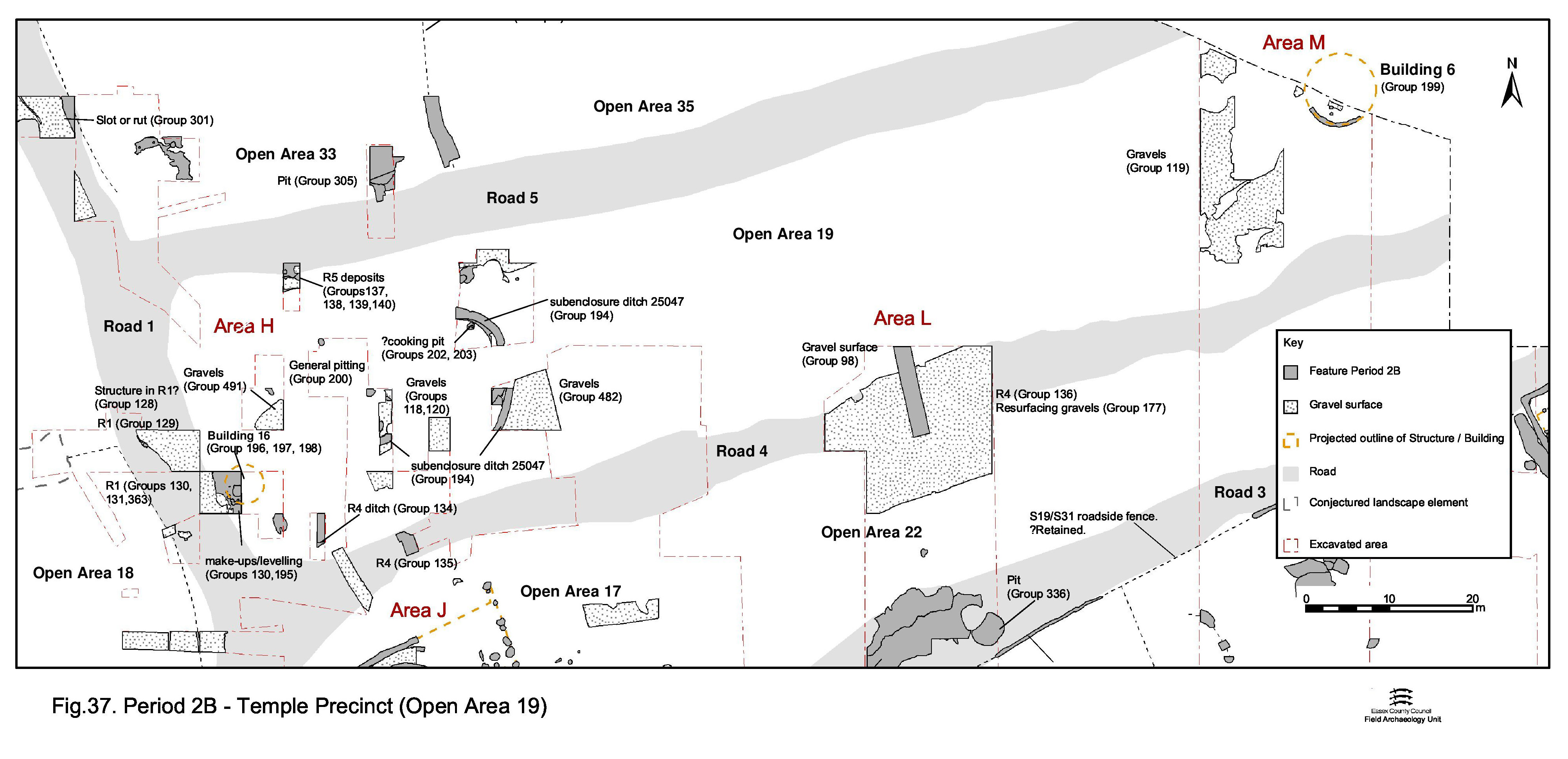
The imposition of the road infrastructure across the lower terrace results in the defining of Open Area 19 (Figure 37) - it being bounded by Roads 1, 4 and 5, so producing a long rectangular enclosure that may well taper at its eastern (uninvestigated) end. Like OAs 17 and 18, there is some evidence for levelling and infilling the vicinity prior to its interior being surfaced with gravel.
Activity within the enclosure interior appears to be concentrated at its west end, where it is most clearly bounded by Roads 1, 3 and 4 and, perhaps more significantly, the temple complex. The features relating to this activity are described below. Those of the eastern end of OA19 are described in Central zone.
Although not fully understood, the western end of the OA19 interior appears to contain a ditched oval sub-enclosure, only the eastern part of which is reliably located. The OA19 interior, both inside and out of the sub-enclosure, is surfaced with gravel and a scatter of Period 2B pits largely confined within the sub-enclosure. Building 16 stands on/alongside the Road 1 frontage, though its relationship with the sub-enclosure is unclear.
In the south-west corner of Open Area 19, perhaps preceding its creation, a series of layers (6784, 6794, 6801, 6805, 6807, 6820 Group 195) seem to constitute levelling over Period 2A waterhole 6734. It is likely they are deliberately laid for this purpose, but they might alternatively accumulate naturally in the hollow.
The earliest fragments of gravel surface (6810, 6905, 6906, 16030) and associated make-ups (6832, 6913, 6956, 6974) within OA19 (Group 118) are presumed to be contemporary with the imposition of the surrounding roads. The most extensive (and convincing) of these surface fragments (layers 6905 and 16030) can be equated with some confidence, but other gravel patches are less extensive, often uneven and difficult to match. Some parts of this surfacing episode only survive as make-up deposits, with no overlying surface remaining. Collectively, however, it is reasonably clear that these deposits represent a deliberate levelling of Open Area 19 and the provision of a metalled surface. The extent of investigation within Excavation Area H was limited and recorded areas of surfacing are consequently mainly in its southern half, but further patches are evident further north and it may reasonably be assumed that this surface originally covers the whole of the west end of OA19.
Further surfacing is present within the eastern part of the enclosure and may well be closely related (see Central zone, Open Area 19).
Further layers (6613, 6658, 6747, 6748 Group 120), which seal prehistoric deposits, are almost certainly the same surface.
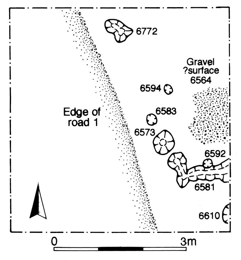
Located close to the south-west corner of OA19, directly alongside the newly formed Road 1, the partial and tentative remains of mid-1st century Building 16 consists of post-holes 6573, 6583, 6592, 6594 (Group 197) and a slot with post-setting 6581 (Group 196). These describe an arc that may mark the wall of a circular structure of c. 5m diameter (Figure 60). It is likely that further structural elements existed to the east, where excavation did not penetrate so deeply into the stratified sequence. Minor deposit of gravel 6564 (Group 198) may be a fragment of internal surfacing within this building.
Curving ditch 25047 is a tentative association of four excavated ditch segments 6377, 6566, 6849 and 16046. This feature may describe the east end of an oval enclosure seemingly occupying much of the west end of the OA19 interior. Although its full westwards extent is not determined, the enclosure may extend up to the Road 1 frontage and be open along the roadside. Re-cutting of the ditch is evident in two places (as cuts 6373 and 16041). Neither the fills of the ditch nor its re-cut offer much insight into its function, containing as they do only a small amount of pottery and animal bone. Ditch 25047 includes small amounts of pottery dating to the mid-1st century or a little earlier. The pottery from re-cut segment 16041 is similarly dated, suggesting that there is no great time difference between the cutting of the features. However, it is unclear whether or not the sub-enclosure is cut through the gravel surface of the OA19 interior, though this is perhaps likely.
The subsequent replacement of the sub-enclosure by another in Period 3 would suggest that it was an important component of OA19.
As excavated (within Excavation Area H), pits of mid-1st century AD date are mainly located towards the interior of Open Area 19, well away from the roadsides (6830, 6833, 16032, 16037, 16069, 16154 Group 200). These appear to be thinly scattered across the west end of the enclosure, in contrast to the clustering common in other parts of the Period 2B settlement. These generally oval pits are of varying size, from 1m to perhaps as much as 3m in diameter. The largest example, pit 6738 (Group 201), is cut by sub-enclosure ditch 25047 (Group 194, see below) and is only broadly dated to the Late Iron Age. As with the earlier pits in this area, the finds assemblages are both relatively small and of limited range in comparison with pits from elsewhere across the site.
Shallow pit 6478 (Group 202) is noteworthy for the incidence of eleven stake-holes (Group 203 6491, 6493, 6495, 6497, 6499, 6501, 6503, 6505, 6507, 6509 and 6511) in its base and a possible pebble lining. Four of the larger stake-holes could be interpreted to form a square arrangement in the middle of the feature, with the smaller stake-holes showing little sign of patterning around them. A function as a cooking structure is considered, but the feature contains no clear evidence of in situ burning (there is charcoal present, but nothing to indicate this was other than part of the backfill). The majority of the identified Period 2B pits are located within the enclosure (all except 16032 and perhaps16037), which may be significant.
Fragments of a resurfacing deposit (6353, 6736, 6737 Group 482, 6815 Group 491) overlie the earliest OA19 gravel surface. Although the association of these apparently similar layers, revealed within different excavated parts of Area H, is again largely tentative, the gravels of Group 482 are certainly a single surface. Deposit 6353 is of particular interest; sloping down markedly from east to west. Where it reaches the line of Period 3 ditch 25257 there is a deposit of animal bone, largely mandibles and scapulae running along the edge of the ditch. This material is incorporated into surface 6353, rather than being a compacted dump of bone upon it (which in any case could hardly have survived long in this position). This must be deliberate, and it is possible that the bone influences the later positioning of ditch 25257. The gravel patches of Group 482 also seal pit 6738 (above).
A number of isolated features are located in the limited areas of excavation within OA19 with stratigraphic positions that suggest a Period 2B date. Post-hole 6571 (Group 483) is stratified between the first sub-enclosure ditch and the overlying Period 3 resurfacing of the enclosure. Similarly, post-hole 16063 (Group 478) is sealed below a further part of this resurfacing (Group 484).
Internet Archaeology is an open access journal based in the Department of Archaeology, University of York. Except where otherwise noted, content from this work may be used under the terms of the Creative Commons Attribution 3.0 (CC BY) Unported licence, which permits unrestricted use, distribution, and reproduction in any medium, provided that attribution to the author(s), the title of the work, the Internet Archaeology journal and the relevant URL/DOI are given.
Terms and Conditions | Legal Statements | Privacy Policy | Cookies Policy | Citing Internet Archaeology
Internet Archaeology content is preserved for the long term with the Archaeology Data Service. Help sustain and support open access publication by donating to our Open Access Archaeology Fund.