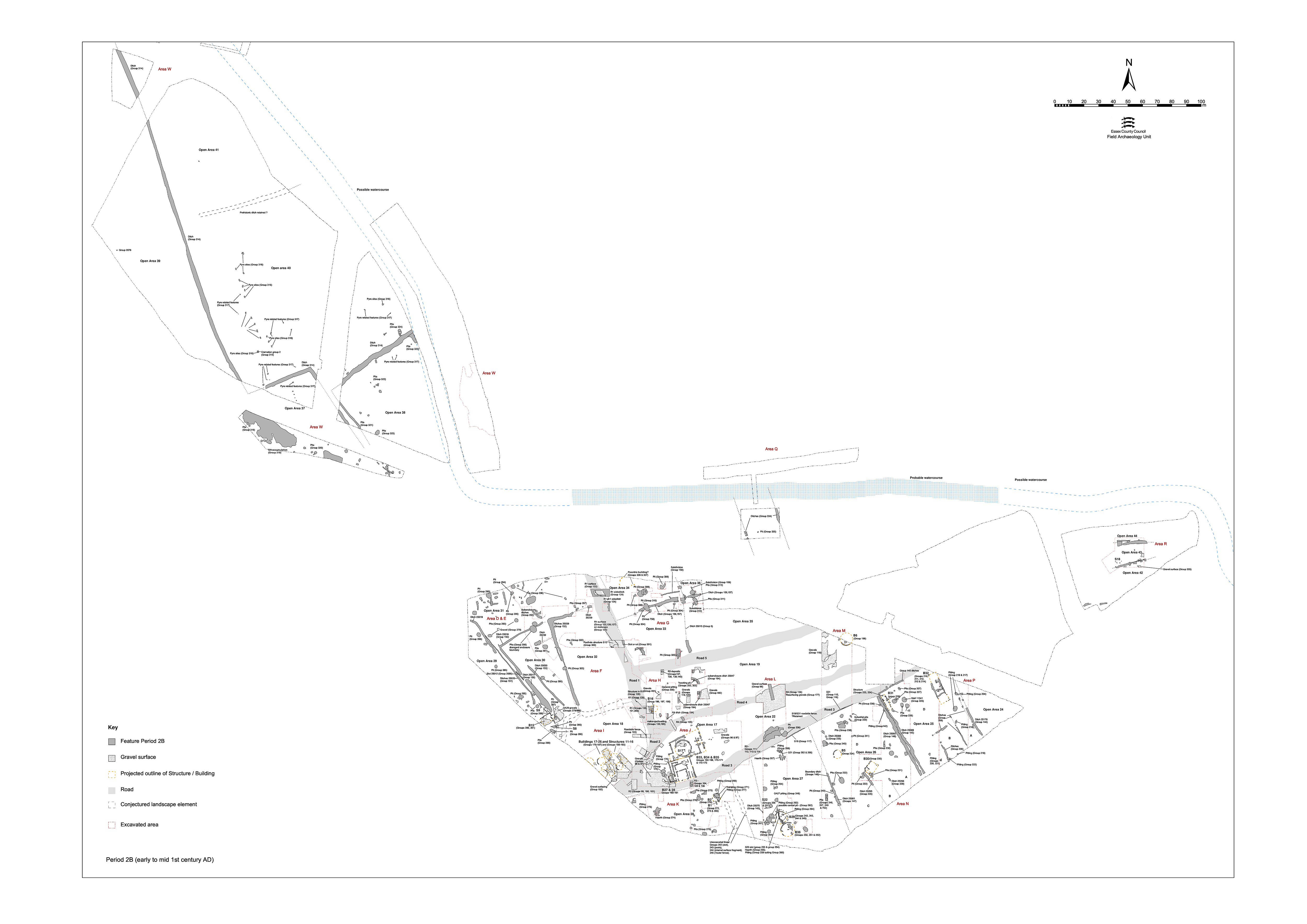
On the upper terrace, the Period 2A system of land division is replaced by a more developed enclosure system in the earlier to mid-1st century AD (Figure 51). Physically separated from the systems laid out across the lower terrace, by the terrace step and by the watercourse, it is not possible to relate this change directly with the remodelling of the settlement and imposition of the road infrastructure.
A series of ditched boundaries define a new enclosure system, the main north-south axis of which vaguely follows that of the Period 2A system.
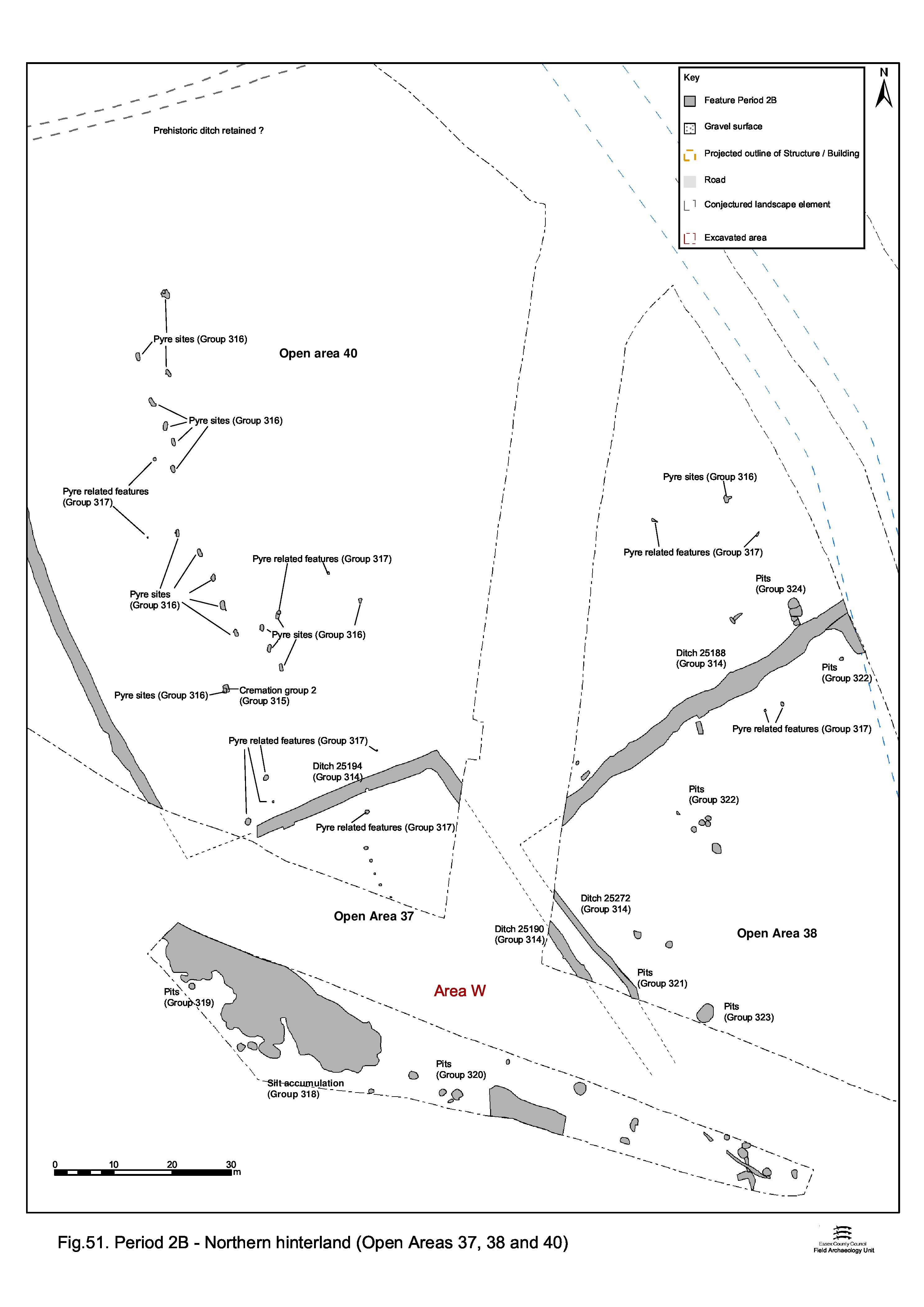
Distanced from the main settlement area on the lower terrace, the upper terrace is regarded as having an associated but distinctly different function, the various land entities defined by the ditches being far larger - perhaps constituting fields rather than enclosures. Certainly, a greater agricultural function is accorded this part of the upper terrace, as exposed within Excavation Area W, and is referenced from this point on as the Northern Hinterland zone of the settlement.
Five land entities are defined and referenced as Open Areas 37-41. While the structure of the enclosure system is covered here, the evidence for activities within OAs 37-41 is described in Northern hinterland to Eastern hinterland.
Although the Northern Hinterland zone is regarded as extending across the whole of the upper terrace, and therefore its investigated portion includes Excavation Area R north of the watercourse, no pre-Roman features are identified here. It is reasonable to assume that Period 2B features probably existed at the bottom of the Area R sequence, or had been truncated and removed by Roman period activity. Certainly, Late Iron Age features are present within the Crescent Road sites nearby.
Substantial length of ditch 25199 (segs 2336, 2400, 2539, 2864, 2935) extends across Excavation Area W for a distance of 275m, running on a roughly NNW-SSE alignment. At its north, the ditch overlies earlier, Period 2A, ditch 25102 (Group 10). Beyond the northern limit of excavation, 25199 possibly replicates the line of the earlier boundary. Southwards, however, its line progressively diverges westward from that of 25102. It is possible that its line is influenced by Bronze Age barrow 2400, which could perhaps still be visible in the landscape at this time. Ditch 25199 continues south beyond the limit of excavation but aerial photograph cropmarks show it to turn eastwards and join with ditch 25194 (below).
Ditch 25194 (segs 2192, 2924) is traced for some 48m on a perpendicular alignment to the southern course of 25199. At its eastern end it turns south and extends beyond the limit of excavation. Although the aerial photographic evidence is unclear at this point, it is postulated that it extends south to 25190. Like 25199, 25194 cuts Period 2A ditch 25102.
Ditch 25190 (segs 443, 520), 1.8m wide and 0.6m deep, is a southward continuation of 25194, presumably extending this major boundary to the edge of the upper terrace. It may also have been laid out in relation to Period 2A ring-gully 25230.
Ditch 25188 (segs 415, 496, 577, 585) comprises a 60m length on a NE-SW alignment running across the south-eastern part of Excavation Area W. Although truncated along one side by later replacement ditch 25273 (Period 3), it survives to a width of up to 1.6m and average depth of c. 0.4m. Although outside the area of excavation, the west end of 25188 is conjectured to stop short of ditch 25194/25190 and turn southward to continue as ditch 25272. Roughly perpendicular to the major north-south boundary, it forms an important, stepped, east-west boundary together with 25194. There is a suggestion of a southward return, ditch 437, at its east end - though this may rather be a Period 3 addition.
Relatively minor ditch 25272 (seg. 625) runs parallel with 25190, only c. 2-3m to its east. As the postulated southward continuation of ditch 25188, it presumably terminated at the edge of the gravel terrace. Its fill, 1.0m wide and 0.35m deep, contains burnt grog-tempered bodysherds, with adhering burnt bone.
Internet Archaeology is an open access journal based in the Department of Archaeology, University of York. Except where otherwise noted, content from this work may be used under the terms of the Creative Commons Attribution 3.0 (CC BY) Unported licence, which permits unrestricted use, distribution, and reproduction in any medium, provided that attribution to the author(s), the title of the work, the Internet Archaeology journal and the relevant URL/DOI are given.
Terms and Conditions | Legal Statements | Privacy Policy | Cookies Policy | Citing Internet Archaeology
Internet Archaeology content is preserved for the long term with the Archaeology Data Service. Help sustain and support open access publication by donating to our Open Access Archaeology Fund.