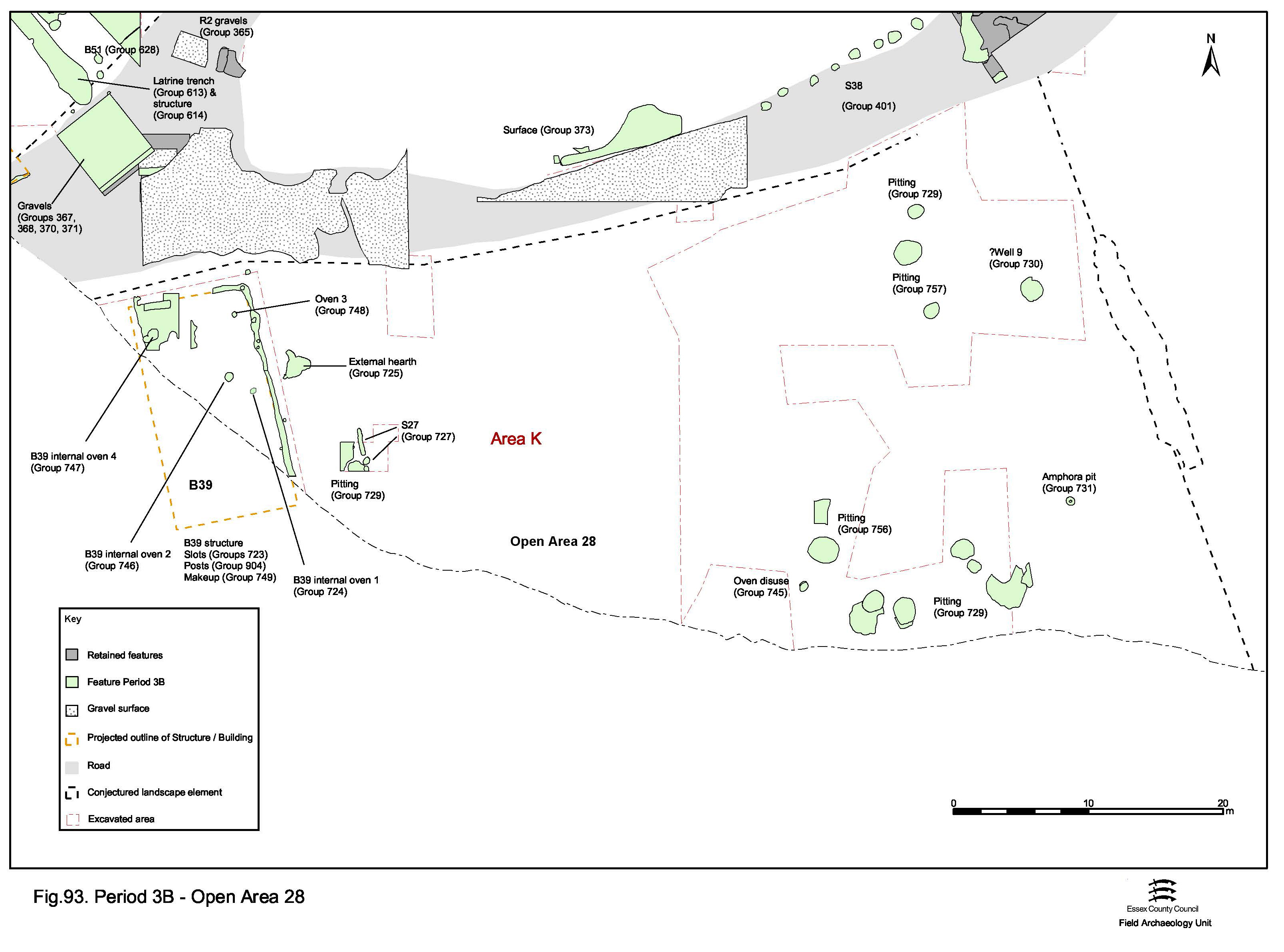
Later Period 3 features occupying the west side of OA28 have been described in the previous section. This section covers broadly contemporary (i.e. mid-2nd century) remains occupying the east side, separated by presumed enclosure subdivision Structure 27 (Figure 93). While the west side of the enclosure seems to contain primarily a domestic dwelling, the east is used for disposal, processing and perhaps manufacture.
Oven 4021 is overlain by demolition/collapse debris (4019) and dark silt infills (4033, 4034). Other than structural debris, these fills contain only small quantities of pottery and bone, which offer no insight into the function of this oven/kiln. The small amount of non-residual pottery suggests a mid-2nd century AD date for its disuse.
Feature 4536 is a 1.84m diameter cut that was only partially excavated to a depth of 0.58m. Judging from the pre-excavation planning, this apparent pit is located at the centre of a square cut, c. 2.5m across, which is filled with a deposit of red/orange clay. Although this clay was not excavated, it is possible that it constitutes the backfill of the construction cut for a well and that 'pit' 4536 is in fact the well shaft. Finds appear to have been retrieved only from the top fill 4537, the last dump into the slumping feature. These include large quantities of pottery, bone and tile, along with fragments of burnt daub, lava quern and occasional pieces of metalwork, including an iron knife blade (SF1979). Such a domestic assemblage can only reflect the well's secondary use for rubbish disposal. This infilling activity is dated to the mid- to late 2nd century AD, though an earlier Period 3 date could perhaps be presumed for its construction and use.
Technically, possible well 4536 is located in adjacent OA27, rather than in OA28. It lies slightly north-east of what is judged to be the unexcavated eastern boundary ditch of OA28, though it is unclear whether or not the boundary extends the whole depth of the plot; it is possible that it stops somewhat short of the Road 3 frontage. The well could therefore be deliberately positioned at this boundary position and be accessible as a water source from both enclosures.
Pit 4582 is a circular cut some 0.66m wide and 0.4m deep. It contains the truncated remains of an inverted Dressel 20 amphora around which is gravel, sand and clay packing deposit 4583. The feature has been truncated by machining and may have been up to 0.25m deeper originally. The vessel itself contains silt deposit 4585, which contains twenty-two iron nails, a knife blade (SF 8241) and an assemblage of assorted pottery sherds, tile and briquetage. It is likely that this fill constitutes post-use infill of the remaining void, which takes place once the inverted base is broken - if indeed the vessel is initially inserted whole. Disuse of the feature is dated by this material to the mid-2nd century AD.
It is speculated that the pit is purpose-made to accommodate the vessel, being only slightly wider than its girth and that, if inserted complete, the vessel base and spike protrudes above ground perhaps by as much as 0.3m. Such vessels have been interpreted as surveying markers elsewhere and its apparent position on the OA27/28 boundary may be significant with this in mind. This boundary, as noted elsewhere in this report, has a considerable site-wide significance, sharing an alignment with the temple precinct (OA23) front wall and, albeit seemingly only formalised in Period 4, a division imposed across OA19.
Alternatively, the amphora base may be removed in antiquity, and the modified vessel perhaps used to perform a drainage function, possibly even as a urinal as occurred at Causeway Lane, Leicester (Clark 1999). However, the vessel is not filled with a filtering deposit of cobbles or pebbles, nor are there any distinctive residues evident on its internal surfaces. The actual function of this feature therefore remains uncertain.
Although not specifically related to its use in this context, it is interesting to note the presence of an 'x'-mark on the vessel shoulder.
All but one (4726) of the mid-2nd century pits identified in OA28 are located in its eastern part. Probably the product of continuing depositional practice from Period 3A, most of these are located across the south of the plot (4008, 4010, 4044, 4048, 4137, 4211, 4247, 4752, 4973, Group 756). Pit 4973 is a northern outlier of these and 4199, 4494, 4514, 4726, 14041 (Group 757) are seemingly unplanned later Period 3 pits. From what is known of them, they seem to be similar in nature to those of Group 756.
Generally round to oval, these pits vary in size between 0.8-2.6m and depth of 0.4-1.2m. The larger examples tend to be more artefact-rich, while the fills of pits 4044 and 4752 are finds-free. Where present, assemblage composition is generally more varied than that of the Period 3A pits, with pottery and animal bone now supplemented by increasing quantities of tile and ironwork (mostly nails and miscellaneous plate and strip fragments). The incidence of three iron styli, in fills of pits 4008 (SF664), 4048 (no SF) and 4211 (SF427), is particularly noteworthy. Varying quantities of daub, loomweight, briquetage and slag remain present, but in generally small quantities and somewhat fragmentary. It is likely much of this is residual material, though the 2.2kg of daub accompanied by a piece of baked clay with copper-alloy working waste on its surface (SF 6105), ten sandstone fragments and a small quantity of slag in pit 4973 is perhaps significant.
The incidence of a probable placed deposit, denoted by a complete beaker in the top of pit 4048, is also noted.
Internet Archaeology is an open access journal based in the Department of Archaeology, University of York. Except where otherwise noted, content from this work may be used under the terms of the Creative Commons Attribution 3.0 (CC BY) Unported licence, which permits unrestricted use, distribution, and reproduction in any medium, provided that attribution to the author(s), the title of the work, the Internet Archaeology journal and the relevant URL/DOI are given.
Terms and Conditions | Legal Statements | Privacy Policy | Cookies Policy | Citing Internet Archaeology
Internet Archaeology content is preserved for the long term with the Archaeology Data Service. Help sustain and support open access publication by donating to our Open Access Archaeology Fund.