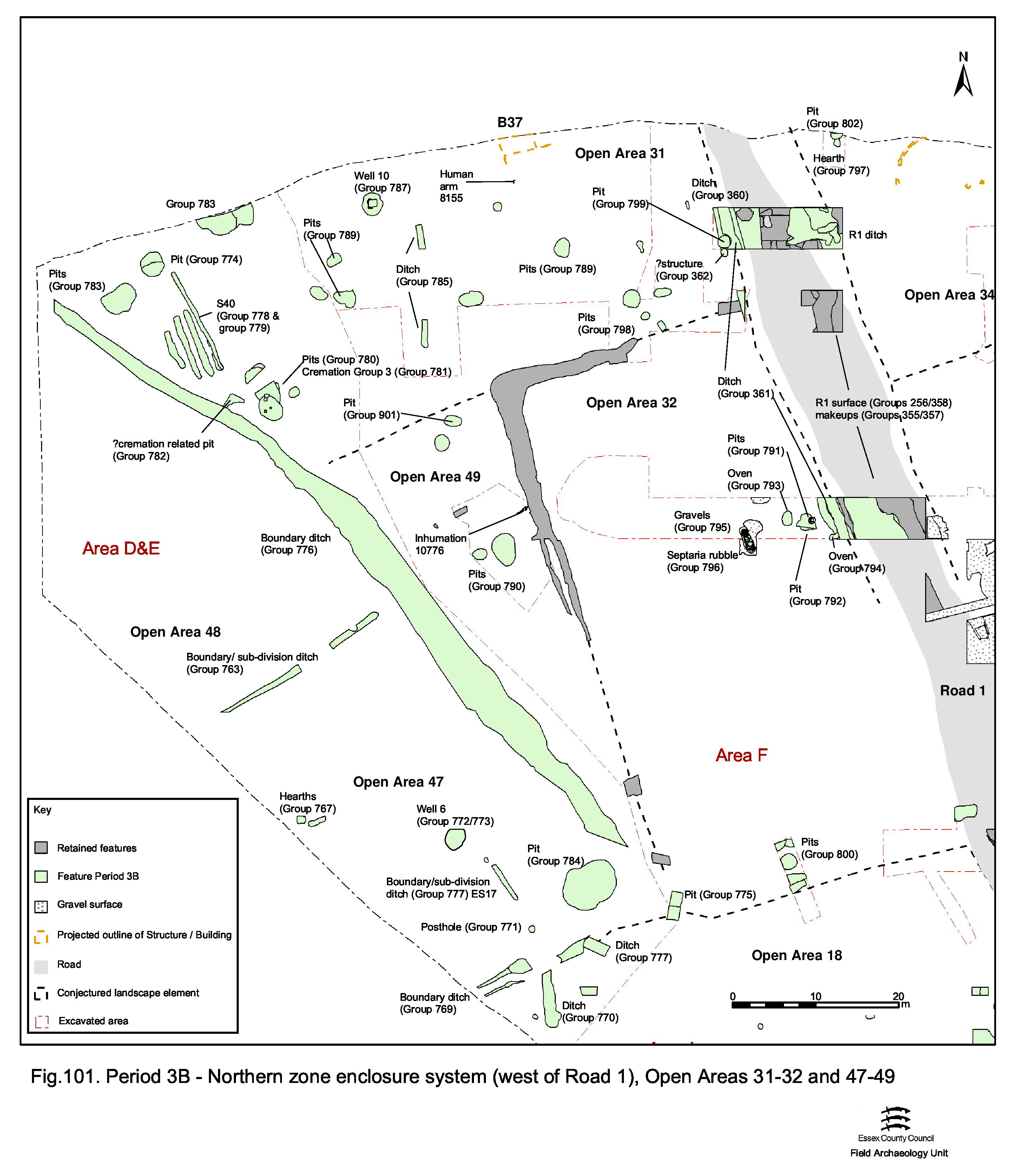
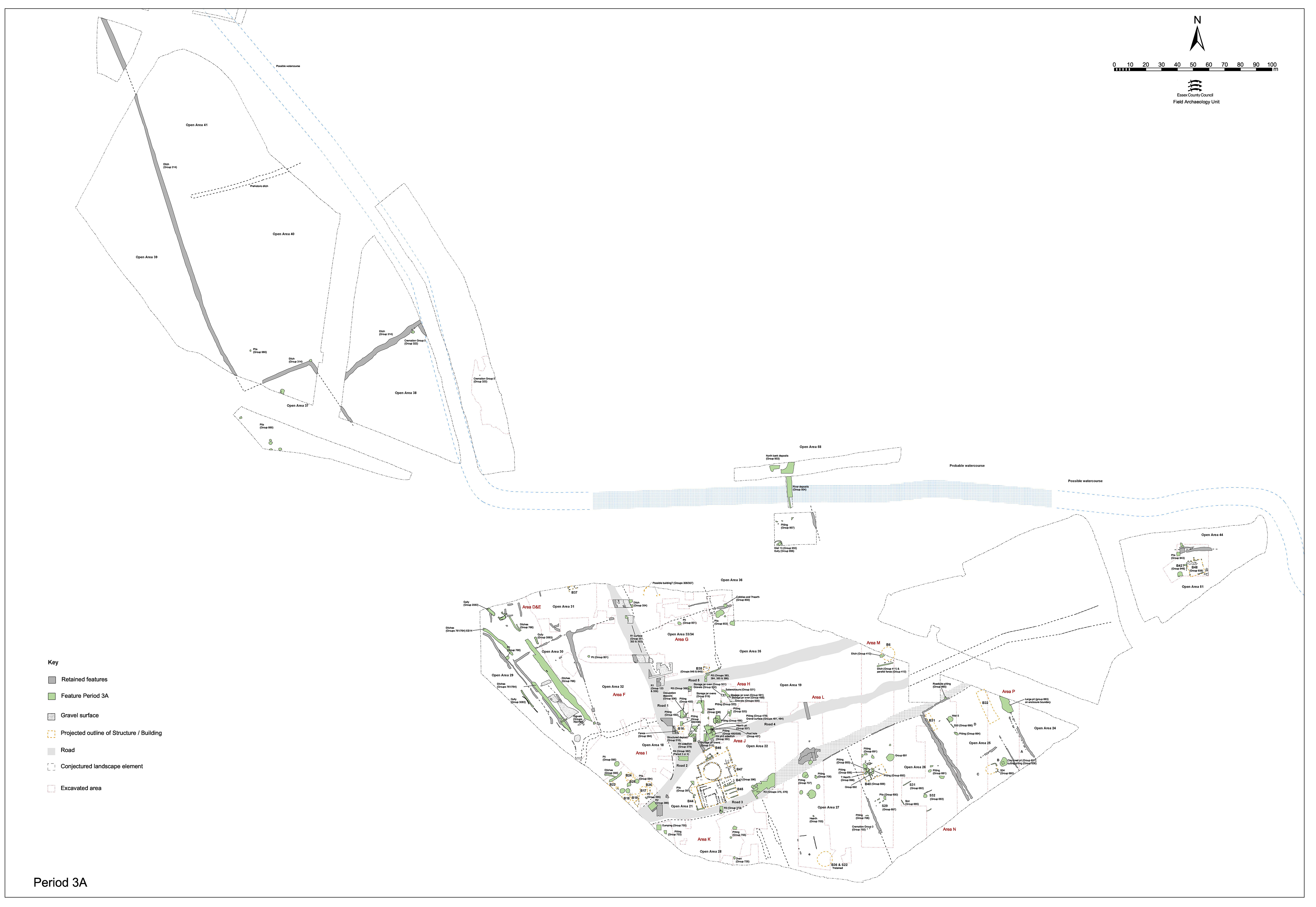
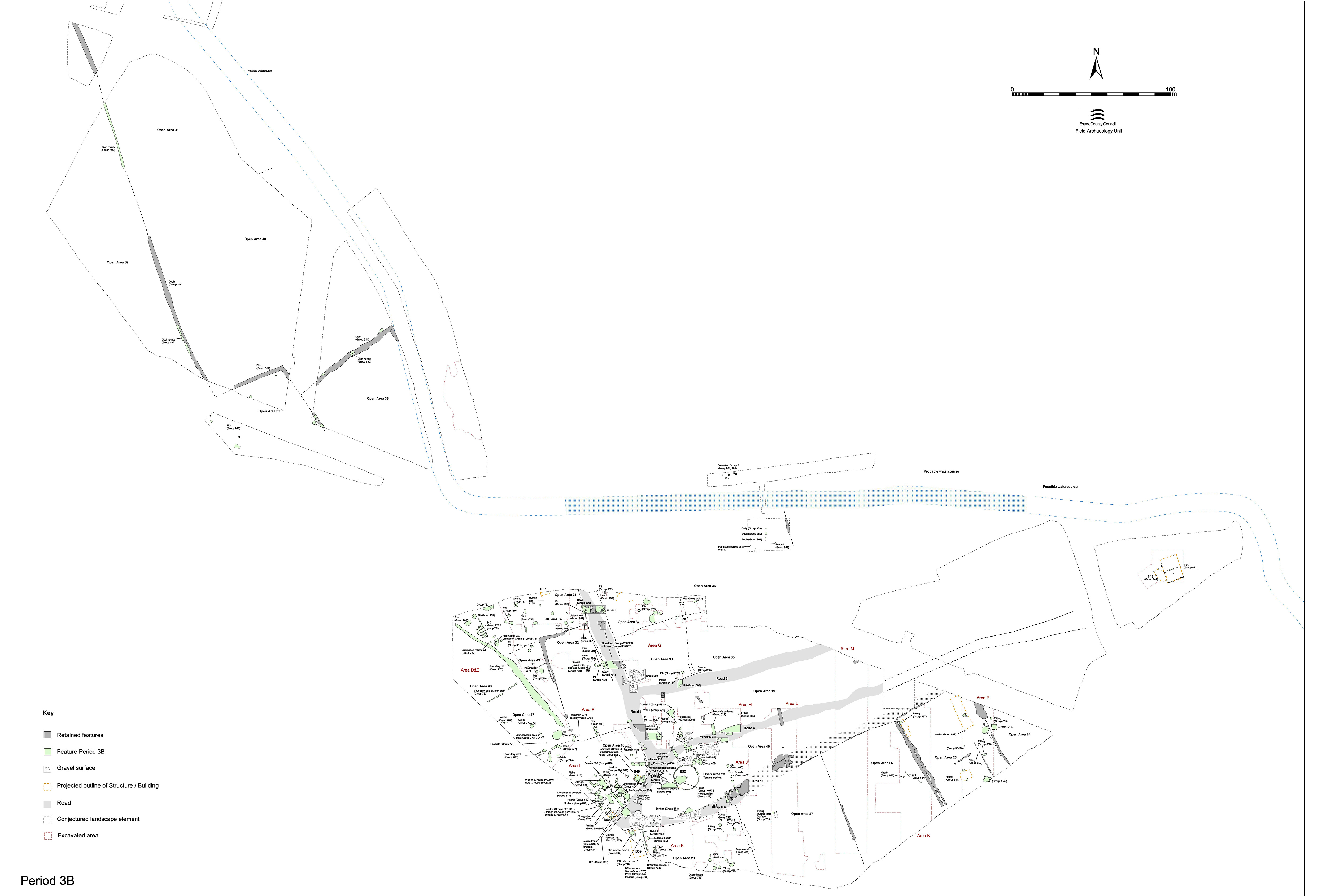
The subdivision of OA29 by the imposition of relatively minor ditch 25029 not only splits this land-use entity into two (hereafter referenced as OAs 46 and 47) but also signifies the abandonment of the Period 3A surfaced routeway (Figure 101). Ditch 25029 intrudes eastward across much of the width of the track, effectively blocking it and signalling that ditch 25028, that hitherto defines its west side, is by now defunct. However, no Period 3B features encroach upon the eastern trackside ditch 25026 and it seems likely that this boundary persists into the 2nd century - so accounting for the relative lateness of most of its fills.
Although only exposed in the very south-west investigated corner of the Northern Zone, ditches 25034 and 25035 very probably constitute the creation of a defined southern limit - perhaps for the first time. Perhaps more properly, they should be regarded as the rear boundaries of Central Zone enclosures that extend off southwards (i.e. OA18). Either way, their imposition also effectively blocks the south end of the Period 3A routeway.
With the demise of the routeway, closely associated Building 15 also passes out of use.
25029 (segs 9359, 9411) is a minor ditch which, running on a WSW-ENE alignment, is positioned at right-angles to 25026. While its westward extent is not defined, its eastern terminal allows a 4m gap between itself and the surviving boundary. With a width of only 1.0m and a depth of 0.4m, it is likely that this ditch constitutes the subdivision of the large enclosure lying to the west of 25026 (OA29).
25034 (segs 9700, 9709, 9888, 9741) is the rounded terminal of a NE-SW aligned ditch, largely removed by Period 5-6 replacement ditch 25031. It is cut through Period 2B gravel surface 9589 and removes all traces of the south side of the Building 15 - which has by now evidently been removed. The ditch terminus was originally identified in the field as being truncated by pit 9741/9888, but this pit is itself probably a misinterpreted part of the terminal, with the re-cutting constituting subsequent cleaning and maintenance.
Along with ditch 25035, 25034 presumably extends westwards to form the boundary between newly created OA47 and undefined enclosures of the Central Zone.
Ditch 25035 (segs 9581, 9606, 9648) is a shallow curving gully/ditch directly to the east of 25034. It is traced for c. 12m, rising up to a broad, shallow terminal at its south end, but all trace of its further eastward course is removed by its Period 3C replacement, ditch 25015.
Curiously, this ditch corners on the same alignment as ditch 25028, forming what could be construed as an 8m-wide entrance between them. Within this gap, post-hole 9606 (Group 771) is tentatively identified as being a part of this entrance. It stands out as a large and otherwise isolated structural feature equidistant between the two ditches and it is possible that these are contemporary for a while, before 25028 passes out of use. Ditch 25035 is essentially an eastward continuation of the same boundary as ditch 25034. Together, they define a 2m-wide gap where once would have been a wider entrance onto the routeway to their north. The shallow curving terminal of 25035 may function as a funnelling device, controlling the passage of livestock between the enclosures on either side.
It is postulated that 25035 originally extends eastwards, possibly as far as Road 1, forming the south side of OA32, which lay to the east of 25028, but which is largely removed by its Periods 3C-4 successor boundary 25015.
OA47 is that part of the former OA29 interior to the south of ditch 25029 (Figure 101). Building 15 passes out of use by Period 3B, the new southern enclosure ditch 25034 removing its entire south wall. Despite the demise of this focus of occupation, it is possible that another dwelling occupies another part of the plot, as suggested by the appearance of well 9421 (though this could equally be used for the watering of livestock held in these enclosures).

9421 is the 2.7 x 2.4m, slightly oval, construction cut of a timber-lined well. It is cut through the fills of ditches 25017 and 25028 to a depth of c. 1.97m (reaching 0.81m OD). A simple timber box-lining, a little under 1.0m square, is centrally located in the cut and clean blue-grey clay 9887 used as packing around it (Figure 126). The well lining, constructed of tangentially sawn oak boards jointed with single dovetails, survives to a height of five courses. A dendrochronological date range for the felling of timbers in this structure of AD 135-6 was obtained. The well fills (Group 773) signifying disuse are sufficiently later in date to be discussed separately.
Two hearths and storage jar oven 9573, occupy the OA47 interior. A further storage jar oven 9506 technically lies outside (once the 25034/35 boundary is in place) but is included here for thoroughness. Although these features cannot be closely dated in their own right, elsewhere within the settlement most hearths (where dated), and virtually all storage jar ovens, tend to be of this late 1st to early 2nd century date (e.g. OA18 and 19 ovens).
Burnt deposit 9369 is a collection of cracked and reddened stones on top of the brickearth. Not obviously in a cut, they could conceivably line the bottom of a hearth pit that has been severely truncated. 9404 is a similar burnt flint feature, but is contained within a very shallow cut.
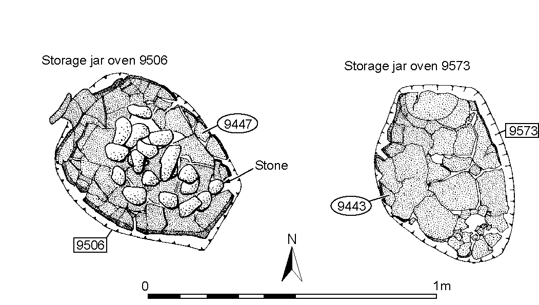
9506 is a storage jar oven, the jar of which (9447) contains stones that may indicate a hot-stone method of cooking is used (Figure 127). 9573 is a similar storage jar oven, minus the stones. Although not obviously associated with anything else, it is cut into the top of by now defunct ditch 25028, and so must be late 1st century or later. It is possible that these cooking structures infer a degree of domestic activity taking place in OA47, particularly with oven 9573 being located close to well 6.
OA48 (Figure 101) is that part of the former OA29 interior to the north of ditch 25029. It is presumed that ditch 25018, which until now marks the west side of the routeway, is short-lived. Certainly, it seems to be infilled in the third quarter of the 1st century AD. It is therefore presumed that the trackway itself is incorporated into the enclosure, its eastern boundary now being marked by ditches 25026 and, possibly, 25006. No Period 3B features have been identified to occupy the OA48 interior. Given its relatively slight boundary with OA47, it is possible that it merely functions as a field alongside, and attached to, an occupation area.
Nothing obviously attributable to the early 2nd century occupies the interior of OA49 (Figure 101), its encroachment in Period 3A by a new routeway perhaps signalling abandonment or change of use.
Few pits attributable to Period 3B have been identified within OA31 (Figure 101). Indeed, to some extent these may be interchangeable with those of Periods 3A and 3C.
Pit 9044 (Group 774) is a roughly circular cut of 3m diameter and 0.4m depth, with steep sides and a flat base. Its single fill contains small quantities of pottery, tile and animal bone. It is possible that it is deliberately located off the end of contemporary ditch 25026 and could be variously regarded as falling within the OA31 interior, on its western boundary, or outside (in OA48?).
Located in the south-east corner of OA31, pits 10110, 10113, 10119 and 10133 (Group 798), give no meaningful insight into the overall distribution of such features within this enclosure, but may hint that there is a degree of continuity of location in relation to the Period 2B pits that are positioned at the terminal of enclosure ditch 25039.
Early Roman post-hole 10132 (Group 362) is cut into the fill of defunct roadside ditch 25244/25245. It contains a post-pipe and is an indication that some sort of structure is present alongside Road 1 at this time - though it is conceded that it could simply be part of a fence replacing the ditch.
As ever, the limited nature of investigation carried out across the OA32 interior precludes any meaningful insight into its nature and development at this time (Figure 101).
In the Excavation Area F 'North Trench', oval pits 10322 (Group 792), 10349 and 10371 (Group 791), all of early Roman date, are positioned within 10m of Road 1. These seem to be filled with domestic rubbish. Both pits 10322 and 10349 are perhaps noteworthy owing to their unusually diverse assemblage for ?mid/late 1st century Roman features. As well as pottery, animal bone, tile and daub, 10322 also includes copper-alloy cast waste and box fitting sheet (both SF3496?), iron double spiked loop (SF3499), a wool-comb (SF3492) and a number of nails. Pit 10349 includes copper-alloy ring (SF4014) and finger ring (SF4000), iron sheet fragment (SF8287) and nails, and also a bone dice (SF6574) and lava quern fragments.
Pits 10531, 10532 and 10398 (Group 800) are located on the southern boundary of OA32. Their distribution is again not particularly instructive, as this merely reflects where excavation of the boundary ditch and its immediate vicinity was carried out. In comparison with those further north, the artefactual content of these pits seems less varied; largely comprising pottery together with tile, animal bone and baked clay fragments.
Pit 9774 (Group 775) is located on the projected boundary line between 32 and 49.
10501 is a shallow cut containing the truncated remains of two large storage jars (10388 and 10399) laid one on top of the other. Both jars contain the remnants of charcoal-rich fills, which include large, often burnt, flint pebbles. The interiors of the two vessels are themselves burnt and are interpreted as the remains of successive storage jar ovens, the use of which span the late 1st to early 2nd centuries AD.
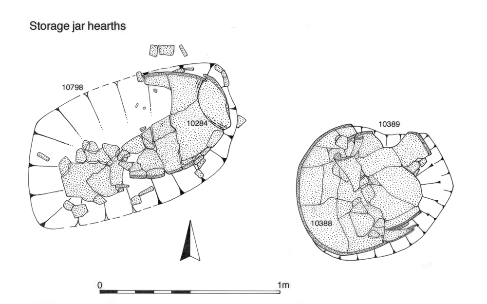
Hearth 10798 is a similar arrangement of successive storage jars (10253 and 10284), set in an irregular, 0.2m deep cut (Figure 128). In this instance, the fills show no particular sign of in situ burning. It is positioned on the edge of Road 1 itself, only 3m to the south-east of hearth 10501.
Gravelly layers 10350 and 10358 (Group 795) lie in close proximity to the ovens and pits within the Area F 'North Trench' and may represent the remains of an associated surface. Together, the presence of these features may suggest occupation within OA32 is focused along the Road 1 frontage.
Internet Archaeology is an open access journal based in the Department of Archaeology, University of York. Except where otherwise noted, content from this work may be used under the terms of the Creative Commons Attribution 3.0 (CC BY) Unported licence, which permits unrestricted use, distribution, and reproduction in any medium, provided that attribution to the author(s), the title of the work, the Internet Archaeology journal and the relevant URL/DOI are given.
Terms and Conditions | Legal Statements | Privacy Policy | Cookies Policy | Citing Internet Archaeology
Internet Archaeology content is preserved for the long term with the Archaeology Data Service. Help sustain and support open access publication by donating to our Open Access Archaeology Fund.