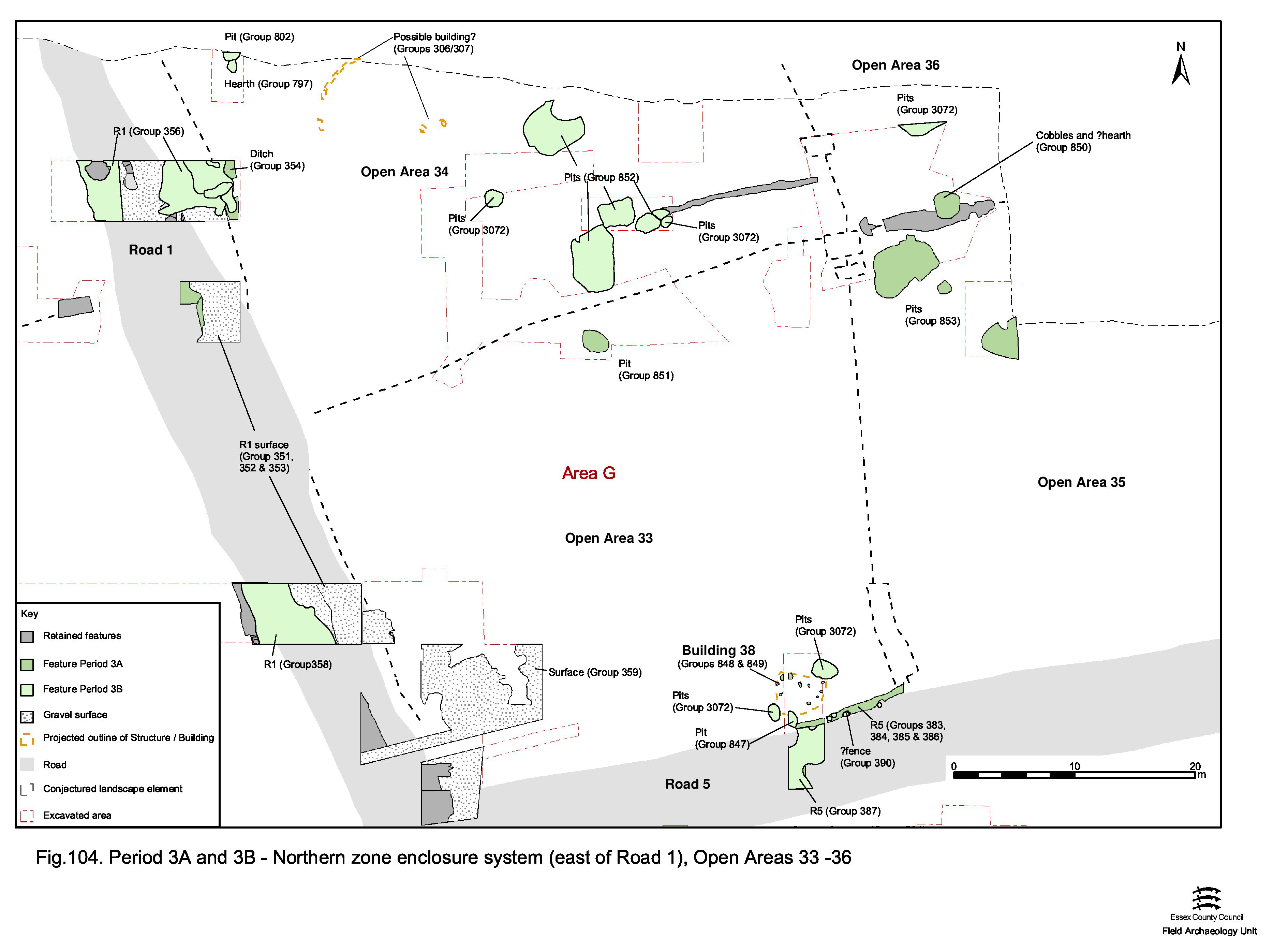
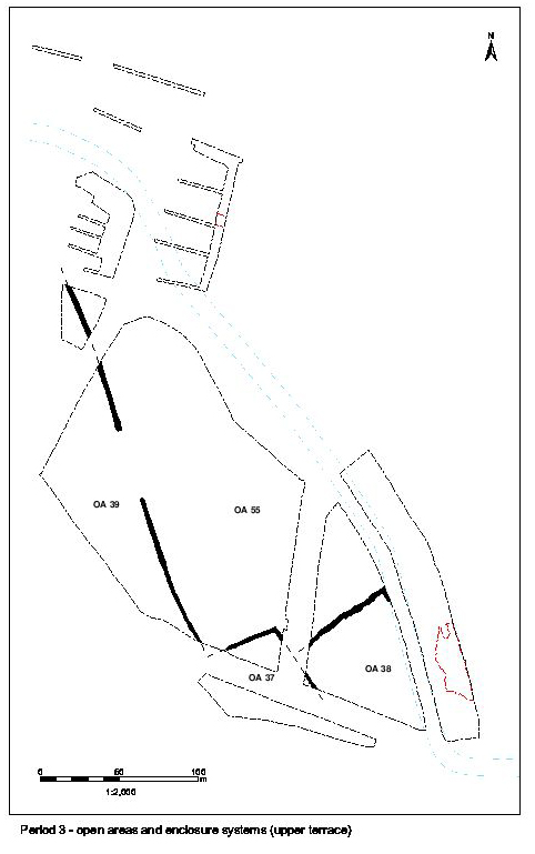
Only the immediate south-west and north-east corners of OA36 are exposed (Figure 104), where investigated within Excavation Areas G and R respectively. While little can be deduced from the single pit and possible gravel surface occupying the south-east, the northern periphery can be demonstrated to be well defined. A series of broadly parallel ditches and gullies indicate the presence of drains and boundary features alongside the southern edge of the watercourse. The presence of pits and a well suggest occupation activity extending the whole depth of the enclosure.
Gravel deposit 7059 is an isolated spread in the north-east of Excavation Area G - in the perceived south-western corner of OA36. While it overlies Period 2B ditch 25042, and contains early Roman material, this deposit is unlikely to be an outlying fragment of the surfacing alongside the Road 1/5 junction, though it could conceivably be contemporary. Although direct dating evidence for this surfacing episode is minimal, stratigraphically it must fall into the second half of the 1st century. This deposit at least serves to show that sporadic surfaces occur across the plot interiors in this part of the settlement; although, in this case, it is not possible to determine what 7059 is associated with.
Partially exposed pit 7341 (Group 3072) is accorded only a general Roman date on the basis of its artefact assemblage, but is likely to be early Roman. Probably large and sub-circular, a small quantity of pottery, tile and baked clay is present in its fills.
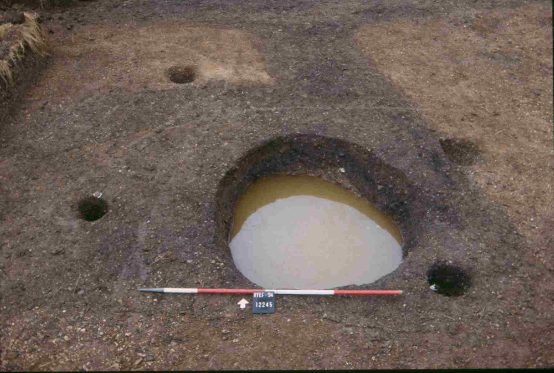
Circular feature 12245, located in that part of OA36 investigated within Excavation Area R, south of the watercourse, is most probably the construction cut for a well (Figure 106). The 2.0m-diameter cut is not fully excavated, but investigation to a depth of 0.75m reveals near-vertical sides, cut through Period 2 ditch 12284 and into the underlying natural brickearth. Its upper part is filled with a brownish-grey sandy silt. Although excavated to just below the modern water-table (c. 1.70m OD), no waterlogged deposits or internal wooden structures are encountered. This upper fill includes quantities of pottery, tile and animal bone, together with lead fragments and weights (SFs 6361, 6362) and an illegible sestertius (SF6384). While it is possible that this feature is constructed as early as the end of Period 2B, it is clear that the well passes out of use sometime in the 2nd century AD. However, its depth seems to promote slumping of the infill deposits and it is suspected that, owing to the presence of both late Roman and early Saxon pottery, a later slump accumulation deposit was not recognised in the field.
Semi-circular gullies 12274 and 12276 are in close association with well 12245. Unexcavated, they are recorded as two conjoining lengths of curving gully or slot; it is more likely that they constituted a single cut, 25269, perhaps with a variable fill. As such, they form a half-circle around the north and east of the well and are postulated to be the foundation cut of a wooden structure around it and to be contemporary with its early use. Whether this structure is walled and roofed, or merely a protective fence, is unknown. Apparent replacement by a Period 3B post-built structure would suggest that it dates to the mid- to late 1st century AD.
Only a small number of early Roman pits are recognised in Excavation Area R south of the watercourse. It is possible that more lie concealed below the thin gravelly silt layer 12267. It is perhaps significant that no pits post-dating the early Roman period are found beneath the gravel spread, where removed, or north of early Roman ditches 12291 and 12236 (see below). This suggests these ditches define a tangible boundary alongside the watercourse. Pits 12293 and 12311 contain small amounts of tile and bone, as well as pottery of late 1st to early 2nd century AD date. Pits 12278 and 12282 pre-date Well 13, the latter also post-dating Period 2 ditch 12284. Collectively, these pits demonstrate that settlement activity extends virtually right up to the edge of the watercourse during this period.
Small ditch/gully 12309 is only revealed in a machine-cut section across Excavation Area R, south of the watercourse, it being masked by the same overlying homogeneous gravelly silts, 12267, as obscure the pitting. Running on a NE-SW alignment, this linear feature has a U-shaped profile, 0.6m wide and 0.4m deep. It runs roughly parallel to the watercourse and appears to be of late 1st to early 2nd century AD date, cutting across the top of infilled Period 3 pit 12293 (Group 957).
Ditch/gully 12291 is similarly only recorded in section. Although established to be a linear feature, some 1.2m wide and only 0.16m deep, its line can only be approximated. It is assumed to run broadly parallel with the south side of the watercourse, along with the other Period 3 ditches, 12236 and 12299, to its south. A small amount of tile and pottery are collected from its fill, though the latter only gives a general early Roman date.
Again, observed and recorded only in section, this 1.5m wide and 0.6m deep linear cut runs broadly parallel to the watercourse and to the other Period 3 ditches 12291 and 12299 to either side. Its extent beyond the section trench can only be surmised. This relatively substantial ditch contains a lower, gradual silting, fill which includes mid-2nd century pottery and an upper backfill of early 3rd century date. Thus, this ditch appears to have a prolonged use into Period 4. The finds assemblage, with its modest quantities of pottery, tile animal bone and ironwork seems consistent with this date range and may suggest deposition of domestic rubbish. Its mid-Roman filling includes window and vessel glass too. The presence of an iron scythe blade (SF4824) is perhaps notable.
Linear feature 12299 clearly comprises two cuts with indistinguishable fills, presumably one a re-cut of the other. Each is around 1.5m wide and 0.5 to 0.6m deep, similar to ditch 12236 (Group 960) only a few metres to the north. Only recorded in section, it is again postulated to run parallel to the watercourse and the other Period 3 ditches, 12291 and 12299, to its north. No finds are retrieved from its fill, though it is sealed by Period 4 deposit 12267.
Four broadly similar post-holes occur in the immediate vicinity of well 12245. They are speculated to denote parts of a roughly rectangular structure that stands over the well. Post-hole 12243 cuts the foundation gully 25269 (Group 956), indicating that this most likely replaces the earlier circular structure around the well.
A row of three substantial post-holes runs to the east of Well 13. All are oval, between 0.4 to 0.6m wide and of similar depth. Cut 12227 contains evidence of in situ burning. All contain early Roman pottery. Together they define an ENE-WSW alignment parallel with the Period 3 ditches to their north. Other, unexcavated, post-holes are recorded on the pre-excavation plan for this area and could conceivably be parts of the same, undefined, structure. Whether these constitute part of a building, enclosure or simple fenceline alongside the watercourse is unclear.
Internet Archaeology is an open access journal based in the Department of Archaeology, University of York. Except where otherwise noted, content from this work may be used under the terms of the Creative Commons Attribution 3.0 (CC BY) Unported licence, which permits unrestricted use, distribution, and reproduction in any medium, provided that attribution to the author(s), the title of the work, the Internet Archaeology journal and the relevant URL/DOI are given.
Terms and Conditions | Legal Statements | Privacy Policy | Cookies Policy | Citing Internet Archaeology
Internet Archaeology content is preserved for the long term with the Archaeology Data Service. Help sustain and support open access publication by donating to our Open Access Archaeology Fund.