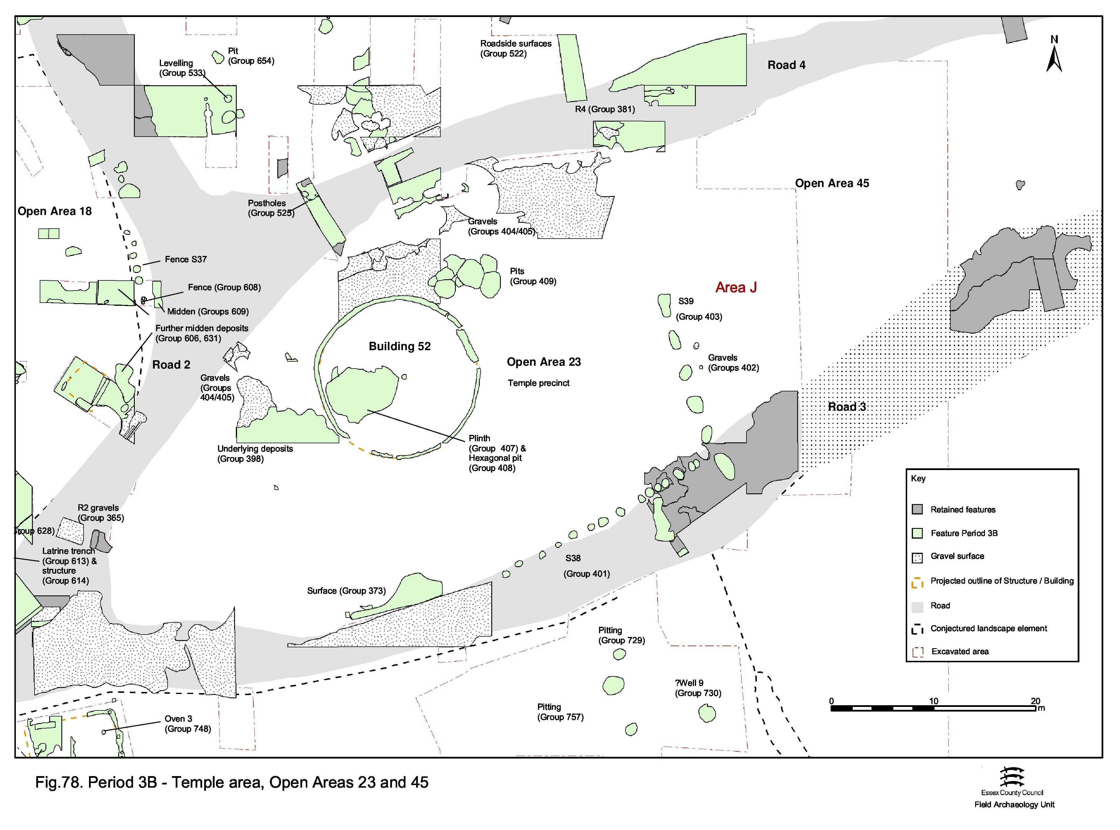
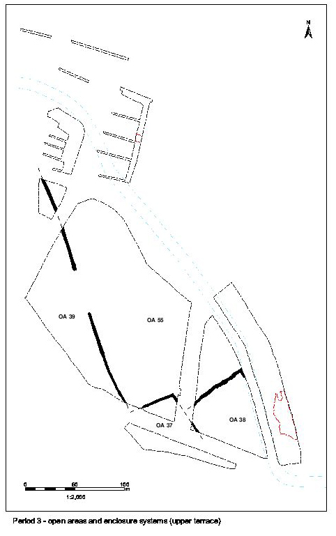
Formerly considered to be part of OA21 through Periods 2B and 3A, the imposition of a clear physical and functional division of the land entity defined by Roads 2, 3 and 4 into two necessitates separate referencing when describing Period 3B development and change. Open Area 23 henceforth describes the western end of former OA21, west of the newly created temple frontage wall (see Structure 39 below), encompassing the temple buildings complex.
Accompanying this division, the Period 2B/3A temple complex is entirely demolished and a new, slightly larger, circular temple constructed over its predecessor Building 34. The new temple stands in splendid isolation, unaccompanied by ancillary buildings or other upstanding structures (Figure 78). However, for the first time, the religious precinct is formally enclosed - at least on two sides - by a fenceline alongside Road 3 (Structure 38) and a substantial screening wall across its eastern 'front' (Structure 39).
Structural change is clearly wholesale and dramatic. Change of use within the newly created OA23, perhaps even of religious practice, is signalled and can be discerned in the differing location and nature of temple-related disposal/deposition, as well as in the simplified form of the temple complex itself.
Layers of brown sand-silts (Group 398) accumulate on top of the gravel surface in the western part of the temple precinct, to the rear of the various buildings. These are not extensive, nor necessarily associated with one another, and may merely be accumulations in slight hollows and depressions in the surface across the temple area - they do at least show that this area of the precinct yard is not kept particularly clean. Some of these deposits are notable for their relatively high finds content; the assemblage from 5810, for example, is comparable in volume to those from some of the contemporary pits. This pottery, and that from deposits 5807 and 5859, is noticeably broken, as might be expected if it was subject to trampling underfoot, and may indicate that these deposits relate directly to the earlier 2nd century use of the temple precinct. Some of these layers are not effectively 'sealed' by later deposits. As is often the case, the pottery from these deposits comprises a mixture of contemporary material, dating to the late 1st to mid-2nd centuries, and intrusive material (e.g. from 5807), deposited long after the soils themselves and indeed after the area had passed out of use.
It is unclear whether these layers represent a Period 3A or a Period 3B activity. Although no relationship is recorded, it is likely that these silt deposits seal pit 13892 (Group 397). More certainly, they overlie those parts of Building 35 that define its possible eastern porch (i.e. 13489, 13447). This may either imply a modification to the rear entrance to Building 35 or may post-date the building entirely. The new temple, Building 52 (Period 3B), overlies at least two of the deposits within the group.
Further layers of silt (18832, 18869, 21549, 21632, 21634, 21645, 21991 Group 402) lie on the eastern side of the precinct and extend eastwards into the 'open space' beyond it. These lie on the earlier (Period 2B/3A) gravel surface and are in turn overlain by another gravel surfacing (21591, 21631, 21962 Group 402). It is uncertain whether the find-free silts represent occupation build-up or a deliberate make-up for the new surface, though the absence of intervening features between them and the overlying surface may suggest the latter. This suggests that there is little or no formal division or distinction made between the temple complex and the open space to its east prior to the imposition of precinct wall Structure 39.
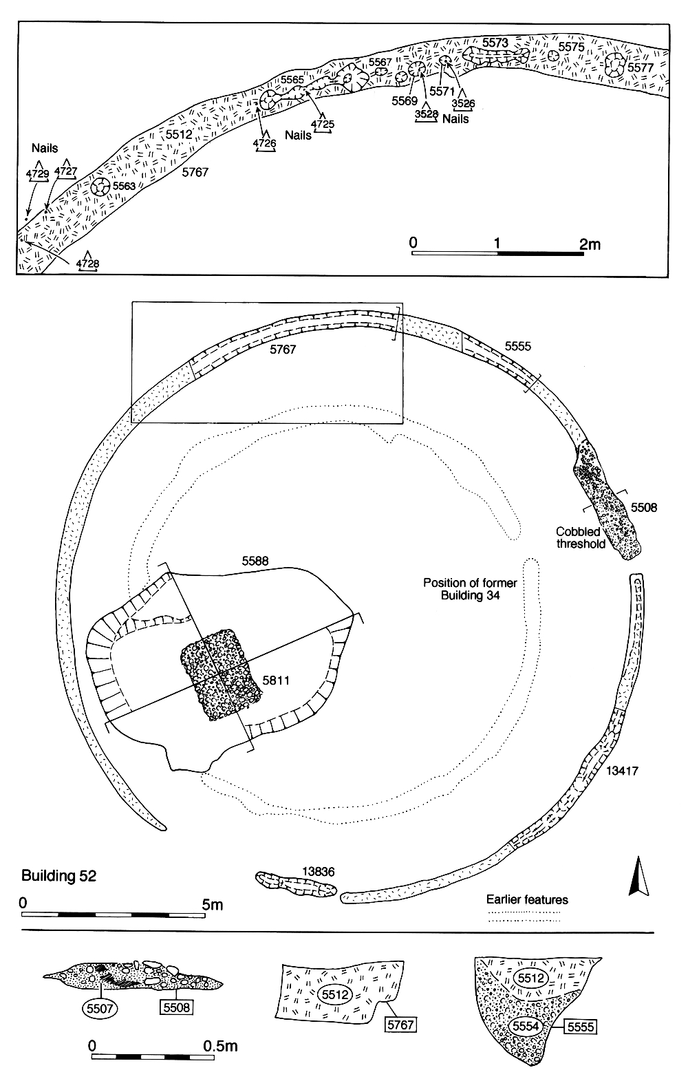
Building 52 (Group 406), the second phase of temple cella (Figure 79), is denoted by circular foundation slot 25056 (segs 5508, 5513, 5555, 5563, 5565, 5567, 5569, 5571, 5573, 5575, 5577, 5767, 13417, 13836) describing a structure some 15.7m in diameter (14.6m internally). The slot itself is 0.45m wide and up to 0.33m deep, filled with a distinctive orange-brown clay. This is a packing deposit around a series of upright posts, the positions of which are evident in the base of the slot. The presence of iron nails, particularly in slot segment 5555, where they appear to form a linear distribution (SFs 4725-4731), gives further insight into the construction of this building and confirms the undisturbed nature of these foundation remains. The clay-filled foundation is interrupted by a short length of wider slot 5508, packed with mortared septaria rubble and gravel. This is located on the ENE side of the building and is clearly the remains of the threshold of a c. 3m-wide doorway. The foundation slot is also interrupted on the south-west side of the building, although it is less clear whether this necessarily constituted a further entrance - the foundation slot is so shallow here (c. 20mm) that the apparent gap may simply be a product of truncation.
Although Building 52 is near enough concentrically positioned around Building 34, it is unlikely that the two standing structures were ever contemporary. Building 52 overlies the foundations of the trapezoid enclosure (Building 35) associated with the earlier temple. However, the approximate concentricity of Buildings 34 and 52, and the common alignment of their entranceways, does suggest that the new building is constructed with specific reference to its predecessor. It is even possible that, despite the demolition of the trapezoid enclosure (Building 35), the earlier cella remains and Building 52 is constructed around it. If so, Building 34 need not be removed until the insertion of pit 5588 (Group 408), sometime later in Period 3B. As is the case for Building 34, no evidence of internal roof supports can be discerned within Building 52, though a number of other interior features are present and are described below.
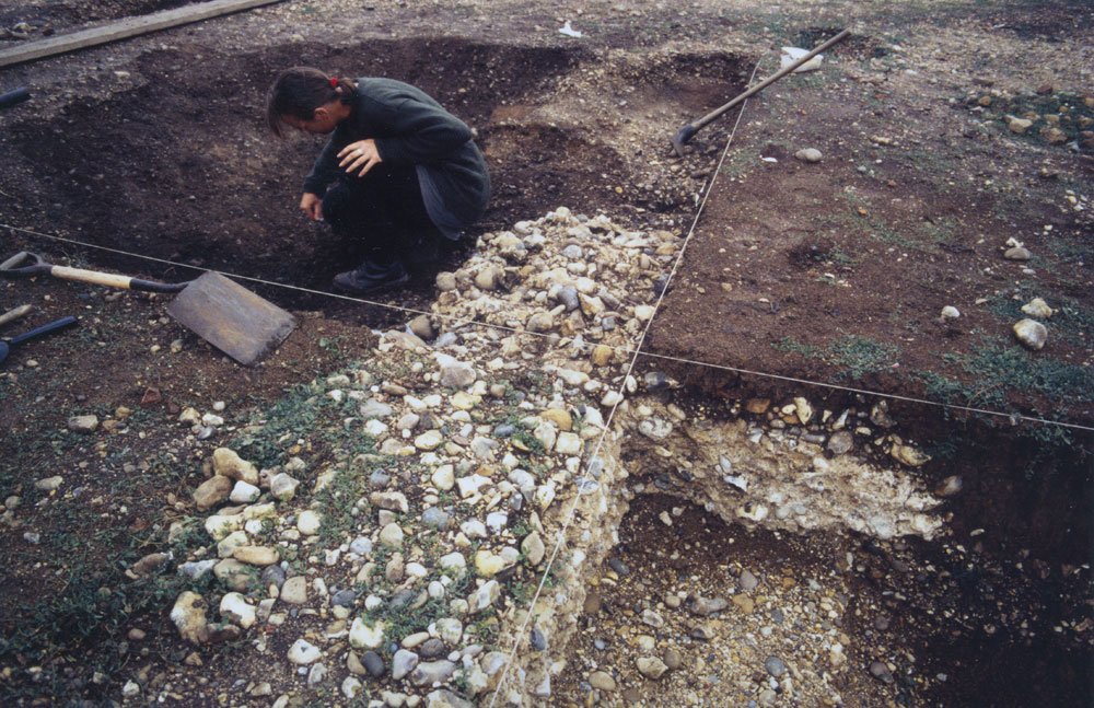
Plinth 5811/13520 (Group 407) is a rectangular block of mortared, un-coursed flint-and-septaria rubble (Figure 80) positioned at the centre of pit 5588/13432 (Group 408 see below), within the interior of temple cella Building 52 (Figure 79). However, it is unlikely that this structure is placed in the pit, either when open or backfilled - it is more likely that the plinth pre-dates the construction of the pit.
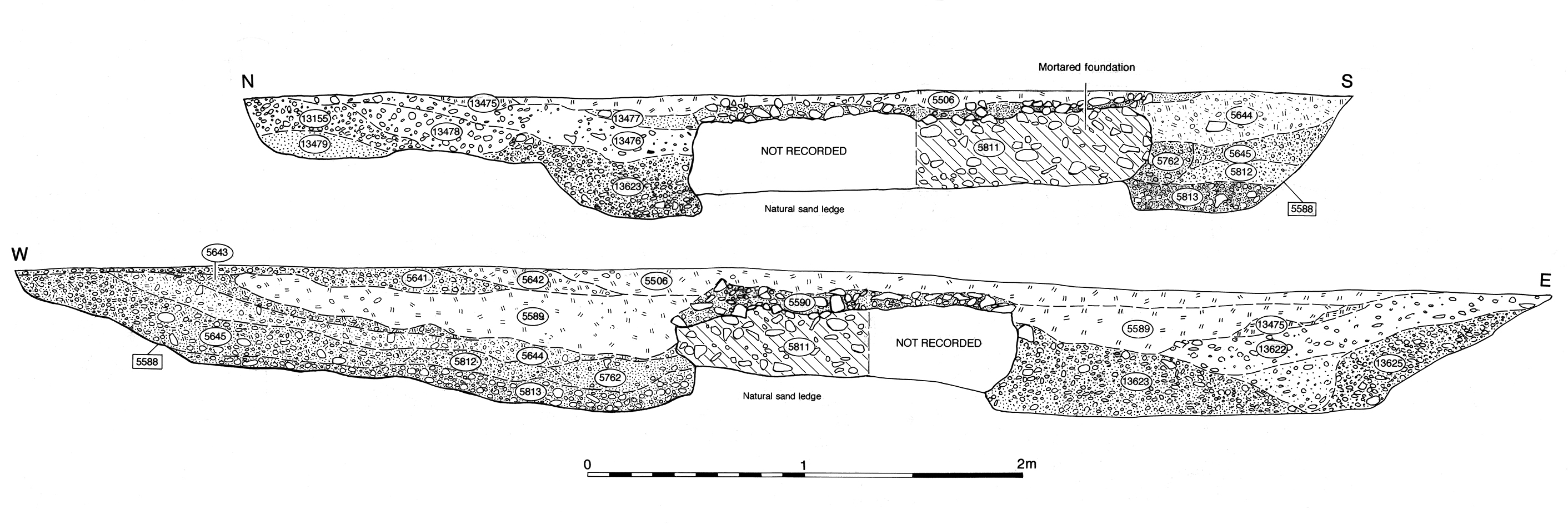
The plinth measures 1.6m by 2.2m and, judging by the rough, unfinished, nature of its vertical faces, originally occupied a construction cut probably made straight into natural gravel. The plinth survives only as a 0.35m-deep foundation, any above-ground portion it once had being demolished in Period 4, so that only its foundation remains below the contemporary floor surface (Figure 112).
Such a solid construction, only remotely paralleled elsewhere within the site by the Period 4 precinct wall foundation Structure 46 (Group 426), must indicate a specific, probably load-bearing function. Positioned toward the rear of the cella interior, aligned on the doorway, this structure is probably the remains of the base of a shrine, altar or even statue plinth which occupies the former site of the tentative Period 2B-3A shrine, Structure 17 (Group 174), of the earlier temple.
The plinth is reduced down, just below floor level, probably around the mid- to later 2nd century. A deposit of looser flint, septaria and mortar rubble 5590, overlying the solid plinth remains, and is most likely the result of wear/erosion of the new surface after this reduction.
The hexagonal pit is apparently cut around the extant plinth foundation (contra Atkinson and Preston 1998, 100-1), perhaps as part of this episode of reduction or else as an enhancement of the altar/shrine/statue. This is further explored below.
Pit 5588/13432 (Group 408) is a near-hexagonal cut, roughly 7m by 5m, which is seemingly excavated around the in situ foundation of plinth 5811/13520 (Figure 79). Whether or not the unusual shape of the cut is significant, or indeed deliberate, it is dug down to a point some 0.1-0.15m below the base of the plinth foundation (Figure 112). The plinth remains are not undermined by this activity, but instead left on a low pedestal of natural gravel. It is unclear if this represents an abandoned attempt to remove the plinth, although the overall size of the surrounding cut would seem to be excessive for this purpose. Nevertheless, the plinth is at least reduced below ground level as part of this operation. The pit is apparently quickly and deliberately backfilled with varying deposits of gravel and sand, silt-sand and finally capped with clay 5589/13474. The fill sequence differs on each side of the plinth and it seems likely that infill material is tipped in randomly from all four sides. Other than small quantities of apparently unremarkable pottery and bone, the main finds component is septaria rubble and mortar, which is presumed to derive from the plinth itself and perhaps indicates that the excavation of the pit is contemporary with the reduction of the plinth. However, pit segment 5588 also contains chicken bones. Given that pits outside the temple doorway also contain chicken bones (see pitting in temple precinct), it seems that there is a ritual aspect to the deposition in this pit - as might be expected for such a conspicuous feature inside a temple. The fact that the cutting and filling of pit 5588/13432 is a relatively late episode in the sequence of temple development is further suggested by the presence of some eighty-four tile tesserae, the incidence of which is generally a mid- to late Roman phenomenon across the settlement. It is perhaps possible to speculate that the pit is excavated to remove an associated structure that had surrounded the plinth, the only surviving remnant of which could be represented by truncated post-hole 5815 in the base of pit 5588. The sides of the plinth itself show no sign of a cladding that has been stripped off. In spite of its apparent hexagonal shape, there is no convincing evidence of this pit having a ritual function in its own right although, following the reconstitution of the area of the plinth and pit, a replacement shrine is placed directly on top (see Period 4). If, as previously speculated, the earlier cella (Building 34) does initially co-exist with its larger replacement, it no longer does so later in Period 3B, this pit clearly cutting the foundation slot for Building 34.
Structure 39 is defined by a line of six large post-pits (18986, 21812, 21899, 22001, 22008, 22058) set on a NNW-SSE alignment. Located c. 18m east of the temple cella, they run north from the edge of Road 3, extending over halfway across OA21 to Road 4 (Figure 78). This feature represents the earliest evidence for a substantial precinct frontage fence or wooden screening wall, which divides the temple buildings from what is previously the remainder of Open Area 21. Post-pit 18986 may mark the south side of a doorway through this screen wall, which is aligned on the temple entrance. If this is indeed the case, it is therefore likely that the wall runs across the whole extent between Roads 3 and 4. However, no further post-pits are identified north of 18986. The Structure 39 post-pits are generally oval, although the most northerly two, 18986 and 22001, are more elongated. At 0.9m to 1.0m wide and over 0.50m deep, these foundations most likely house substantial posts spaced at c. 3m intervals. In addition, traces of shallow slots running between the pits are recorded in places and these may house the base-plate for the infill of the fence between the posts. The backfills of these post-holes contain tesserae, mortar and stone that is also used to construct the footing of the replacement precinct wall, so indicating the likely removal of Structure 39 in Period 4. While the post-pits account for an alignment of only some 15m length, it is postulated that further, unexcavated, post-pits lie to the north below a stretch of later wall (Structure 46), although features and deposits beneath this were not extensively investigated.
While its northern continuation could perhaps be masked by later, unexcavated, surfaces and use accumulations, it is as likely that the screening wall does not in fact extend across the whole of the precinct and that its ending at an alignment with the temple door is deliberate. It is notable that the votive pit cluster alongside the temple (Group 409) is located on the opposite side of the precinct to the screening wall and it is possible that their access/visibility is important. Either way, this façade may be quite an elaborate and impressive structure when viewed from Open Area 45, with the supporting uprights perhaps more like columns than mere posts.
Along the Road 3 frontage in OA23, a number of slots and post-holes (Structure 38 Group 401) may mark the position of a roadside fence. A convincing line of relatively large post-holes runs along the roadside for a distance of some 24m. Judging from the substantial nature of these post-holes (0.6m diameter and 0.4m deep), it is likely that they house the supports of a substantial screening fence running westwards from the southern end of the precinct wall (S39, above). Consequently, Structure 38 serves to separate Open Area 23 from Road 3, seemingly for the first time. However, the posts are particularly apparent to the east of the former site of Building 33 and it is possible that this fence or screen wall, although treated as Period 3B, originates in Period 3A. More fragmentary and insubstantial remains along the side of Road 2 are less conclusive (and are not included in this report) but may represent a similar, or possibly less robust, fence along this boundary too.
Internet Archaeology is an open access journal based in the Department of Archaeology, University of York. Except where otherwise noted, content from this work may be used under the terms of the Creative Commons Attribution 3.0 (CC BY) Unported licence, which permits unrestricted use, distribution, and reproduction in any medium, provided that attribution to the author(s), the title of the work, the Internet Archaeology journal and the relevant URL/DOI are given.
Terms and Conditions | Legal Statements | Privacy Policy | Cookies Policy | Citing Internet Archaeology
Internet Archaeology content is preserved for the long term with the Archaeology Data Service. Help sustain and support open access publication by donating to our Open Access Archaeology Fund.