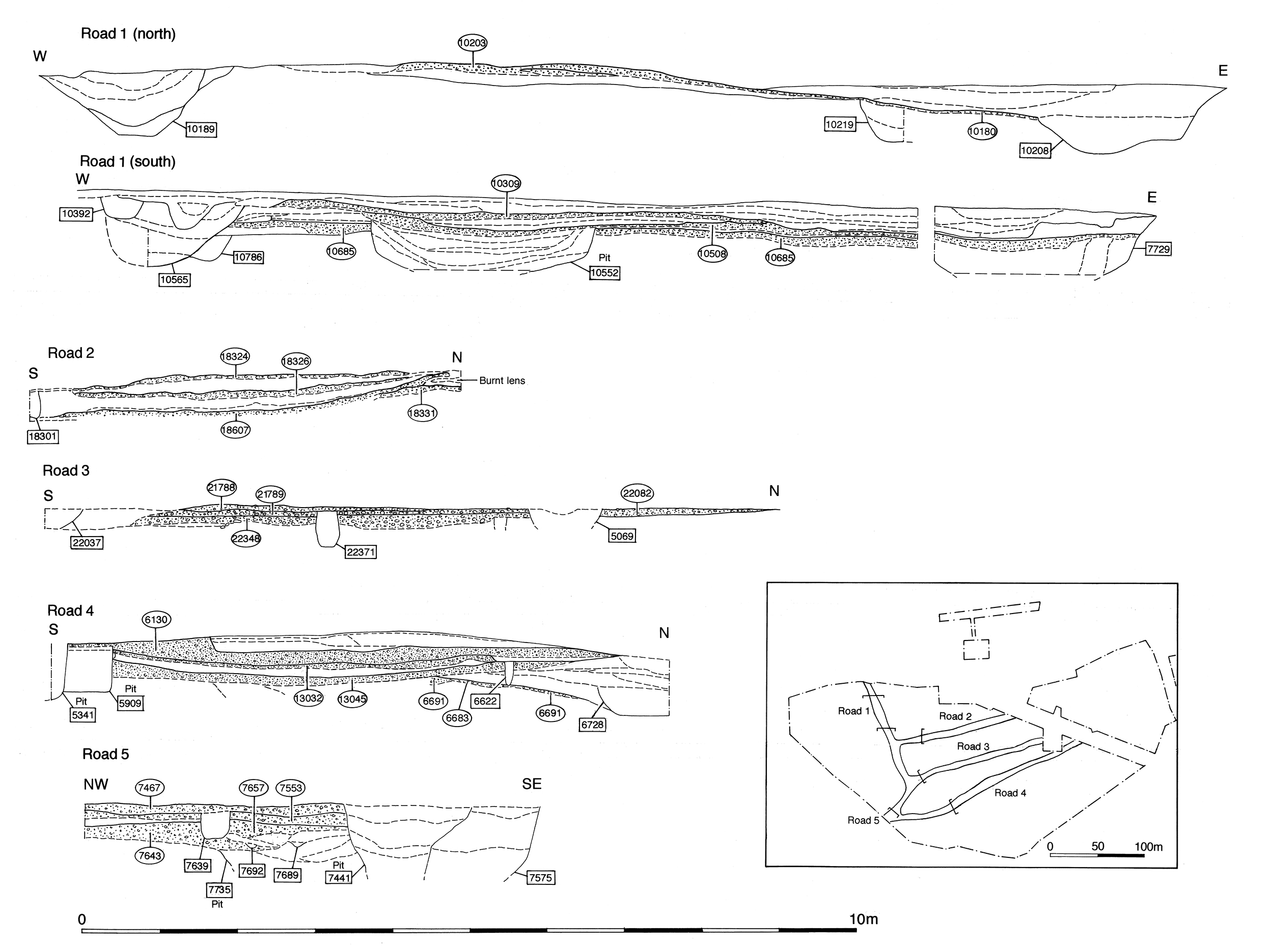
Unlike in Period 3, there is little concerted resurfacing of the northern part of Road 1 in Period 4 (i.e. in the Haul Road or northern trenches of Excavation Area F). Surviving deposits seem to represent more ad hoc episodes of road maintenance and repair (Figure 58). However, it is clear that earlier surfaces survive and remain in use as a thoroughfare. The surfaces are cut by features and overlain by deposits that seem to constitute use, wear, repair and possibly neglect. The following describes these from north to south.
Through the later 2nd to 3rd century, deposits of silt 10279, 10294, 10301, 10306, 10373, 10497, 10499 and 10505 (Group 814) build up on the Road 1 surface that had been laid down in Period 3 just north of the Road 1/5 junction (in the Area F south trench). These deposits contain varied assemblages of pottery, tile, iron nails, animal bone and daub and are interpreted as accumulation through use or perhaps deliberate levelling/bedding for overlying surface 10281 (Group 815). This new surface is a thin, compacted, sand and gravel layer with irregular edges to the east and west, overlain by patchy repairs. It forms the latest surviving Road 1 surface and, as it partially overlies the earlier eastern roadside ditches, perhaps represents a slight eastward shift or widening of the road. The western roadside ditch 10529/10392 (Group 361 Period 3) may continue in use.
Compacted gravel deposits 6296, 7549 (Group 862), 7509 and 7496 (Group 866) represent surviving parts of a single continuous surface bedded on silty sand 7756 (Group 861) laid down the eastern side of the road next to OA33. This, possibly localised, episode of road surfacing appears to involve the widening (or reclamation of the eastern edge?) of Road 1. The surface seals the western wall remains of Building 54, indicating a date no earlier than the late 2nd century (and more probably early/mid-3rd century) for its construction. Virtually no dating evidence is collected from the road deposits themselves.
Up to 0.16m-thick layers of pebbles and silt 6775, 6886, 6920 (Group 538) constitute an undated roadside accumulation at the south-east corner of the Road 1/5 junction (i.e. in Excavation Area H). These deposits are sealed by Road 1 resurfacing (Group 540), comprising a sequence of three compact gravel surfaces with intervening silt accumulations. The first road surface in this sequence, 6885/6889, is up to 0.15m thick. Those above are less substantial but still tangible. Gravelly silts 6827, 6807 and 6689 overlie the first Period 4 surface and are overlain by compact pebble surface 6705. Further pebbly sandy silt 6537 and probable wear hollow 6298 overlie the road, the latter being capped by pebbly surface repair deposit 6649. These are overlain by third substantive road surface 6265/6294/6556, which is up to 5cm thick. Grey silty pebble layer 6259 on top may be further surfacing or simply degradation of the road layer below.
Further south, where Road 1 is investigated at the north edge of Excavation Area I, compacted gravel layer 10267/10281 (Group 815) is partially exposed over earlier road surfacing. In excess of 5m wide and 0.15m thick, it is clearly a surface of Road 1 that stops short of later ditch 25247 (Group 642 Period 5) to its west, with which it appears to remain in use. Unusually, this surface contained tile inclusions (3.6kg) along with iron nails, animal bone and a pottery counter (SF2245) and may be a sign of its relatively late construction.
Toward the south end of Road 1 (in Excavation Areas H/I), surface 13394 (Group 633), and an overlying silt accumulation 13419 (Group 634), probably belong to this period, although this is difficult to demonstrate with any certainty. Continued subsidence of Road 1 into underlying pre-road features (principally water-hole 6734 Group 67 Period 2A), exacerbated by apparent relative neglect during much of the early Roman period, is countered by infilling and resurfacing with substantial gravel deposit 6436 (Group 542) being used to fill and consolidate the road ahead of the construction of a new surface. Thin layer of pebbly mortar 6422 is then laid as a foundation to the road surface, 6410, itself a thin deposit of metalling little more than a single pebble thickness. Wheel ruts 6364 lie on/in surface 6410, with silt 6354 on top and in ruts, overlapped by possible make-up layer 6379. 6379 is cut by beam slot 6366, which is in turn overlain by loose (possibly the last) ?surface layer 6275.
Widespread loose gravel and silt deposit 10150 (Group 903) overlie the northern end of Road 1, probably constituting the weathering or wear of Period 3 surfaces and its dispersal (by washing, sweeping or merely ongoing use?) across the general vicinity. Being at the top of the surviving sequence, the dating for this activity is vague, though probably prolonged. Features 10140 and 10143 (Group 812) are elongated ruts filled with gravelly silt, while 10183 (Group 813) seems to be a wear or subsidence hollow filled with silt, rather than a cut per se.
Gravelly clay-silt 10104 and dirty gravels 10115 and 10127 (Group 813) are the latest deposits in this sequence and the most abundant in artefacts. Of these, 10104 is the most significant, covering the whole width of Road 1 and containing 58kg of tile, including voussoir, and a large amount of pottery. There is also a significant metalwork component, with twenty-nine iron nails and various other iron, copper alloy and lead objects being collected from it. The pottery from these deposits supplies a broad 3rd century date, with significant residual components. 10115 contains a denarius of Caracalla (SF2199) dated to AD 212-217, and an iron split-pin (SF2194), which may be from a cart and therefore perhaps indicative of deposits accumulating during continued use of Road 1. It is possible that the tile fragments are a deliberate inclusion in an attempt to maintain some kind of durable road surface once formal replacement and repair of metalling had been abandoned.
Elsewhere at the northern part of Road 1, a similar rut 10265 (Group 817) forms in the Group 815 surface (above), and is overlain by tile and sand deposit 10259 (Group 818), which may be a repair and an indication that the road continued in use for some time, perhaps even as late as Period 5. Gravelly deposit 10273 (Group 816) on the western side of the road may represent further repair.
Deposits 10330 (Group 819) and 10289 (Group 820), down the west side of the road (in the Area F south trench), contain high proportions of pottery, tile and metalwork, and are likely to be roadside accumulations closely associated with the deposits on the surface of Road 1.
Internet Archaeology is an open access journal based in the Department of Archaeology, University of York. Except where otherwise noted, content from this work may be used under the terms of the Creative Commons Attribution 3.0 (CC BY) Unported licence, which permits unrestricted use, distribution, and reproduction in any medium, provided that attribution to the author(s), the title of the work, the Internet Archaeology journal and the relevant URL/DOI are given.
Terms and Conditions | Legal Statements | Privacy Policy | Cookies Policy | Citing Internet Archaeology
Internet Archaeology content is preserved for the long term with the Archaeology Data Service. Help sustain and support open access publication by donating to our Open Access Archaeology Fund.