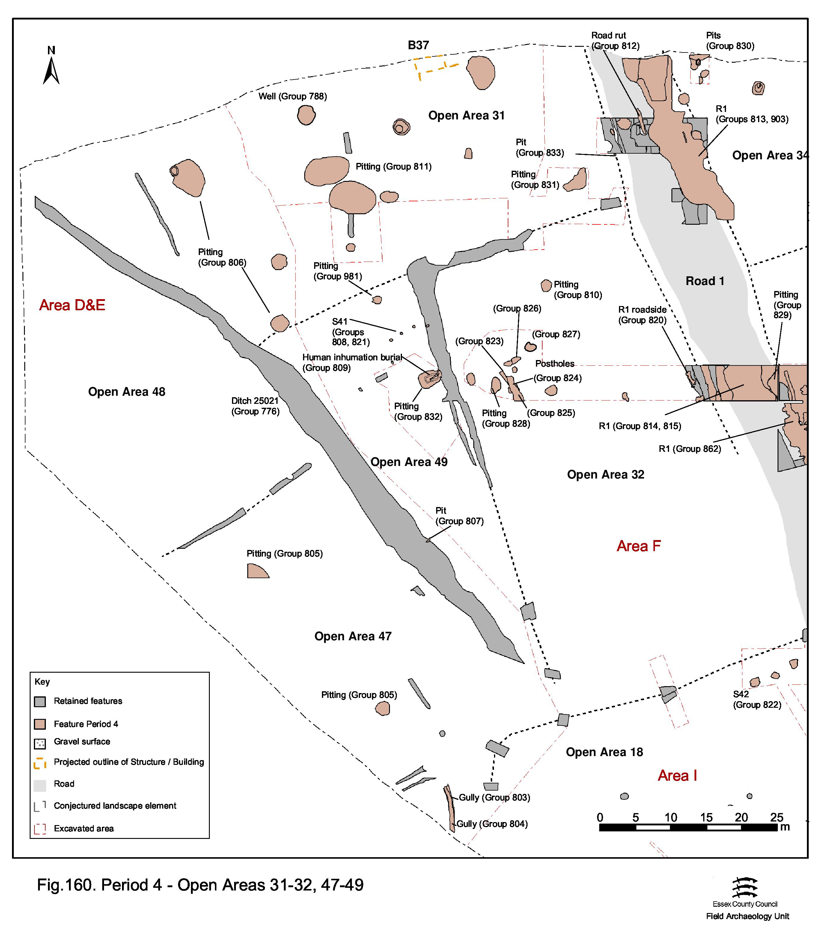
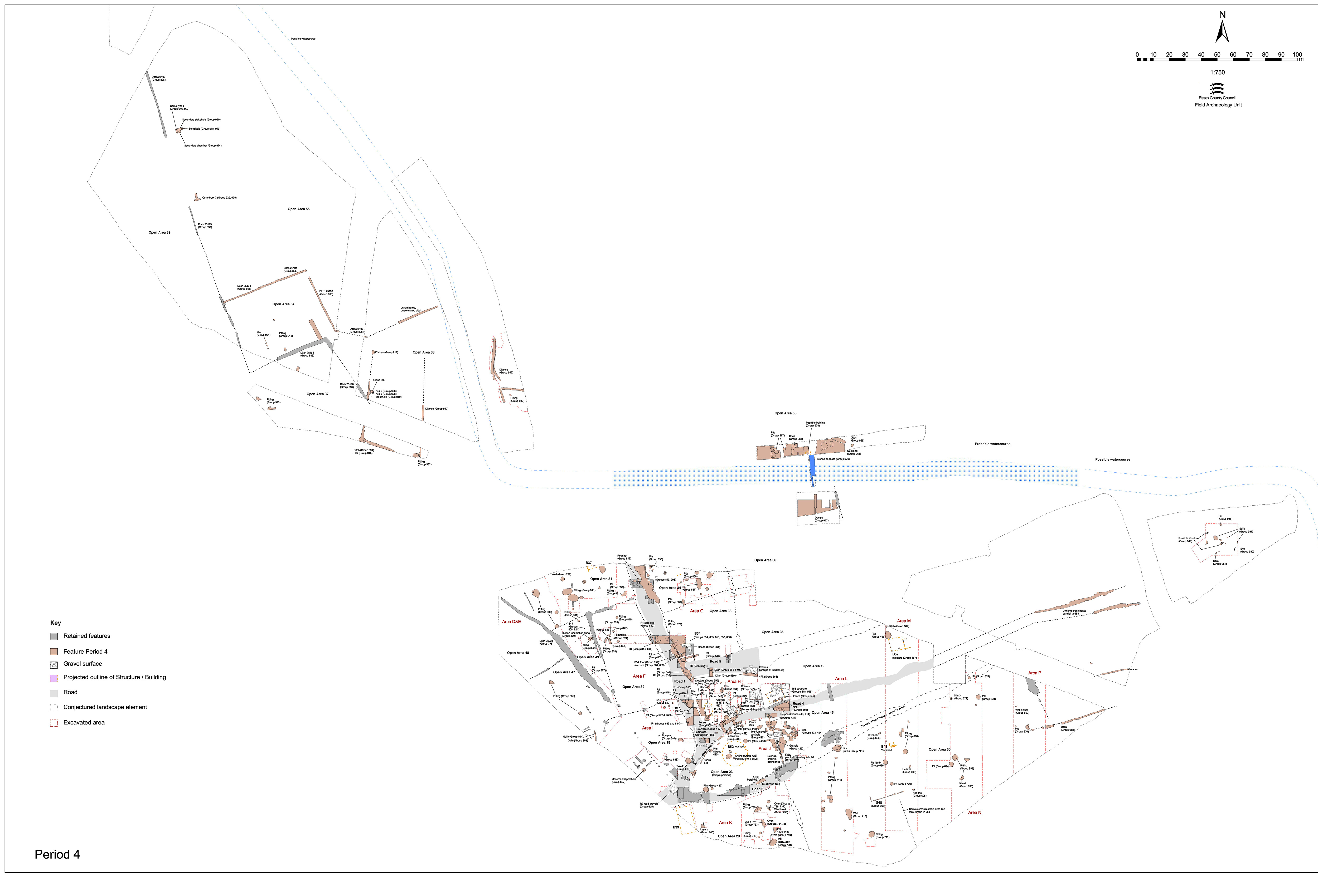
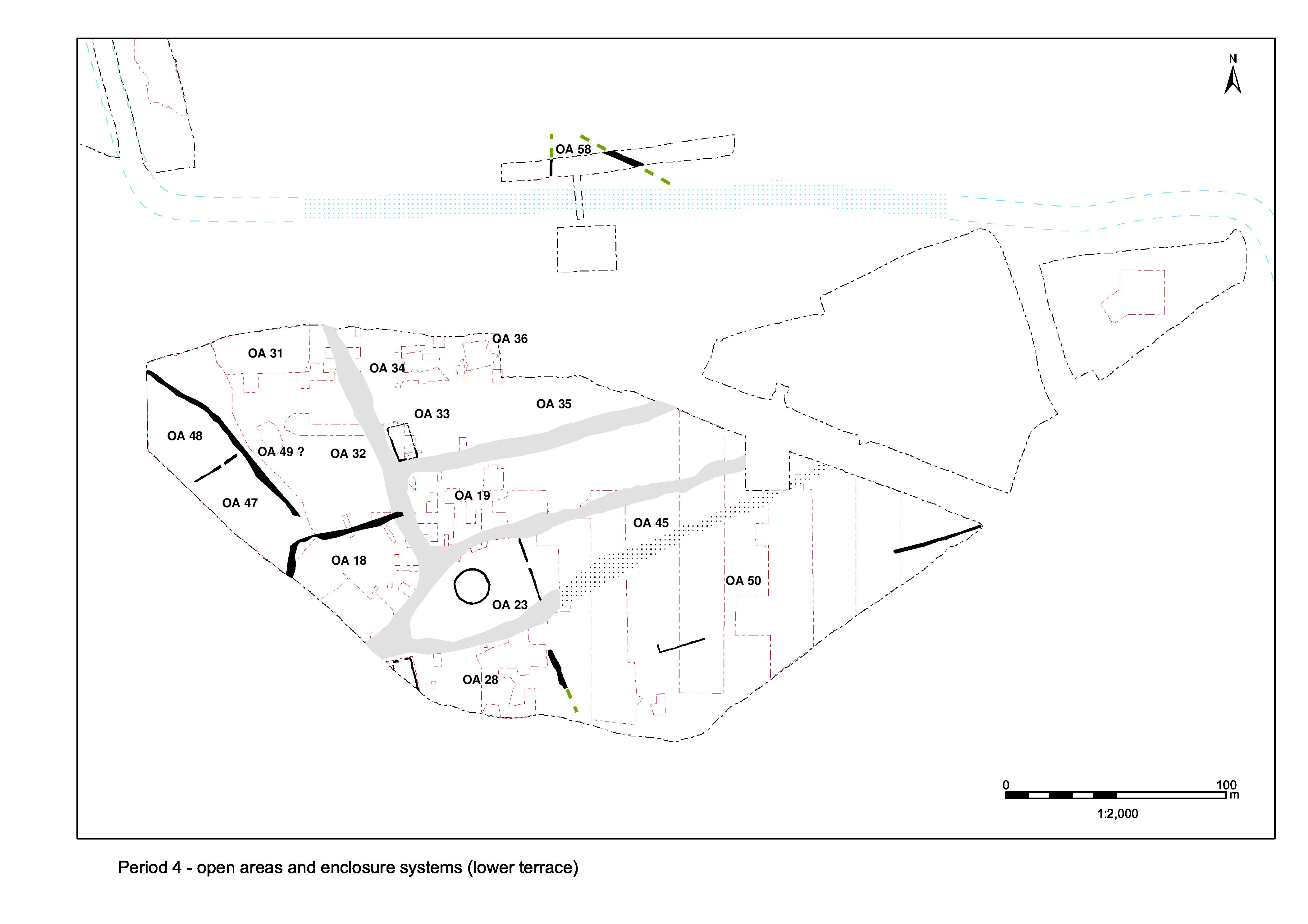
The continuance of major boundary ditch 25021 and the open areas to its west are described in 'Northern Zone, west of Road 1 (west of ditch 25021)'. The enclosures (OAs 31, 32 and 49) and their occupying Period 4 features to the east of the ditch are consequently described here (Figure 160). It is unclear whether or not some or all these landscape entities survive into and through the mid-Roman period. It is entirely possible that the space between ditch 25021 and Road 1 is a single entity during this time. However, for ease of reference as much as anything, Period 4 features are grouped and described in terms of the three open areas that seem to exist late in Period 3.
While there is little evidence of definitive signs of occupation, there are hints of structures present at least alongside Road 1 (i.e. in OA32).
Open Area 31 is assumed to survive throughout the mid-Roman period as a more-or-less distinct entity, unchanged in its extent from Period 3B, though its southern boundary with OAs 32 and 49 may no longer be formally defined (Figure 160).
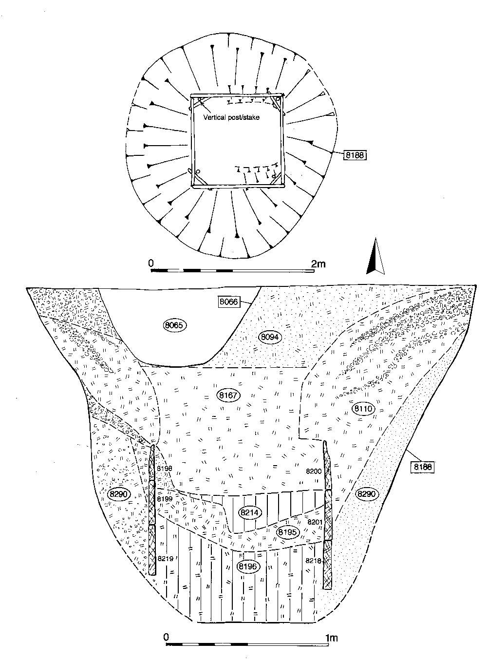
Although well 8188 is constructed in Period 3B, its wood-lined shaft contains a sequence of waterlogged fills (Group 788) the deposition of which predominantly dates to Period 4 (Figure 103). Primary fill 8196 is a peaty clay containing wood fragments and animal bone, though little else in the way of cultural debris. Two notable wooden artefacts are contained in this deposit; 'sword' (SF2758) and 'fence pale tip' (SF7603) (see FF20, nos 165 and 169). Above is a sequence of organic and clayey silt accumulations. The top deposit (8167) includes slumped clay lining, indicating the well's disuse and deterioration/collapse of the timbers. Lastly, a substantial clay-silt deposit (8094), possibly a deliberate infill of rubbish, fills the remaining void of the disused well. This deposit contains significantly more finds (nails, and other iron objects, two coins (one illegible sestertius, one AE3 of House of Constantine probably intrusive from the ditch above, or possibly immediately after the feature was filled), lava quern, glass fragments, a sharpening stone, 7kg of brick and 6kg of tile, 4kg of bone and 600 sherds of pottery). Although dating evidence is sparse for the primary fills, the disuse and backfill deposits supply a late 2nd to early 3rd century date.
Mid-Roman period pits of varying size and shape are scattered across the interior of OA31; few are inter-cut, though a number are evidently re-cuts of Period 3 pits and some are themselves subsequently re-cut.
Pits 9038, 8080, 8114 and 10062 are the largest excavated examples. The remainder are significantly smaller and relatively evenly scattered. There is a clear size division between small (under c. 2m) and large (3.5-6.5m), but no spatial patterning evident. Regardless of size, almost all seem to have functioned as rubbish pits, although some of the smaller examples may betray a different original purpose. Pit 10055 is the largest of the 'small' pits; a circular cut of 2.2m diameter, and significantly deeper than other small pits at 0.65m. It contains two episodes of clay lining, the first being partially removed by cleaning or re-cutting and the latter truncated by a sequence of successive re-cuts 10029 and 10006. This sequence is similar to that of Period 3 pit 10026 (Group 789), which lies only 20m away. This incidence of re-cuts, indicating the prolonged and repeated use of a feature, is evident in other pits too. 10012 is a small oval re-cut within Period 3 pit 10023 (Group 789), and 10020 possibly a deliberate re-cut of pit 10044 (Group 789 Period 3). It is evident that the Period 4 pitting is not a distinct phenomenon, but part of a continuous practice extending on from Period 3. Indeed some of the larger Period 3 pits may simply continue to accumulate material into Period 4; 8269 (Group 790 Period 3) contains a sequence of dated fills spanning the early/mid-2nd to late 2nd-early/mid-3rd centuries AD. Similarly, 10062 clearly begins filling in the 3rd century but receives further material in the later 4th.
The large pits are generally bigger than those of preceding periods in OA31. They may therefore represent a new development in disposal practices, which is suggested in other areas too, though elsewhere this often seems to be more of a later Roman phenomenon when material is seemingly accumulated above ground for longer (i.e. middening) prior to its disposal in fewer, larger pits.
On the eastern side of OA31, solitary pit 10094 (Group 831) is located close to Road 1. This pit contains a substantial artefact assemblage which, apart from the 800+ sherds of pottery, includes twenty-eight nails, ironwork, tile, bone and a glass fragment.
This profusion of finds within the OA31 pits is quite distinct from the mid-Roman pits (Group 830) to the east of Road 1, with the exception of pit 10353. Most striking is the variety of non-ceramic material - glass, iron objects, copper-alloy objects and cast waste, querns and other stone, all appear relatively frequently. Of the ironwork, nails are the most numerous and their presence may indicate a change in carpentry and building construction techniques (e.g. less reliance on jointing and pegging) or else a change in disposal practice.
On the eastern edge of Open Area 31, a post-hole 10156 cuts the infills of roadside ditch 25245 (Group 361 Period 3). This may provide further, piecemeal evidence for the fencelines that seem to be inserted along many of the principal boundaries in their later phases.
If OA49 is accepted as a tangible entity persisting into Period 4, its occupying features tend to be located along its eastern periphery, presumably marked by a perpetuation of former boundary ditch 25039.
The larger pits form a small cluster alongside the eastern boundary (Group 832) and are similar to those in Open Area 31 to the north. Sub-rectangular pit 10782 is unremarkable other than for the fact that it has a later inhumation grave inserted into its top (Grave 10776, below). Adjacent pit 8260 contains a re-cut 8276. To their south, 8280 is the largest of the pits occupying OA49.
Small oval pit 9243 (Group 981) lies on or close to the perceived northern edge of OA49 and is similar to others nearby but ostensibly within OA31. Even smaller pit 9384 (Group 807) lies in seeming isolation in the southern part of the enclosure, alongside boundary ditch 25021.
The OA49 pits generally contain artefact assemblages comprising substantial quantities of pottery and tile with some animal bone and ironwork. Pit 9243, a re-cut of tile-lined Period 3 pit 9358, is notable for its particularly large, 25kg, tile component.
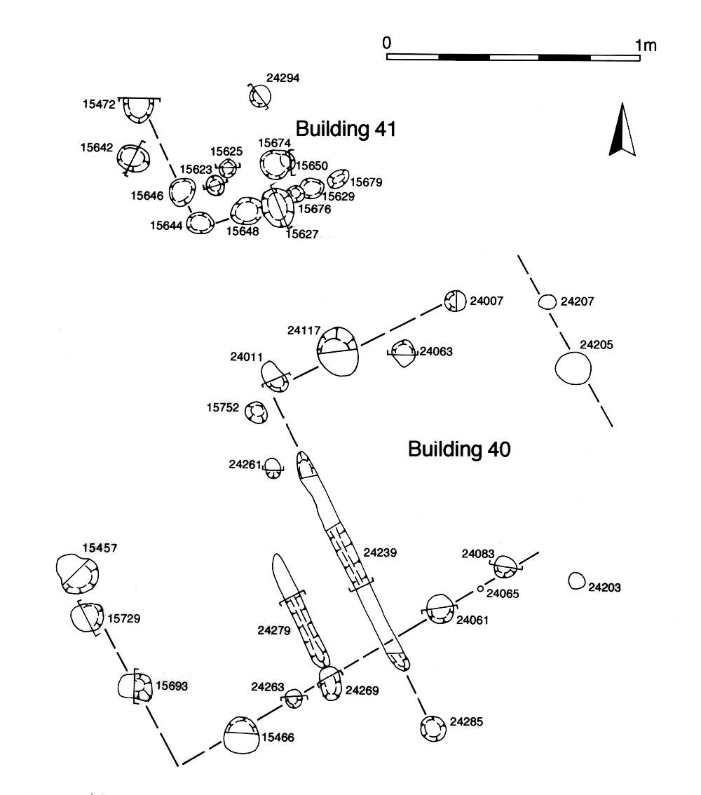
Six similarly proportioned post-holes (8228, 8233, 8238, 8243, 10788 Group 808, 8236 Group 821) could be construed to form a circular arrangement - Structure 41 - some 7m in diameter (Figure 98). They are regularly spaced, particularly if an extra, unexcavated and unnumbered post-hole is included. However, the dating of this structure depends wholly upon the reliability of the relationship of post-hole 10788 with pit 10782 into which it is recorded to be cut, though this relationship is far from certainly established. There are no datable finds in any of the component post-holes.
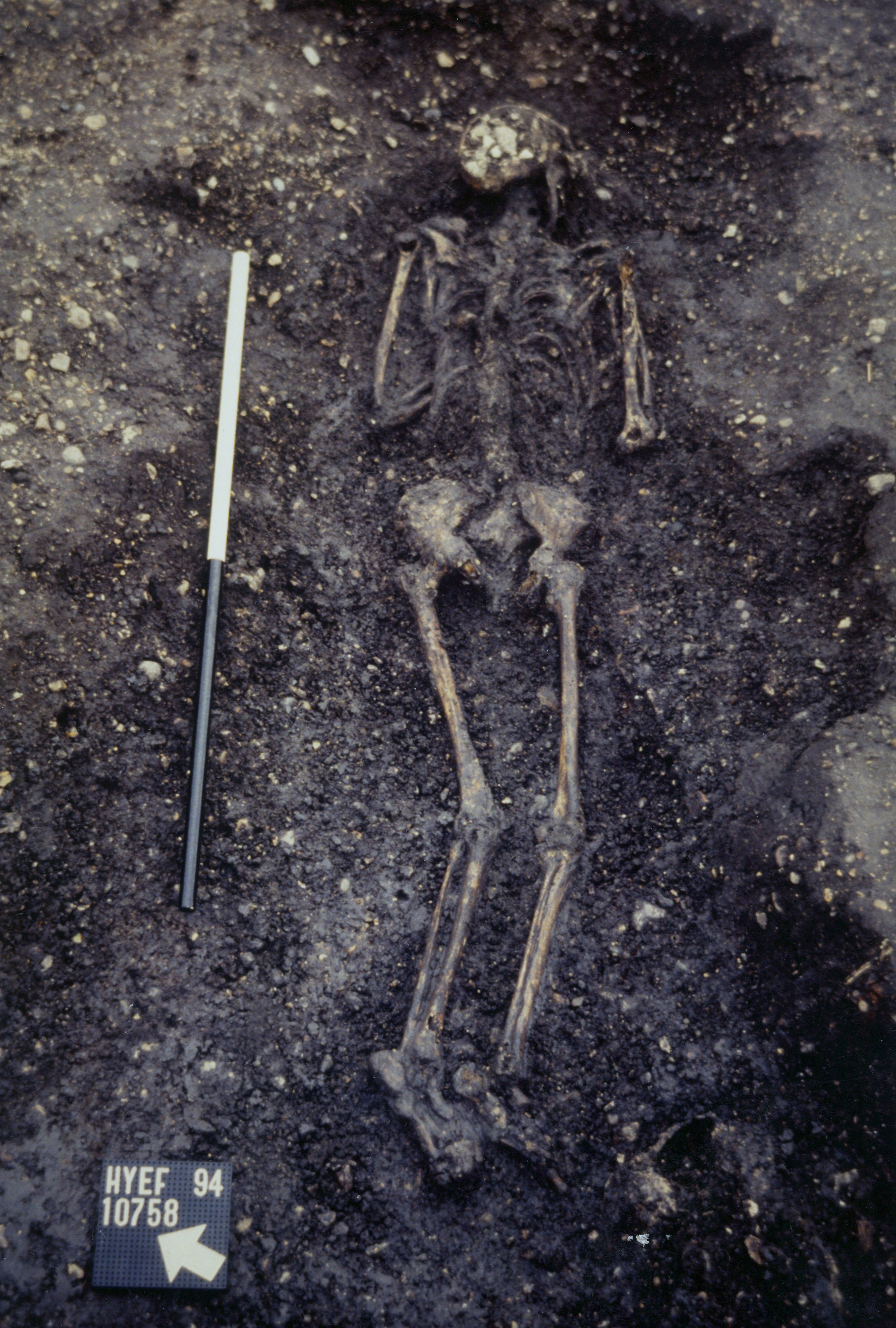
Shallow, rather insubstantial, grave cut 10776 (Group 809) is inserted into the top of infilled pit 10782 (Group 832). The position of the grave, tight up to the former ditch 25039, again suggests that the OA49/32 boundary may still be functioning. The cut is 2.5m long, 1.0m wide and survives to a depth of only 0.28m (Figure 141). It is oriented NE to SW with the skull located at its north-east end. No remains of a coffin are identified, nor are grave goods present.
The interred adult female skeleton is extended prone with the arms drawn in to the chest, perhaps indicating a shrouded burial. The authenticity of the grave cut, as excavated, is uncertain and it remains possible that the burial may be inserted into what is simply a convenient slump hollow in the top of the underlying pit. The informal nature of this isolated burial is supported by the fairly arbitrary attitude of the body.
The pottery and large amount of tile, animal bone and slag suggest the infilling of the grave with a rubbish deposit. This material most likely derives from the disturbance of the fills of the mid-3rd century pit into which it is cut, rather than being directly associated with the burial and can therefore provide only a terminus post quem for the event (and a 4th or even early 5th century AD date for the insertion of the grave is therefore possible).
A series of structural slots or gullies in the north-west of OA32 seem to indicate the presence of a building. Cut 10537 (Group 823) is a 0.4m-wide, clay-lined gully. Eight iron nails (SF5215) survive in situ within the clay, along with one round (10554) and one square (10564) stake-hole (Group 824). Truncated at either end, it runs on a NNW-SSE alignment for 2.3m and may make a right-angled turn at its northern end. Gully 10341/10369 (Group 825) appears to be a broader replacement of this feature. These linear features are orthogonal to Road 1, c. 27m to its west, and might constitute the partially excavated remains of a building. Post-pipe 10637 (Group 827) is located only 1m from the gully terminal and may be associated (though there is some stratigraphic uncertainty over this feature, which may cut midden dumps (Group 841) laid down in Period 5). 10641 (Group 826) appears to be an inadvertent renumbering of the gully.
A 1.15m square cut, some 0.55m deep, is located immediately south of structural gully 10537. A thin deposit of clay lines its base. At the centre of the feature is a 0.8m square 'shaft', 10365, which bottoms onto the clay lining. The pit is backfilled with a clayey sandy silt, itself capped with a layer of clay around the 'shaft'. It is possible that this is on or near the contemporary land surface. Superficially, this looks like a post-hole with an in situ post-pipe. However, a 0.8m-square post is perhaps unlikely and the ridge in the clay lining of the base is more suggestive of the former presence of a wooden lining. The 'shaft' fill contains a large and varied artefactual assemblage, including pottery, tile, glass and a lead sheet fragment (SF3995), which seems more characteristic of a rubbish backfill than gradual replacement of an in situ post. A storage function may perhaps be surmised. A very similar Period 3 pit (8540 Group 657) is present in Southern Zone OA25.
A single small and round rubbish pit 10038 is located toward the north-west corner of OA32, albeit more pits could well have been present within the uninvestigated parts of the enclosure interior. For such a small pit, it contains a significant quantity and diversity of artefacts including an iron staple and carpenters dog (no SF numbers), vessel glass and substantial amounts of pottery and tile.
Technically, gully 25033 and its re-cut lie outside of the Northern Zone's southern limit, as marked by the continuance of ditch 25015. In reality it lies neither in OA47 or OA18, but in the corner of a separate (and un-numbered) Central Zone enclosure immediately west of OA18. However, the presence of gully 25033 and its re-cut is interpreted as indicating the continued importance of this point of access between the Northern and Central Zones.
Gently curving gully 25032 (segs 9566, 9576, 9767, Group 803) is approximately 1.0-1.1m wide and around 0.45m deep, with a single fill. The northern end is not located, as it is 'lost' within inter-cutting Period 2 pits 9801 and 9846, though it is presumed to have ended above them. A rounded terminal is located at its south end, establishing that this gully is at least 5.5m long.
Re-cut 25033 (segs 9564, 9591, 9598, Group 804) is shallower than the original gully but follows its line exactly, though extends further south beyond the edge of excavation. A c. 7m length is recorded. No other structural indications, such as post-holes, are present within either of these gullies, which appear to denote the foundation of a fenceline that functions either to block the entrance between the settlement zones or else to channel and regulate the movement of livestock through it.
Internet Archaeology is an open access journal based in the Department of Archaeology, University of York. Except where otherwise noted, content from this work may be used under the terms of the Creative Commons Attribution 3.0 (CC BY) Unported licence, which permits unrestricted use, distribution, and reproduction in any medium, provided that attribution to the author(s), the title of the work, the Internet Archaeology journal and the relevant URL/DOI are given.
Terms and Conditions | Legal Statements | Privacy Policy | Cookies Policy | Citing Internet Archaeology
Internet Archaeology content is preserved for the long term with the Archaeology Data Service. Help sustain and support open access publication by donating to our Open Access Archaeology Fund.