
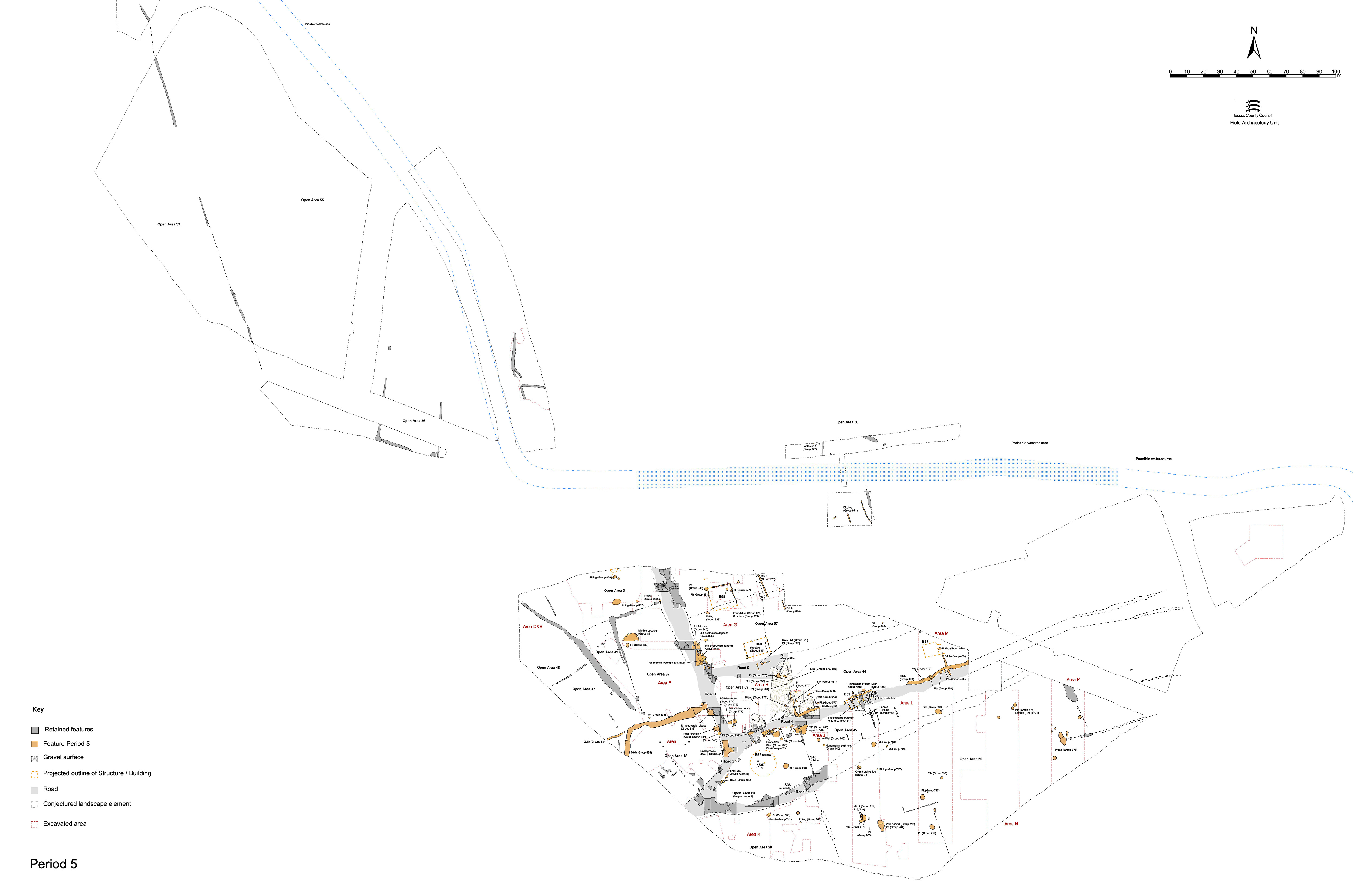
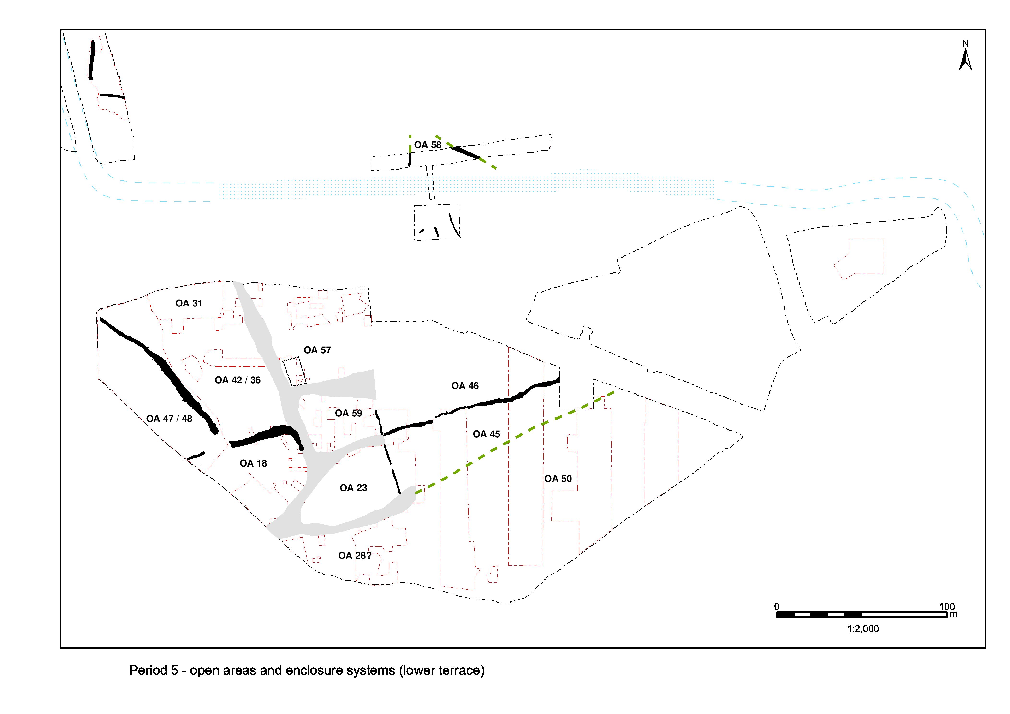
OA19 is split into two with the Period 5 introduction of a division, Structure 44, on the same alignment as that of the temple precinct frontage wall, Structure 46. While it has been previously speculated that such a subdivision of OA19 occurs earlier, this is the first time that it is formally marked. As such, the western end of OA19 is now termed OA59 and the eastern remainder as OA46. The creation of this division and the occupation of the resultant OA59 are described below. Activity within OA46 is described in 'Central zone, Open Area 46 (formerly OA19 east)'
OA59 contains little apparent occupation activity (Figure 180), with Building 55 passing out of use and even Late Roman pitting being sparse. Silts accumulate across its interior and it is difficult to explain why there is a need to impose a formal boundary to its eastern limit.
The position of a likely wall or major fenceline (Structure 44 Group 567) is marked by a sinuous slot 16196/16197 that runs roughly NNW-SSE across what is hitherto OA19. Its line is punctuated by a series of large, regularly spaced, post-holes (16177, 16179, 16261, 16265). The southern terminal lies immediately north of Road 4 at a point coinciding with the western end of the roadside ditch 25260 (Group 584). It is traced northwards for a distance of 15.5m, before becoming obscured beneath unexcavated deposits. It is presumed that the slot extends at least as far north as the edge of Road 5.
The slot itself appears too irregular to be a foundation and is more plausibly interpreted as a robber-trench. The bulbous southern end of slot 16197 is suggestive of robbing of the timber upright from post-hole 16265. The slot and its component post-holes contain large quantities of tile and significant amounts of rubble stone, principally septaria and quern fragments but also tessera. Much of this could be the remains of a robbed-out wall footing or dwarf wall that runs between the posts. The robbing occurs in the later 4th century AD. The extent to which this Late Roman feature perpetuated an earlier boundary is uncertain, but suspected.
In the south-west corner of the open area, close to the junctions of Roads 1 and 4, the layers and spreads of material that overlie the remains of Building 55 (6208, 6228 ,6233, 6237, 6238 Group 574, 6195 Group 576), contain indications of burning and quantities of tile. They may derive from the destruction of the building, although they admittedly also contain a range of domestic rubbish. The destruction of Building 55 occurs during the 3rd century, probably during Period 5.
Possible slots (6058, 6252 Group 568) lie across the OA59 interior. The largest of these, 6058, does not lie on any alignment orthogonal to known structural activity. The other, located close to pit 6641 is smaller and equally inconsistent in its alignment. While these cuts may represent further structural activity, the extant remains are too sparse to permit meaningful interpretation. Other similar slots lie on the opposite side of S44.
At the southern edge of the open area, close to Road 4, dark sandy silt 16311 (Group 570) is one of a sequence of similar layers that subsequently extends over the top of surfaces and roads. They may be occupation deposits but could equally possibly be related to abandonment. Layer 16311 contains 3rd century pottery.
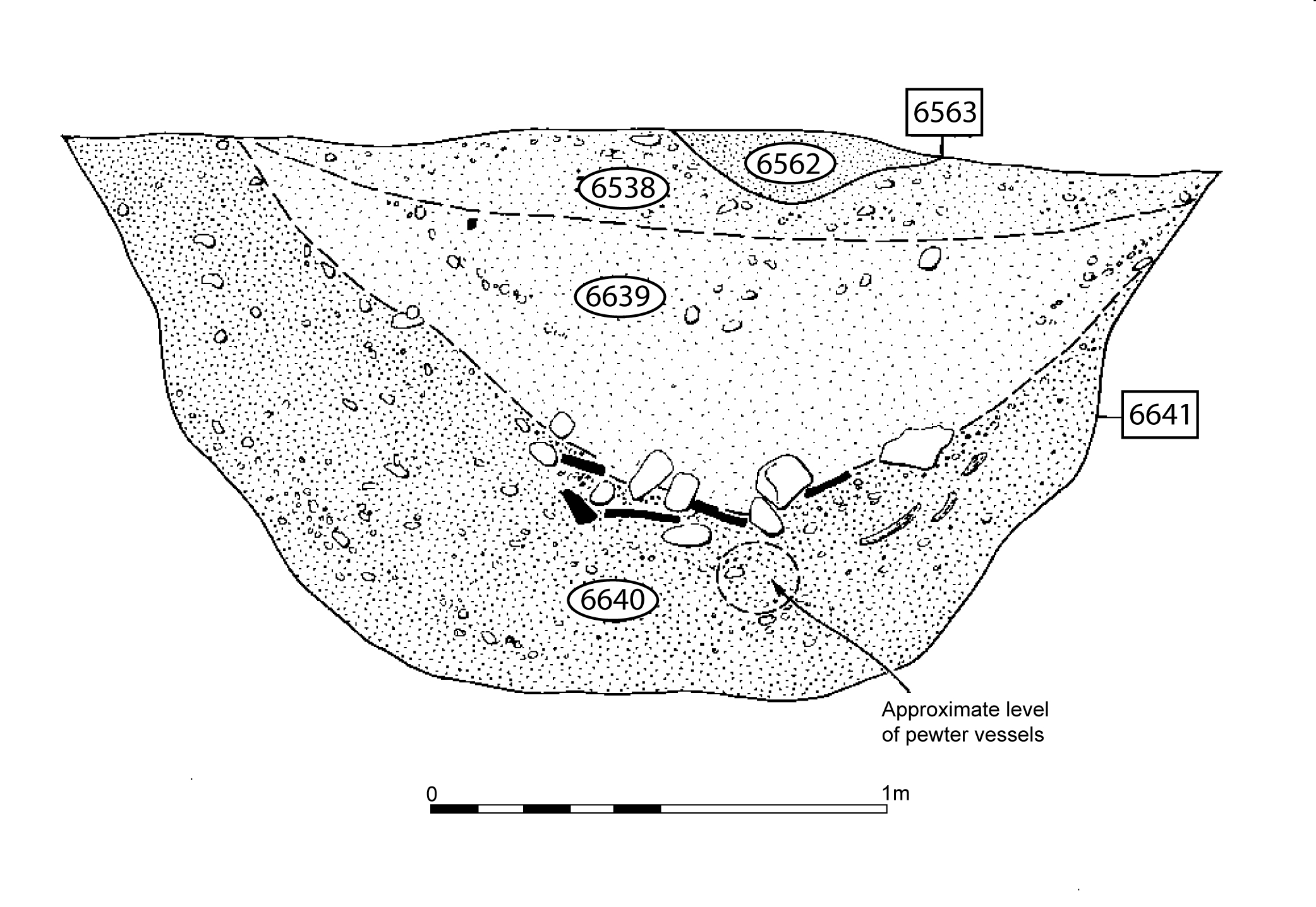
Originally interpreted as a likely well, pit 6641 is an irregular oval cut some 2.8m by 2.5m and 1.2m in depth, situated towards the north of the open area. The cut is steep sided and intrudes through the natural brickearth into the underlying gravel. No traces of a timber or clay lining are discerned, although five possible post or stake impressions are noted in the north-western edge. It contains a distinctive fill sequence (Figure 185).
Bottom fill 6640 contains large amounts of bone, but most importantly five pewter bowls and dishes. Owing to the difficult, waterlogged, working conditions, it was not possible to investigate their deposition in detail, although it is clear that they represent a deliberately deposited hoard. Given their location at the bottom of this shaft-like feature, it is likely that pit 6641 is constructed specifically for the purpose of their interment.
The only other metalwork from the pit is a small scrap of lead, but the same context contains the articulated remains of a decapitated horse. Although recorded as part of fill 6640, the 14kg of tile retrieved from the pit is in fact a sealing deposit overlying the initial covering of the hoard. The pit is subsequently backfilled with silts. Although all fills contain 4th century AD pottery, a considerable 1st-3rd century residual element is present, presumably derived from infilling with rubbishy soils.
The hoard itself comprises a group of five nested vessels, two plates and three hemispherical pedestalled bowls or dishes. A Chi-Rho symbol is scratched onto the underside of one of the bowls (SF3420).
It may be possible to speculate about the association of pit 6590 with 'votive' pit 6641. Pit 6590 contains lenses of brickearth in its fills that may hint at packing, perhaps within a large post-hole marking the votive pit.
Modest-sized rounded pits of Period 5 date are seemingly scattered across the western end of OA59 as represented by pits 6127, 6149, 6191 and 6317 (Group 577). Of these, pit 6149 is particularly noteworthy for its central positioning within the enclosure, and contains a fragment of shale platter (SF7723).
Small pit 6527 (Group 580) looks to lie on the postulated northward course of the Structure 44 boundary. It may even be part of it - perhaps the terminal of slot 16196/16197.
Pit 6223 (Group 575) is located toward the south-west corner of OA59, close to pit 6127, and apparently encroaches upon the interior of Building 55, so demonstrating the abandonment and disuse of the structure by or during the Late Roman period.
Internet Archaeology is an open access journal based in the Department of Archaeology, University of York. Except where otherwise noted, content from this work may be used under the terms of the Creative Commons Attribution 3.0 (CC BY) Unported licence, which permits unrestricted use, distribution, and reproduction in any medium, provided that attribution to the author(s), the title of the work, the Internet Archaeology journal and the relevant URL/DOI are given.
Terms and Conditions | Legal Statements | Privacy Policy | Cookies Policy | Citing Internet Archaeology
Internet Archaeology content is preserved for the long term with the Archaeology Data Service. Help sustain and support open access publication by donating to our Open Access Archaeology Fund.