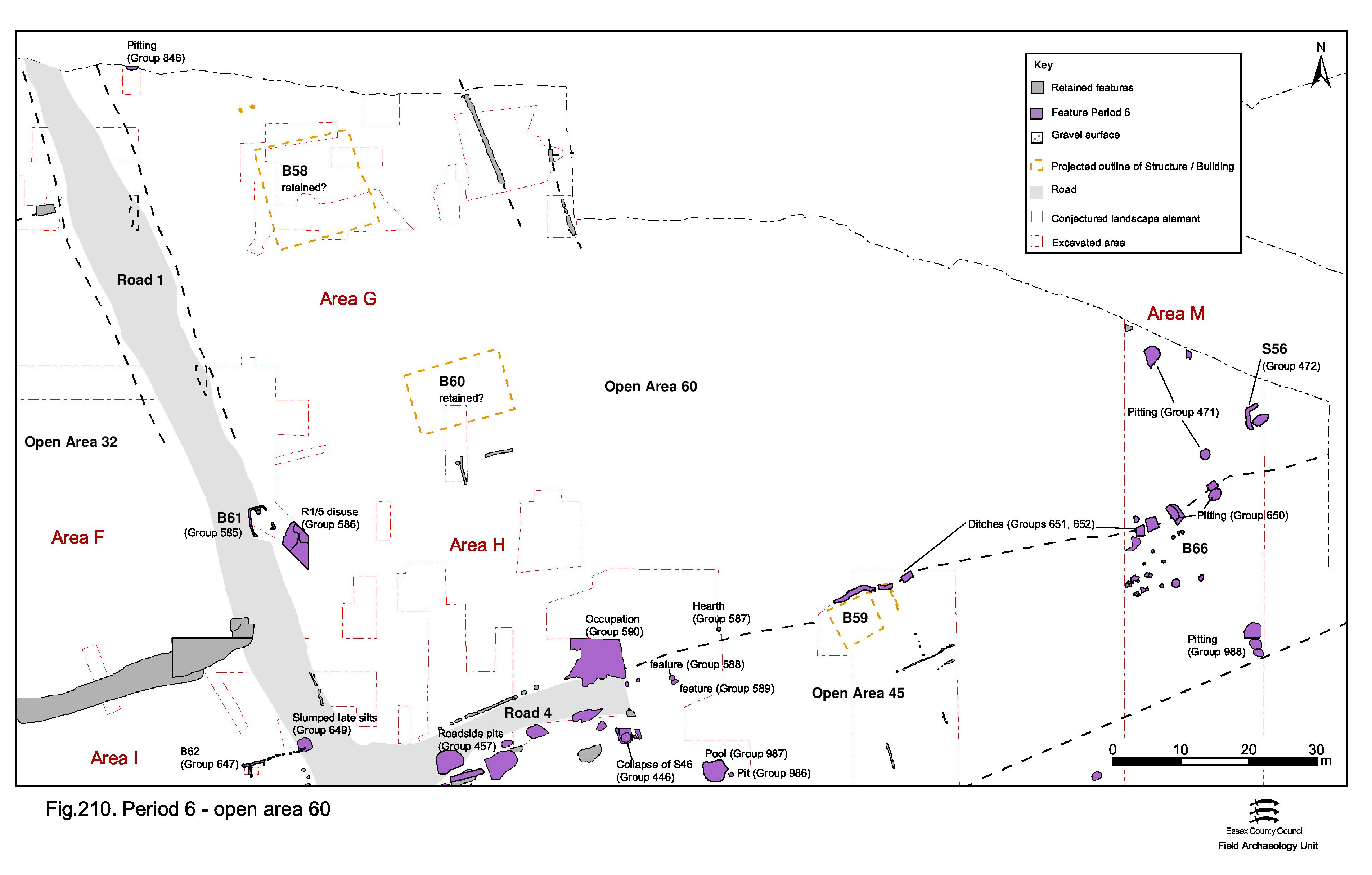
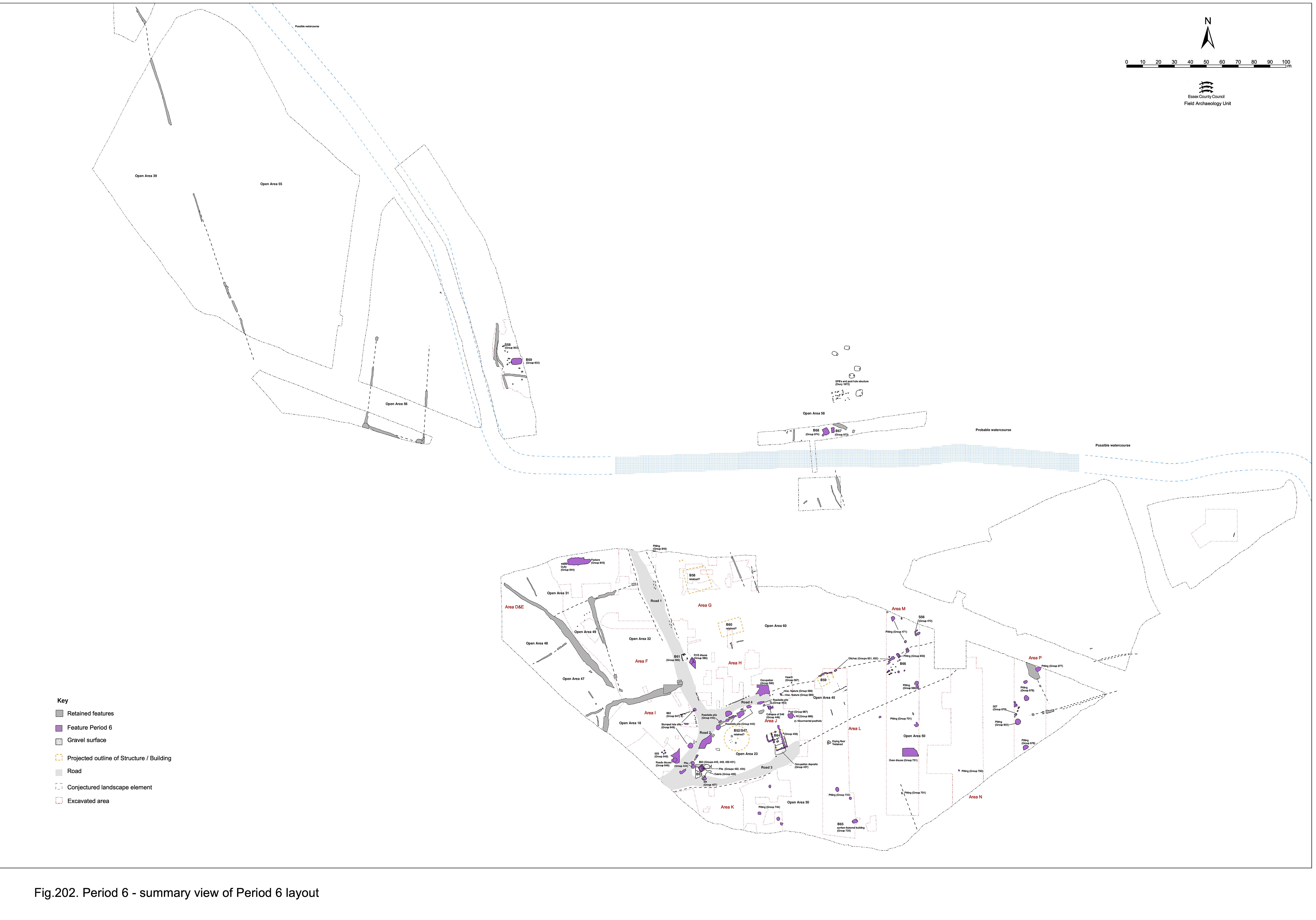
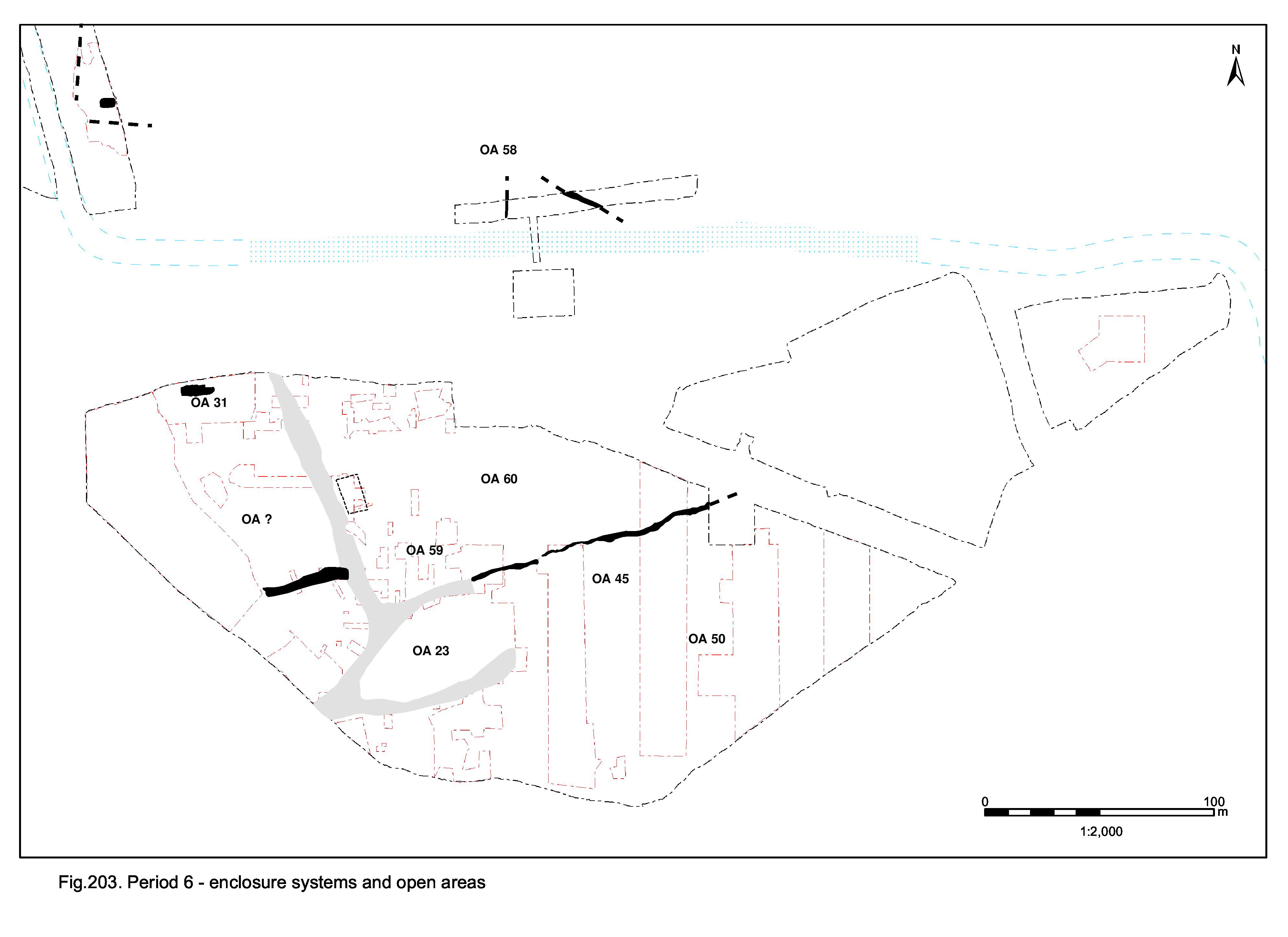
As previously mentioned, the ditch between OAs 45 and 46 continues to accumulate material in the late 4th and 5th centuries and may be assumed to persist as a boundary in the landscape. This would seem to mark the southern extent of a land entity that, in the absence of Road 5, probably extends as far north as the remnants of the watercourse. The presumed continuance of Road 1 constitutes its western extent. This entity is termed Open Area 60 (formerly OAs 46 and 59) (Figure 210).
While its westernmost end (25260) may already have become filled up in Period 5, substantial quantities of ceramic building material, principally tile, are present in the latest fills of ditch 25078/25077/25262 (Groups 651, 652), dividing Open Areas 45 and 46. Occasional tesserae and greensand and septaria rubble is also present.
The stratigraphic position of this ditch in relation to the Period 5 Building 59 is uncomfortable. The ditch so clearly reflects the alignment of Road 4 for much of its course that it is difficult to see how its origins do not lie as a roadside feature. On the other hand, it also seems likely that this ditch and Building 59 are contemporary, at least for a time. It clearly survives as a boundary feature into the late 4th century and possibly into the 5th century, when the eastern ditch elements are finally filled. This latest deposition demonstrates that the ditch is at least partially open in Period 6 - but is it still a functioning and recognised boundary?
As noted, latest Roman pits seem to lie on either side of the ditch, in a band across the eastern parts of both Open Area 45 (Group 988) and Open Area 46 (Group 471). Those at least technically within OA60, though more properly on the boundary, are pits 15078, 15100, 15232, 15664, 25159 (Group 471).
Two further late 4th-century pits 15042, 15225 (Group 650), in all other respects part of the same phenomenon, apparently pre-date the easternmost portion of the ditch (Group 473). There could be a late, undetected re-cut of the ditch present here, or perhaps these pits are cut through the partially infilled ditch that continues to fill after they pass out of use.
In general the pits are moderately sized (between 1.0 to 2.5m in width) and round or oval in plan. They contain apparently domestic finds assemblages that are very similar to those of the Period 5 pits - large quantities of pottery, tile and metalwork, together with occasional stone fragments, which accumulate throughout the late 4th century and perhaps into the 5th. None of these pits (unlike some on the opposite side of the ditch) contain Saxon pottery, though the absence of the occasional diagnostic sherd does not preclude the fact they could be of post-Roman date.
Pit 10125 (Group 846) is the latest in the sequence of inter-cutting pits in the north-west investigated extent of OA60 in Excavation Area G, immediately to the east of Road 1. While indicating a continuity of pit digging at this location, this latest component is also among the largest - some 1.8m in diameter, though only 0.28m deep. It is possible that this pit is in fact earlier 4th century, with later material accumulating within its slump hollow.
On the southern side of Open Area 60, immediately north of the sinuous boundary ditch forming the southern side of the open area, 16273 (Group 587) comprises a c. 0.5m diameter, roughly circular cut, lined with tile and containing a burnt fill. Although the fill contained some slag and some possible iron lumps, this structure is not very convincing as a hearth and is equally unlikely to be a small furnace. Its interpretation remains uncertain.
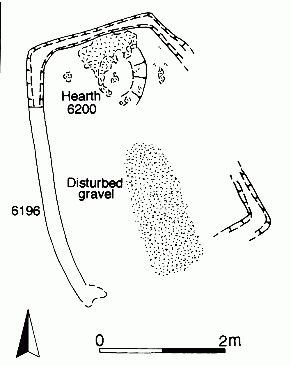
Building 61 (6196, 6200, 25222 Group 585) is situated on the junction of Roads 1 and 5. It comprises a single very shallow slot 6196 that is cut into the upper road surfaces (Figure 211). This slot defines three sides of the structure and returns for the fourth, describing a bow-sided rectangle of 4.8m by 3.5m. Truncation has clearly removed the southern and much of the western wall which, in places, was noted to be little more than a stain or impression in the road surface. The eastern side does not appear to suffer the same degree of truncation and the gap in its slot may be real, defining a doorway. At the north end of the building interior, clay deposit 6200 is either a floor fragment or, more likely, the base of a hearth. Primary records allude to an unnumbered patch of 'dirty gravel' in the southern part of Building 61, which may result from use wear.
This apparently isolated building is deliberately located on the road junction. It is likely that its gravel surfaces, perhaps the only part of the road clearly visible amid an encroaching build up of silt, are selected as a solid foundation and floor for the structure. The imposition of the building surely indicates that, finally, the main thoroughfare of Roads 1 and 2 ceased to function, though remaining a discernible landscape element. In the absence of diagnostic material from its fills, the morphology of the building and its disruptive positioning are indications of a likely Early Saxon date.
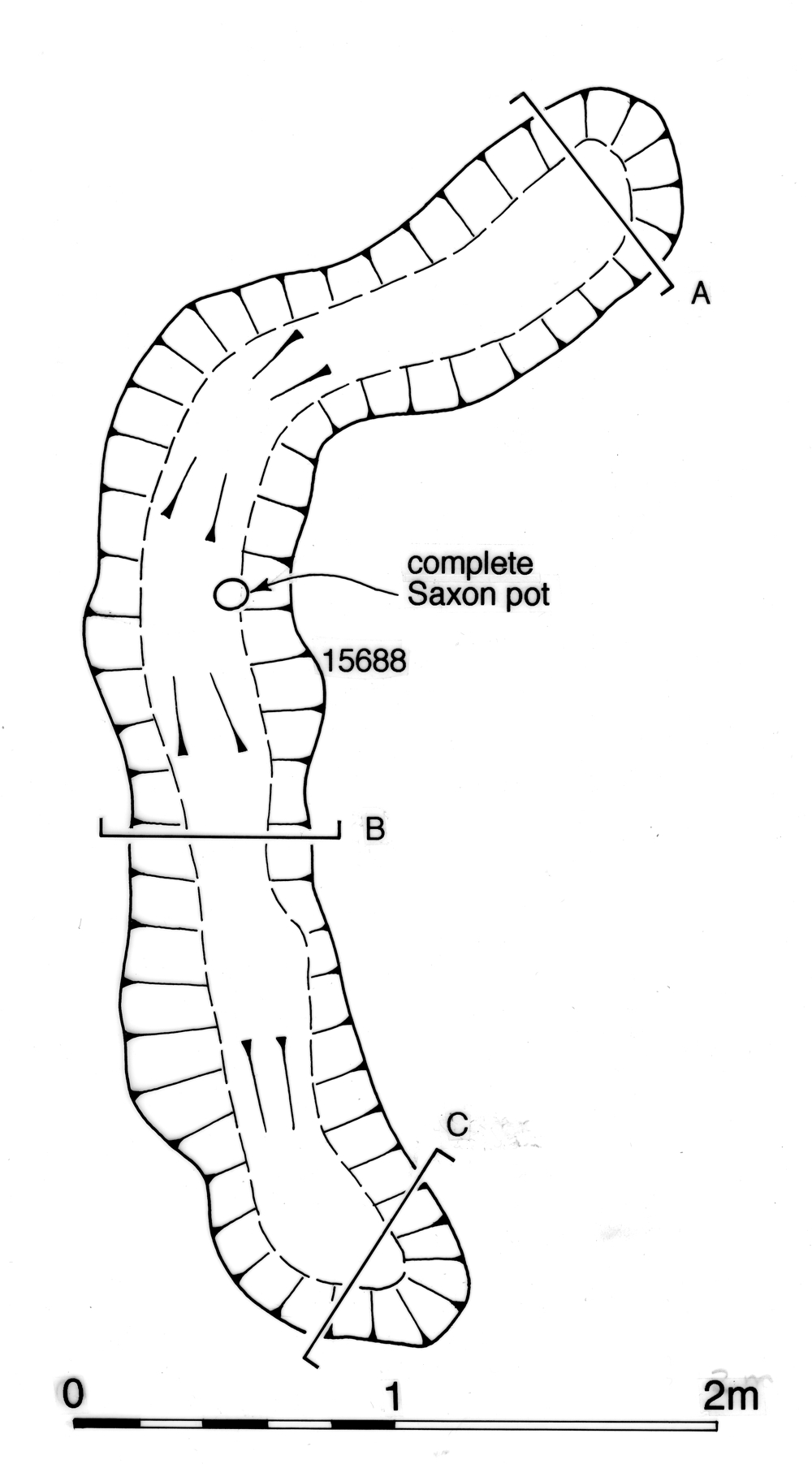
Located at the eastern end of the investigated extent of OA60 (in Excavation Area M), shallow, irregular slot 15688 forms a rough right-angle (Figure 213). Interpreted as a possible fragment of a building foundation, it contains what must be a deliberate foundation deposit of a complete Early Saxon vessel. No other features in the vicinity can be reliably associated with this slot, the only candidates being undated post-holes 15187 and 15090 (Group 1223) to its south. How this structure may relate to either the sinuous boundary ditch 25078/25077/25262 or ditch 25079 is uncertain, although the latter could perhaps provide a fence bounding a land plot around it.
Within Open Area 60 and extending onto by now defunct Road 4, gravelly soil 6008 (Group 590), removed as an arbitrary spit in Excavation Area L, marks the latest of the essentially homogeneous deposits that begin accumulating during Period 5 (see Groups 573, 583). The gravel component of 6008 may be derived from the deterioration of underlying gravel surfaces.
There is one sherd (15g) of Saxon pottery present among the total of 555 sherds (30kg) recovered from this deposit. The remainder of the pottery is mid- or Late Roman. As the integrity of the context is open to doubt, the Saxon sherd could be treated as an intrusion or contamination.
Internet Archaeology is an open access journal based in the Department of Archaeology, University of York. Except where otherwise noted, content from this work may be used under the terms of the Creative Commons Attribution 3.0 (CC BY) Unported licence, which permits unrestricted use, distribution, and reproduction in any medium, provided that attribution to the author(s), the title of the work, the Internet Archaeology journal and the relevant URL/DOI are given.
Terms and Conditions | Legal Statements | Privacy Policy | Cookies Policy | Citing Internet Archaeology
Internet Archaeology content is preserved for the long term with the Archaeology Data Service. Help sustain and support open access publication by donating to our Open Access Archaeology Fund.