This article describes the methodology of a project to collate and analyse the evidence for all the archaeologically known major settlements on the Italian peninsula south of the Po River occupied during the period 350 BCE to 300 CE. The overarching research aim of this project is to employ quantitative and geospatial analyses to understand how and why the settlement pattern of (proto-)urban centres changed during the period spanning the Roman conquest and control of the peninsula. At the core of this research has been the creation of an analytical database and GIS. This article documents the processes of data collation and database architecture, and provides indicative results to illustrate the value of the resulting resource both for the research project's wider aims and for other potential users of the project archive.
An important innovation is the collation and analysis of data on a peninsula-wide scale. This is intended to permit the potential identification of patterns that are not apparent when approached on a site-by-site, or even region-by-region, basis. Regional developments may be compared and contrasted, and thus better contextualised. Although there is already general awareness that supra-regional processes affected ancient settlement patterns, owing to the regionalism of archaeological studies (e.g. Colivicchi and Zaccagnino 2008; Oakley 1995; Paoletti 2008), this awareness remains impressionistic. The database is therefore intended to highlight the chronological and geographical parameters of the supra-regional settlement processes that characterised the period which encompasses the Roman conquest of Italy through to the eve of Late Antiquity.
The database contains both archaeological and ancient textual information relevant to physical and institutional development of these sites over time. A particular purpose of the analyses is to establish with greater precision whether there are chronological and geographical correlations between known historical events, changes in settlement patterns, and the physical and institutional development of these sites. Moreover, the analyses have the potential to identify and elucidate historical processes that are not documented in ancient textual sources. The most significant of these processes is the sharp rise in the number of archaeologically documented major settlements during the early Hellenistic period (Sewell forthcoming). These settlements are contemporaneous with the most intensive phase of fortification construction on the peninsula during the whole of classical antiquity; they also concentrate in the same areas (see also sections 4.8 and 5). These developments are not clearly documented in Roman textual sources and although they occurred during the period of Roman conquest, they did so both in areas directly conquered by Rome and in areas where no Roman activity is recorded. These and other results are detailed in a series of papers that address settlement processes related to specific historical periods (Sewell forthcoming, in prep a, b, c).
Archive: An archaeological database of higher-order settlements on the Italian peninsula (350 BCE to 300 CE)
The project's data files are deposited with the Archaeology Data Service (Sewell 2015). For users of these files, this article provides supplementary information on the methodological decisions taken during the collation of the data and the resulting significance for the character and value of the database. Part of the reflexive approach adopted for the study is to publish discussion of the methodological processes undertaken in relation to the research design and the consequent database structure. Data categorisation required particular care, and a discussion of this aspect of the project sheds light on the nature of the archaeological record and some of the problems of using it.
The study is limited to sites that are known archaeologically — a final total of 583 — making the adoption of a database and GIS essential for the storage and analysis of the large quantities of data involved. A primary research objective is to adapt the methodology of landscape archaeology for the study of ancient urbanism. The core of the database is formed by archaeological data collated exclusively from published works, which can thus be described as legacy data (Witcher 2008). Owing to the large number of sites included in the study, it was not possible within the limits of the current project to identify and integrate unpublished evidence from disparate archives. In order to research such a large number of sites efficiently, categories of archaeological information were selected for digitisation that are both commonly published and are diagnostic of sites' physical development.
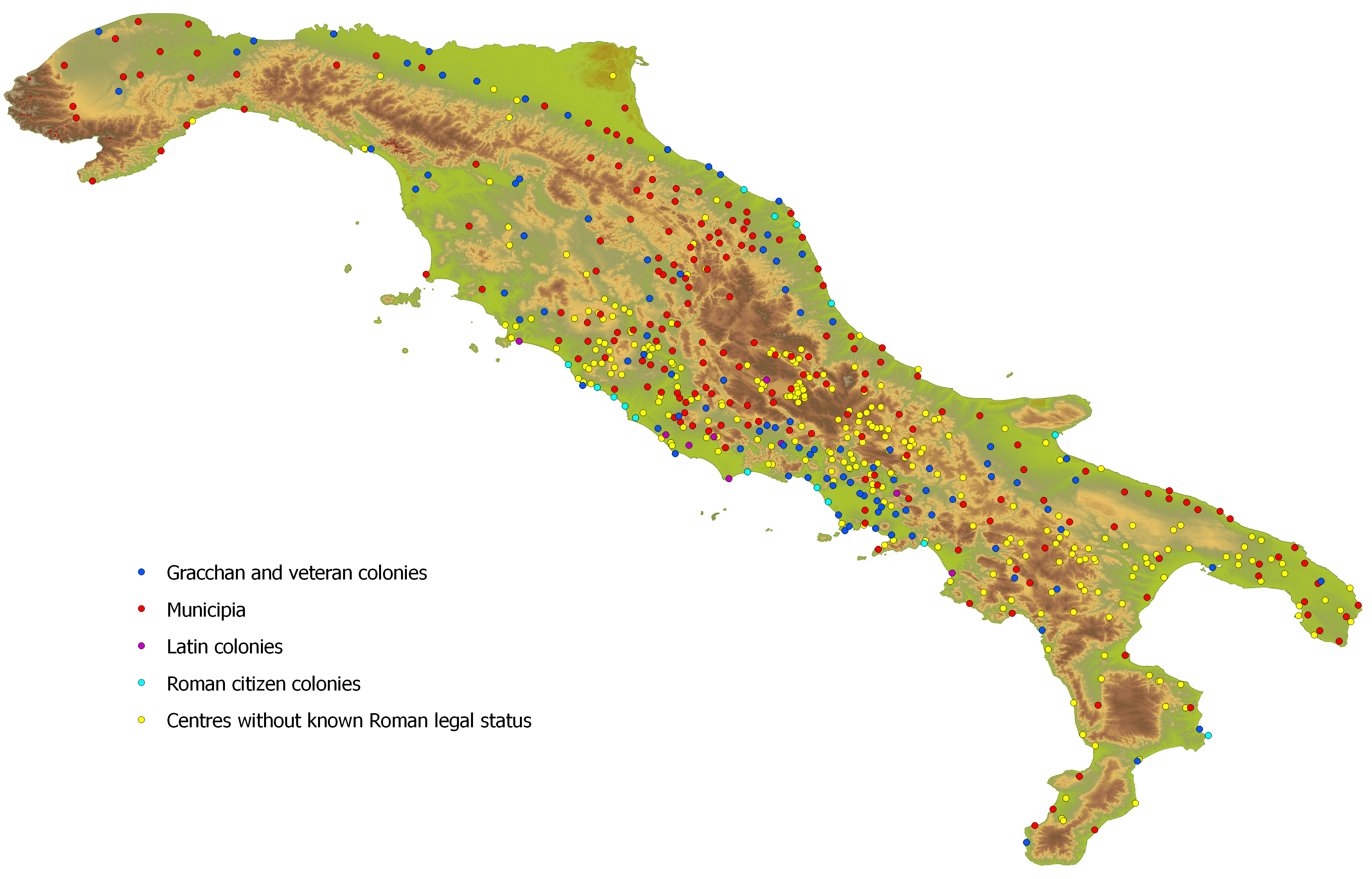
The structure of the database and the analysis of the data have been determined by the project's core research questions. Historians consider Rome to have subjugated most of the Italian peninsula in the period c. 350 to 250 BCE. Yet what might be described as characteristically 'Roman towns', with fora and specific types of monumental architecture, such as basilicas and amphitheatres, only became common in peninsular Italy from the later 1st century BCE in a process associated with the creation of veteran colonies and municipia (Figure 1). In fact, the majority of these towns had pre-Roman origins and therefore demonstrate several centuries of development before they reached their familiar Roman form. A key research aim has been to understand more about the processes that shaped the network of major settlements over time, from immediately before the Roman conquest through to the development of Roman towns during the early imperial period. GIS is well suited to the task of identifying changes in the spatial organisation of settlements on regional and supra-regional levels, and a database possessing a robust chronological structure can chart these changes over time.
Although the well-documented events of the Roman conquest have tended to dominate and influence the interpretation of the archaeological record, the rich evidence for pre-Roman settlement provides the opportunity to set the developments of the Roman period into context. Greek and Roman written sources describe at least 35 distinct peoples inhabiting Italy during the 4th and early 3rd centuries BCE. Apart from some Greek accounts of the Greek city-states of southern Italy (Purcell 1994), these non-Roman peoples have left no surviving accounts of themselves. Hence, we have only glimpses from the ancient texts, and almost exclusively through Roman or Greek eyes. As a result, knowledge of Italy's pre-Roman peoples is largely based on archaeological evidence, published in studies that are predominantly regionally based. A database of their major centres, encompassing the entire peninsula, permits the settlement histories of each region to be compared and contrasted so that broader developments may be identified and better understood.