Not only did field archaeology in the UK and Denmark branch out into two separate methodological approaches but the digital adaptations of spatial recording and management were from the very beginning also divided into two separate technologies: CAD and GIS.
Historically, Computer-Aided Design solutions had strong ties to archaeological fieldwork, and often to people or specialists with a background within cartography or surveying (Holst 2005). CAD was originally, as the name implies, developed as a designing tool, allowing for very precise and fast prototyping of machine parts and easy scalability between vector drawing on a computer and a real-world object. Dealing with objects on a designer-level, and even allowing for the drawing of three-dimensional vector lines, also meant that CAD became an essential tool for architects. It was, however, never meant as a mapping tool, and lacked the support of geographic coordinate systems, limiting its usage as an intra-site tool for archaeology. Relatively early applications including graphics databases were seen in the UK in systems like PLANDATA (Alvey and Moffett 1986), AEGIS, as used by the Scottish Urban Archaeological Trust (Rains 1989), and Hindsight (Alvey 1993), which extended the capabilities of AutoCAD to produce composite plans and three-dimensional models from single-context plan elements.
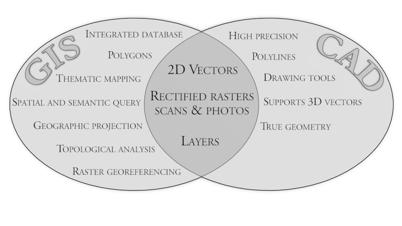
Geographic Information Systems, on the other hand, were created as tools for more than simply drawing vector lines and, as the name implies, were 'born' geographically aware, with the ability to present spatial information by applying a map projection. Furthermore, unlike CAD, GIS included support for topology and thereby tools for calculation and analysis of spatial functions, which were very promising for archaeological investigations of spatial distributions and topographical analysis (Conolly and Lake 2006). GIS was primarily adapted through Desktop Mapping solutions, which provided the integration of semantic content or 'information' and allowed for the association with a geographic vector representation of an object or feature. The support for georeferencing rasters also meant that traditional hand-drawn excavation plans could be scanned and managed by the GIS systems, allowing for stacking or layering drawings – providing coherency and explorative capabilities to vast amounts of spatial data, with little other effort than scanning. Combined with vectorisation tools, GIS would appear superior to CAD, were it not for its basic premise; that everything is represented as a geographic projection onto a surface, meaning that three-dimensional data had to be contained within a two-dimensional visualisation.
The motivation for choosing either technology not only relates to the traditions and professional background of the people involved, but also to an issue of availability and affordability of the software, which early on was limited to often expensive proprietary solutions (Holst 2005). Interestingly, there are also clues to the rationale behind the choice of either technology for representing spatial recording if we examine the ideal of different archaeological methodologies or traditions. Specifically the choice between GIS or CAD very well illustrates how the choice of technology is tied into tradition-related preconditions; the ideal, goal or end-product of our documentation.
Common to both technologies, as they are implemented in archaeology, is the goal or de facto standard of representing archaeological features, contexts and finds as vector geometries; points, lines and polygons (see Figure 1). It is, however, important to recognise that, apart from perhaps 3D vectors, GIS and CAD have been applied as equivalent to our analogue procedures, hand drawings, and as the development of both archaeological methodologies and spatial technologies took place in the same time span, they have inevitably had a profound impact on each other. Large-scale single context planning benefits immensely from proper computer power and digital tools to handle what otherwise would be extremely fragmented recording. On the other hand, the methodology of excavation by stacking two-dimensional layers is directly comparable to the representation that was possible - or limited - by standard GIS and CAD.
Due to its embedded database capabilities, GIS would appear as the best choice, seen from the perspective of enhancing our traditional drawing with semantic information, and it is perhaps the most critical limitation to CAD, which had to rely on external database solutions. Unfortunately, the GIS concept in its most basic sense is limited to storing associated data in a single table, corresponding to spatial objects in a one-to-one relationship. Any archaeological registration system will show that this is not the real-world situation! The eventual outcome is the splitting up of spatial and textual documentation, potentially rendering either useless without the other.
Internet Archaeology is an open access journal based in the Department of Archaeology, University of York. Except where otherwise noted, content from this work may be used under the terms of the Creative Commons Attribution 3.0 (CC BY) Unported licence, which permits unrestricted use, distribution, and reproduction in any medium, provided that attribution to the author(s), the title of the work, the Internet Archaeology journal and the relevant URL/DOI are given.
Terms and Conditions | Legal Statements | Privacy Policy | Cookies Policy | Citing Internet Archaeology
Internet Archaeology content is preserved for the long term with the Archaeology Data Service. Help sustain and support open access publication by donating to our Open Access Archaeology Fund.