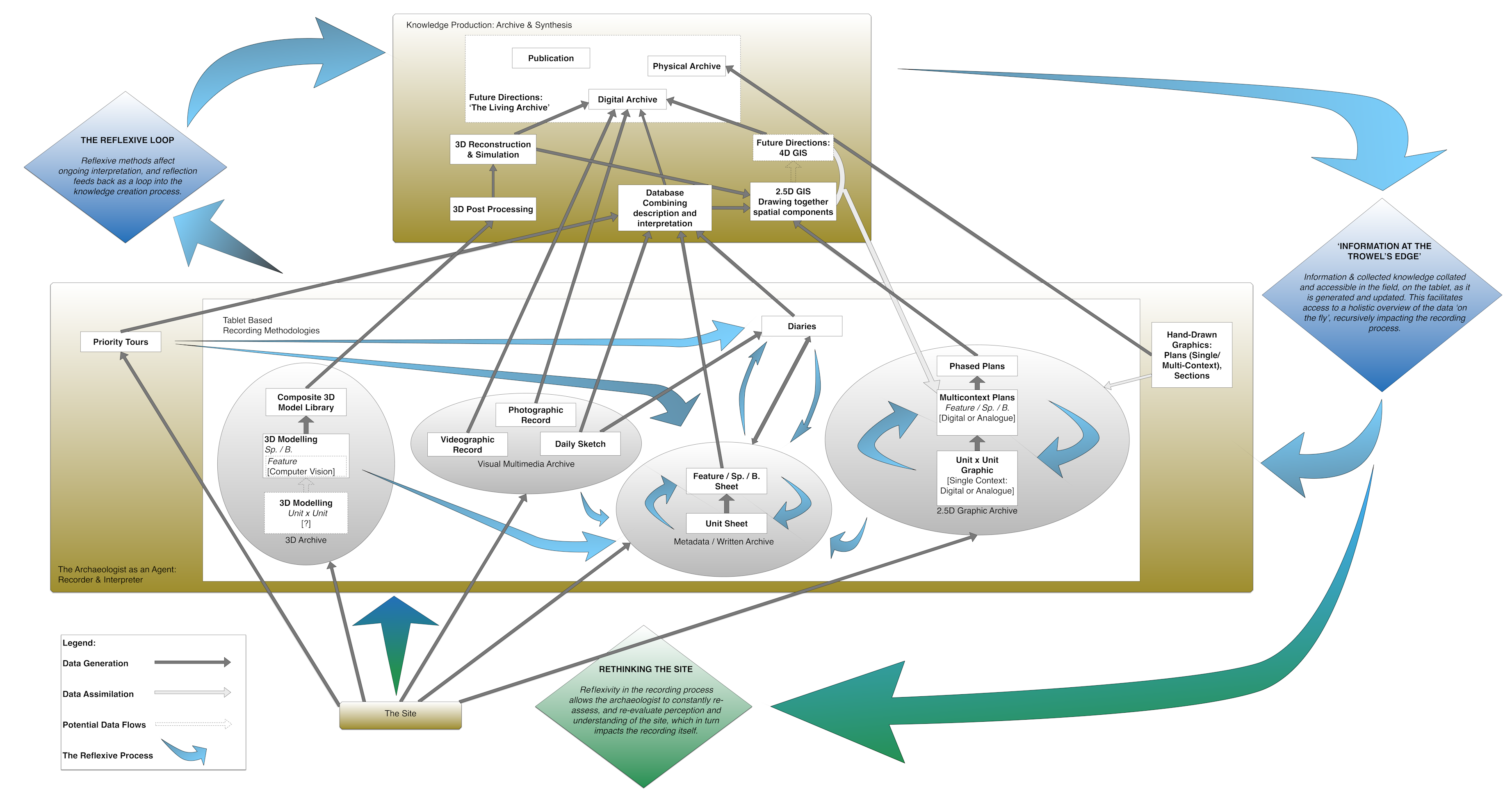
The main impact that became apparent once the team began to get to grips with the tablets as a site tool was the accessibility of a range of different 'types' of data to the excavator, whilst in the field. The concept of 'information at the trowel's edge' suggested that the tablets might have considerable potential as a 'reflexive tool', something that members of the team rapidly began to utilise. In order to explore this further, this paper will focus upon how we see the tablet fitting into the reflexive process of excavation as it has developed at Çatalhöyük. Figure 1 effectively outlines the recursive reflexive recording process and its relationship to the digital recording that we have been implementing at Çatalhöyük.
At the foundation of this hierarchy of knowledge production is 'The Site' itself, which can be seen (perhaps fairly conventionally) as a primary resource for the generation of interpretations and knowledge for those who interact with it. In terms of the excavation process at Çatalhöyük, the next tier is 'The Archaeologist' as an agent for observing, recording and interpreting the site. In this sense 'archaeologist' refers to any team member, of any specialism, that has some input into the generation of data and its subsequent interpretation. Finally, above The Archaeologist in the hierarchy are the various strands of output and dissemination of data and its interpretation, most commonly in the form of the archive and various tiers of publication, these being ultimately the physical manifestation of the team's 'Generation of Knowledge'. Within the structure of this flow of knowledge from the site to the various project outputs, 'The Tablet' potentially nests at the heart of The Archaeologist's recording kit as an 'archaeological tool'. The diagram (Figure 1) explicitly recognises the role the tablet has to play in this process, as we increasingly strive to make the site paperless.
But what makes the tablet so useful from a reflexive standpoint? Why are there so many blue arrows linking the various digital tasks that can be performed on the tablets?
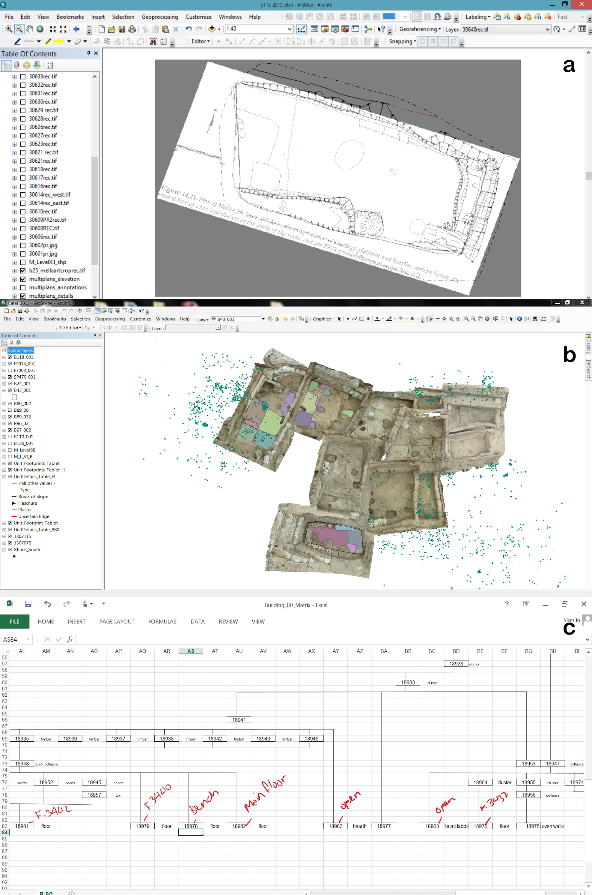
As already noted, the main application of the tablet is as a tool for producing Single Context graphics, straight into the intra-site GIS. The project's implementation of a single context excavation and recording methodology means that the traditional 'paper' (pre-tablet) graphic archive has a fairly standard and recognisable structure:
In this paper-based system, before the use of tablets, only the lower-order plans would be available to the excavator in the field as they excavate. However, as excavators our understanding and ultimate interpretation of a stratigraphic unit is generally informed by its context within the sequence and in relation to the units that surround it spatially. As noted above, one possible critique of the single context recording system is that by atomising the graphics stratigraphically, the excavator effectively obliterates this context in the primary archive. Almost all of the higher-order grouped plans are actually synthesised off-site during the post-excavation process; this is especially true of phase plans, which form by far the most common interpretative output across the discipline. This can become a problem, particularly on a complex site such as Çatalhöyük, where the stratigraphy is so complicated and often 'micro' in scale. Attempting to hold the contextual information in one's head that one needs as an excavator in order to form an interpretation about what one is recording can be a daunting task, requiring a degree of skill and experience. Furthermore, in the classic paper system, when one needs to find information about a related unit, often that information is dispersed physically across several folders of unit sheets and registers, and in the case of photographs, off-site, upon the computers in the lab.
By contrast, in the tablet-based workflow outlined above, all of this traditional information has been preserved within the structure of the GIS; this was always a key goal in the development of these workflows. In addition to the tablets' on-board GIS, it has also been possible to make use of the full site archive and database suite. The tablets with their on-board GIS clearly allow for the integration of both old and new data. Having this higher-order, contextual information available, even being able to generate this kind of content on the fly using the intra-site GIS, has proved immeasurably useful to us as excavators in informing our initial interpretation 'at the trowel's edge'.
At Çatalhöyük the intra-site GIS was developed within the reflexive framework as a collaborative and bottom-up effort from the beginning. Both archaeologists and specialists were involved in the shaping of the geodatabase, creating a flexible tool that has been tailor-made for the site. The ÇRP GIS developed as a highly contextual system, a 'positioned' (Haraway 1991) archaeological GIS, not 'fixed or given' but constantly reworked through archaeological practice. Its structure has grown and changed through the years; new parts were added while others were removed in accordance with the needs of the site. The most recent modifications were made to facilitate the use of the GIS on tablets as a tool for primary recording on site.
Additionally, the adoption of the tablet enhanced the ability of the GIS to be used as a reflexive tool. Above all, the tablets allow the GIS to be 'situated' in the field, thus reducing the distance between the technology and the archaeology and promoting a more intense utilization of the system by the archaeologists. Through the tablets archaeologists are able to handle the GIS from within the 'trench', in front of the archaeological feature, from 'down below'. Moreover, using the GIS at the 'trowel's edge' bolstered a bottom-up approach to the way technology is implemented at Çatalhöyük and promoted a more urgent and multivocal dialogue between the different components of the project. The debate around the adoption of the tablet in the field and the process of going 'paperless' has prompted a productive discussion between archaeologists and specialist that puts the GIS as a system of knowledge production at the centre, helping to fulfill the aim of carrying on a 'relentlessly reflexive' GIS practice (Schuurman 1999, 13).
Thus the ÇRP GIS is developing through what Pickering defined as a 'mangle of practice' (Pickering 1995), through a regular dialectic between archaeologists and GIS specialists (human-agency) and the GIS software (non-human agency). This is a dialectic of 'resistance and accommodation' (Sheppard 2005, 13), of pushing and bending the technological tool to fit archaeological practice and a reflexive agenda. The result has been a hybrid GIS practice that incorporates different approaches (quantitative, qualitative, 3D, 2D, post-excavation, primary recording on site) and has created something new, where boundaries are crossed and 'creative connections' are fostered (Kwan 2002; 2004). Since the adoption and implementation of the 'next generation' recording technologies outlined above, with an emphasis upon the reflexive ethos of the project, it has become necessary to focus upon a key question: if we as a project are to attempt to remain critically self-aware as we evaluate and adopt a comprehensive digital approach to reflexive field recording, how do the tablets and other potential digital modes of recording fit into the suite of reflexive methods employed at Çatalhöyük?
Internet Archaeology is an open access journal based in the Department of Archaeology, University of York. Except where otherwise noted, content from this work may be used under the terms of the Creative Commons Attribution 3.0 (CC BY) Unported licence, which permits unrestricted use, distribution, and reproduction in any medium, provided that attribution to the author(s), the title of the work, the Internet Archaeology journal and the relevant URL/DOI are given.
Terms and Conditions | Legal Statements | Privacy Policy | Cookies Policy | Citing Internet Archaeology
Internet Archaeology content is preserved for the long term with the Archaeology Data Service. Help sustain and support open access publication by donating to our Open Access Archaeology Fund.