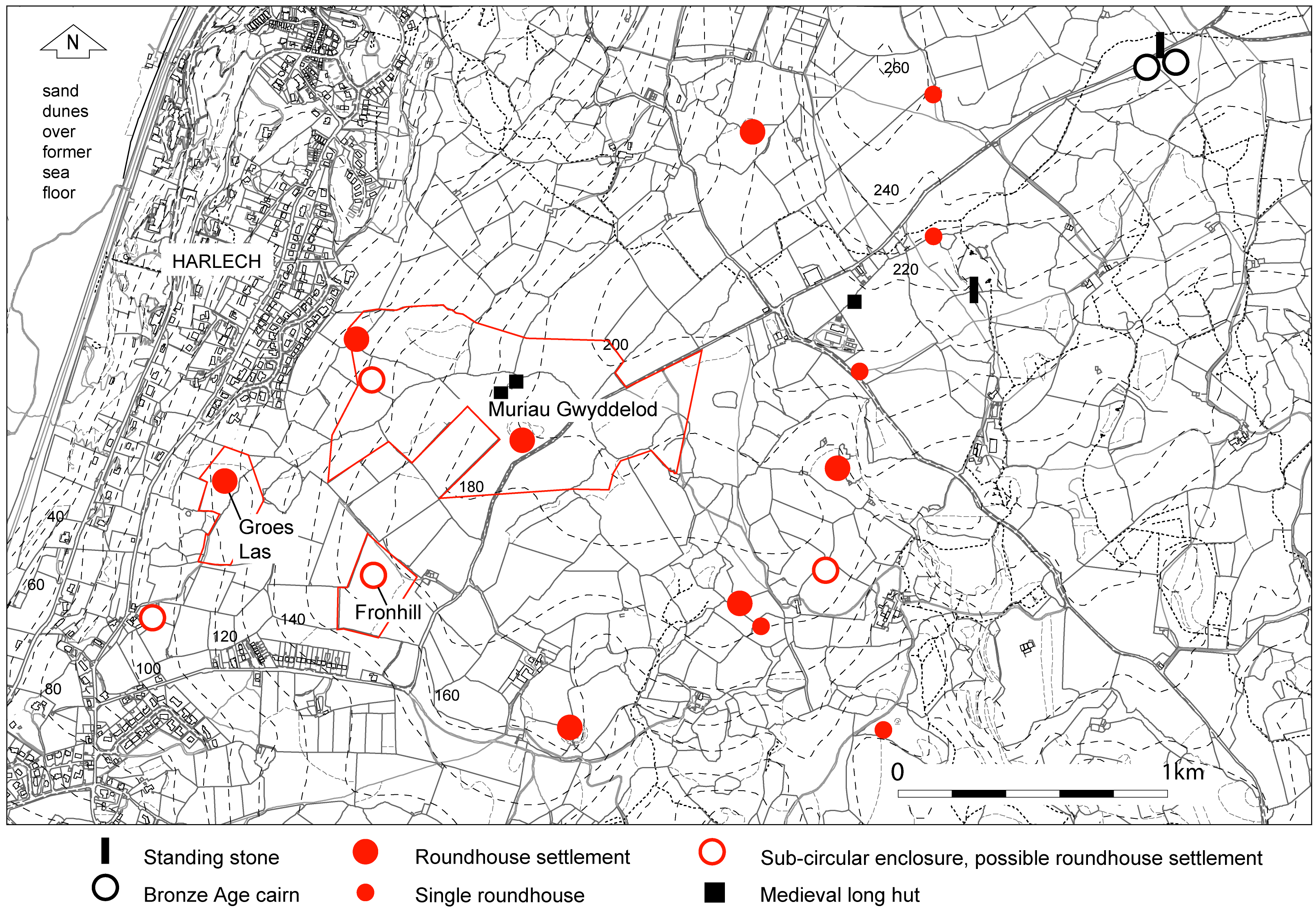
The third area investigated lies on the west-facing slope and summit of a ridge, between 100–200m OD, overlooking Cardigan Bay above Harlech centered at SH 506383 (Figure 14). It is much larger at c.22.5ha (56 acres) and more complex than the two previous areas, including three probable prehistoric settlements, two long huts, and an extensive area of field system. There are two smaller, outlying areas, Fronhill and Groes Las, each with a probable enclosed roundhouse settlement set within fragments of the wider field system. The best known of the settlements, on the summit, is Muriau Gwyddelod ('The Irishmen's Walls'). Each of the three areas is protected as a Scheduled Ancient Monument and part of the area is a Site of Special Scientific Interest. The whole area has not previously been surveyed, but the main settlement itself has been planned (Bowen and Gresham 1967, 199). The area is just part of a wider surviving, if fragmented, prehistoric landscape on the upland plateau of Ardudwy, studied by Kelly (1982). Kelly subsequently excavated two settlements of the mid- to late first millennium BC at Moel y Gerddi and Erw-wen, the latter lying only about 3km to the north-east of the present study area (Kelly 1988). That project included a palaeoenvironmental study (Chambers and Price 1988), which provides essential information for the present work.
The bedrock here is igneous and impervious and the soils are thin and stony over the summit but deeper on the slopes. They are brown earths of poor agricultural value although the better-drained slopes have been fairly intensively used for agriculture since prehistoric times. The previous palaeoenvironmental study showed that the area was once covered in woodland, which was gradually cleared by human activity starting in the Mesolithic period, only approaching its present appearance in the medieval period (Chambers and Price 1988). The soil developed beneath the woodland would have been of good quality and more favourable to agriculture, but gradually declined in quality over a long period due to depletion of humus. What was once a well-settled area with an extensive pattern of homesteads and fields, dating from at least the middle of the first millennium BC, gradually became suitable only for pasture. This meant that many features of prehistoric land use still survive although fragmented by some areas of post-medieval clearance.
Internet Archaeology is an open access journal based in the Department of Archaeology, University of York. Except where otherwise noted, content from this work may be used under the terms of the Creative Commons Attribution 3.0 (CC BY) Unported licence, which permits unrestricted use, distribution, and reproduction in any medium, provided that attribution to the author(s), the title of the work, the Internet Archaeology journal and the relevant URL/DOI are given.
Terms and Conditions | Legal Statements | Privacy Policy | Cookies Policy | Citing Internet Archaeology
Internet Archaeology content is preserved for the long term with the Archaeology Data Service. Help sustain and support open access publication by donating to our Open Access Archaeology Fund.