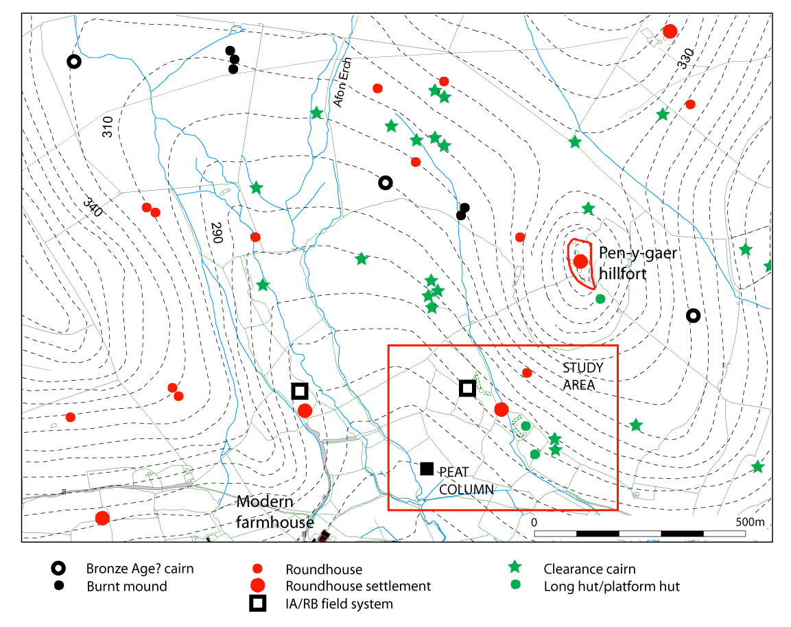
The excavation at Cwm Cilio indicates some clearance of woodland as early as the Later Mesolithic period. Another period of clearance took place in the Early Bronze Age, possibly indicating the first agricultural use of this area, prior to establishment of the field system. The complex of settlement features has not been excavated so interpretation relies on typological comparison with dated examples elsewhere. The earliest identifiable settlement, perhaps of Middle Iron Age date, consisted of roundhouses incorporated within the fields and possibly associated with the small hillfort of Pen-y-gaer, on the adjacent hilltop. The compact, rectilinear enclosed settlement is expected to be of Later Iron Age date, perhaps, like that at Bryn Eryr, Anglesey, occupied into the Romano-British period (Longley 1998). To the east of the roundhouse settlement is a larger, sub-rectangular enclosure containing two small roundhouses and a single rectangular platform. The latter is suggested to be the site of a medieval timber platform house by comparison with similar platforms at the settlement of Gesail Gyfarch, Penmorfa, 12km to the east, occupied from at least the 13th to 15th century AD (Roberts 2006, 117–120). The radiocarbon dates from the soil buried beneath the excavated field boundary were from the Later Mesolithic and Early Bronze Age periods, deriving from much earlier episodes of woodland clearance. However, intriguingly, cultivation had been taking place prior to the construction of the excavated field boundary; the period of its commencement is unknown.
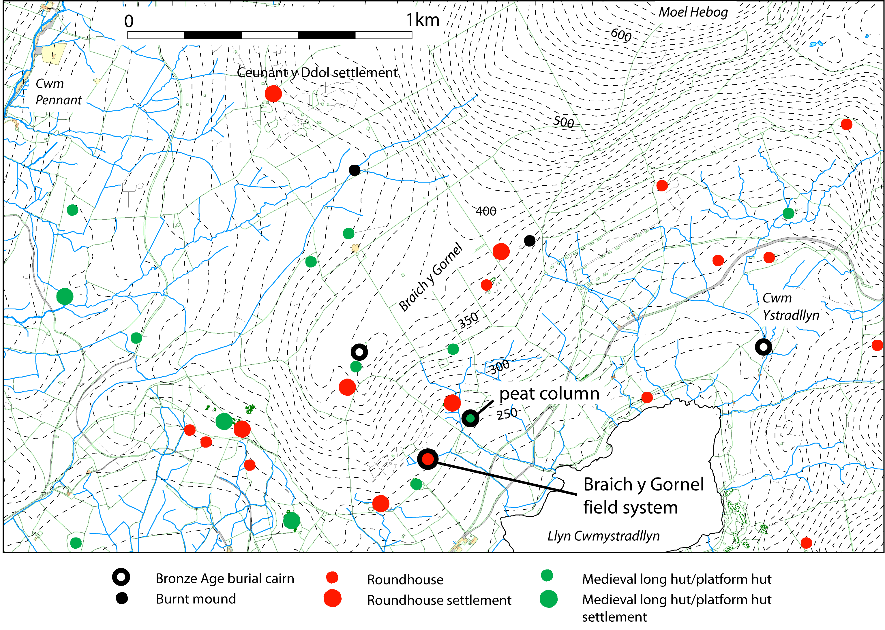
Although the central settlement at Braich y Gornel had been excavated in 1950 and 1954, it produced no dating evidence. The lack of Romano-British material from the nucleated part of the settlement suggests it might be of pre-Roman date and is of a Late Iron Age type. The larger outlying roundhouse would be expected to precede the nucleated settlement and perhaps be of Middle Iron Age date, by comparison, for instance, with the similar roundhouse S4 at the unenclosed settlement of Cefn Cwmwd, Anglesey (Cuttler et al. 2012, 52–58). The only radiocarbon date obtained as part of the current project came from a soil that must be contemporary with the use of the fields: this is of the Middle Bronze Age and has been interpreted as the product of earlier activity on the hillside.
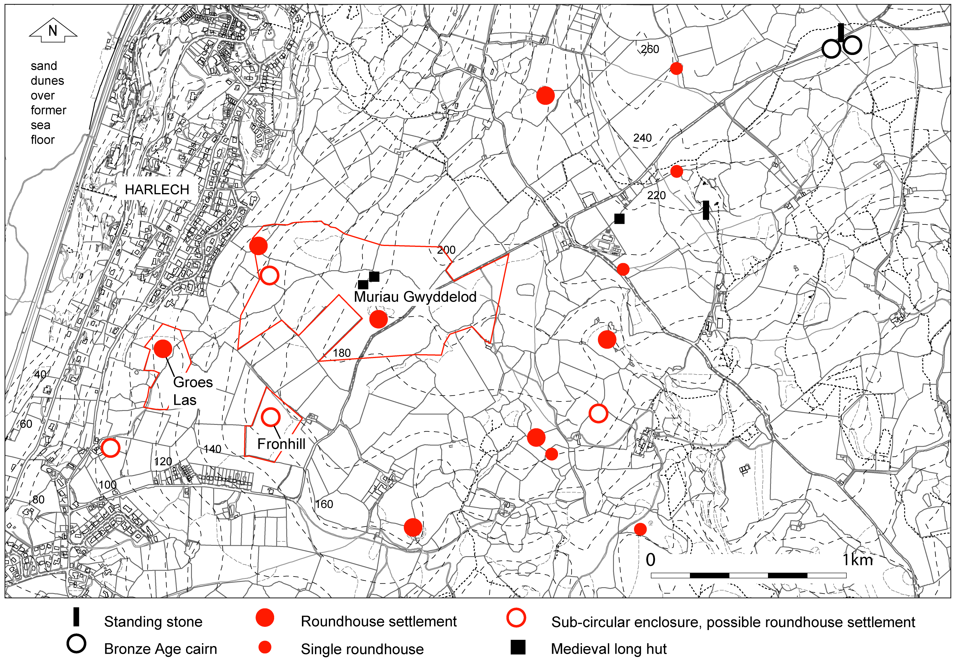
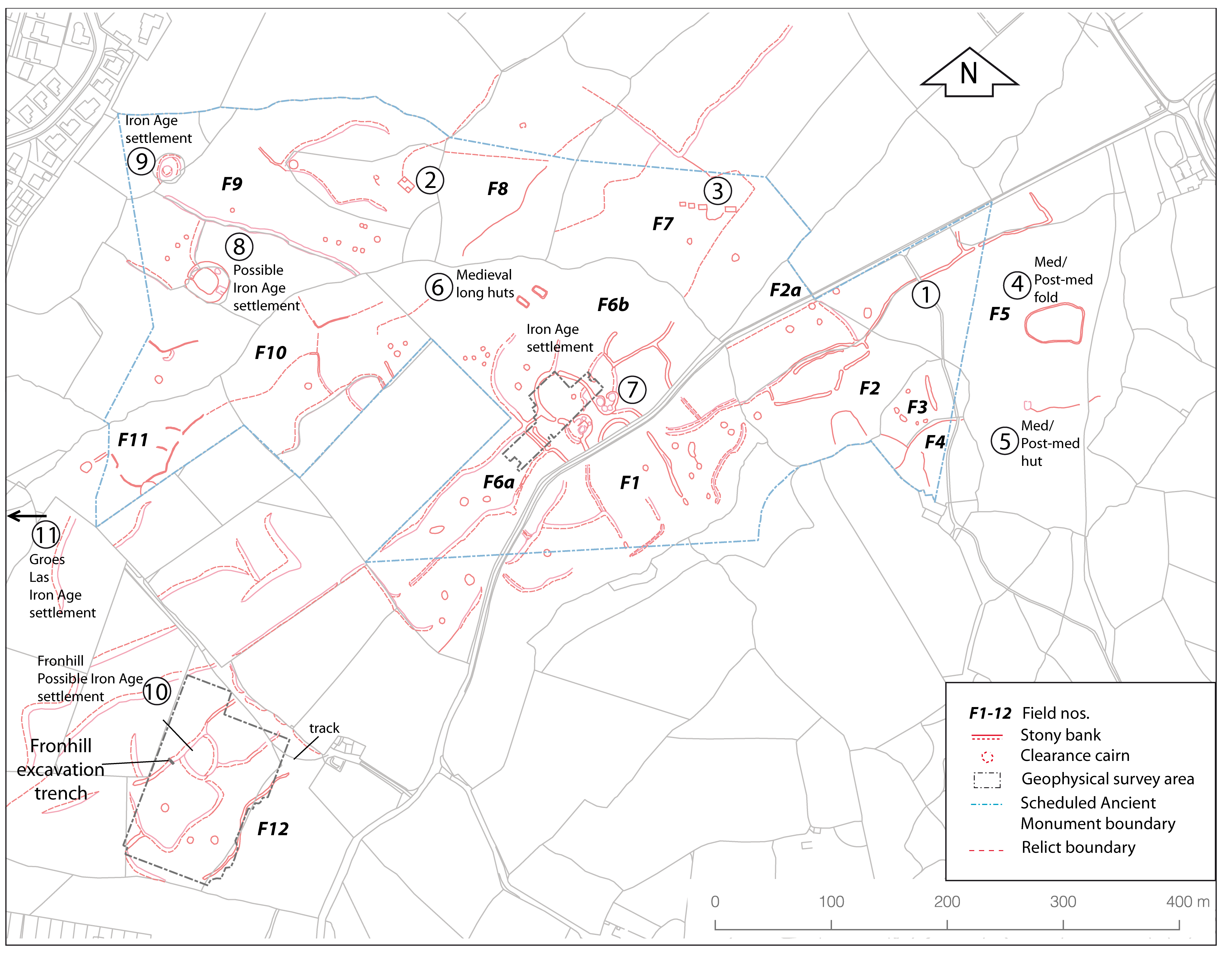
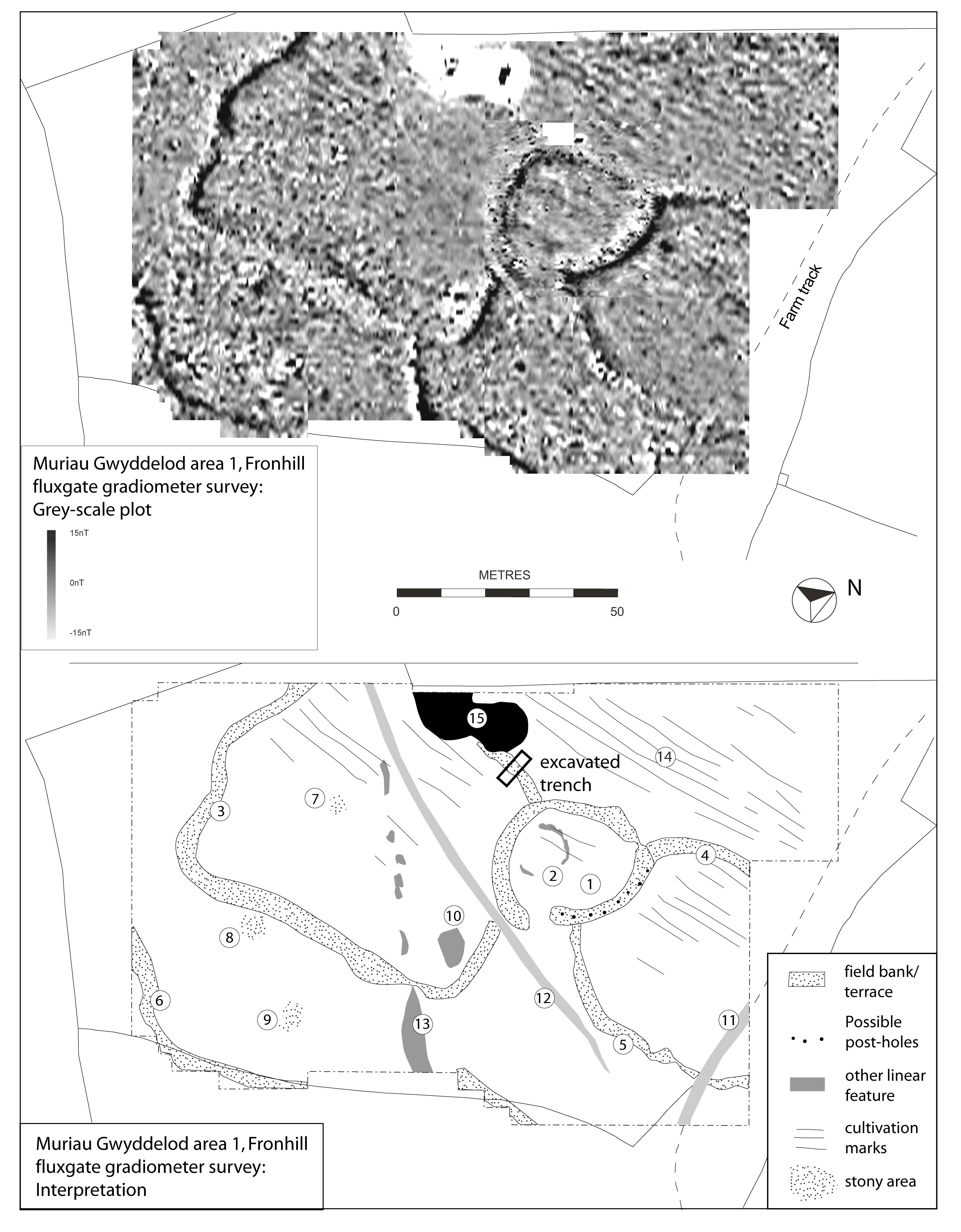
There have been no excavations at Muriau Gwyddelod, apart from the present work, and no chance finds, so interpretation and dating must rely on comparative evidence. The extensive relict landscape here contains several roundhouse settlements, of which the most readily identifiable are sub-circular 'concentric enclosure'-type settlements and two of these within 5km have previously been excavated (Kelly 1988). Both of these had a central roundhouse within a concentric enclosure and were initially constructed as timber-walled houses, later replaced with stone walls, and both were occupied around the middle of the first millennium BC. The one closest to Muriau Gwyddelod and in a similar topographic setting, that of Erw-wen, was the earliest, beginning possibly c.800 cal BC, with occupation ceasing by the middle of the first millennium BC. The other, Moel y Gerddi, at a slightly higher altitude, continued in use until about the 4th century BC. The two sub-circular enclosures at Muriau Gwyddelod, together with those at Fronhill and Groes Las, are similar in form to Erw-wen and Moel y Gerddi. Both the northernmost enclosure at Muriau Gwyddelod (Figure 14 and Figure 15, F9) and that at Groes Las (Figure 14 and Figure 15, F11), have central roundhouses within concentric enclosures. It is plausible the two sub-circular enclosures without visible roundhouses, at Muriau Gwyddelod and Fronhill, could have enclosed a central timber roundhouse, evidence for which is currently lacking. However, there is evidence that these enclosures were later cleared and re-used: at Fronhill there is ground evidence of terracing into the slope within the enclosure and possible geophysical evidence for at least one roundhouse (Figure 16). The two radiocarbon dates from the excavation of the boundary at Fronhill were from the Earlier Mesolithic and the Middle Neolithic periods, and are unrelated to the field system, although they show that there was earlier clearance and, by inference, probably stock grazing too.
The central settlement at Muriau Gwyddelod consists of two nucleated settlement areas attached to a larger sub-circular enclosure. It is likely that this enclosure, the interior of which is terraced level, began life as a 'concentric enclosure'-type settlement with a central roundhouse and that this was later replaced by the two smaller courtyard house-type homesteads. This would correspond to the pattern of the surrounding fields/paddocks, which is focused on the larger enclosure, concentric to, and radiating from it.
The radiocarbon dates suggest a limited amount of woodland clearance as early as the Later Mesolithic and at Fronhill the clearance may well have been related to the creation of pasture. Areas of such better grass pasture would have been identifiable as being more fertile ground and thus likely to be selected for cereal cultivation. In the areas of the best soils it may be only after the ground was broken for cultivation and subject to prolonged use that subsoil stones began to be exposed and cleared and used to create boundaries. However, in upland areas with shallow soils above glacial deposits, as in North Wales, stones would need to be cleared from the commencement of cultivation. This scenario has been identified in North-West England, in the Lake District uplands, indicating that groups of cairns ('cairn fields') were created alongside the earliest settlements when cultivation began in unenclosed plots. Subsequently these developed into 'proto-field systems' and later into more formal field systems (Quartermaine and Leech 2012, 328–332).
Later use of the fields at Cwm Cilio and Fronhill has removed most traces of early cultivation. At Braich y Gornel there was faint geophysical evidence of possible single-direction ploughing along the contour and at Cwm Cilio, in a small area that was almost certainly unaffected by post-medieval cultivation, the soil micromorphology indicated a ploughed soil. This could belong with the Iron Age/Romano-British settlement but could equally belong to later re-use of the fields associated with the small rectangular building nearby, suggested to be of medieval date. At Fronhill the geophysical survey did show that a major phase of ploughing over the whole area, with furrows c.2.5m apart, pre-dated the walls of the existing large rectangular fields of more recent date but post-dated the early field system. Similarly spaced furrows, pre-dating the existing stone walls, have also been recorded in upland at Hengwm, Meirionnydd, interpreted there as the breaking of the ground prior to stone clearance and construction of new walls as part of 19th-century enclosure and agricultural improvement (Smith and Hopewell 2007).
Any general interpretation of the boundaries, based on the excavated evidence, must be cautious because of the small size of the areas investigated. In each case the fieldwork indicates that the early boundaries were not barriers designed to enclose or exclude stock and this accords with evidence elsewhere (Fowler 1983, 110–111). At Braich y Gornel the boundaries were very insubstantial lines of boulders, while at Fronhill and Cwm Cilio they were substantial stony banks that sealed earlier soils. Both the latter boundaries might have supported hedges that could have made them stock-proof but identification of hedges is difficult to prove by excavation alone (Robinson 1978). Those here are soil-less stone banks and the palaeoenvironmental study showed a general absence of plant species indicative of hedgerows. Some form of timber fencing could have been present but could only be demonstrated by more extensive excavation.
The excavated boundary at Braich y Gornel was very insubstantial so functioned more as a deliberate marking-out feature rather than as a dump of clearance stones. The fields there lie on a hill slope which has only superficial glacial deposits over the shale sedimentary rock and therefore there was no development of stony banks, terraces or cairns. At Cwm Cilio, the earliest phase of the boundary also appears to have been just a marking-out feature, being simply a low heap of subsoil, while at Fronhill the boundary was, from the start, a built stony bank. The evidence in all three cases therefore is that the fields were deliberately laid out from the start but that at Fronhill and Cwm Cilio the boundaries were subsequently added to by the addition of clearance stones. This appears to have derived from continuous use, although at Fronhill there was a late phase of addition of larger stones to the bank. This could relate to medieval re-use of the fields, possibly associated with the dumping of clearance stones as cairns within the fields.
Although the grassed-over early field banks and terraces are quite slight features today, the geophysical survey at Cwm Cilio indicated that all the early boundaries had considerable quantities of stone incorporated within them. A rough calculation was made of the amount of stone revealed in the trench at Cwm Cilio. The trench was 1.4m wide, with the bank revealed within it 2.4m wide and estimated to originally have been c. 1m high, from the amount of collapsed stone. Using, for comparison, the standard constructional weight for granite gravel, less an expansion factor of 0.6, gives a weight of 4.3 metric tonnes, in this one small trench. The boundaries of the whole field system therefore comprised many thousands of tons of clearance stone, showing what a major investment of time and energy was involved in the creation and maintenance of the fields.
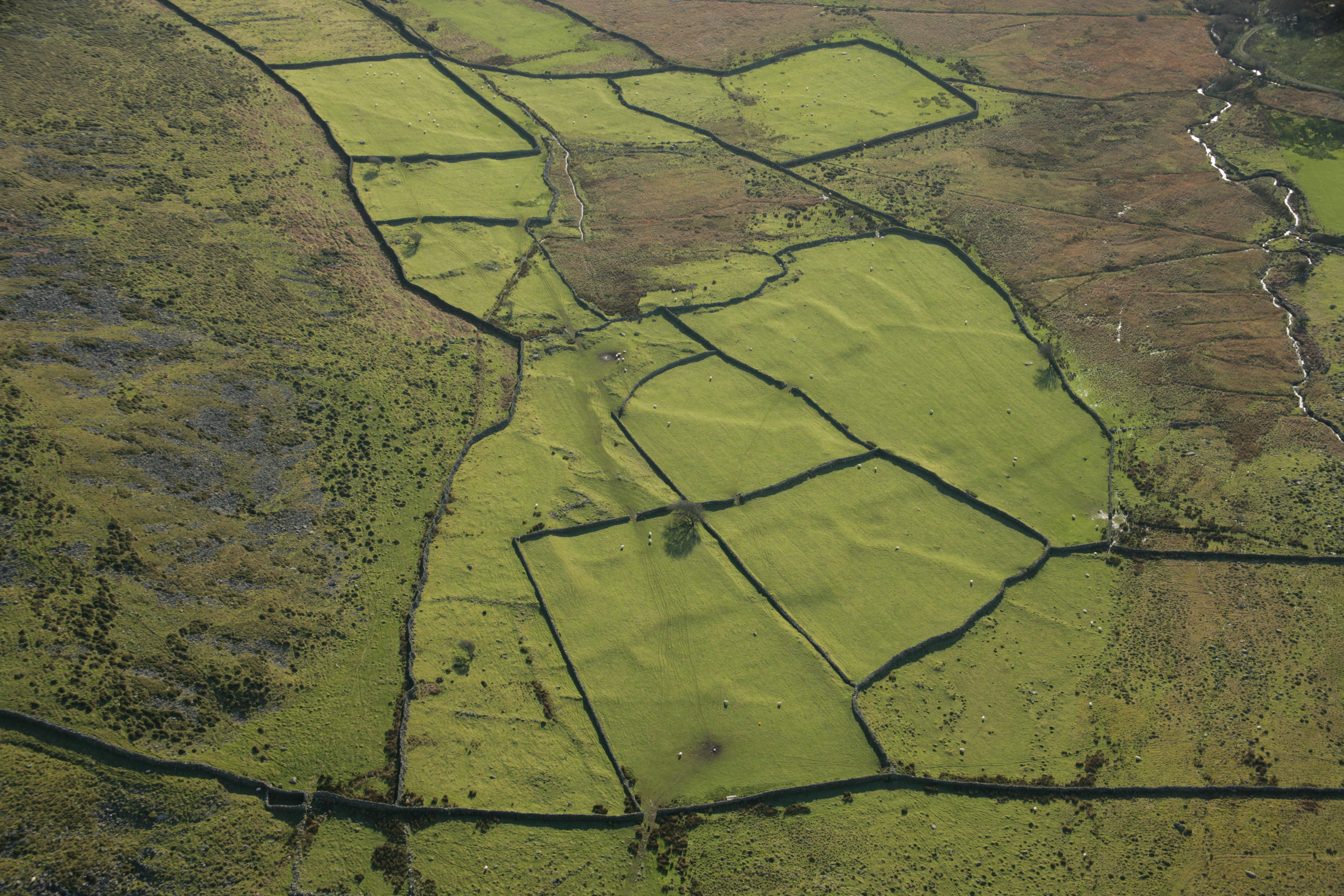
Accumulation of soil on the uphill side of field boundaries as 'lynchets' is present in all three field systems but only at Cwm Cilio is it substantial enough to be called 'terracing' and here it has even survived post-medieval ploughing. The way that such lynchets form, as a result of pre-mechanised cultivation, has been investigated by the study of field terraces in Belgium compared to rates of actual accumulation during primitive farming in Ethiopia, which showed that rates of accumulation were related to the steepness of the slope. These terraces were not prehistoric but were estimated to have been under cultivation for several centuries, some perhaps since the Roman period (Nyssen et al. 2014). Although Cwm Cilio and Braich y Gornel lie on similar angles of slopes, the amount of accumulation at the latter is insignificant, implying that very little cultivation ever took place. At Fronhill, there was negligible slope but the soil above the boundary is deeper, showing that the boundary did serve as a barrier that retained soil. The terracing of the field system at Cwm Cilio, a type of system typical of those associated with enclosed settlements of the Iron Age and Roman periods in North Wales, can be considered as a 'developed' system of farming, indicating intensive and sustainable use of a small area of land. Soil micromorphological and other analyses of Late Bronze Age/Early Iron Age lynchets in Denmark showed that soils had been improved by the application of household waste, manure, and soil from wetland and heathland areas (Nielsen and Dalsgaard 2017). The stone-walled post-medieval fields that were overlaid on the Cwm Cilio fields were cultivated but it is noticeable that this did not result in lynchet accumulation (Figure 3). Study of hillslope erosion after the expansion of agriculture into steeper-sloping land during the medieval period in one area of Central Europe showed that erosion was greatest after initial forest clearance but after that cultivation techniques led to sediment storage (Larsen et al. 2016). The earlier phase of cultivation recognised in the soil below the Cwm Cilio boundary, associated with an early second millennium BC date, might be comparable to the cultivation associated with Beaker pottery which caused erosion and build-up of valley sediments in the South Downs (Bell 1981).
The fields at all three of the studied locations are typified by their arrangement around a focal settlement area. There is no overall pattern and this is typical of field systems in the very varied upland topography where only limited areas are suitable for cultivation and there are no extensive co-axial field systems as found in much of England, including the South Downs and Dartmoor (Field 2001). Nevertheless, the field systems around Muriau Gwyddelod cover a considerable area, belonging to more than one settlement but the overall pattern suggests organic rather than planned development. The field shapes are very variable but the best-preserved complete examples at each are within the range of 0.2–0.3ha (0.5 to 0.75 acre) and this falls within the range of sizes of early fields in extended field systems of the South Downs of England (Fowler 1983, 108).
The isolated and fairly complete field systems at Cwm Cilio and Braich y Gornel provide an indication of the area of arable land needed for a settlement. At Braich y Gornel, a single farmstead, the area is about 1.5ha (3.5 acres), while at Cwm Cilio, with a small settlement of four houses, the area is 7 ha (17 acres). However, the settlements at all three field systems would have had access to extensive upland grazing.
Both Cwm Cilio and Braich y Gornel are in areas on the edge of upland, above 250m (800ft) OD and close to the limits for arable cultivation. They both occupy and exploit a narrow ecological zone between steep, rocky slopes and the wet, glacial boulder-strewn valley floors. The soil micromorphology shows that both were in areas of somewhat better-quality soil, being better drained and less acidic than the wider, surrounding area. The close relationship between the location of Later Iron Age settlement, including that at Cwm Cilio, and areas of better soils, has already been recognised. In a study of 156 enclosed settlements, 80% were on good, well-drained soils (Johnson 1978). Use of this zone is repeated widely throughout the region and at Cwm Cilio there is a similar, but less well-preserved, small settlement and field system close by on the opposite side of the valley (Figure 2) and several others in similar topographic situations around this block of hills, chiefly in south-facing locations. The present-day farm of Cwm Cilio depends on cattle and sheep rearing, with only a small area of improved pasture fields, allowing some grass fodder cutting, but with access to a large area of rough upland (summer) pasture. In the medieval and post-medieval periods the farming in this region would have been more self-sufficient, with some dairy and arable, oats being the main staple (Caseldine 1990; Jenkins et al. 1962). This self-sufficiency would have been even more evident in the enclosed settlement, as exemplified at the similar enclosed settlement of Cefn Graeanog 2, only 5km to the north-east of Cwm Cilio (Fasham et al. 1998, 2–113). That settlement spanned c.AD 50 to AD 350 but had throughout an economy of mixed farming (Table 18) with a considerable cereal output, dominated by spelt wheat and some barley. Its long existence shows it was a productive and sustainably managed farm and the same is probably the case with Cwm Cilio. Evidence from comparable studies of Celtic fields in the Netherlands over the long timespan of the Late Bronze Age to early Roman period showed that in the Late Iron Age there was a marked change from a former extensive system with long fallow and low manuring to an intensive system with more tillage and higher manuring (Spek et al. 2003).
The fields at Braich y Gornel are rather different, with no evidence of lynchet formation and minimal boundary structures suggesting that the settlement had an emphasis on stock farming with only limited cultivation. Fronhill is at a somewhat lower altitude than either of the other two field systems, and forms just one element of an extensive area of Iron Age settlement and field systems. In this area farmsteads occur about every kilometre (Figure 14) and within this dense area of settlement the fragments of surviving early fields suggest a pattern of agglomeration, with 'infields' laid out around each farmstead, possibly originally separated by some open areas but gradually expanding until the whole area was occupied.
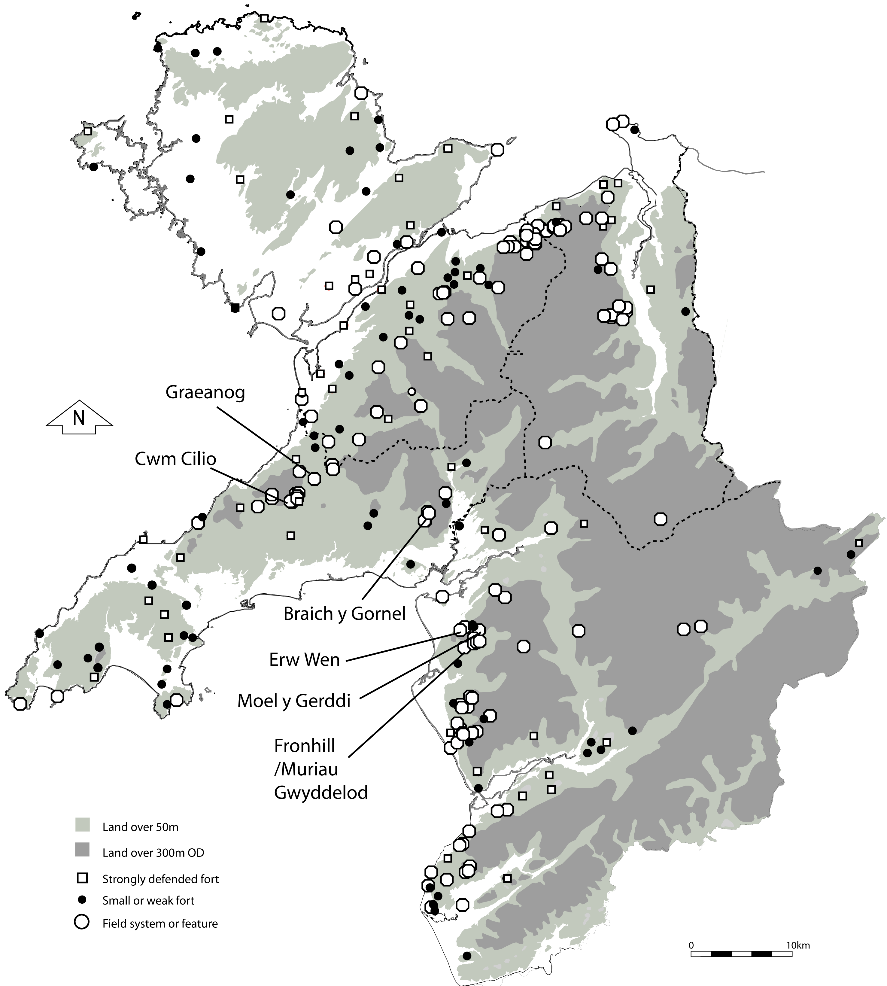
The pattern of the fields and the type of settlement present at all three systems suggests they all belong to the first millennium BC but are likely to have continued little changed into the first millennium AD. Cwm Cilio is noteworthy because it lies close to, and probably is associated with, the major hillfort of Pen-y-gaer. This fort, in a very strong and visibly prominent position, is the only one in this block of upland, suggesting that this area of c.15km² formed a recognised territory. The contemporaneity of the fort and Cwm Cilio could only be substantiated by excavation at both the fort and the Cwm Cilio settlement. The upland area around Braich y Gornel is characterised by scattered single roundhouses and a lack of enclosed settlement. The absence of associated fields with these scattered houses suggests an economy based on stock rearing. This area also lacks any major hillfort, suggesting that it was marginal in terms of population. In contrast, the well-developed field system and density of settlement in the Muriau Gwyddelod area indicates that it was agriculturally productive. The fringes of the upland along this coast were well-settled in the later first millennium BC, as shown by the number of settlements present, all possibly associated with the 'developed' hillfort of Pen-y-dinas, near Llanaber, to the south (Bowen and Gresham 1967, 150–151). The general distribution of hillforts (Figure 1) provides the best evidence of the overall pattern of settlement and territory during the later first millennium BC, because most of them survive, while the recorded settlement distribution is badly skewed to marginal areas because of poor survival. Most forts are in strong positions on the edge of the upland, often at the mouths of major valleys, suggesting that they were the focus of topographically defined territories including both nearby arable lowlands and more extensive areas of upland (Smith 2018). This suggests that the forts had a role in the functioning of the local economy, perhaps as part of a 'central' storage and redistribution network for agricultural products as is strongly indicated for the forts of the Welsh Marches (Barker 1985, 223).
The earlier land-use of these areas, prior to the establishment of the field systems, is hinted at by the Mesolithic and Bronze Age dates and evidence of clearance or even cultivation from the buried soils as well from the peat pollen cores (Table 18). At Fronhill/Muriau Gwyddelod there was palaeoenvironmental evidence of pasture before the boundary was built but soil pollen evidence of cereal cultivation nearby, although the soil (before about 615 cal BC) beneath the Erw-Wen settlement, further to the north, showed that it had been built in freshly cleared woodland (Chambers and Price 1988, 98). The nearest direct evidence of second millennium BC activity is provided by two burial cairns and a standing stone on upland 3km to the north-east (Figure 14). However, the old trackway that runs through the field system continues between the two cairns, with a scatter of other monuments along it; this has been recognised as a major prehistoric trackway dating from at least the Bronze Age (Bowen and Gresham 1967, 56–63). The Braich y Gornel settlement was in a marginal area of low agricultural value that was of use mainly as pasture land. However, within that area there is clear evidence for earlier activity represented by two Bronze Age burial cairns, one in the valley and one on the ridge above the settlement, as well as a burnt mound on the hillside 700m to the north-east (Figure 9). These could be associated with some of the scattered settlement on the nearby upland. Similarly, at Cwm Cilio the nearby upland contains two burial cairns as well a number of possible clearance cairns, scattered roundhouses, and burnt mounds (Figure 2). There is a strong indication therefore of Bronze Age activity and some kind of clearance even though no fields as such have been recognised. The cairns, whether resulting from primary or later clearance, should overlie soils that will provide information about early land use and even provide chronological evidence (Johnston 2001). These areas are therefore valuable resources for future research and deserve investigation.
Internet Archaeology is an open access journal based in the Department of Archaeology, University of York. Except where otherwise noted, content from this work may be used under the terms of the Creative Commons Attribution 3.0 (CC BY) Unported licence, which permits unrestricted use, distribution, and reproduction in any medium, provided that attribution to the author(s), the title of the work, the Internet Archaeology journal and the relevant URL/DOI are given.
Terms and Conditions | Legal Statements | Privacy Policy | Cookies Policy | Citing Internet Archaeology
Internet Archaeology content is preserved for the long term with the Archaeology Data Service. Help sustain and support open access publication by donating to our Open Access Archaeology Fund.