Dinorben, Parc y Meirch, Pen y Parc and Pendinas are all names sometimes used of this formidable promontory fort situated immediately west of the mouth of the Vale of Clwyd (SH968757; once in Denbighshire, then Clwyd, now Conwy).
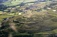
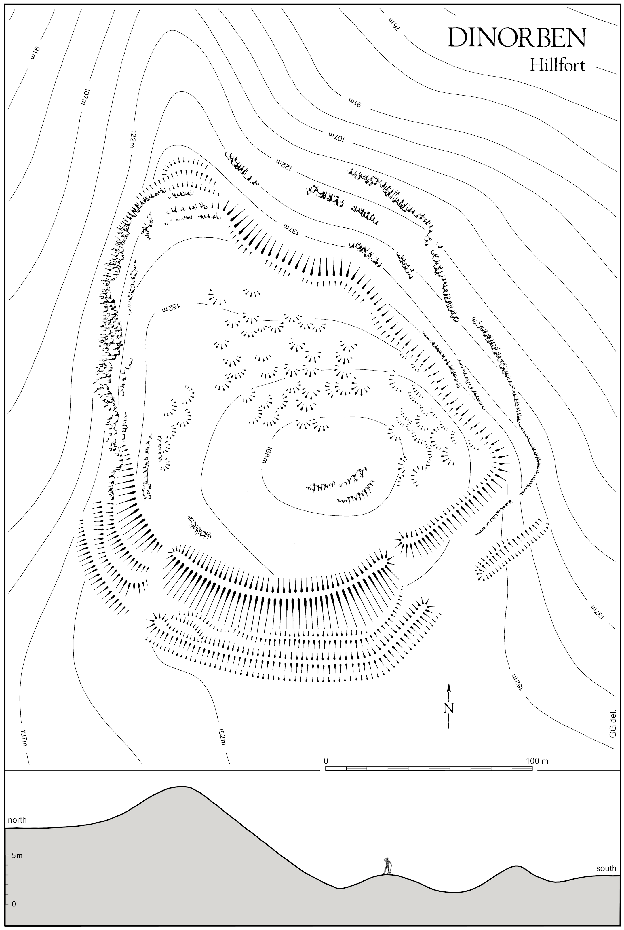
Obliterated through quarrying during the 20th century, this limestone headland formerly towered over the wide coastal plain some 150m below. Among hillforts strewn across north Wales, the extraordinary size of Dinorben's 'main' earthwork made it one of the most striking (described, while the hilltop was intact, in Gardner and Savory 1964, 11-12, as depicted in a plan first published by Gardner in 1913). The massive innermost bank, doubtless degraded to a degree, rose a full 7m above the buried land surface in its central sector and almost 12m above the floor of its external ditch where it crossed the vulnerable, c.200m wide southern neck of the promontory (Figure L). This puts it on a par with the mighty Maiden Castle in Dorset, a prodigious feat, whatever its age and composition.
Outer lines of bank and ditch will have enhanced both the strength and the grandeur of this fort to anyone taking the easy approach from the south, irrespective of whether the imposing ensemble of earthworks was designed to confront would-be assailants, impress neighbouring rivals, or intimidate awe-struck subordinates. Along the west, precipitous crags required no artificial strengthening, whereas the north tip and the east side, with crags more broken, were topped by a single, relatively slight, earthwork. Thus defined, the rounded hilltop afforded rather more than 2ha of usable space, with at least 60 platforms recessed into its more steeply-sloping parts (Figure L ― platforms first recorded by Savory [1959, 20, fig. 1], admitting that 'only the more definite examples have been plotted', and it is likely that dense undergrowth will have exacerbated other difficulties of recognition). As seen inside many other prehistoric hillforts, the platforms are frequently assumed to have served as emplacements for buildings (as by Savory) and so, simplistically, implying a densely-inhabited settlement.
Repeated investigations in the 20th century provided a wealth of information, albeit leaving many questions unresolved. The first known excavations came in 1912-22, directed by Willoughby Gardner, followed by campaigns in 1956-61 and 1965-9, at the hands of Hubert Savory, each exploring the site selectively in pursuit of research goals as then perceived. The fullest account of Gardner's findings was brought to publication by Savory in 1964, in tandem with that of his own initial fieldwork, and supplemented with wide-ranging discussion. In structural terms, a highlight of that volume is its description of the South-East Entrance (Gardner and Savory 1964, 17-29), revealed by progressive excavation to have begun as a relatively plain stone-lined gate-passage, eventually supplanted by one equipped with a pair of 'guard-chambers' located directly behind the gate (see section 2.5 and note 18). The similarity of this broad sequence to that of an entrance excavated half a century later (by J.L. Davies) at the hillfort on Moel Hiraddug, barely 10km east of Dinorben across the Vale of Clwyd, is instructive, emphasizing the lasting value of this aspect of Gardner's protracted endeavours (Guilbert 1979b). Nevertheless, this should not distract us from realizing that much else presented in the 1964 report must be negotiated with vigilance (cf. section 2.1 ― criticisms probably equally valid of much other digging of that era, not only concerning hillforts), as illustrated here by the cautionary tale of an iron axe once purported to demonstrate the date of some part of Dinorben's defences (see section 2.2).
The most dramatic outcome of Savory's second phase of fieldwork at Dinorben was promptly and widely disseminated (1971a, 1971b, 1971c), announcing several radiocarbon dates that led him to postulate a fort first built 'startlingly early' ― 'during the 9th or early 8th century BC' ― and defended across the neck of the promontory by a rampart revetted and laced ('staged') in timber. He was emboldened to declare this 'a Bronze Age hillfort'. It is necessary to appreciate that the dates cited in 1971 were 'raw' (i.e. uncalibrated BP, but beware because mainly stated as BC), though Savory soon grappled vaguely with 'recent refinements of radiocarbon dating', which he felt gave licence to affirm his stance more forcefully, seeming to allow a century of backdating ― 'probably in the 10th or 9th century' ― and inducing a rash assertion that the earliest rampart was not merely constructed but even 'destroyed before the end of the Late Bronze Age' (1976a, 244-6). Meantime, Savory was taken to task by some over both structure and dating (especially Alcock 1972b; cf. Bradley 1975, 156; Guilbert 1977a, 44), while others were less questioning, apparently content merely to receive his claims, thereby prolonging the illusion of a well-understood and very early rampart (e.g. Burgess 1974, 197, 207; Challis and Harding 1975, 105; Hogg 1975a, 29-30, 47, 190; and, curiously, for some it has continued thus even until quite recently (e.g. Brown 2009, 67; Darvill 2010, 239, despite his own 1987, 128; Mullin 2012, 82)). In essence, the problems arose from lax interpretation, including suspect treatment of the radiocarbon dates, without serious allowance for old-wood constraints implicit in sampling 'mature oak' (Savory 1971a, 10-11, 76-8 ― ironic, as he acknowledged risks inherent in using 'building material rather than … freshly gathered wood'), and with scant regard for complexities of archaeological context. Besides that, the chosen method of excavation ― Savory's 'crowning work' of 1969, essentially machining collapsed infill from one of Gardner's narrow trenches in the south-western sector in order to cut back a standing section for recording and sampling (1971a, 7-8, figs 7-9, pls V and VI) ― left much to be desired, for it could offer little prospect of an accurate portrayal of the form of successive ramparts, especially those at greatest depth within the composite bank, still less therefore of any meaningful, rather than misleading, dating of a sequence of development (cf. section 2.3).
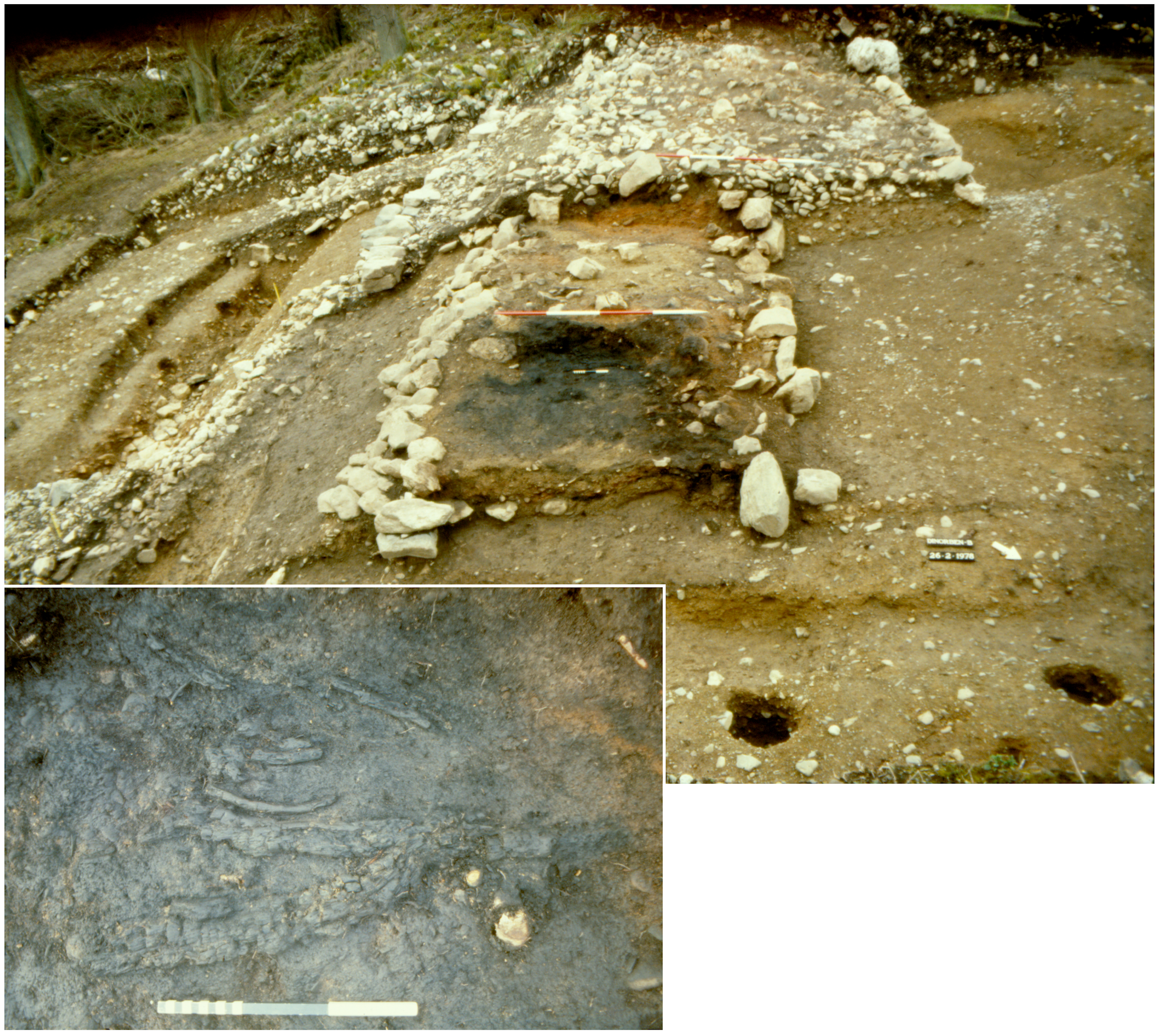
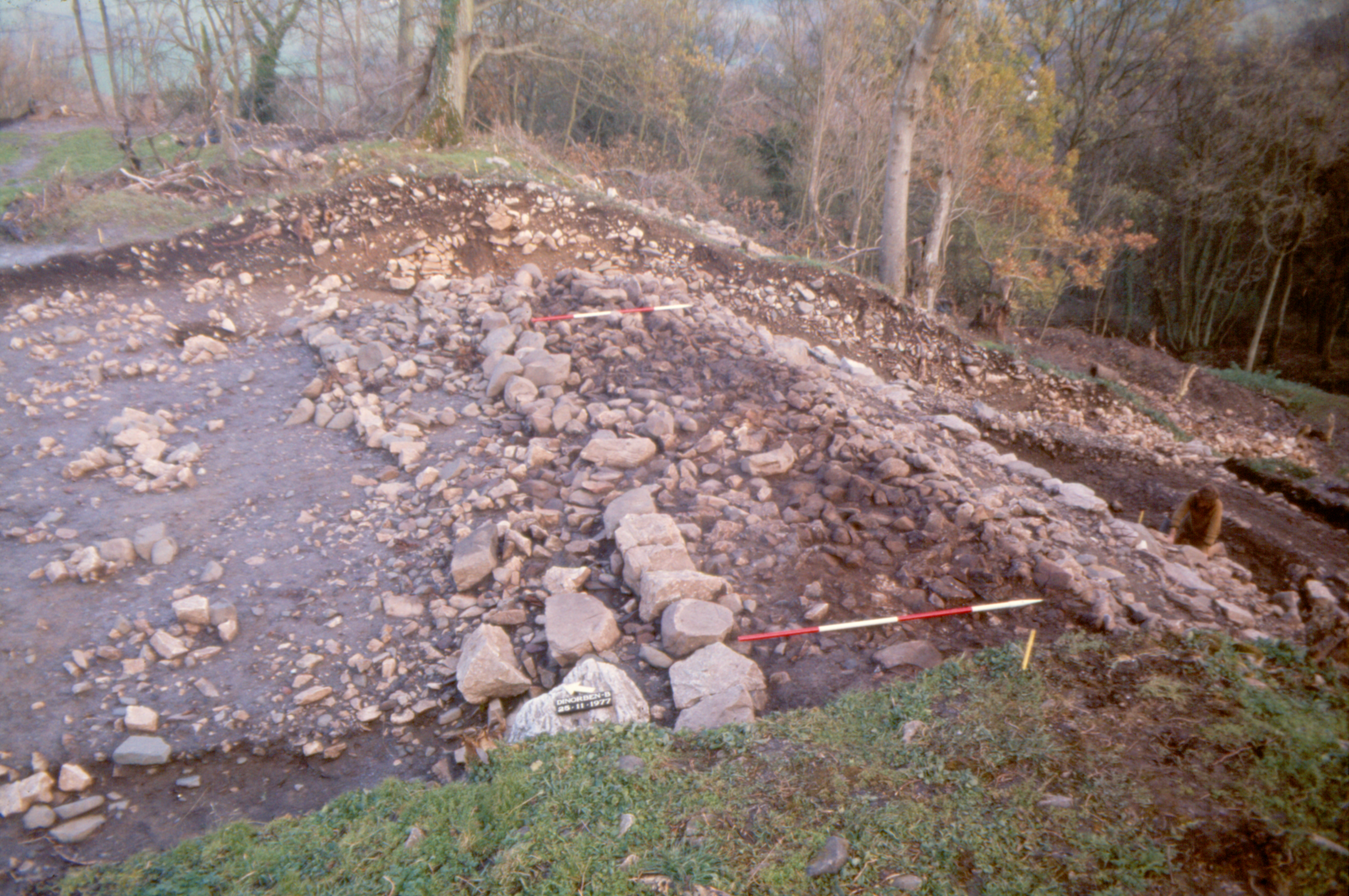
Notwithstanding the objections voiced, Savory's pronouncements loomed large in the literature, because the concept of Late Bronze Age hillforts had become an elusive 'grail' for numerous prehistorians in Britain, and it was scepticism over the frailties of the case at Dinorben that inspired the final excavations there (conducted by Guilbert in 1977-8). By then, only one stretch of the earthworks remained fit for the purpose of seeking to settle outstanding questions of chronology before all chance of doing so would be lost to the quarry, and this lay near the south-east corner of the hillfort (between Gardner's trenches WG10 and 11, as numbered in Savory 1971a, fig. 2). As luck would have it, materials suited to solving the biggest issue were retrievable, viz. charred branches sealed within the core of the early rampart, which was itself shown to have incorporated a timber-frame set in postholes as well as being encased in stone revetments (Figure M; Guilbert 1979a, 184-6). These young, single-entity samples, closely associated and securely stratified, supplied a dependable group of four radiocarbon dates, indicating construction in the period 550-400 cal BC (i.e. mean of CAR-119 to CAR-122 at 83% probability [740-400 cal BC at 95%] — cf. Guilbert 1979c; 1980). This dating evidence has far greater integrity than that generated by Savory, surely justifying attribution of the early rampart to the Iron Age, and most probably to its second quarter, which is about as accurate as can reasonably be expected for this portion of prehistory (in light of a marked flattening in the line of calibration — the 'Hallstatt plateau' — effectively reducing precision across the first half of the Iron Age to no better than a couple of centuries ― see Hamilton et al. 2015).
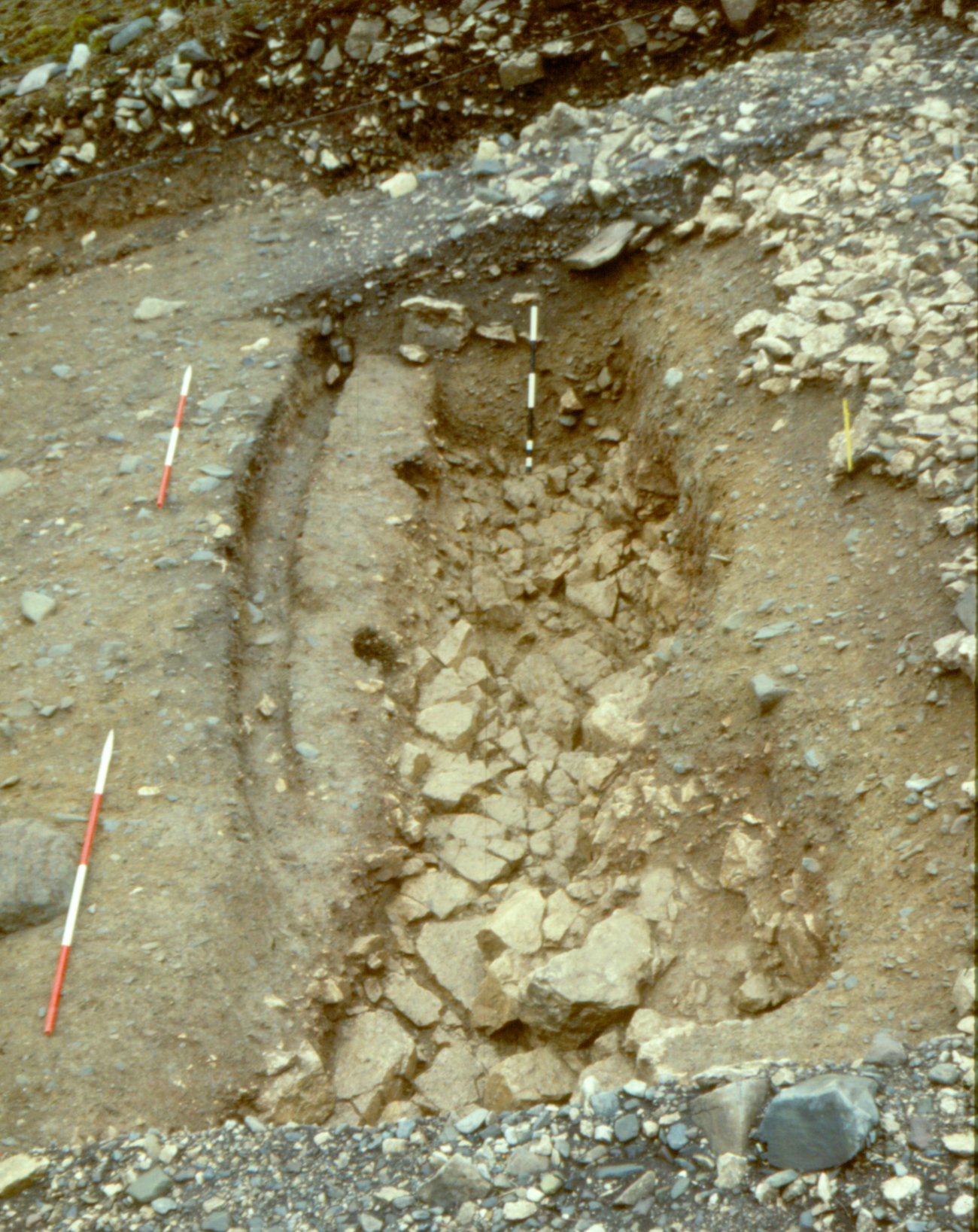
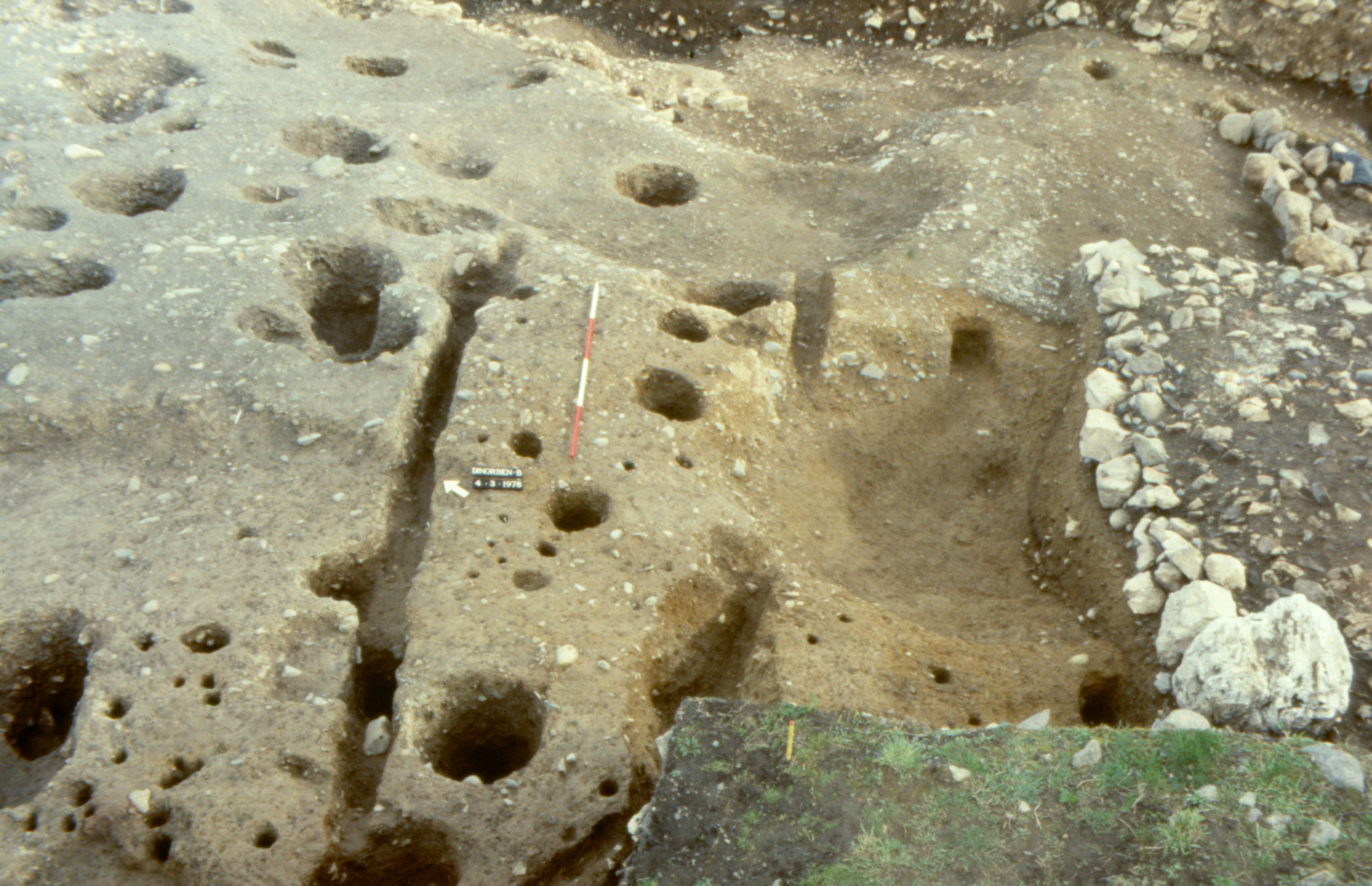
It is true that an earlier ditch (Figure N) seems likely to have been accompanied by a parallel bank of upcast, perhaps even formed into a small rampart, though nothing of this survived where excavated in 1978. Animal bones recovered from that ditch are dated 795-430 cal BC (CAR-128, at 95% probability), indistinguishable from the measurements cited above for the earliest recorded rampart. What is more, there is every possibility that the dated rampart was preceded by several, maybe all, of five lines of palisade, each represented by a foundation-slot embodying a freestanding fence (Figures N and P); and one of these was cut through the fill of the early ditch (Guilbert 1979a, 183-6). At the very least, then, it is reasonable to infer that the sequence of hilltop-enclosure was both complex and lengthy, but not necessarily continuous, presumably starting with one or other of the palisades, the remainder being raised thereafter in succession or in various combinations. Fragments of similar slot, all buried beneath the multi-phase inner bank, seem to have been glimpsed by Gardner or Savory at locations c.80-130m west of the area examined in 1978 (cf. note 11), encouraging a deduction that more than one of the palisades will have been positioned so as to secure the entire c.2ha of the promontory from the plateau to its south, apparently protecting ground of comparable extent to that later bounded by the ramparts of the hillfort. If so, this might be taken to suggest that the palisade(s) presaged the purpose of the rampart(s), be it as consecutive symbols of strength or as a long-lived practical stronghold. That said, cause to question any assumption of a wholly defensive function (i.e. the width of an entrance) has emerged from wider investigation of a yet more extensive palisaded enclosure at Moel y Gaer, Rhosesmor (c.25km distant from Dinorben), there contouring the hilltop as precursor to another hillfort.
Frustratingly, the Moel y Gaer palisade is also without independent dating, but, intuitively, we may feel tempted to surmise broad contemporaneity with some stage of that traversing the Dinorben promontory. All told, it is undeniable that, at each site, these palisades could signify an extension of the period of enclosure, arguably defence of a sort, back beyond the Iron Age, though we can never now be sure of an origin at Dinorben before c.800 BC, which translates as a reasonable approximation for the end of the 'Late Bronze Age' in recent chronologies (e.g. Cunliffe 2005, 31-2; Needham 2007, 39-42 ― and note that the former remains more sanguine over assigning hillforts to the Late Bronze Age, in central southern England anyhow (Cunliffe 2006, 153, 155-6, 159), than does the latter, who feels they should no longer be considered a 'key feature' of this period (Needham 2007, 55), with The Breiddin seemingly exceptional (Musson et al. 1991)). Incidentally, such imprecision is bound to make it quite unprovable whether or not a palisade already safeguarded the top of the Dinorben promontory when the celebrated Parc y Meirch (or Abergele) hoard of bronze horse-gear was deposited at the foot of its western crag, possibly in association with human remains, and probably in c.9th century BC (Hughes 1872; Savory 1976b, 17, 44-5, 52-3, fig. 9).
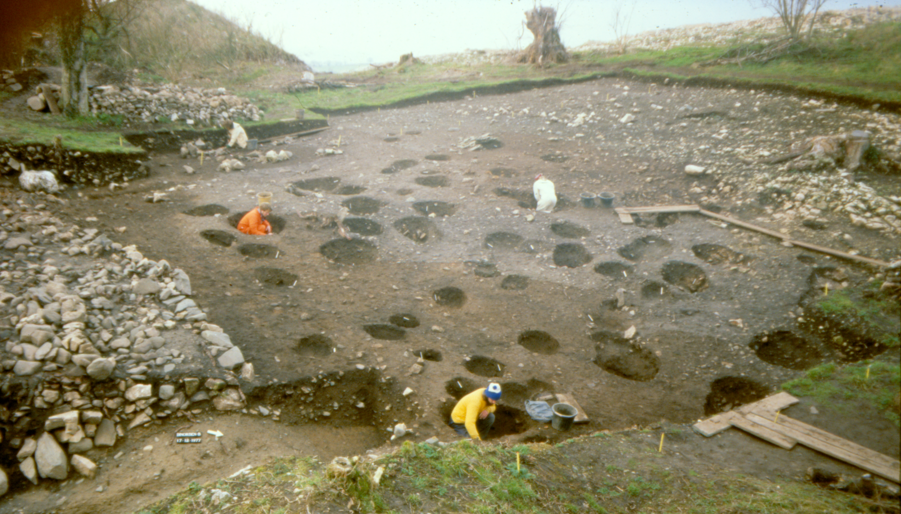
There is, or was, more to Dinorben than the 'spice of controversy' over its original 'fortification', and certain other aspects command briefer attention here. In the south-east sector, later developments included at least one enlargement of the rampart, again revetted with stone at front and back, and apparently furnished with banquettes, or revetted tiers, along its inner slope (Figure Q; Guilbert 1979a, 184-6). There were probably extra episodes of bank-building in the bigger, central stretch, as well as the addition, at some stage, of the outer banks and ditches. There are indications that enlargement could have occurred while the rampart of the c.6th-5th centuries cal BC was not much dilapidated, and this may have been when the guard-chambered gateway was introduced. Inside the hillfort, a series of factors ― the character of the bedrock, the duration of occupation, and the piecemeal nature of the excavations ― have conspired to create uncertainties. A small, perhaps circular, stake-built structure was detectable solely because its platform was cut into clayey till, which overlay the limestone at that point, in contrast to much of the hilltop ('platform 39' in Guilbert 1979a, 188; cf. Moel y Gaer). Some thickness of soil infilled that platform, along with a wider area in the lee of the rampart, before a mass of postholes was dug into it (Figure R), the best-defined structures at that level belonging to a linear layout of four-post buildings, of unknown function but attributable to a Romano-British reoccupation (Guilbert 1979a, 187-8; cf. Moel y Gaer in the Iron Age; and note that a four-poster excavated in 2008, around 800m south of those within Dinorben hillfort, is said to have produced 'significant quantities of burnt grain' (Wood 2009, 60)). There is no other reliable evidence for specific structural forms of any period at Dinorben (a possible post-ring roundhouse on 'platform 35' offering the best bet ― Guilbert 1979a, 182, with plan on 183). Despite popular and sweeping, indeed facile, use of terms like 'hut-floor' or 'house-platform', excavation has made it questionable whether some, maybe many, of the recessed platforms mapped in Figure L were truly formed to accommodate any type of building, let alone a dwelling (Guilbert 1981a, 114-16, fig. 22).
The finale of Dinorben's life as a fortified hilltop is as nebulous as its beginning. This is a rare example of a hillfort yielding snippets of evidence — notably two iron arrowheads — for possible military action by 1st-century Romans (Davies 1977); but some refurbishment of the earthworks late in Romano-British and/or early in post-Roman centuries has been mooted repeatedly and inconclusively, leaving it debatable whether Dinorben was among a diverse group of defended, some think 'high status', settlements scattered around Wales in immediately post-Roman times (Guilbert 1979a, 186; Edwards and Lane 1988; Seaman 2016). What does seem assured is that affluence was focused upon the old hillfort for some time during the first half of the first millennium AD. Savory was consistent in believing that Dinorben had become the 'headquarters of an agricultural estate', a native 'nobleman's residence' (Gardner and Savory 1964, 70, 96-9; Savory 1976a, 287; 1989, 161), manifested principally by abundant Roman-period artefacts, attesting wealth and industry, plus a sizeable coin-list of the 3rd-4th centuries AD. He may be correct, but substantial structures postulated for that period and 'into the 5th century' — allegedly 'large circular houses' and an 'aisled house' — are not easily sustained on the evidence put forward amid lengthy deliberation (Gardner and Savory 1964, 66-72, 103-7, fig. 14; Savory 1971a, 18-19, 30-1, fig. 7; cf. Alcock 1965; 1972b; Davies 2000, 88). A very few artefacts hint at activities of some kind continuing, or resuming, here beyond the 4th century, seemingly corroborated by the youngest of the radiocarbon dates obtained late in the 1970s. Falling largely within the 5th-7th centuries cal AD (at 95% probability, from CAR-203 = 1600±65 BP, CAR-204 = 1550±50 BP, and CAR-130 = 1475±55 BP; Guilbert 1979c; 1980, 338), these all came from animal bones found in the outer ditch of the hillfort, c.40m from the nearest part of its precinct and so seeming suggestive of settlement outside the enclosed promontory, in an area which has also now succumbed to quarrying, this time without close investigation. At some point, the local centre of medieval authority is reputed to have migrated to a less-exposed location on the plateau, almost 1km south from the hillfort (in the vicinity of the present Dinorben farm, SH968748) — and this is another side of Dinorben to have attracted its share of contention (e.g. Alcock and Jones 1962; Gardner and Savory 1964, 98).
Internet Archaeology is an open access journal based in the Department of Archaeology, University of York. Except where otherwise noted, content from this work may be used under the terms of the Creative Commons Attribution 3.0 (CC BY) Unported licence, which permits unrestricted use, distribution, and reproduction in any medium, provided that attribution to the author(s), the title of the work, the Internet Archaeology journal and the relevant URL/DOI are given.
Terms and Conditions | Legal Statements | Privacy Policy | Cookies Policy | Citing Internet Archaeology
Internet Archaeology content is preserved for the long term with the Archaeology Data Service. Help sustain and support open access publication by donating to our Open Access Archaeology Fund.