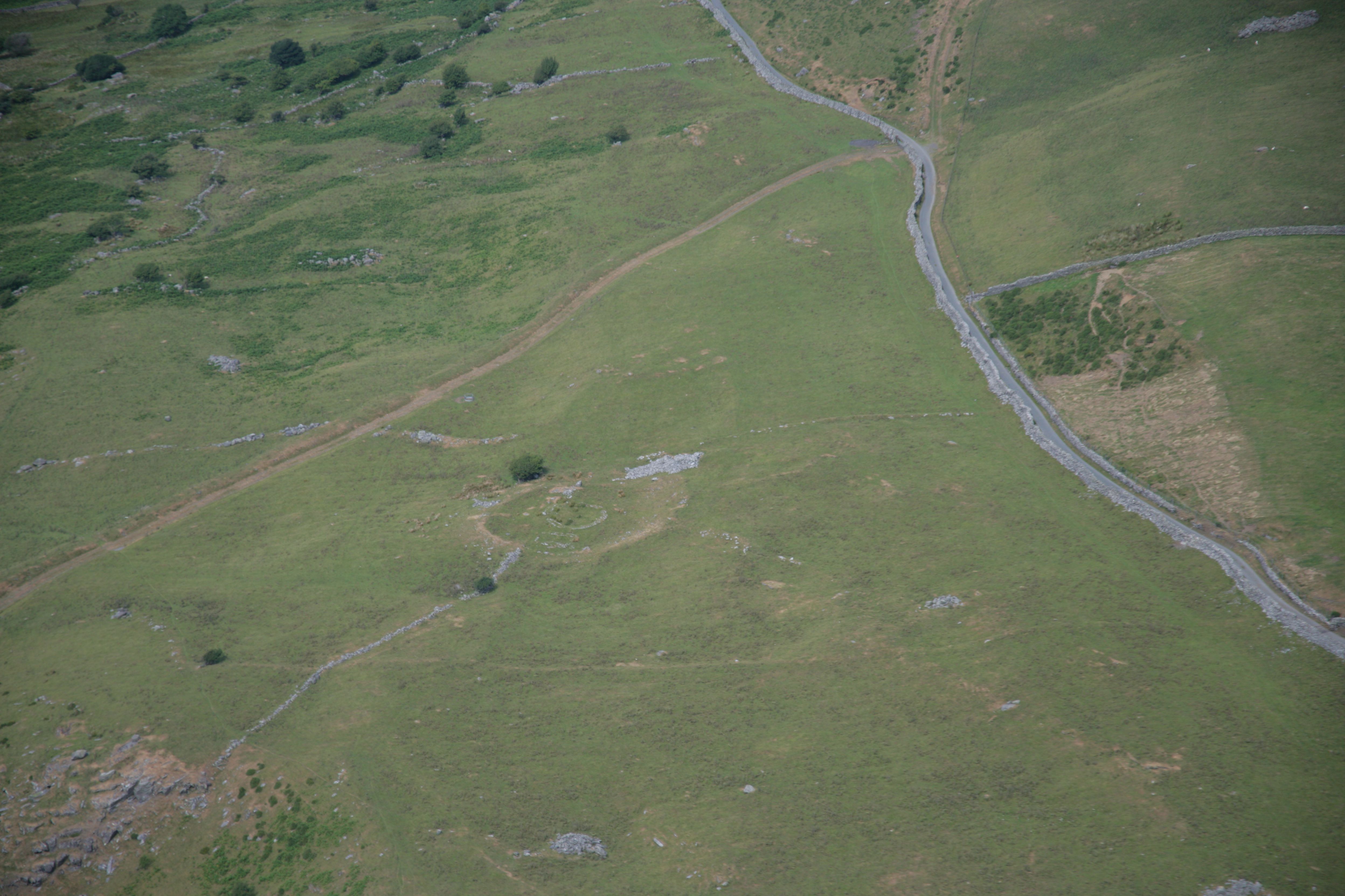
The environmental setting of Erw-wen (Figure A) and Moel y Gerddi, two late prehistoric enclosures in upland Ardudwy, was investigated by analysis of pollen from a nearby valley mire and from old ground surfaces at the sites (Chambers et al. 1988, Chambers and Price 1988). Radiocarbon dates suggest that Erw-wen was older than Moel y Gerddi, perhaps by c. three centuries. Moel y Gerddi was at a slightly higher altitude than Erw-wen but both were within possible cultivation limits. Substantial deforestation had already occurred in the area prior to the building of the enclosures, although woodland was still available. Timber was used for construction at both sites and minor falls in arboreal pollen probably reflects the impact of these sites on the local tree cover. A change from timber roundhouses to smaller stone-built houses suggests a dwindling timber supply.
Higher amounts of heathland pollen in samples from Moel y Gerddi than Erw-wen suggest a deterioration in soil conditions over time (although this process might have commenced much earlier) and that this was of increasing importance at a higher altitude. Cereal type pollen and charred cereal remains confirm that arable cultivation was taking place in the area and charred weed seeds suggest that some cultivation was taking place on acidic soils. The evidence for cereal cultivation is, however, scarce and it is likely that these enclosures were essentially pastoral settlements with limited cultivation. Archaeological evidence suggests that cultivation occurred at lower altitudes, probably at Erw-wen (Chambers and Price 1988; Kelly 1988), with an emphasis on pastoral farming at higher altitudes. A more equable climate and population pressures might have influenced the establishment of Moel y Gerddi at a slightly higher altitude. Climatic and/or soil deterioration probably led to abandonment of the site and possibly some recovery of woodland in the area, before renewed clearance in Roman times.
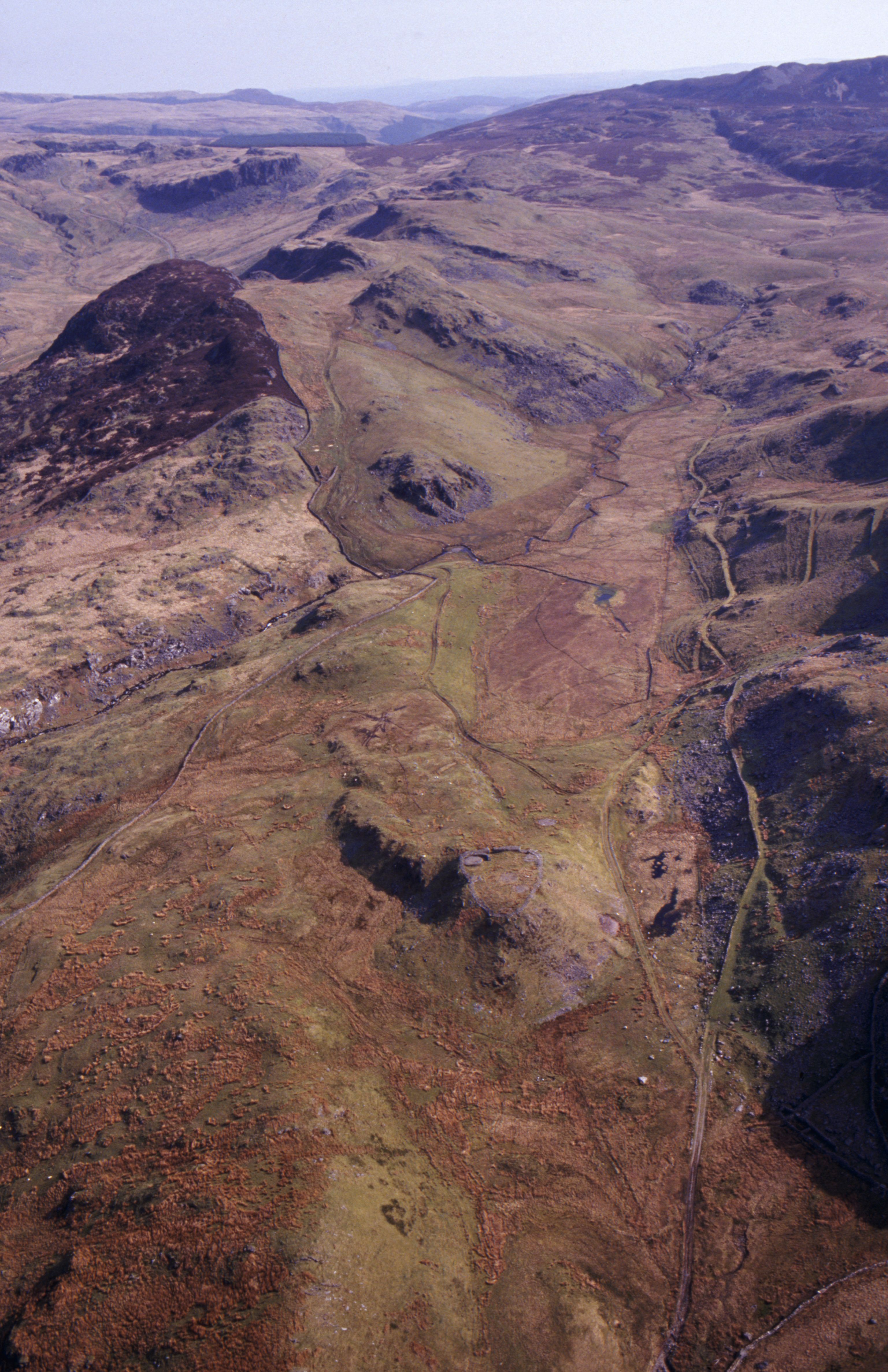
A pollen study involving multiple pollen sites was undertaken at Bryn y Castell (Figure B) hillfort (Mighall and Chambers 1995; Mighall and Chambers 1997) to determine the possible impact of ironworking on the surrounding landscape. The results indicate a dramatic decline in woodland had already occurred in the area during the Late Bronze Age but pockets of deciduous woodland still survived at the time of occupation. Woodland was already decreasing immediately prior to the commencement of ironworking. This might represent the use of wood for buildings within the fort or the fort's defences, as well as clearance for agriculture. Two phases of ironworking activity were identified, one in the late Iron Age and one in the Romano-British period. The greatest impact on woodland occurred nearest to the hillfort, although only limited woodland clearance occurred during the ironworking period. It has been estimated that around 2.5 ha of mature sessile oak or 5 ha of alder would have been required to produce the estimated 156kg of iron at the site. However, if ironworking took place over a period of around 220 years, as estimated, then the amount of wood required each year would have been relatively small. Changes in the pollen curves for oak, alder, birch and hazel indicated their exploitation, but evidence of woodland management could not be identified. Macroscopic charcoal from the site confirmed the use of these species. During the Romano-British period construction of the Sarn Helen Roman road and agricultural activity may also have contributed to the decline in woodland in the area.
Recent investigations at Tregaron South-East Bog (Lomas–Clarke and Barber 2007; Figure C) have included geochemical analysis (silicon and titanium) as well as pollen analysis to determine changes in land use in the area. They particularly illustrate changes during the Late Iron Age/Roman period, demonstrating increased agricultural activity prior to the arrival of the Romans in the area, although it was further enhanced at that time.
The pollen evidence indicates that the surrounding area was dominated by scrubby woodland in the mid- to late Iron Age. Previously an extensive period of woodland clearance was dated to 400 cal BC and c. the 3rd century BC. The recent work suggests a phase of substantial hazel scrub clearance c. 100 cal BC, accompanied by increased evidence for mixed farming. A second phase of increased agricultural activity is dated to about cal AD 75 to cal AD 375, and is possibly related to establishment of the Roman fort of Bremia, nearby. Peaks in silicon and titanium suggest increased soil erosion as a result of farming activity and woodland clearance. From around cal AD 375 arable and pastoral farming indicators decline and some woodland/scrub regeneration occurs, reflecting a reduction in human activity in the area.
Internet Archaeology is an open access journal based in the Department of Archaeology, University of York. Except where otherwise noted, content from this work may be used under the terms of the Creative Commons Attribution 3.0 (CC BY) Unported licence, which permits unrestricted use, distribution, and reproduction in any medium, provided that attribution to the author(s), the title of the work, the Internet Archaeology journal and the relevant URL/DOI are given.
Terms and Conditions | Legal Statements | Privacy Policy | Cookies Policy | Citing Internet Archaeology
Internet Archaeology content is preserved for the long term with the Archaeology Data Service. Help sustain and support open access publication by donating to our Open Access Archaeology Fund.