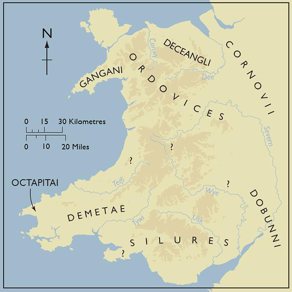
The Roman geographer Ptolemy left us with a generalised but valuable description of the native tribes of Wales. For the first time in the prehistory of Wales we have names for some of the people in the landscape (Figure C). While many authors and academics have offered differing views on precise division of territory, it is generally agreed that Wales was occupied by five or six main tribes at the time of the Roman conquest (see detailed discussion in Burnham and Davies 2010, 19-22); the Demetae in the south-west (approximating Pembrokeshire and Carmarthenshire), the Silures in the south and east (approximately modern Glamorgan and parts of Brecknock to the Wye), the Ordovices in the mid- and north-west of Wales (broadly Anglesey, Gwynedd and much of Powys, and the Deceangli in the north-east (modern Denbighshire and the Clwydian range). The Cornovii occupied the fringe of north-east Wales, the Borderlands and the Cheshire and Shropshire Plains. Cunliffe (1991) shows the Dobunni occupying south-east Wales east of the Usk, together with parts of Avon and Somerset. A recent interpretation of the name Demetae by Andrew Breeze (2005) suggests it means 'the supreme cutters-down', alluding to a proficiency with swords and the ostentatious use of weaponry.
Although these descriptions are a vivid record of the peoples who united in the face of the Roman threat, under native 'kings' and 'queens' like Caratacus and Cartimandua, such general tribal names can be misleading when trying to understand the true complexity of Iron Age Wales. The real territorial landscape was no doubt far more complex, based on smaller regions or even distinct topographic localities perhaps only tens of kilometres across. The Roman record of just two minor tribal names along the west coast, documented during sea passages, is instructive in this respect. Ptolemy noted the Gangani occupying the Llŷn Peninsula, a restricted geographic unit with fairly distinctive stone-built hillforts, and the Octapitai, on St. David's Head, Pembrokeshire, again a distinctive promontory dominated by a substantial fort (Clawdd y Milwyr), outer defences and field systems. The existence of numerous small groups would reflect far more realistically what is already suggested by the archaeological record; that Iron Age Wales was a land of small regions linked by common architecture and settlement patterns but also displaying marked local distinctiveness — a rich but well-connected mosaic of distinct peoples occupying blocks of landscape a few tens of kilometres in extent (see Gwilt 2003, 112). Key Welsh hillforts, like Foel Drygarn in Pembrokeshire, Penycloddiau in Clwyd, Pen-y-crug near Brecon or Caerau at Ely, Cardiff, are worthy contenders for 'tribal capitals' in this dense cultural mosaic of Iron Age Wales, built by peoples and leaders whose names are now lost. Similar themes were explored by Sellwood (1984) in her investigation of 'sub-tribal' boundaries in the Wessex/Upper Thames area based on a study of numismatic evidence (Sellwood 1984, fig. 13.11). The extent of our remaining ignorance as to the real complexity of this cultural mosaic is indicated by the question marks on this new version of the tribal map of Wales (Figure C).
Internet Archaeology is an open access journal based in the Department of Archaeology, University of York. Except where otherwise noted, content from this work may be used under the terms of the Creative Commons Attribution 3.0 (CC BY) Unported licence, which permits unrestricted use, distribution, and reproduction in any medium, provided that attribution to the author(s), the title of the work, the Internet Archaeology journal and the relevant URL/DOI are given.
Terms and Conditions | Legal Statements | Privacy Policy | Cookies Policy | Citing Internet Archaeology
Internet Archaeology content is preserved for the long term with the Archaeology Data Service. Help sustain and support open access publication by donating to our Open Access Archaeology Fund.