This is the Key Identification Number (the Key-Id), always ten characters in length. Every context on site was issued with a unique number comprised of the site number (e.g. 002) followed by the area code (e.g. DD) followed by the context number (e.g. 00034). These three elements combine to form a unique Key-Id of a feature. It enables the context to be located in any database, matrix or plan and is the vital link between them. A Master Number is a number issued to a structure or group of contexts closely related, intended to tie together individual contexts into a coherent whole. Where a master number was issued, it will always appear as the title of the document. Where there is no master, the cut number of the feature will always be used.
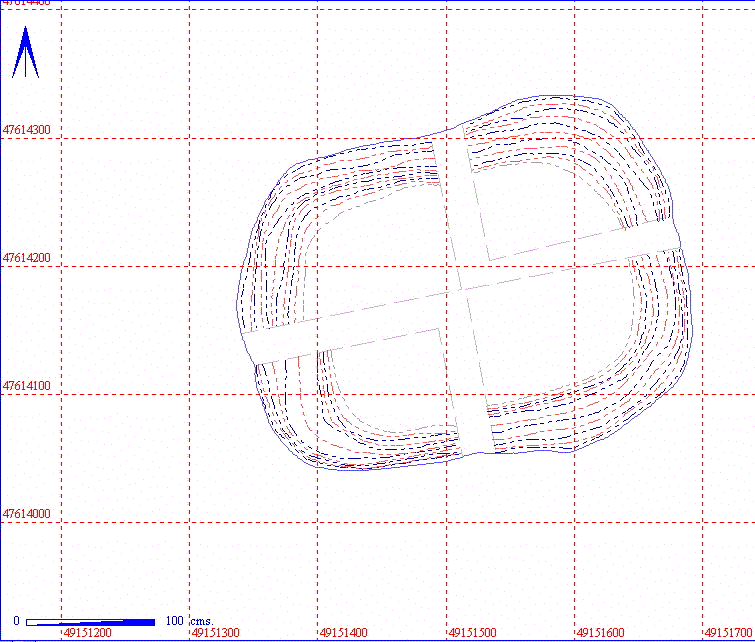
The clickable map shows a small part of the digitised site plan. The clickable map is generated so that the features or structure which represents the master context is centrally positioned. A scale bar is always in the bottom left hand corner of the plan. North is always to the top of the page, as indicated by the north arrow in the top left hand corner of the plan. The full OS grid co-ordinates appear on the bottom (easting) and the left (northing) of the plan.
Any other feature that appears on the plan will have a hyper-link to take you to the relevant document. If you click on a button and nothing happens, or a query comes up to say the document has not been found, then that document has not yet been created.
| Grubenhaus Details | |||||||
| Length | 350 | Width | 254 | Depth | 60 | Ratio | 1.37:1 |
| Area | 8.23 sq. metres | Volume | |||||
| Number of Posts | 0 | ||||||
| Highest Elevation Value | 5328 | ||||||
| Lowest Elevation Value | 5268 | ||||||
| Bearing | 78 degrees | ||||||
| Structural Class | |||||||
| Material Culture | Number of Objects | 27 | Number of Animal Bones | 109 | |||
| Environmental | |||||||
Where applicable, a summary of structural details is included, so that the structure's vital statistics can be viewed without having to read any more of the document. The table of details for different types of feature reflect the nature of the feature, so that only the table for a burial would indicate the burial position of the skeleton, i.e. flexed. Where there is no table, most of the necessary statistics can be found in the master or cut context notes or in the discussion element of the document. Most of the statistics should be self-explanatory, but a few need further comment.
Length, Width and Depth are all maximum statistics, unless stated otherwise, and are always in centimetres. The dimensions are measured in G-Sys from the digitised plans.
Ratio is the length divided by the width.
Area is the area of the of the structure, always in square metres.
Volume has been included although an accurate method of calculating it has not yet been established, and will be expressed in cubic metres.
Elevation is obtained from a 3-dimensionally recorded point taken during excavation. The lowest elevation value of the Grubenhaus will be the highest elevation minus the depth of the cavity. In the post hole structure table, the highest elevation will be the highest post hole fill, the lowest will be the deepest post hole cut.
Bearing is measured in G-Sys and is the alignment of the structure, starting from 0 degrees at due north and working clockwise to 359 degrees. When measuring the alignment of a burial, a line from the base of the spine through the skull is used..
The difficulty in phasing sites of the Anglo-Saxon period is such that the phasing is very much a product of the analysis rather than a precursor to it. As the analysis proceeds this section will be updated with alternative views of the phasing based both upon the pure stratigraphic sequence and upon the specialist analysis of the material culture. In either case, the degree of certainty needs to be articulated since real precision is unlikely in data sets from the Early Anglo-Saxon period.
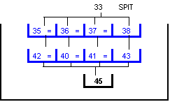
This example based upon a single fairly simple structure does not demonstrate stratigraphic links to other features above and below. In daily use the stratigraphic matrix displayed on the page is designed to support hyper-links that allow one to browse the site stratigraphically.
Much of the phasing has yet to be completed, more detail will be added to this part of the document as analysis progresses and specialist reports are received.
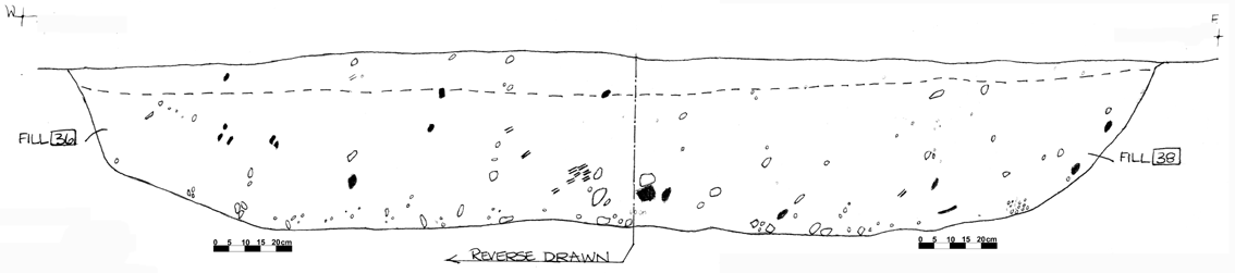
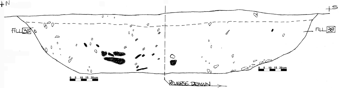
A steep-sided, sub-rectangular Grubenhaus in the north of Area 2DD. The structure is situated to the west of a trackway, of unknown date. No post-holes were discernible during excavation. Each quadrant was excavated using a different context number, though in fact only two fills, a primary and a secondary, were present. The two fills were distinctive, the upper, secondary fill containing a much higher proportion of blown sand (Munsell colour 10/YR/46) than the lower, primary fill (10/YR/43).
The feature or structure can be discussed in any detail with any relevant information. This field will be added to as analysis proceeds.
A steep sided, sub-rectangular Grubenhaus in the north of area 2DD. The structure is to the west of a trackway, of unknown date. No post holes were discernible during excavation.
| MASTER | CUT | FILLS | VOLUME | OBJECTS | AN BONE | DENSITY |
| 002DD00034 | 4 | 21 | ||||
| 002DD00045 | 002DD00035 | 1 | 12 |
Where a master number was issued, that number will always appear in the top left hand side of the table, otherwise there will be a short description of the context. The objects associated with a context are hyper-linked to the Object Totals by Material tables, or, in the case of few finds (i.e. less than 5), straight to the Objects by Context table. Similarly, the animal bone in the table is hyper-linked to the Animal Bone Totals by Species tables or the Animal Bone by Context.
The aim of the totals tables is to provide a quick resumé of the finds in a given context without having to go through the entire list of objects or animal bones. Totals tables only appear in documents where there were a large number of finds. Each context has its own table and each one of these tables is hyper-linked to the main Objects by Context or Animal Bone by Context tables further down in the document.
| 002DD00034 | Fired Clay | 1 | |
| Pottery | 1 | Early Saxon | |
| Stone | 1 | ||
| Unfired Clay | 1 |
| 002DD00035 | Slag | 1 |
| 002DD00034 | Cattle | 16 |
| Goat | 1 | |
| Sheep | 1 | |
| Sheep/goat | 3 |
| 002DD00035 | Cattle | 8 |
| Goat | 1 | |
| Sheep/goat | 3 |
An abridgment of the context database. Usually, every cut number and its associated fills will have its own context table. Anomalies in the context record are due to the primacy of the data.
| KEY_ID | TYPE | SHAPE | L | B | D | PROFILE | NOTES |
| 002DD00035 | GRUB FILL | TRIANGULAR | 155 | 105 | 24 | FLAT | PRIMARY FILL OF M34:SW QUADRANT;WINDBLOWN SAND. FEW FINDS THESE KEPT BY CONTEXT ONLY. QUITE DISTINCT FROM LOWER FILL. |
| 002DD00045 | GRUB CUT | SUB-RECTANGULAR | 347 | 267 | 60 | WIDE U | CUT OF GRUB M34 IN NW 2DD. VREY STEEP SIDED WITH SL CONCAVE/FLATTISH BASE. NO P.H.s LOCATED. CUTS A NATURAL OF SAND. SMALL BUT VERY DEEP. |
A reduced field abstract from the objects database.
OB or OBJ - The object number in the database to allow the individual object to be traced in the full objects database.
No - The number of objects/fragments under the object number.
[animal bone table]
A reduced field set from the animal bone database.
QUANT - the quantity of bone recovered
CHEW - evidence of chew marks
BURNT - signs of burning
BUTCH - signs of butchery
FBRK - fresh breaks
© Internet Archaeology
URL: http://intarch.ac.uk/journal/issue5/westhescd/example1.htm
Last updated: Mon Oct 5 1998