The decision to attempt a 3D model of the Aberdeen Carmelite Friary derived from several factors. Aberdeen City Council Archaeological Unit, which had been responsible for the excavation and post-excavation work at the site, had a long history of providing two dimensional artists' impressions as part of the normal process of reporting the results of excavations to the public. The fact that the Unit lay within a Museum setting, with responsibilities for making excavated evidence as accessible as possible and the presence within the team of professional illustrators, made that kind of presentation particularly desirable. The move to 3D resulted from the coincidence of an excavation where it was felt that sufficient multi-disciplinary evidence was available with the presence initially within The Robert Gordon University and latterly within the company PinkZeppelin of enthusiastic and skilled specialists who were eager to undertake the work.
It should be noted that the post-excavation and publication process at this site has been extremely lengthy. At the time when the 3D visualisation was created (2002), it was notably groundbreaking in its quality and execution. Below is a description of the project development, written by Jan Dunbar, the illustrator who worked closely with the visualisation team.
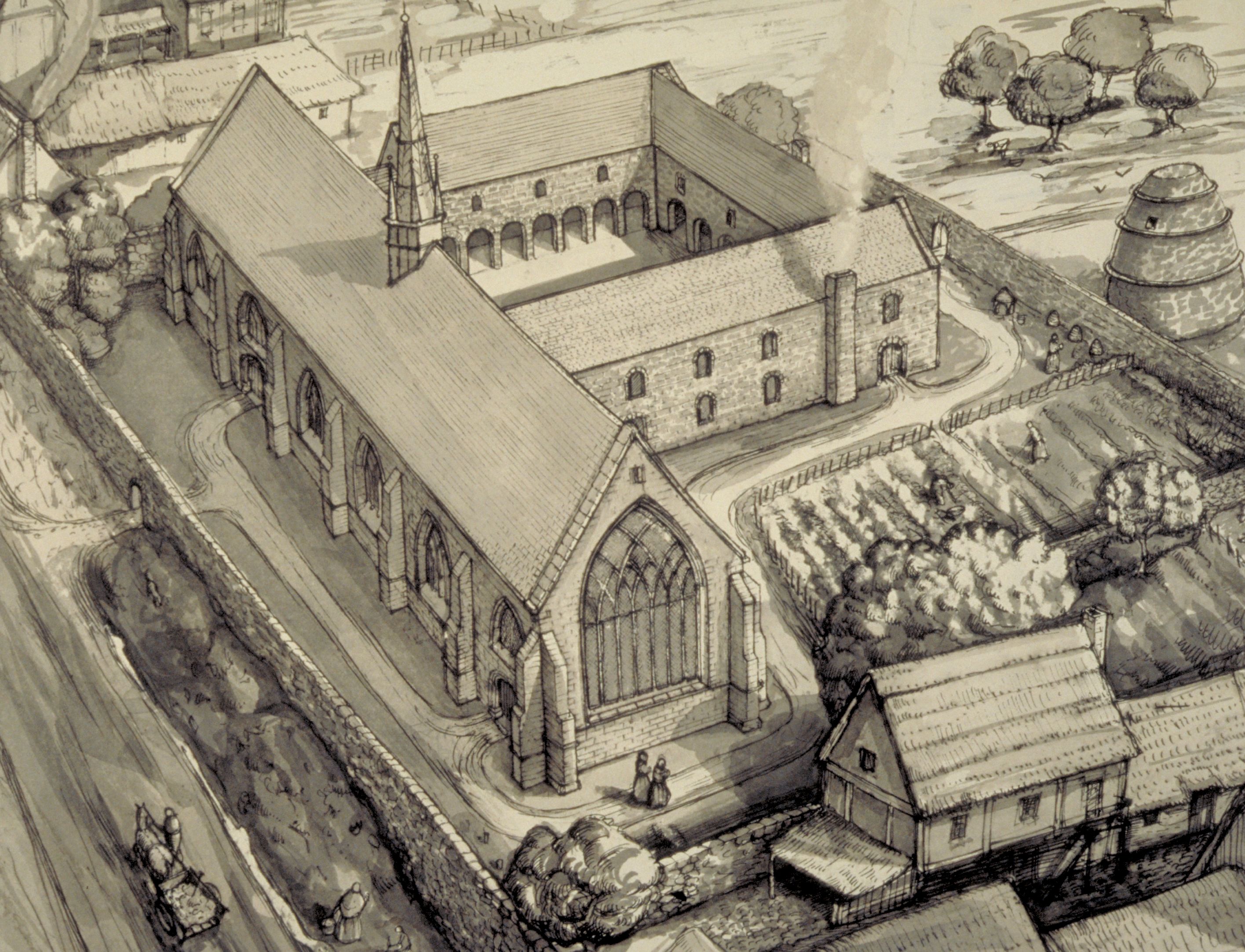
The process of developing a three-dimensional model of the Carmelite Friary began with the production of a plausible reconstruction of the friary complex set within the historic area of the Green. Several reconstruction drawings were made in order to 'set the scene' for PinkZeppelin, who had been contracted to produce the animation, along with countless images of windows, doorways, floor tiles, roof slates, wall paintings and suchlike.
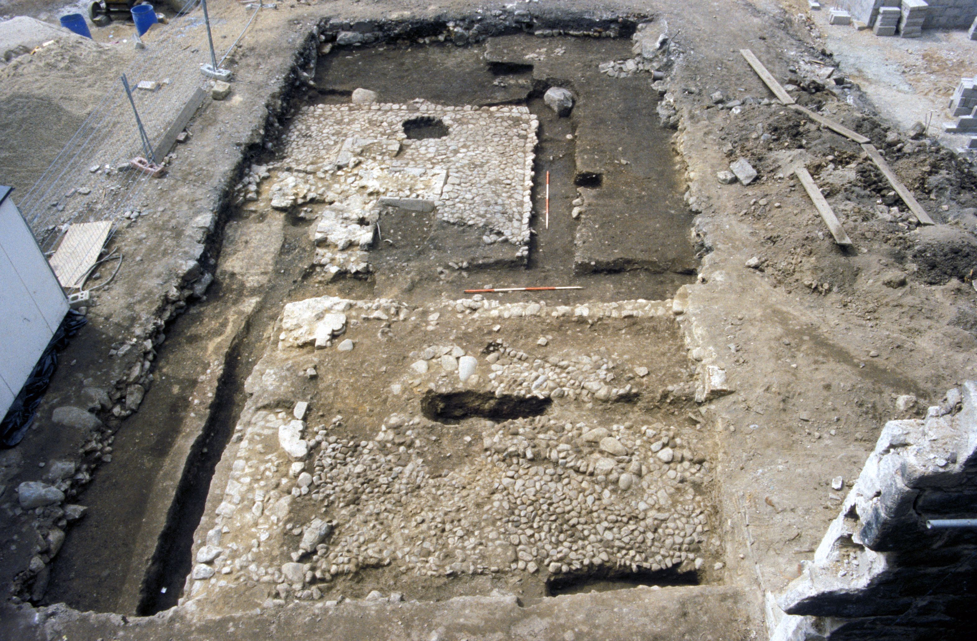
The reconstruction was based on the excavated remains, which comprised the area around the west end of the church and part of the west range. Some smaller trenches were opened to the east of the main excavation, revealing small portions of walls which were taken into account when estimating the size and layout of the complex. At all stages, draft illustrations were sent to specialists to verify and to offer advice when needed.
Scottish medieval friaries were laid out to a standardised ground plan, around a cloister which was ideally square in shape and situated to the south of the church, although variations occurred where space was limited by natural features or by the built environment (pers. comm. J. Patrick Greene, 1992). The east range characteristically comprised the sacristy, chapter house, warming room and the dormitory and latrines, whereas the south range held the refectory and main kitchens. The storage rooms and cellars supplying the kitchens were adjoining in the west range, along with accommodation for the Prior and the lay brothers, although this was sometimes located in separate buildings. Other related buildings are likely to have included an infirmary, guest house, bake house, brew house and an assortment of other buildings associated with the daily life of the friary.
It proved fairly easy to come up with a plausible layout for the church, the west and east ranges, but the south range was more problematic as a small L-shaped wall at the S-W corner of the complex did not line up with the main buildings in the west range. The problem became obvious when the first attempts were made to convert the ground plan into a three-dimensional reconstruction. It became clear, for example, that all the buildings could not be of the same height as it was impossible to tie in all the roof structures.
A hearth, discovered in the west range, had been interpreted as a kitchen although it was very small (c 5x3m) — indeed too small to serve the number of friars and lay brothers, possibly as many as 40 at the time of the Friary's peak around 1450, when the model was to be 'set'. (Copsey 1995) It is suggested that this small kitchen served only the Prior's house and that a larger kitchen was attached to the refectory, which would conform to the classic friary layout.
A wall, excavated to the east of the church, was interpreted as the outer wall of the church. Burials to the east of this wall where therefore considered to be in an outside graveyard rather than burials within the church. Although there is no archaeological evidence of a central tower, there are several references to bells having been rung, and it was decided that a simple bellcote was the more likely option. Walls and a cobbled area to the north of the church suggested a courtyard with possibly a gatehouse as an entrance to the complex, and an area of garden soil to the west implied use as kitchen gardens conveniently positioned for the Prior's kitchen.
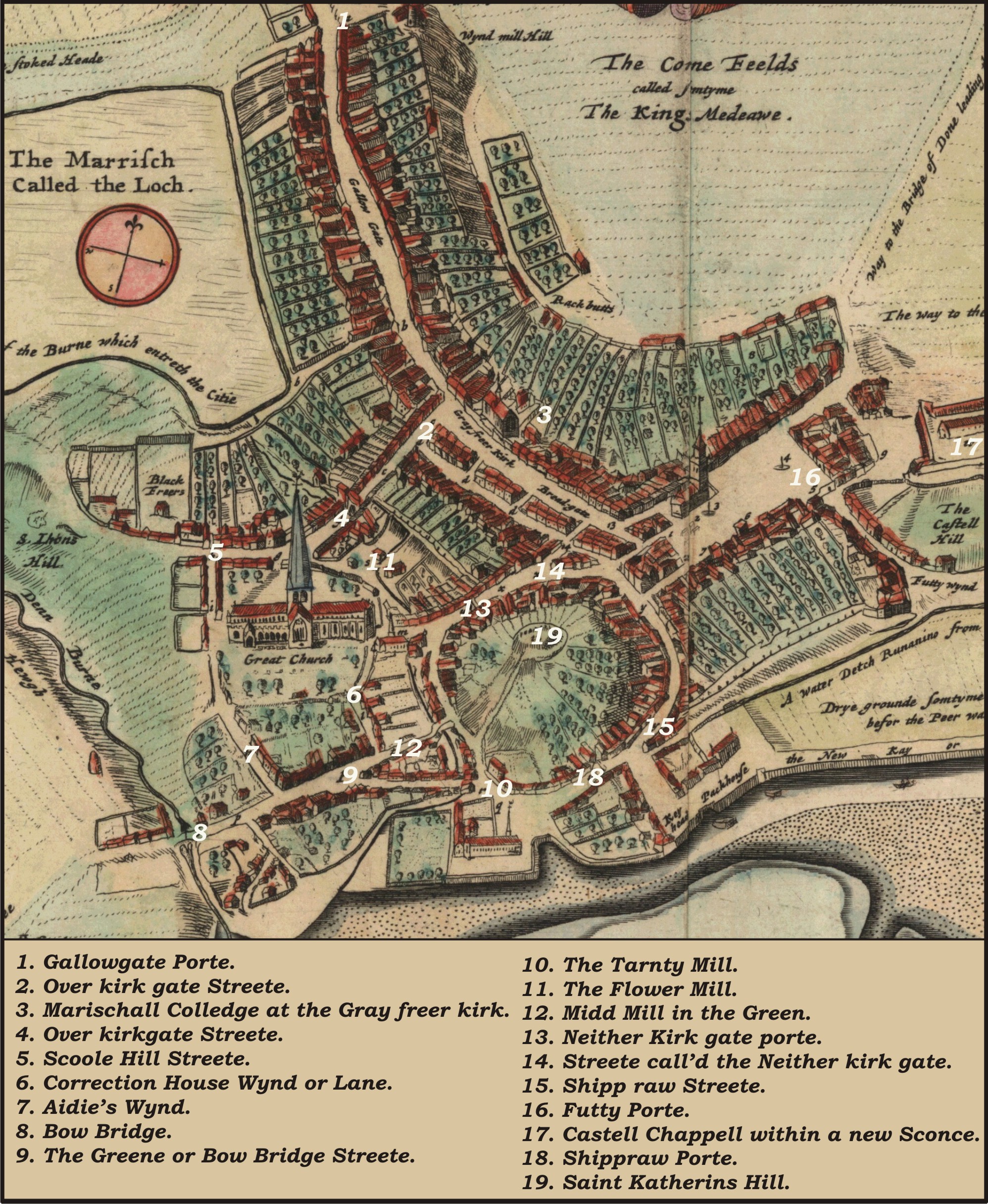
It was decided that the model should concentrate on the areas where there was some definite, excavated evidence, and also to attempt to set the friary within the Green and surrounding area, showing the topography of central Aberdeen before the construction of Union Street destroyed the medieval town plan. The earliest map showing the Green is Parson Gordon's map drawn in 1661 (Figure 8), after the friary had been demolished; the only reference from Gordon being to 'the friar's kilns', situated to the S-W of the site. This and various subsequent maps were scanned and overlaid onto the computer plan, intensive research began into land ownership and use during the 15th century and this, along with some assumptions of continued use of land boundaries and thoroughfares, made it possible to arrive at a workable boundary for the friary complex. Once a satisfactory ground plan had been agreed upon, it was possible to work out a rough 'story board' for the animation to follow.
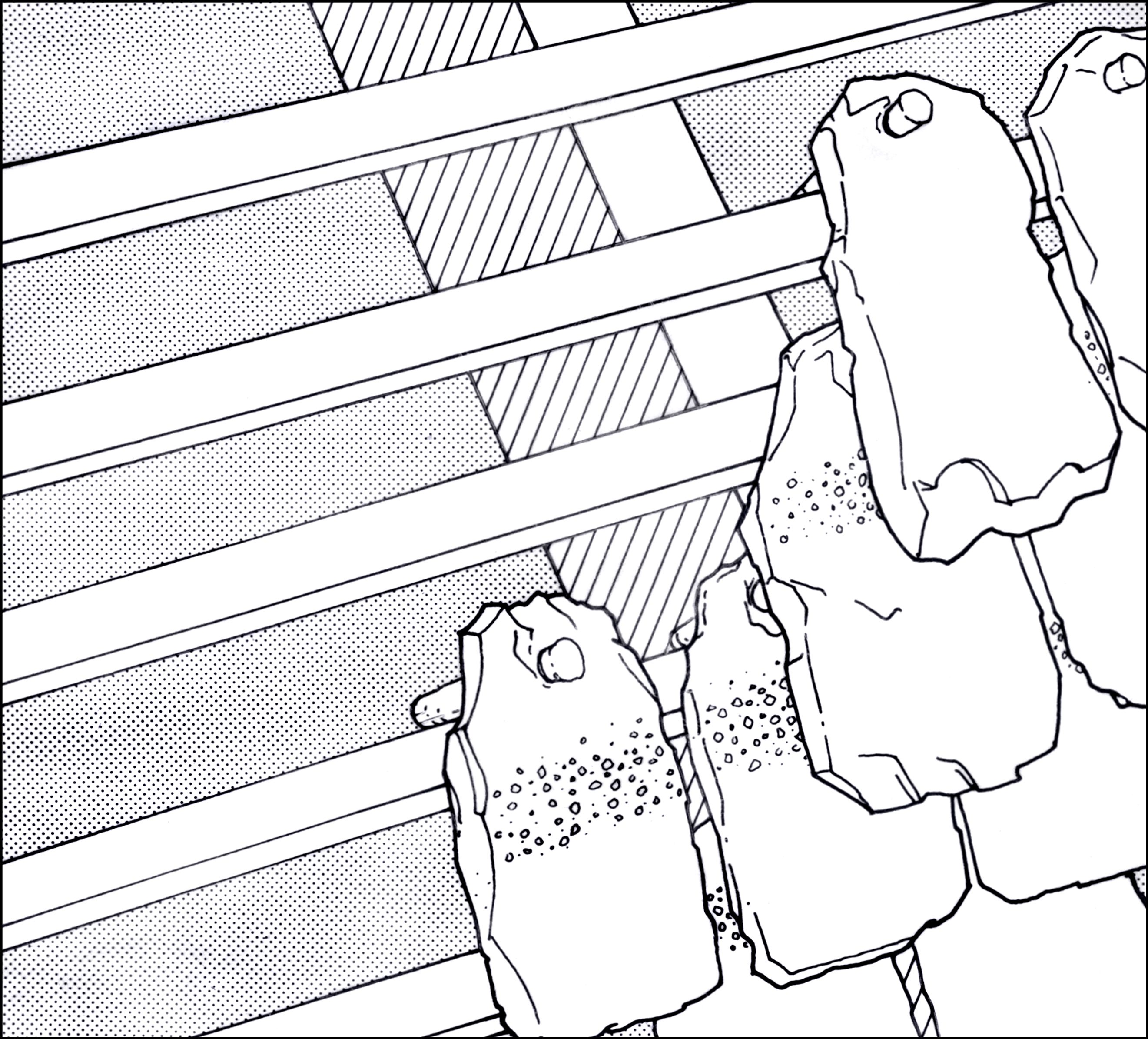
The 'fly-through' takes the viewer over Aberdeen in 1450, travelling east along the Green and down a vennel, which leads to the gatehouse of the friary. Each view was carefully drawn in pencil before being converted into a digital format by PinkZeppelin. Having come through the gatehouse, the viewer find themself in a small cobbled area, before entering the actual church through the elaborate doorway. Because two moulded blocks [4, 5] from the doorway had been excavated and drawn, it was important to show this doorway in detail and therefore much effort went into working out exactly how the mouldings and threshold would have looked.
Once inside the church, the viewer sees a grave being prepared in the nave before travelling up the church to glimpse, through the rood screen, the altar where the body is lying in preparation for burial. Floor tiles and window glass were found during the excavations and these were incorporated into the reconstruction. In the case of the glass, it was possible to work out where the decorated windows had been situated as the positions of the individual sherds of decorated, coloured and plain glass had been planned. From documentary evidence, we know that the church contained statues of the Virgin Mary and St Anne and altars to the Blessed Virgin, St Anne and the Holy Cross. There would also have been the features common to all friary churches of the time, such as the rood screen and choir stalls. The walls of the choir have been shown as being decorated, whereas the nave is seen as being much plainer. All the features depicted have been based on examples from the correct date and, if possible, from the north-east of Scotland.
On leaving the church, the fly-through moves into an area of very fine cobbling, which had been meticulously planned during the excavation. This was scanned and used in the model to try and give the effect of the cobbles and rain channels.
Travelling down the side of the west range and through the kitchen gardens, the viewer comes to the Prior's kitchen. The archaeological evidence for the kitchen is a large cobbled hearth set against, but not into, the south wall and a roughly rectangular area of cobbles against the east wall, for which there was no obvious use. The fact that there was a large open fire suggested that there was only one storey to this room. Smoke must have escaped through the roof and it was decided that there must have been some sort of suspended structure (an early 'hanging lum' ) guiding the smoke out through a hole in the roof which was capped with a chimney pot. The sub-rectangular area of cobbles was interpreted as a storage platform. Pots and barrels on view are based on excavated examples.
Once the animation leaves the kitchen, the reconstruction becomes more speculative. We know that the friary had a church, cloister, refectory, dormitory, infirmary and kitchen (Copsey 1995) and we can assume that the infirmary would have been separate from the main complex. There must have been a main drain, serving the reredorter and the infirmary, and we can assume that it ran through the friary grounds and out into the burn which ran along the eastern boundary.
It should be mentioned that the reconstructions were as accurate as possible at the time that they were drawn. Producing the model was a very long process and it is true to say that further research has meant that some small details would have been shown differently. This is the nature of historical research and interpretation.
Internet Archaeology is an open access journal based in the Department of Archaeology, University of York. Except where otherwise noted, content from this work may be used under the terms of the Creative Commons Attribution 3.0 (CC BY) Unported licence, which permits unrestricted use, distribution, and reproduction in any medium, provided that attribution to the author(s), the title of the work, the Internet Archaeology journal and the relevant URL/DOI are given.
Terms and Conditions | Legal Statements | Privacy Policy | Cookies Policy | Citing Internet Archaeology
Internet Archaeology content is preserved for the long term with the Archaeology Data Service. Help sustain and support open access publication by donating to our Open Access Archaeology Fund.