Cite this as: Loy, M.P.A, Stocker, S.R. and Davis, J.L. 2021 From Archive to GIS: Recovering Spatial Information for Tholos IV at the Palace of Nestor from the Notebooks of Lord William Taylour, Internet Archaeology 56. https://doi.org/10.11141/ia.56.5
This article is a case study in doing new things with old data. In 1953 Lord William Taylour directed the excavation of a monumental vaulted tholos tomb known as 'Tholos IV' at the site of ancient Pylos, Messenia, Greece. The excavation was conducted over two months, during which detailed notes were recorded in three notebooks now kept in the Archives of the American School of Classical Studies at Athens. The formal publication of Tholos IV, however, contains only a basic narrative of the excavation, offering neither precise detail on stratigraphy, object find spots, nor even a complete inventory of small finds. The present study goes back to the original notebooks kept by Taylour and combines the data contained in them with a new digital survey of Tholos IV to produce a comprehensive and accurate 3D GIS model for the excavation. Furthermore, the GIS has been produced in such a way that its dataset is compatible with new excavation data currently generated in the ongoing Palace of Nestor Excavations (PONEX) project, bringing together two excavation campaigns conducted under very different circumstances, methodologies, and recording protocols. Discussion follows on how the production of this GIS deepens our understanding not just of the legacy excavation, but also of the site and its wider landscape.
Corresponding author: Michael P.A. Loy
m.loy@bsa.ac.uk
British School at Athens
Sharon R. Stocker
stockesr@ucmail.uc.edu
Department of Classics
University of Cincinnati
Jack L. Davis
davijk@ucmail.uc.edu
Department of Classics
University of Cincinnati
All images and data are used with permission from the Palace of Nestor Excavations, Department of Classics, University of Cincinnati
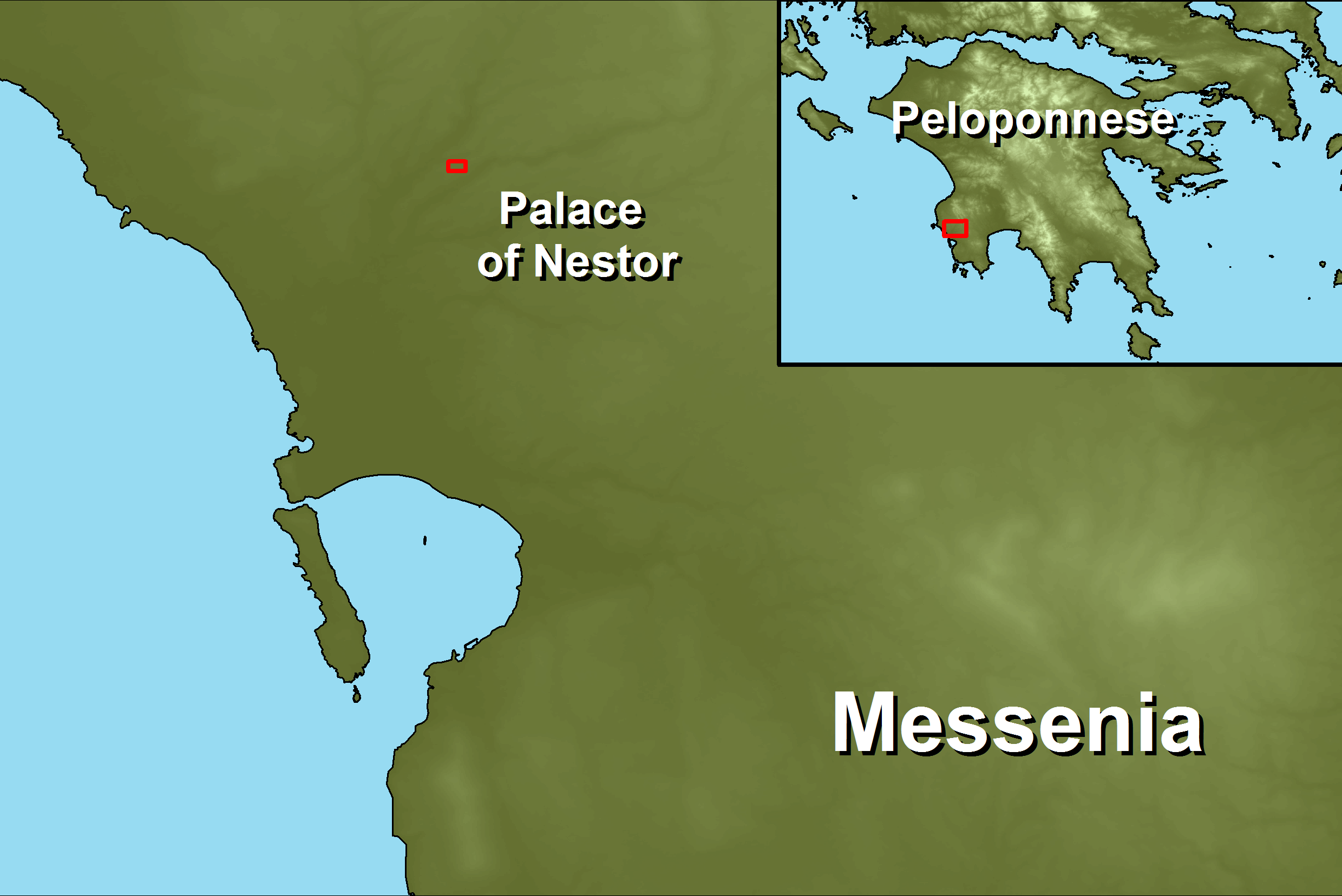
Figure 1: Location of Palace of Nestor, Messenia, in the Peloponnese of Greece (Figure 1b). Excavated architectural remains from the Palace, Griffin Warrior Grave and the two new Tholos tombs (known as Tholos VI and Tholos VII) are reproduced here in order to put Tholos IV into its wider site-level context.
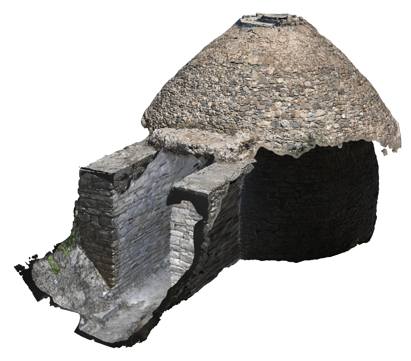
Figure 2: Oblique view of Tholos IV, Palace of Nestor. This photogrammetry model is synthesised from four separate models (chamber, antas, lintel stone, and domed roof exterior) and is georectified using both GPS-referenced control points and locally-referenced common anchor points.
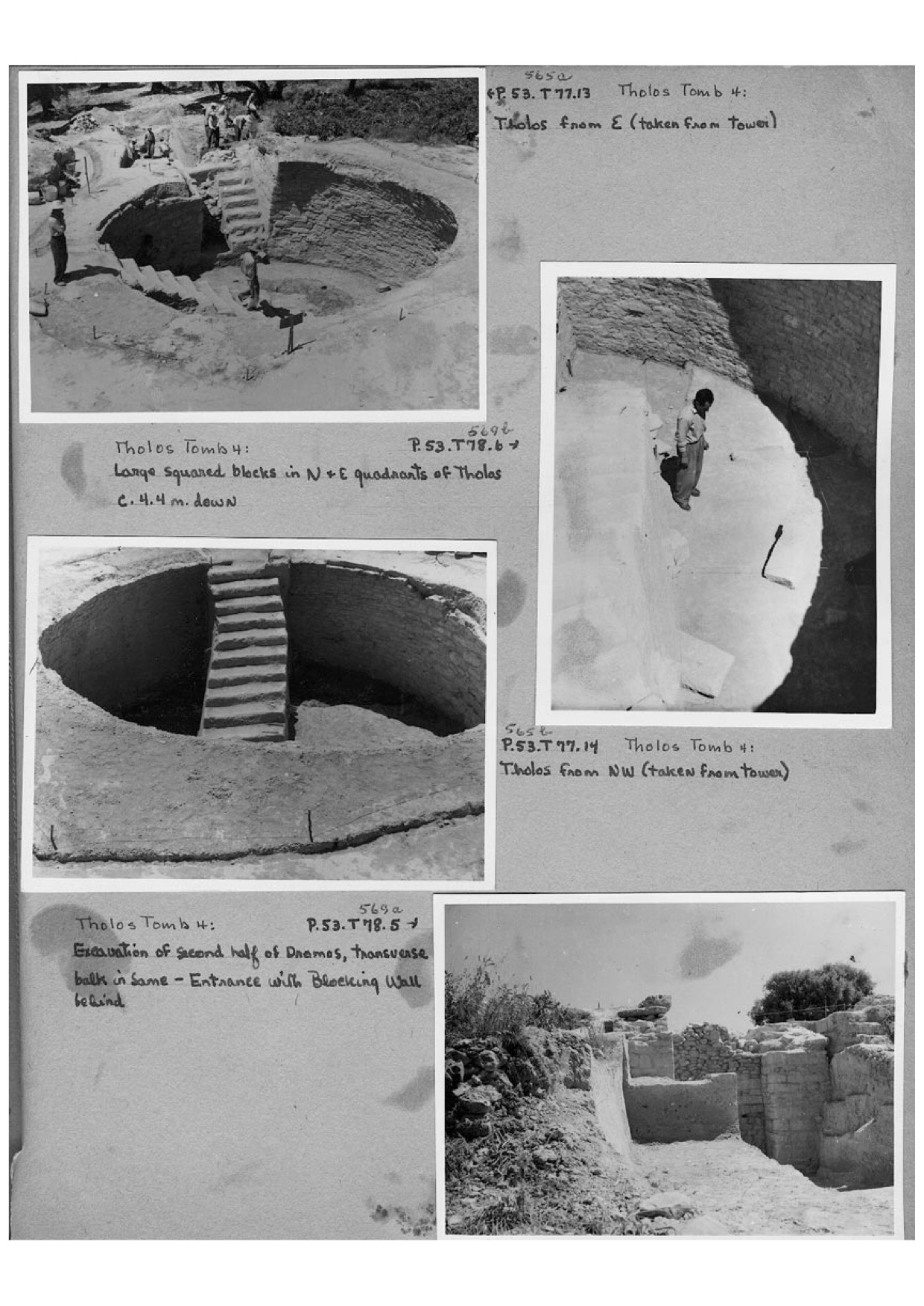
Figure 3: Photographs of the excavation of Tholos IV, from ASCSA Archives, Pylos Excavations Archive, Box 8, 'Pylos 1952-1953'. From the top, the first and third photographs illustrate the construction of an artificial staircase used by the excavators to access the tomb's chamber. The second photograph shows the division of the chamber into two sectors, and the bottom photograph shows the clearing of the dromos in front of the stomion.
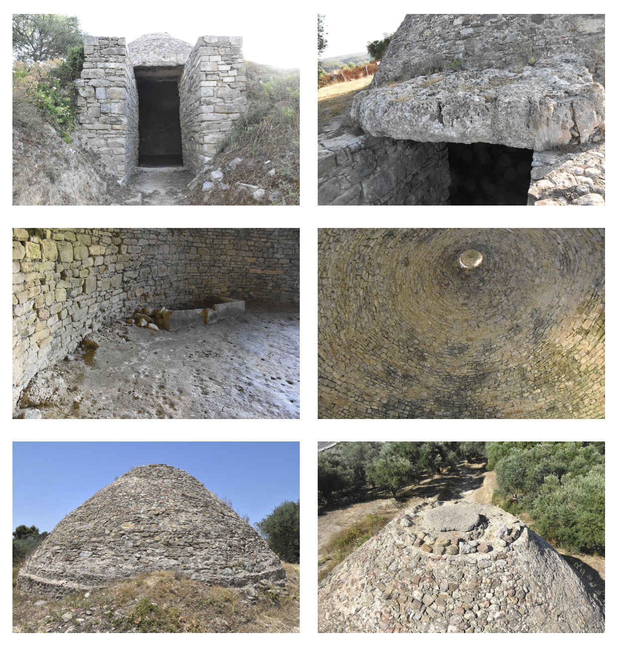
Figure 4: Photographs taken during the production of the photogrammetric model that illustrate the current state of the Tholos IV reconstruction. From left-to-right, the first two images show the stomion and lintel block of the tomb, indicating also that the tomb is built into the side of the hill. The third and fourth images show the inside of the tomb, and respectively illustrate the walled cist grave and the modern reconstructed capstone on the domed roof. The fifth and sixth pictures show the state of the domed roof from the exterior, the sixth picture also showing the extent of the dromos.
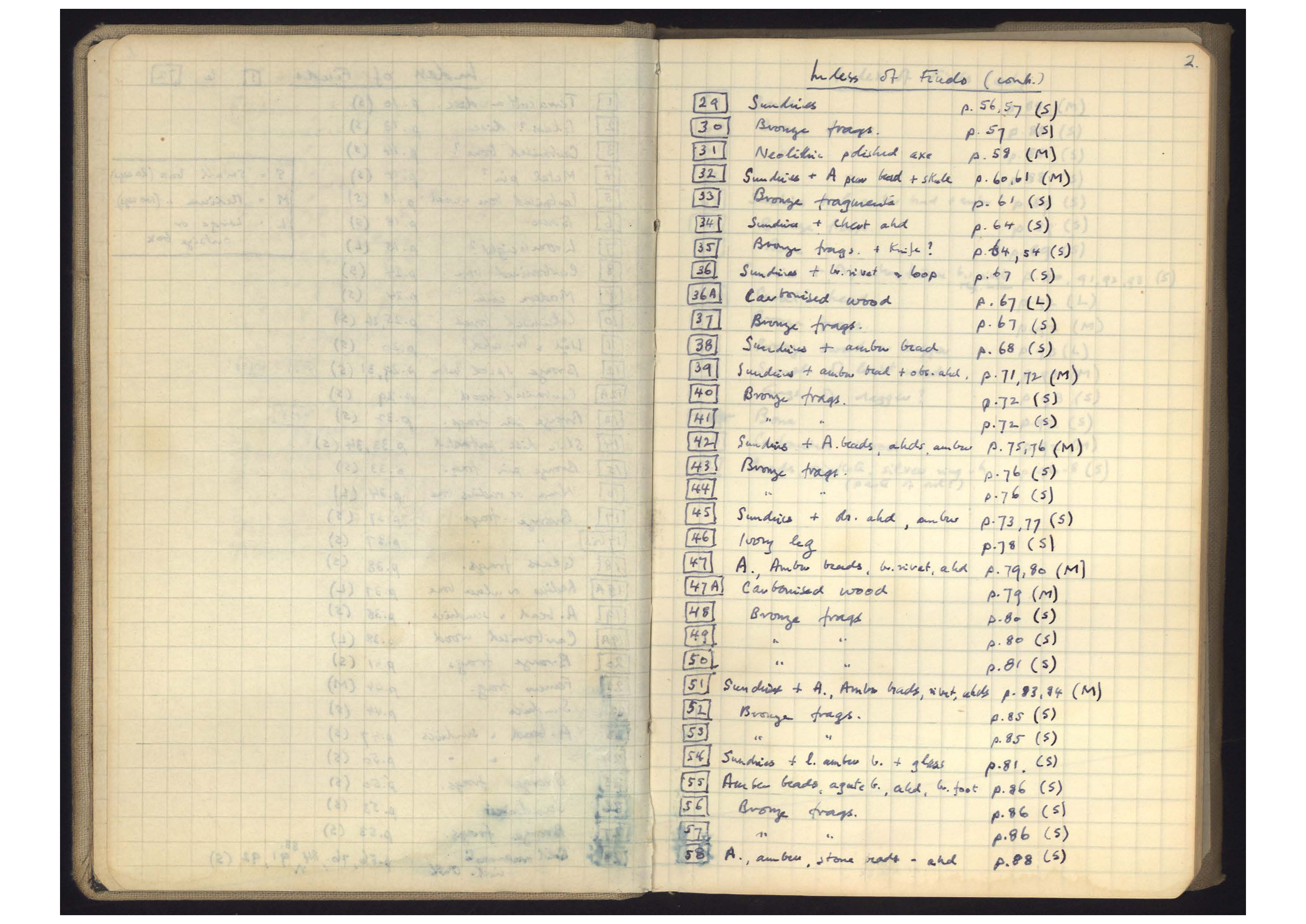
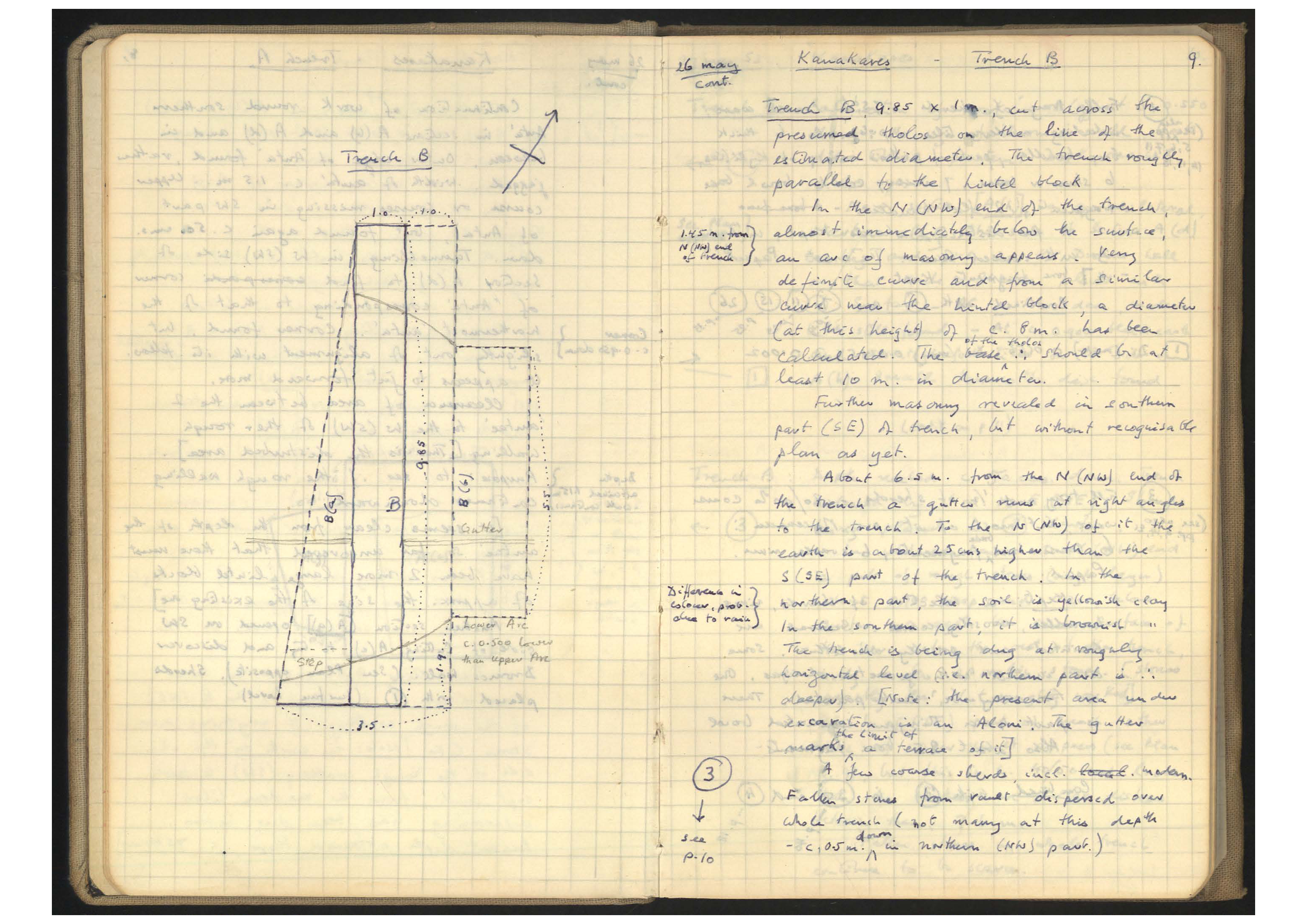
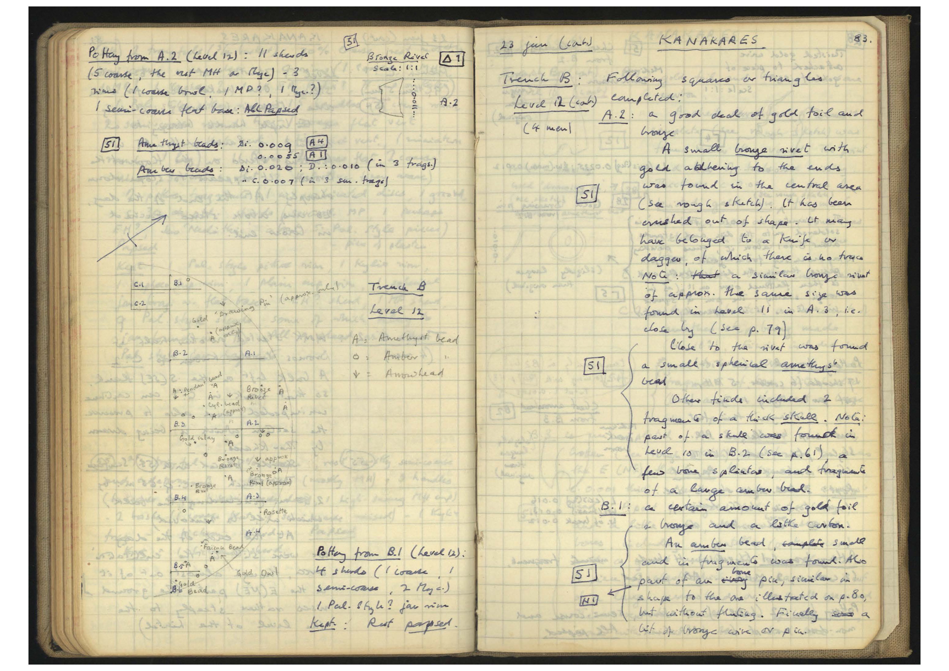
Figure 5: Scans from the notebooks of Lord William Taylour (ASCSA Archives, Pylos Excavations Archive, Box 1, 'Pylos 1953 WDT Kanakares, part I', 'Pylos 1953 WDT Kanakares, part II' and 'Pylos 1953 WDT Kanakares, part III'), indicative of his recording style: Figure 5a shows his itemised running list of finds with page number cross-references; Figure 5b illustrates a technical sketch during the laying out of the first trenches across the top of the chamber, with facing narrative description; Figure 5c shows a sketch of the grid-plan used during the excavation of the final levels of the chamber, with some description of objects found.
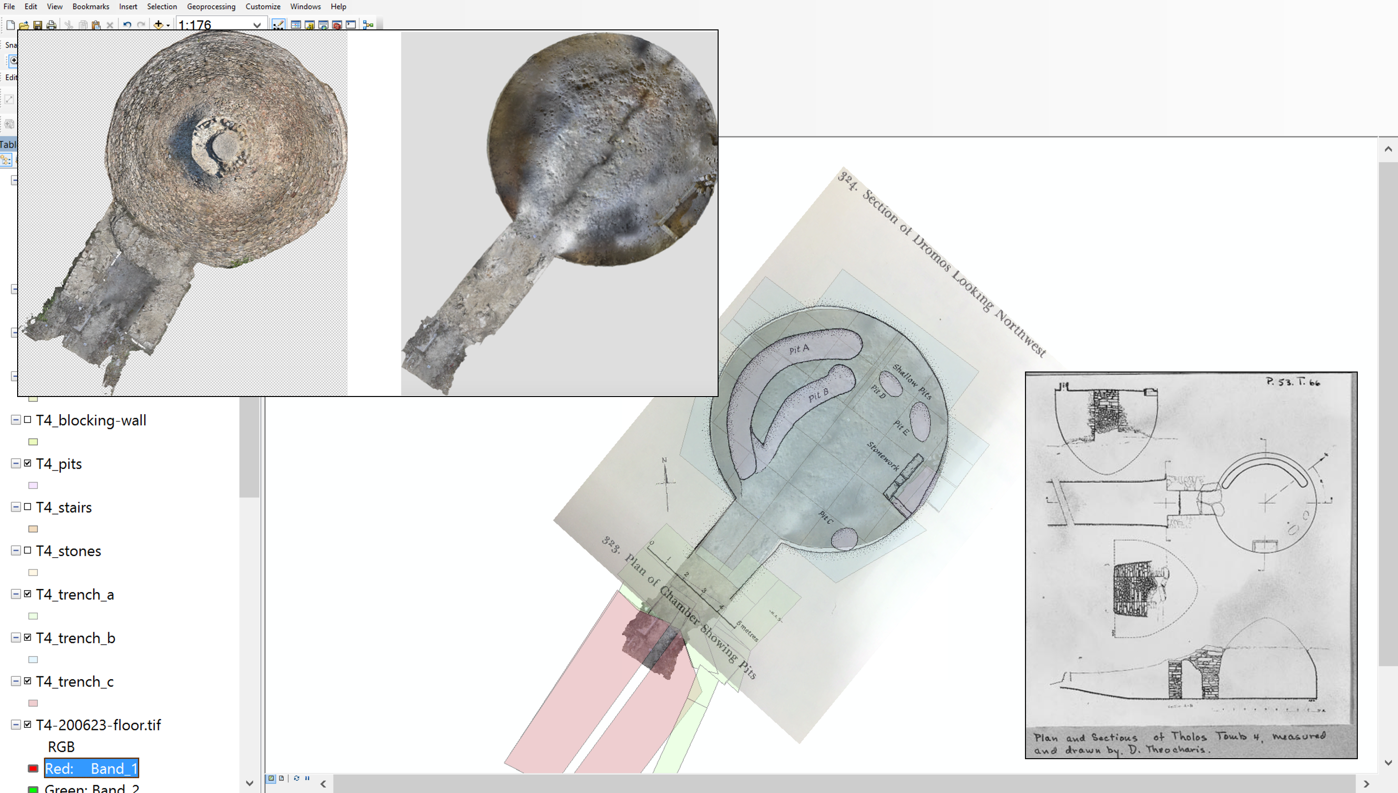
Figure 6: GIS workspace, indicating the overlay of Demetrios Theocharis' architectural plans with the photogrammetry TIF export of the Tholos IV floor. Superimposed to the top left are the top-down images of the tholos as exported from ArcSoft Photoscan, indicating that the floorplan is a 'slice' taken out of the georectified model. Superimposed to the bottom right is another plan and section by Theocharis, showing the level of technical information available for this excavation.
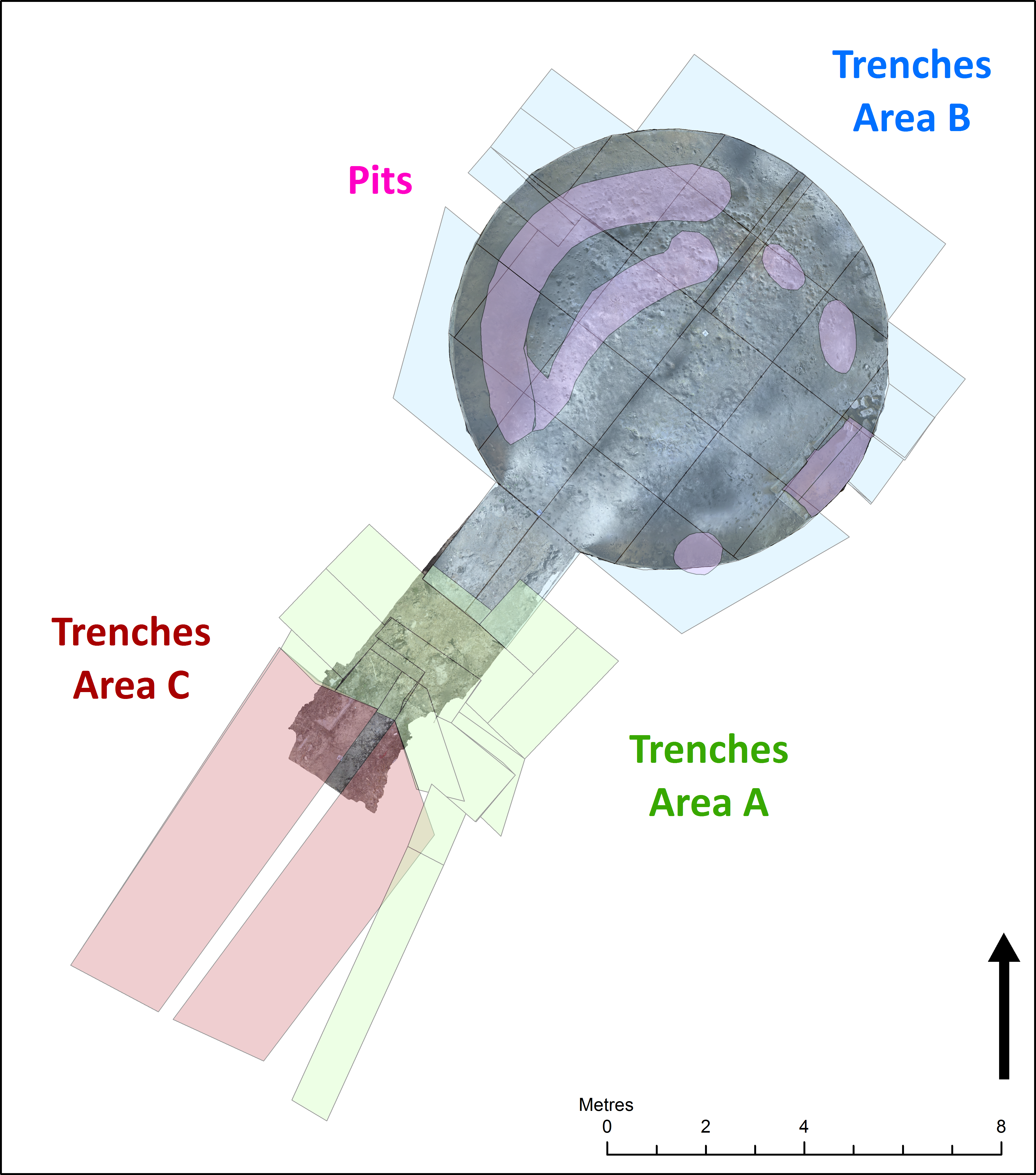
Figure 7: Trench locations, superimposed on the photogrammetry TIF export of the Tholos IV floor. 'A' trenches were opened around the stomion, while 'B' trenches cover the chamber. Trenches in these two areas were opened almost simultaneously, whereas the dromos trenches in area 'C' could only be opened late in the campaign owing to the need to obtain permissions from the landowner.
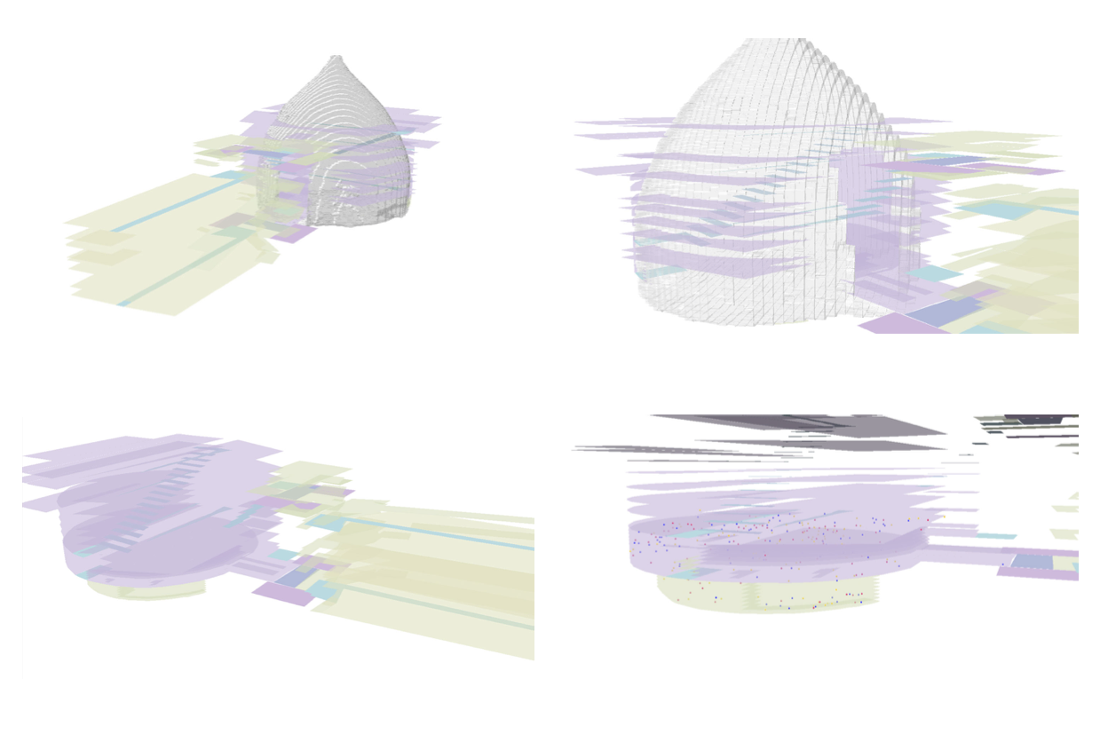
Figure 8: Screenshots taken from ArcScene showing the 3d reconstruction of levels and finds. Going clockwise and starting in the top left, the first and second images include a transparent overlay of the chamber, exported from Photoscan as a COLLADA file. The bottom left image shows the levels with absolute elevation values assigned, while the bottom right image also indicates the distribution of amber (yellow points), amethyst (red points) and gold (blue points) throughout the excavation.
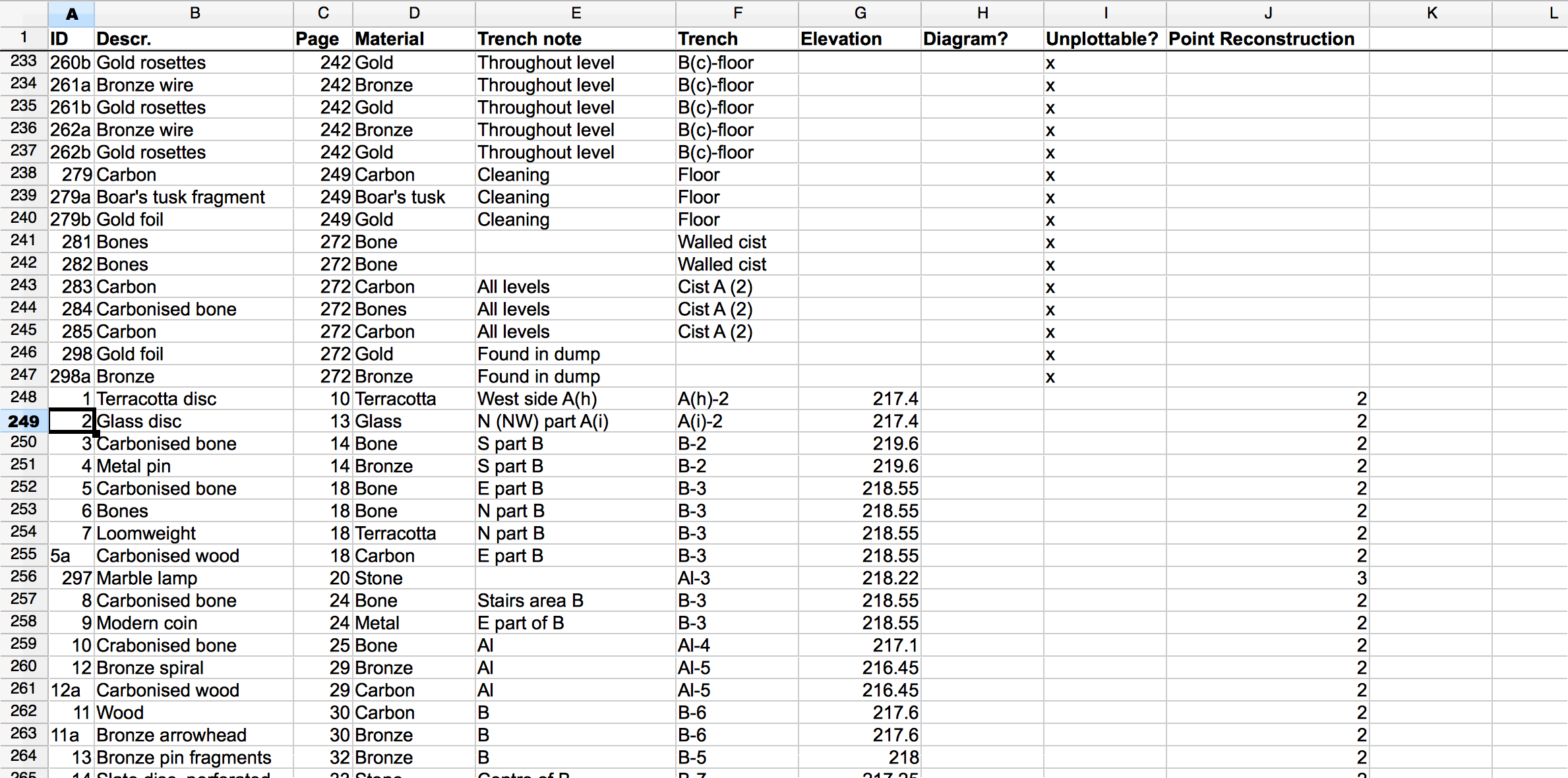
Figure 9: Screenshot from a CSV printout of the Tholos IV data of small finds, extracted from attribute tables linked to GIS layers. The method of findspot location reconstruction is recorded as a column of metadata, on a three-point system. Objects tagged '1' were located using sketches of the trench layouts; objects tagged '2' were located on the basis of general descriptions from the text narratives; objects tagged '3' were placed at random locations within the trench-level extents.
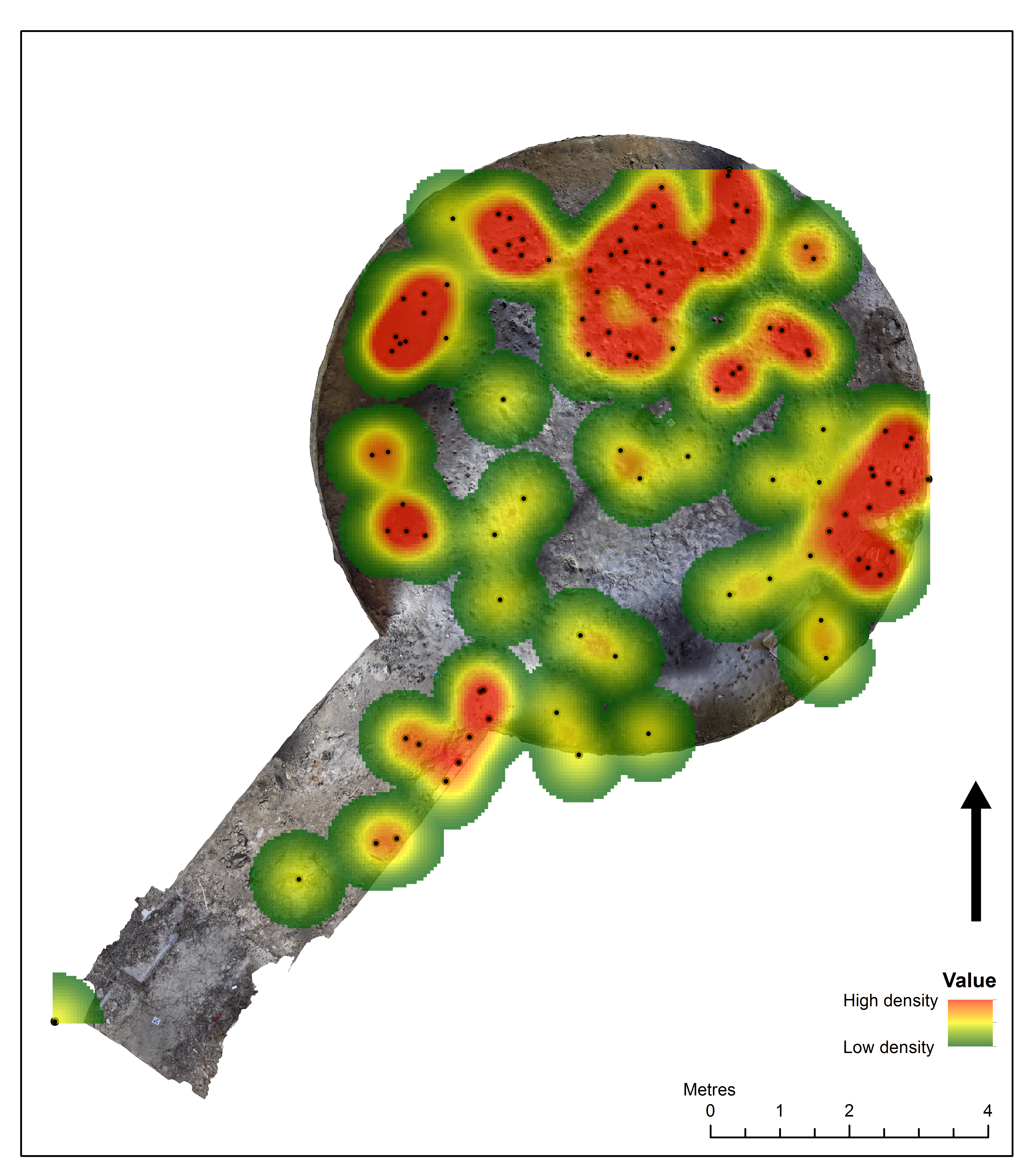
Figure 10: Heat map analysis showing the possible location and distribution of bronze pieces found in the excavation of Tholos IV. Heat map point radii are set to 0.7m, consistent with the highest assumed level of inaccuracy for any of the point coordinates reconstructed.
3D model: Tholos IV, Palace of Nestor. 3D model of the 1957 reconstructed tomb. This photogrammetry model is synthesised from four separate models (chamber, antas, lintel stone, and domed roof exterior).
Allison, P. 2008a 'Dealing with Legacy Data - an introduction', Internet Archaeology 24. https://doi.org/10.11141/ia.24.8
Allison, P. 2008b 'Measuring women's influence on Roman military life: using GIS on published excavation reports from the German frontier', Internet Archaeology 24. https://doi.org/10.11141/ia.24.5
Blegen, C. 1954 'An early Tholos Tomb in Western Messenia', Hesperia 23(2), 158-62. https://doi.org/10.2307/146694
Blegen, C. and Rawson, M. (eds) 1973 The Palace of Nestor at Pylos in Western Messenia. Volume III. Acropolis and Lower Town. Tholoi, Grave Circle, and Chamber Tombs. Discoveries outside the citadel, Princeton: Princeton University Press.
Clarke, M. 2015 'The digital dilemma: preservation and the digital archaeological record', Advances in Archaeological Practices 3(4), 313-30. https://doi.org/10.7183/2326-3768.3.4.313
Dibble, H. and McPherron, S. 2010 EDMWIN 2010. https://www.oldstoneage.com/osa/tech/edmwin/
Ellis, S.J.R., Gregory, T.E., Poehler, E.E. and Cole, K.R. 2008 'Integrating legacy data into a new method for studying architecture: a case study from Isthmia, Greece', Internet Archaeology 24. https://doi.org/10.11141/ia.24.3
Esteva, M., Trelogan, J., Rabinowitz, A., Walling, D. and Pipkin, S. 2010 'From site to long-term preservation: a reflexive system to manage and archive digital archaeological data' in IS&T's Archiving 2010 - Preservation Strategies and Imaging Technologies for Cultural Heritage Institutions and Memory Organizations Final Program and Proceedings (Den Haag, Netherlands 1-4 June 2010) Springfield, VA: Society for Imaging Science & Technology. 1-6.
González-Tennant, E. 2016 'Recent Directions and Future Developments in Geographic Information Systems for Historical Archaeology', Historical Archaeology, 50(3), 24-49. https://doi.org/10.1007/BF03377332
Heaton, P.J. 2003 'Farmsteads and finances in the Finger Lakes: using archival resources in a GIS database', Northeast Historical Archaeology 32, 29-44. https://doi.org/10.22191/neha/vol32/iss1/4
Katsianis, M., Tsipidis, S. and Kalisperakis, I. 2015 'Enhancing excavation archives using 3D spatial technologies' in C. Papadopoulos, E. Paliou, A. Chrysanthi, E. Kotoula and A. Sarris (eds) Archaeological Research in the Digital Age. Proceedings of the 1st conference on Computer Applications and Quantitative Methods in Archaeology Greek Chapter (CAA-GR), Rethymno, 6-8/3/2014. 46-54. IMS-FORTH.
Kourouniotes, K. 1914 'Πύλου Μεσσηνιακῆς θολωτὸς τάφος', Archaiologiki Ephimeris 99-117.
Kourouniotes, K. 1929 'ΠΕΡΙ ΤΟΥ ΘΟΛΩΤΟΥ ΤΑΦΟΥ ΟΣΜΑΝΑΓΑ ΠΥΛΟΥ', Praktika tis en Athinais Archaiologikis Etaireias 1925-1926, 140-1.
Landeschi, G., Apel, J., Lundström, V., Storå, J., Lindgren, S., Dell'Unto, N. 2019 'Re-enacting the sequence: combined digital methods to study a prehistoric cave', Archaeological and Anthropological Sciences 11, 2805-19. https://doi.org/10.1007/s12520-018-0724-5
Marvell, A. 2014 Standard and Guidance for Historic Environment Desk-based Assessment, Reading: Chartered Institute for Archaeologists.
May, K. 2020 'The Matrix: connecting time and space in archaeological stratigraphic records and archives', Internet Archaeology 55. https://doi.org/10.11141/ia.55.8
Mihai, S., Lundberg, J., McFarlane, D. and Chandler, B. 2020 'Pengelly's legacy reconsidered: a GIS approach to spatial analysis of palaeontological and archaeological collections from Kents Cavern, England', Proceedings of the Geologists' Association 121, 319-25. https://doi.org/10.1016/j.pgeola.2010.07.003
Rambach, J. 2014a 'Π.Ο.Τ.Α Ρωμανού Μεσσηνίας', Archaiologikon Deltion 62 (2007), 351-4.
Rambach, J. 2014b 'Θέση Π.Ο.Τ.Α. Ρωμανού - Coasta Navarino - Navarino Dunes', Archaiologikon Deltion 63 (2008), 399-403.
Rambach, J. 2014c 'Π.Ο.Τ.Α. ΡΩΜΑΝΟΥ - Costa Navarino - Navarino Dunes', Archaiologikon Deltion 64 (2009), 361-4.
Richards-Rissetto, H. and Landau, K. 2019 Digitally-Mediated Practices of Geospatial Archaeological Data: Transformation, Integration, & Interpretation, Anthropology Faculty Publications 163. https://doi.org/10.5334/jcaa.30
Schepartz, L.A., Miller-Antonio, S. and Murphy, J.M.A. 2009 'Differential health among the Mycenaeans of Messenia: status, sex, and dental health at Pylos' in L.A. Schepartz, S.C. Fox and C. Bourbou (eds) New Directions in the Skeletal Biology of Greece, Athens: The American School of Classical Studies at Athens. 155-74.
Schepartz, L.A., Papathanasiou, A., Miller-Antonio, S., Stocker, S.R., Davis, J.L., Murphy, J.M.A., Malapani, E. and Richards, M. 2011 'No seat at the table? Mycenaean women's diet and health in Pylos, Greece' in L.A. Shepartz (ed) Anthropology à La Carte: The Evolution and Diversity of Human Diet, San Diego. 359-74.
Schepartz, L.A., Stocker, S.R., Davis, J.L., Papathanasiou, A., Miller-Antonio, S., Murphy, J.M.A., Richards, M.P. and Malapani, E. 2017 'Mycenaean hierarchy and gender roles: diet and health inequalities in Late Bronze Age Pylos, Greece' in H. Klaus, A. Harvey and M.N. Cohen (eds Bones of Complexity: Bioarchaeological Case Studies of Social Organization and Skeletal Biology, University Press of Florida. 141-72. https://doi.org/10.2307/j.ctvx07bk4.12
Steele, L. and Frey, J. 2018 'Using GIS to Explore Legacy Spatial Data at Isthmia', poster presented at the Archaeological Institute of America Annual Meeting, Boston, Massachusetts (Boston Marriott: Copley Place), 4-7 January 2018. https://www.researchgate.net/publication/324524927_Using_GIS_to_Explore_Legacy_Spatial_Data_at_Isthmia
Taylour, W. 1973 'Tholos Tomb IV' in C. Blegen and M. Rawson (eds) The Palace of Nestor at Pylos in Western Messenia. Volume III. Acropolis and Lower Town. Tholoi, Grave Circle, and Chamber Tombs. Discoveries outside the citadel, Princeton: Princeton University Press. 95-134.
Vassallo, V. 2019 'Re-examining a 20th century archaeological excavation in 3D GIS. The Ayia Irini (Cyprus) sanctuary and its finds', International Conference on Cultural Heritage and New Technologies, CHNT 24. PDF
Wallace, C.A.B. 2017 'Retrospective photogrammetry in Greek archaeology', Studies in Digital Heritage 1(2), 607-26. https://doi.org/10.14434/sdh.v1i2.23251
Witcher, R. 2008 '(Re)surveying Mediterranean Rural Landscapes: GIS and legacy survey data', Internet Archaeology 24. https://doi.org/10.11141/ia.24.2
Woywitka, R. and Beaudoin, A. 2009 'Legacy databases and GIS: a discussion of the issues illustrated by a case study of archaeological site data from southeast Alberta, Canada', The Canadian Geographer 53(4), 462-72. https://doi.org/10.1111/j.1541-0064.2009.00282.x
Wylie, A. 2017 'How archaeological evidence bites back: strategies for putting old data to work in new ways', Science, Technology, & Human Values 42(2), 203-25. https://doi.org/10.1177/0162243916671200
Internet Archaeology is an open access journal based in the Department of Archaeology, University of York. Except where otherwise noted, content from this work may be used under the terms of the Creative Commons Attribution 3.0 (CC BY) Unported licence, which permits unrestricted use, distribution, and reproduction in any medium, provided that attribution to the author(s), the title of the work, the Internet Archaeology journal and the relevant URL/DOI are given.
Terms and Conditions | Legal Statements | Privacy Policy | Cookies Policy | Citing Internet Archaeology
Internet Archaeology content is preserved for the long term with the Archaeology Data Service. Help sustain and support open access publication by donating to our Open Access Archaeology Fund.
 Home
Home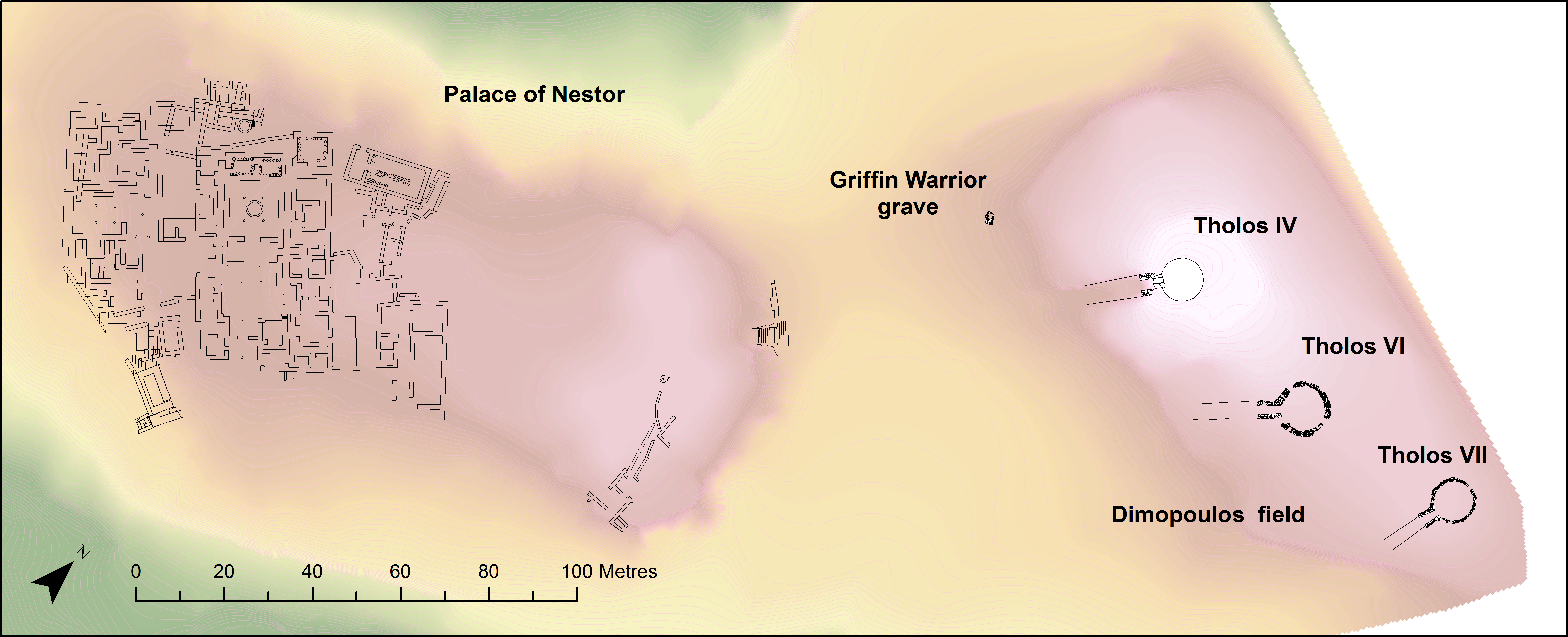