Cite this as: Villa González, A.J. 2022 The Guadalperal Dolmen (Cáceres, Spain). Archaeological and heritage protection interventions on an artificially submerged archaeological site which resurfaces, Internet Archaeology 60. https://doi.org/10.11141/ia.60.4
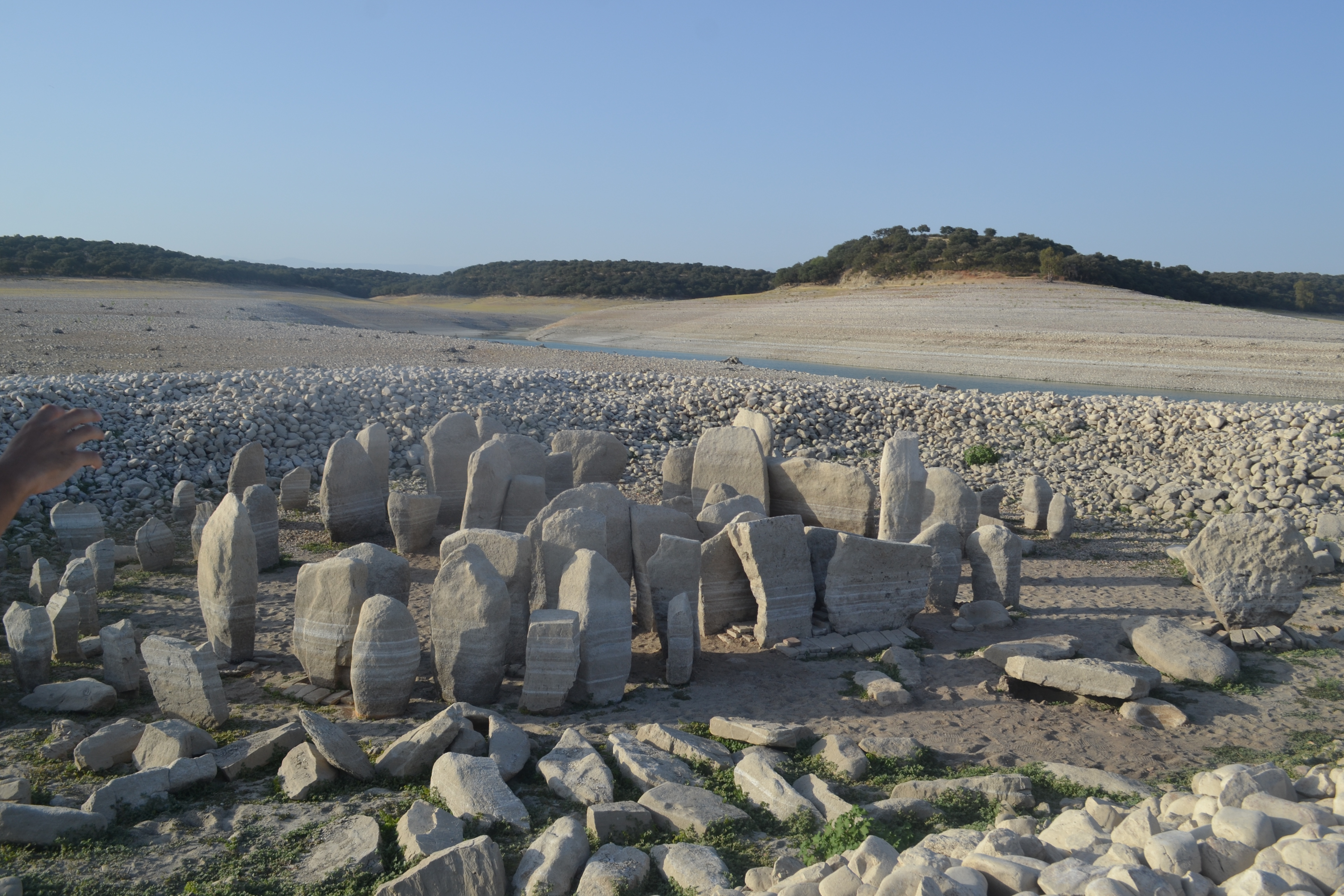
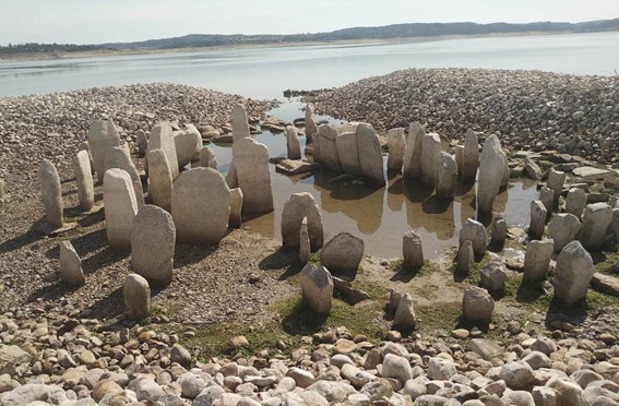
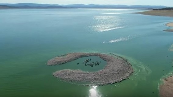
In 1963, several heritage and archaeological sites, such as the Roman city of Augustóbriga and the protohistoric dolmen of Guadalperal, were completely submerged when a reservoir was built in the area. In 2019, the Iberian Peninsula suffered the worst drought in recent decades; the lack of rain and the water to feed the rivers meant a clear reduction in water levels at Spanish reservoirs. This situation allowed flooded lands to re-appear, and in many cases they were accessible on foot, such as at the Valdecañas reservoir (Cáceres). The Dolmen of Guadalperal (made of approximately 150 orthostats) was a spectacular sight when it re-emerged and attracted several curious visitors and the media, who understood that this was a unique opportunity to visit it. The responsible administration therefore needed to act by protecting and archaeologically studying the site.
The Valdecañas reservoir is located within the western boundary of the Tagus river basin in a region known as Campo Arañuelo in Cáceres (Extremadura). Historically, the meanders and the irregular width of the river along its course have structured the area, which has led to the need for fords in places. This, combined with the great agricultural capacity of the area, enabled the proliferation of settlements from prehistoric times until 1963, the year of the creation of the reservoir that flooded them and the town of Talavera la Vieja. Before the flooding, this area was investigated by García y Bellido and Menéndez Pidal, who catalogued part of the archaeological remains, such as the Roman city of Augustóbriga. This work, as well as recent studies carried out when the reduction in the water level allows, have located remains from prehistoric, Neolithic, Bronze and Iron Age, Roman and even medieval times in some rural settlements.
Some of these remains were reconstructed nearby to avoid being totally submerged in water, such as the 'Temple of the Marbles', now located on the bank of the reservoir. The Guadalperal Dolmen (see Figures) is one of the prehistoric sites identified during these surveys.
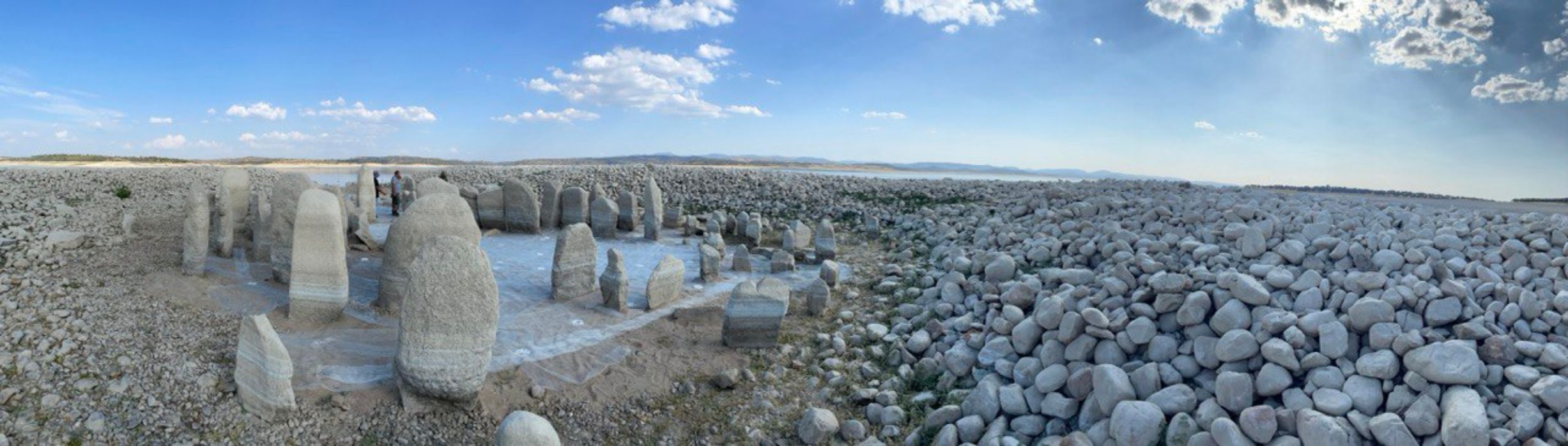
The dolmen is a corridor tomb with a funerary chamber, about 5m in diameter, and includes 10m of passage corridor. Because of its typology and part of its associated material culture (such as a set of bell beakers), the dolmen construction can be placed between the fourth and third millennium BCE, but other ceramic and lithic industry elements suggest an earlier first phase of use. It was excavated between 1925 and 1927 by the archaeologist Hugo Obermaier, who also restored it by repositioning the orthostats on concrete bases and placing the pebbles that formed the tumulus in a ring surrounding the megalithic complex. The archaeological material recovered from the excavations belonged to the House of Alba (owners of the land) and the archive resulting from the intervention was delivered to the University of Freiburg.
After being submerged in the reservoir, some of the upper parts of the orthostats continued to be visible in the summer, but the changing climate means that sometimes it is now completely uncovered and can be 'easily' accessed on foot, as was the case in 2019. This has led to a massive influx of tourists to the site, despite the two-hour walk through muddy terrain to reach it. This also meant that these visitors reached the area by strolling through private property and even putting their health at risk as a result of the intense heat and the complexity of the terrain. It was such a phenomenon that it was widely reported in the media, and the site came to be known as the 'Spanish Stonehenge'.
All this activity alerted both the surrounding towns, such as Peralada de la Mata, and the various national administrations. These comprised of the Central Government (the land is state-owned and when the reservoir was created, it was purchased by the Government and became part of the Tagus River Basin, currently under the Ministry of Ecological Transition and Demographic Challenge) and the Regional Government of Extremadura, responsible for some of the archaeological and heritage protection monitoring (transferred by the Central Government).
Initial actions were carried out in 2019 by the Department of Fine Arts of the Spanish Ministry of Culture and Sports. The state of the land was verified in situ and some initial emergency measures for its stabilisation were carried out. In October 2019, the waters of the reservoir rose, which meant that the site was once again inaccessible. In May 2020 the Ministry of Culture and Sports drew up a contract with the University of Alcalá de Henares for its researchers to carry out documentation and archaeological intervention on the megalithic complex and its surroundings.
Four phases of work were agreed: the first two phases were dedicated to cataloguing, documenting, intensive prospecting, and general evaluation of the surroundings. The latter phases were devoted to the archaeological intervention and detailed study of the site.
Today, an exhaustive cartographic information project has been completed, carrying out a georeferenced map in which not only the remains are located (the Dolmen and the other archaeological sites in the area), but also the areas of influence of each of them are established to trace areas of special relevance. It is possible, thanks to the interoperability offered by the Geopackage data format, for future researchers or managers to check the geometric records obtained, since one of its objectives is supporting good archaeological practice, taking as a reference the tradition of analysis of European cultural landscapes. At the end of 2020, and since the remains were once again underwater, a detailed bathymetric survey was carried out by the Ministry of Culture and Sports not only for the Dolmen but also for the Roman site of Augustóbriga. This study was under the scientific direction of the Complutense University of Madrid and the ARQUA Museum, with the collaboration of the Regional Government of Extremadura and the Ministry of Defence.
Both prospecting studies confirmed the heritage, cultural and archaeological relevance of the whole area, which strengthened the need to give it the highest degree of protection currently existing in our country: the declaration as a 'Bien de Interés Cultural' (BIC), which translates as a 'Good of Cultural Interest'.
On 22 December 2020, the Government initiated the procedure. This process, regulated by the Spanish Historical Heritage Law, establishes that the provisional application affords the same protection regime as for sites that are already declared as 'goods of cultural interest'. This regime records the sites in a register identifying them, and also contains all legal or artistic acts carried out, the obligation to regulate their inspection, investigation and access and, in the case of immobile assets (as in this case), the impossibility of disassociating them from their surroundings.
The declaration as a Good of Cultural Interest is being initiated under the category of 'Archaeological Site', which the law itself defines as 'a place or natural site where there are movable or immovable goods susceptible of being studied with archaeological methodology, whether or not they have been extracted and whether they are on the surface, in the subsoil or under Spanish territorial waters'.
To initiate the declaration (as with all declarations of the same nature carried out by the Central Government), mandatory reports carried out by advisory bodies specialising in the matter, such as the Royal Academy of History or the Royal Academy of Fine Arts of San Fernando (RABASF), were required. The report of the Royal Academy of History established the need to carry out a three-dimensional study and a systematic excavation, and to take all the necessary essential measures to ensure its conservation. The RABASF report emphasised the risk of a relocation as the site's historical values and the landscape relationship with its territory would be lost.
In the specific case of the Guadalperal Dolmen and its archaeological site, the declaration as BIC (Good of Cultural Interest) has, as we have seen, several direct consequences. It will necessitate the creation of a special protection plan that will regulate its inspection, research and public visits and it will impose an absolute ban on disassociating any of its elements. All of this is truly relevant because of the special characteristics of the location. However, it will also indirectly mean that its recognition will be a way of facilitating the diffusion of its heritage value (both the value already known and that obtained after accomplishing the new research) as well as its relationship with the other heritage sites in its nearby surroundings, whether archaeological, historical, artistic, or ethnographic. All of these, together with the natural environment within which they are an inherent part, form our cultural landscape, a landscape that has been shaped throughout our history and in which even the elements that have distorted it, such as creating a large reservoir that flooded it, are part of its context; hence an integral management approach is required.
The landscape has been modified by two fundamental factors: climate and humankind. While climate cyclical variations needed centuries to transform the landscape, human action has provoked much more abrupt mutations, not only in its physical reality but also by facilitating the acceleration of climate change itself, accelerated in such a way that creates a clear risk to the environment in which our lives take place.
Archaeology should be one of the sciences that helps us to understand what the landscapes of our past generations were like, and that guides action to avoid the degradation generated by human activity, so it does not endanger our present natural and cultural environment. This requires teamwork between the different branches of the discipline, as we see in the example of the Guadalperal Dolmen.
Preventive archaeology and its development through research form an initial step from which management archaeology (developed specially by public administrations) can proceed to guarantee that the remains or vestiges of the past and the information related to past societies and their landscapes serve to shape a more sustainable future.
Internet Archaeology is an open access journal based in the Department of Archaeology, University of York. Except where otherwise noted, content from this work may be used under the terms of the Creative Commons Attribution 3.0 (CC BY) Unported licence, which permits unrestricted use, distribution, and reproduction in any medium, provided that attribution to the author(s), the title of the work, the Internet Archaeology journal and the relevant URL/DOI are given.
Terms and Conditions | Legal Statements | Privacy Policy | Cookies Policy | Citing Internet Archaeology
Internet Archaeology content is preserved for the long term with the Archaeology Data Service. Help sustain and support open access publication by donating to our Open Access Archaeology Fund.
 Home
Home