Cite this as: Jackson, N., Casswell, C. and Forster, M. 2023 A Medieval Drawbridge Pit and the Stories it Tells Us, Excavations at Pontefract Castle, 2019–2020, Internet Archaeology 61. https://doi.org/10.11141/ia.61.4
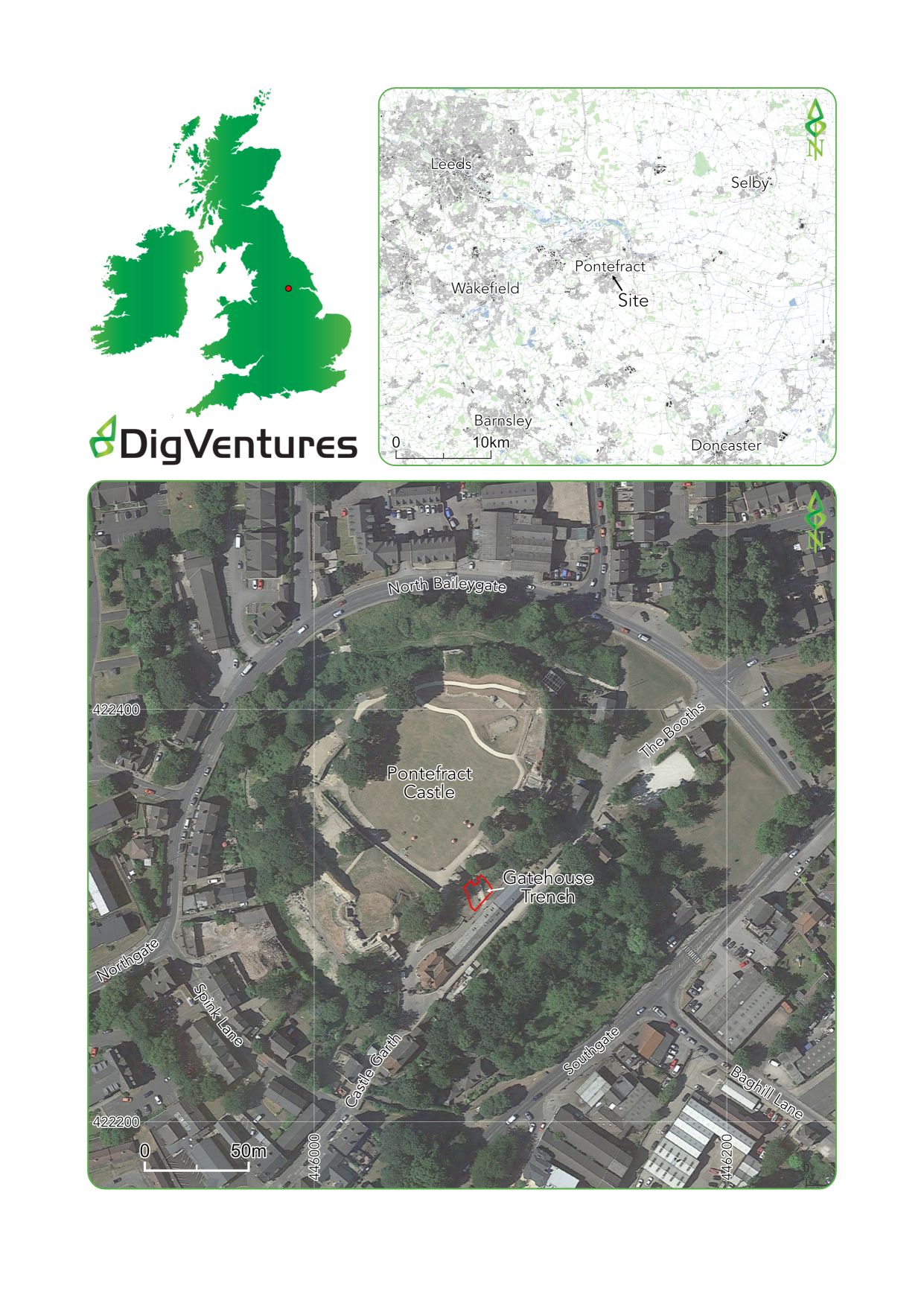
DigVentures was commissioned by Wakefield Metropolitan District Council (WMDC) to undertake a programme of archaeological investigations as part of the Gatehouse Project, a community-focused archaeological research project based at Pontefract Castle, West Yorkshire (Figure 1). The Project Design was developed by DigVentures (Casswell et al. 2019; 2020) in consultation with both WMDC and Historic England. The project was supported by Historic England, with funding allocated under the terms of the NPPF Emergency Investigation Assistance (project no. 7737).
A full technical analysis report has been produced by Casswell et al. (2021), which includes detailed archaeological results and specialist analysis from the project team and contributing authors: Karen Barker, Chris Cumberpatch, Elizabeth Foulds, Josh Hogue, Nat Jackson, Indie Jago, Gerry McDonnell, Stuart Noon, Maiya Pina-Dacier, Hannah Russ, Carl Savage, Ruth Shaffrey, Ellen Simmons, Harriet Tatton, Johanna Ungemach, David Wallace and Brendon Wilkins. Individual specialist reports are also included in the digital archive, with supporting data. This publication draws on the results of that analysis, presenting a discussion of the excavations of the medieval drawbridge pit at Pontefract Castle.
Pontefract Castle is strategically situated on an outcrop that formerly commanded two of England's principal highways – the Great North Road and the route west over the River Aire. The crossing point at Ferrybridge, just to the north of Pontefract, was also the site of fighting prior to the Battle of Towton (1461) and the Pennines. The site is located towards the north-eastern extent of the historic core of modern Pontefract (SE 46075 22320; Figure 1) on a promontory formed of sandstone (Pontefract Rock) interbedded with coal measures, at a height of c. 50m aOD.
Now owned by the Duchy of Lancaster and managed by Wakefield Metropolitan District Council, Pontefract Castle is a Scheduled Monument (NHLE ref. no. 1010127) and one of Pontefract's most identifiable landmarks. Despite its visibility, much is still unknown about the castle, as recent discoveries made during the investigations at the inner bailey gatehouse demonstrate.
This stage of archaeological fieldwork was undertaken in two phases. During 2019, an initial phase of work investigated parts of the gatehouse structure exposed during an earlier archaeological watching brief at Pontefract Castle (Burgess 2019), which took place at the base of the Victorian steps leading from the visitor centre into the castle's inner bailey (Casswell et al. 2019). This involved three weeks of excavation with a team of professional archaeologists followed by a two-week programme of participatory archaeology, involving additional excavation, recording and finds processing with members of the local community. The results of the 2019 work led to a second phase of targeted investigation to excavate the full stratigraphic sequence within the previously identified drawbridge pit. This was carried out by professional archaeologists in the late summer of 2020, excavating by hand through sealed deposits exclusively within the pit. This latter phase was restricted to a professional team both by the depth of the excavations and the COVID-19 pandemic, which inhibited on-site engagement with the public. Despite this, the project remained visible and accessible, continuing to serve the WMDC and HE's overarching vision to increase public awareness during the site's redevelopment, and to improve understanding of Pontefract Castle and its environs.
The project design was created in response to an Invitation to Tender (ITT) and Written Scheme of Investigation (WSI) created by West Yorkshire Archaeology Advisory Service, Wakefield MDC and Historic England (ITT - Wakefield MDC 2018; WSI – WYAAS 2018). In addition to the requirements of the archaeological method and outcomes outlined in the WSI, procurement documents highlighted the desire to achieve tangible public engagement and social outcomes as a result of the project's delivery. The procurement process enabled responses to the tender, which demonstrated the proposed archaeological methodology alongside the design for public impact as key demonstrations of quality, rather than relying on price as a primary evaluation criterion. The resulting Project Design consequently included public engagement as one of five archaeological aims, embedding meaningful social impacts within the project model from the outset (Casswell et al. 2019).
The social impact of the archaeological investigations, including project outcomes for heritage, for people and for the community, have been analysed and published in an earlier article (Wilkins et al. 2021). This article focuses on the archaeological evidence recovered during the excavations, and the conclusions drawn about the construction and chronology of the gatehouse at this part of the site.
In the pre-Norman period Pontefract consisted of two townships, Tateshalle and Kirkby, the former being mentioned in the Anglo-Saxon Chronicle as a place where Archbishop Wulfstan and men of Northumbria pledged allegiance to King Eadred of Wessex, and the latter being of ecclesiastical importance with at least three pre-conquest churches present (Roberts and Whittick 2013). It is possible that the large ditch around the motte of the Norman castle was originally a part of the Anglo-Saxon settlement.
The former royal manor and Tateshalle-Kirkby were granted to Ilbert de Lacy by William the Conqueror following the conquest and Pontefract Castle was constructed c. 1070. Although Pontefract was not mentioned in the Domesday Book (1086), there is reference to 'Ilbert's Castle', indicating that construction was well underway at this point (Harfield 1991). The castle was confiscated from the de Lacy family by Henry I in the 12th century and remained Crown property until King John returned it in 1199; this was short lived as it was back in possession of the King by the early 13th century. The de Lacy family continued to live at the castle until 1311 when it passed by marriage into the House of Lancaster and by the end of the 14th century was in the hands of Edward III's son, John of Gaunt. During Gaunt's tenure major rebuilding occurred, including the strengthening of the gatehouse with new polygonal buttresses and several new towers constructed around the curtain wall (Goodall 2022). The castle remained of strategic and administrative importance throughout the 15th century and during the Wars of the Roses before gradually falling into decay in the 16th century.
By the time of the Civil War the castle was a major Royalist stronghold, having profited from repairs undertaken by Charles I between 1618 and 1620. The first Parliamentarian siege of the castle took place in 1644 but was unsuccessful. A second siege began in 1645 where, after hearing of Charles' defeat at the Battle of Naseby, the garrison surrendered. By 1648 the castle was back in Royalist hands, with the final siege taking place in November of that year and the surrender was negotiated after the execution of Charles I in January 1649. Soon after this event, at the request of the local townspeople, the fortifications were slighted, leading to the site's eventual strategic decline.
The site was subsequently used for liquorice cultivation before being converted into a public park by the Victorians in 1883, a move that has helped to preserve the buried remains of a wide range of structures and features relating to all phases of Pontefract's history.
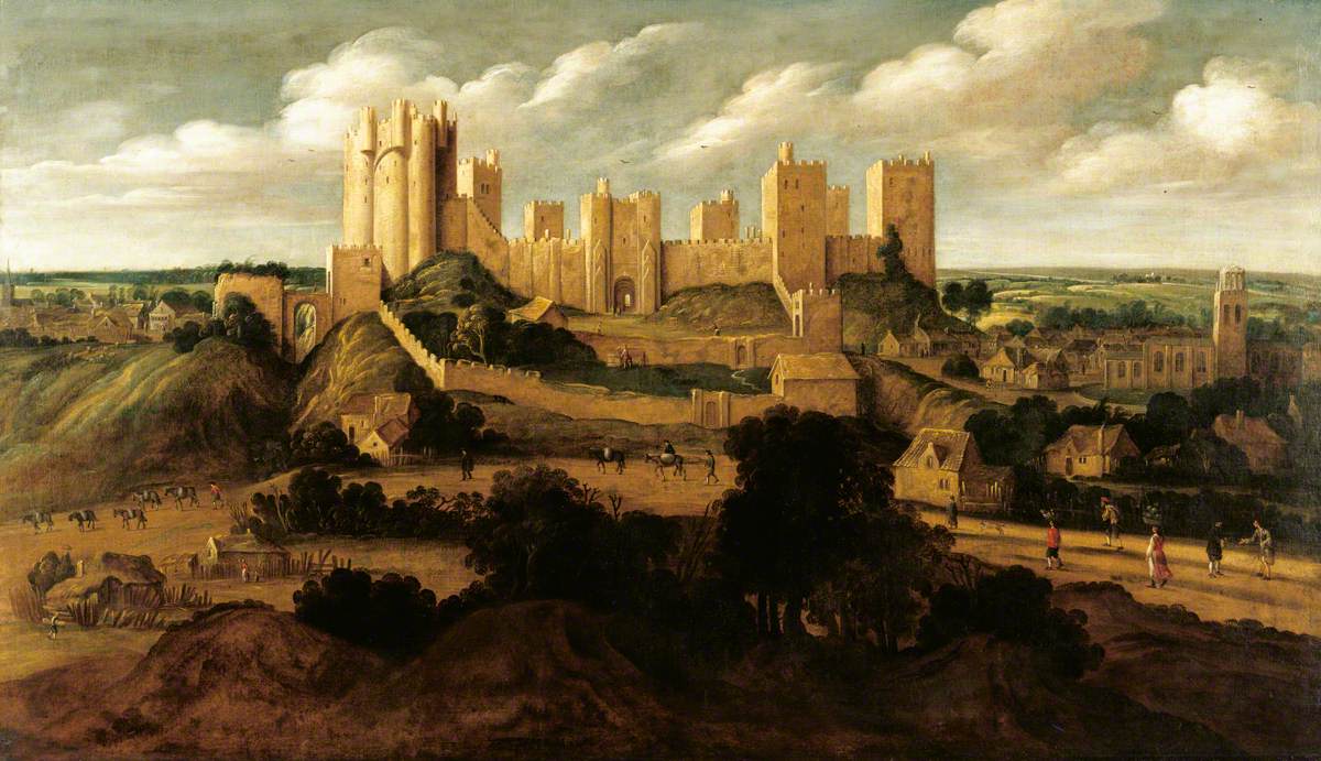
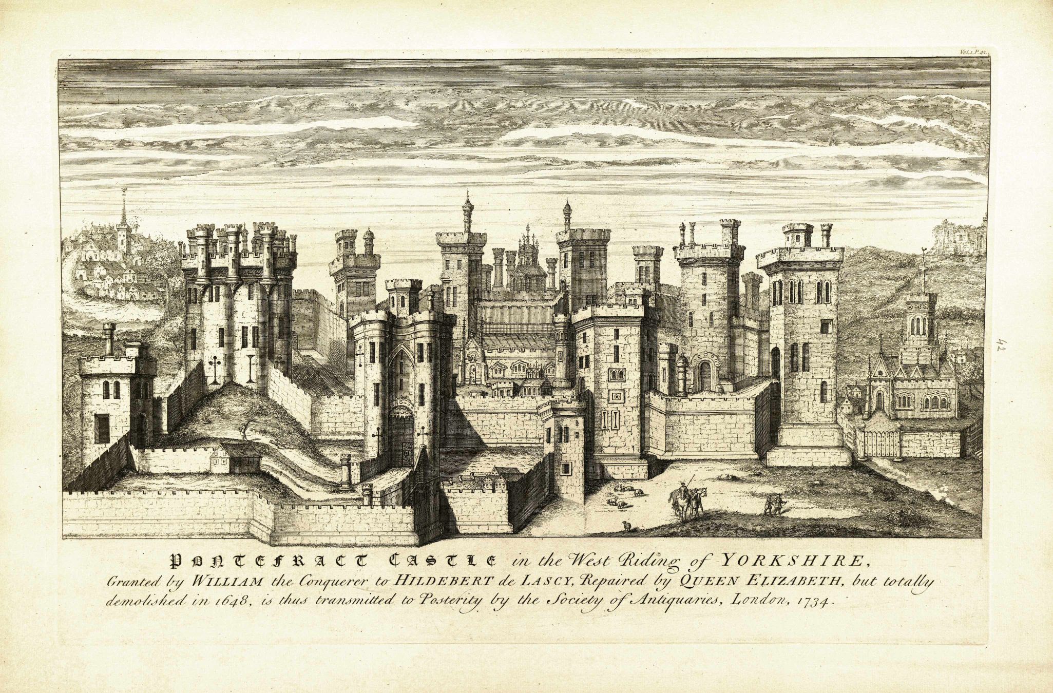
The original Norman gatehouse would have been constructed in timber and its original location is not known; however, because of the nature of the local topography it is most likely to have been in approximately the same position as the stone one that followed. Its renovation to stone was, in all probability, made in the 12th or 13th century and consisted of a simple arched opening in the curtain wall, later converted to a plain rectangular gatehouse. A documentary reference from 1244-46 describes roofing '…the wooden tower in Pontefract Castle with lead' (Roberts 2002 17). The site was developed further during the 13th century to include two drum towers, one either side of the gate. It is known that further additions to the gatehouse were made in the late 14th or early 15th century, although any attempt to phase its construction from the visible extant remains is problematic because of its state of disrepair. Later paintings and engravings from the 17th century onwards depict how the structure may have looked before the fortifications were slighted (see Figures 2 and 3). They show no ditch or drawbridge but do all identify flanking wall gate piers extending from the towers.
The presence of an additional tower between the two main drum towers has been suggested through a description of the site by Richard Holmes (1887), who apparently identified a small roundel projecting from the eastern drum tower at the gatehouse during excavations in the 19th century. This does not appear on any other illustrations and is at odds with what is currently understood to constitute the gatehouse. A large ditch is known to have passed the front of the gatehouse, which was filled by the time of the Civil War, and it is possible that there exist the remains of a drawbridge structure, at least one additional tower, and part of a barbican dating from the 14th century between the Victorian steps and the Visitor Centre.
Early investigations at the Castle appear to have taken place in the 1880s, with excavations referred to by Richard Holmes as taking place around the Great Gateway or Porter's Lodge (Holmes 1887 403). Between 1982 and 1986 a major programme of work was carried out by the West Yorkshire Archaeology Service (Roberts 2002). This work identified evidence of a Christian cemetery belonging to the 10th-century royal town of Tanshelf underlying the inner bailey of the castle, near the 11th-century St Clements's Chapel. WYAS also conducted a geophysical resistance survey in 2012 (Harrison and Harrison 2012) and together these reports have provided an archaeological framework for the 'Gatehouse Project' – motivated by the discovery of previously unidentified buildings associated with a gatehouse complex, revealed during pre-development works in 2016.
Preliminary assessment during a 2016 watching brief (Burgess 2019) suggested that the 13th-century gatehouse was re-fronted by the construction of a third tower set between the drum towers and articulating with a drawbridge pit. The remains of this third tower consisted of a substantial curved masonry structure that appeared to incorporate an internal room. These structures appeared to represent a barbican, a further line of defence, added to the existing gatehouse, and most likely depicted in the 1560 survey drawing. The associated drawbridge pit measured c. 2m wide and, although its length and depth were not revealed during excavation, comparative examples suggested that it may have measured c. 5m long and 2m deep. It was suggested that the drawbridge pit was likely constructed within a pre-existing ditch, necessitating high retaining walls articulating with a bridge structure. The WYAS geophysical survey identified a substantial 10m wide ditch in this locality, though results were constrained owing to the upstanding Victorian tea house, lodge and access road, meaning that the survey could not extend beyond the gatehouse. Although this work is not yet published, the project team have been granted access to the watching brief archive, and an appraisal of the material pertinent to the excavation is included alongside the results of the 2019 investigation below.
The overarching aims of the archaeological investigations were to define and characterise the physical extent of the site through a scheme of non-intrusive and intrusive investigations, combined with an integrated public engagement programme at its core. This approach enabled the collection of baseline data to facilitate the future management, research, presentation and enjoyment of the site. The goal of this work was to fully record, analyse and report all archaeological remains within the area of interest ('preservation by record'); to place the results of this work in the public domain by publishing the results in an appropriate format as agreed by Historic England; and to inform how the Gatehouse might be presented to the public.
The research project was defined following the MoRPHE model (English Heritage 2012), with a series of aims and objectives agreed from the outset (Casswell et al. 2019; Casswell 2020) and devised in accordance with priorities articulated in the Historic England Research Agenda (2017b) and Historic England Corporate Plan (2018).
A series of five aims were set out in the project design, expanded with specific questions and objectives (see Casswell et al. 2019; Casswell 2020).
The methodology used to carry out the aims followed guidelines set out by Historic England (2017a), CIFA (2014a 2014b 2021) and the standards set out within the WSI (Casswell et al. 2019). The public programming was designed by DigVentures in collaboration with WMDC. The excavation was carried out in accordance with the company Health and Safety Policy, to standards defined in The Health and Safety at Work etc. Act 1974, and The Management of Health and Safety at Work Regulations 1992. For a detailed discussion of the methodology see Casswell et al. 2021.
The excavation area was an irregular shape in plan, measuring approximately 15m long and 10m wide between the existing footpath in front of the visitor centre and the base of the steps into the inner bailey - see Gallery 1.


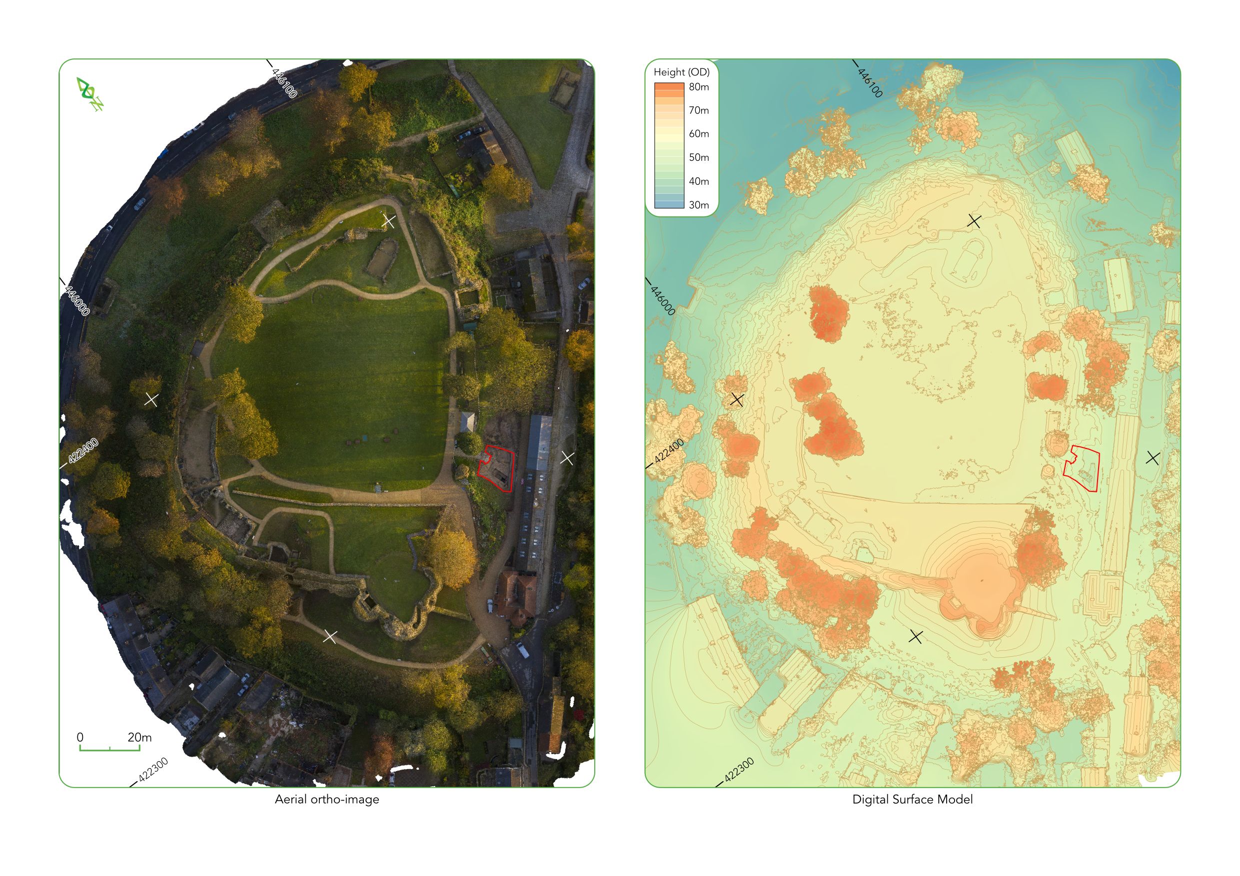
A full technical report can be found on the DigVenture's reports pages, along with the project designs and assessment reports. The working project archive remains accessible, and includes the site records, project timeline and background information. A data paper describing the project archive is also being published, providing a summary of the digital and physical archive, its location and potential (see Jago 2023). The post-excavation plan shows the orthophoto of the trench with features highlighted against a heat map showing the varying elevation of areas across the site (Figure 4).
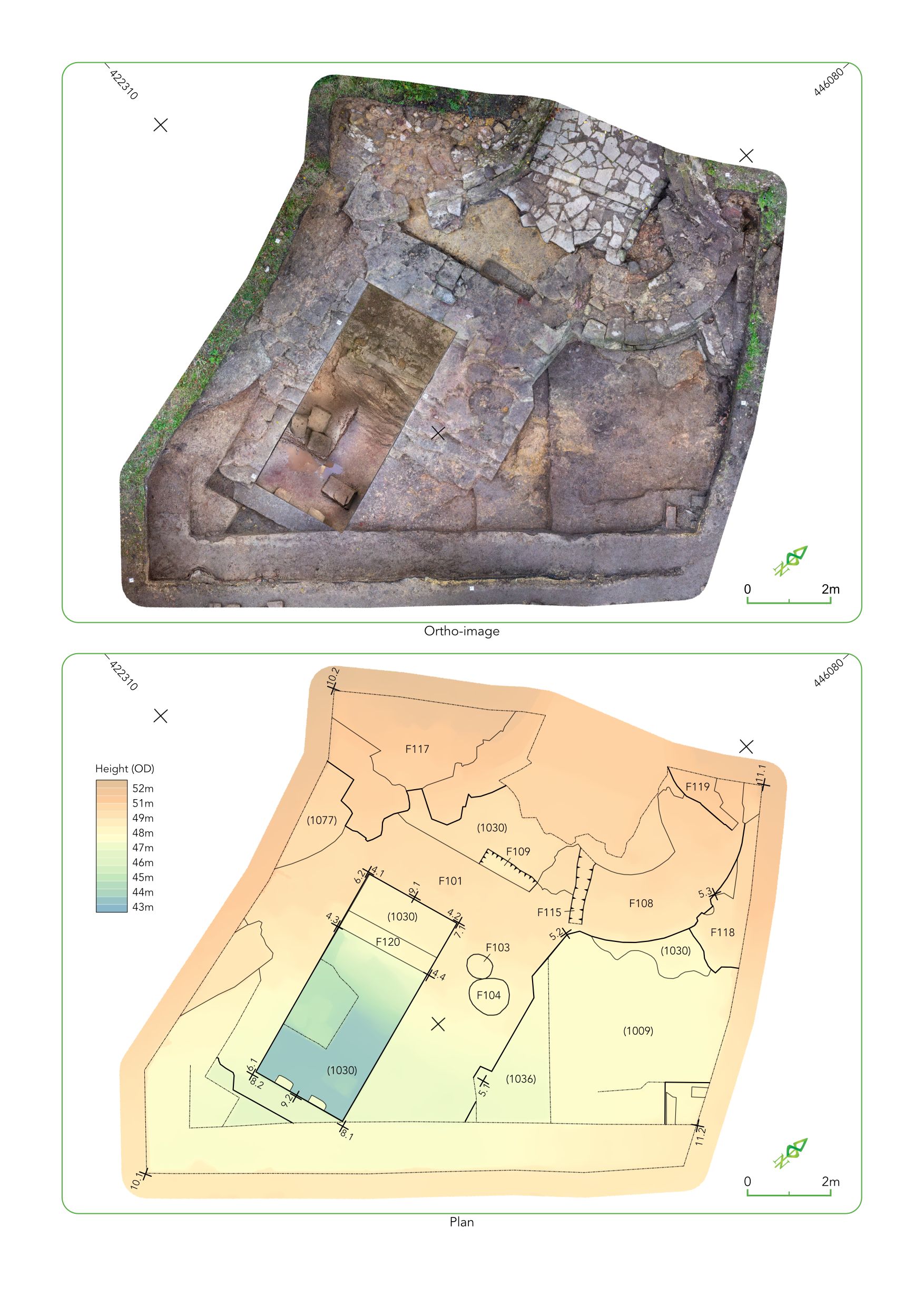
A series of 3D models of the excavations and site can be accessed as part of the digital archive or via Sketchfab, and the post-excavation model is included here as Figure 5.
A total of seven distinct phases of activity were identified within the trench, spanning the 12th century through to the 19th. The earliest phase is represented by a casing wall probably dating to the 12th or 13th centuries. This was seen in front of the natural sandstone edge within the drawbridge pit and consisted of four courses of degraded ashlars. The dating of this wall was problematic but when compared to other remains it appears to have been exposed for significantly longer. Sandstone was quarried locally for building works commissioned at the castle from the 13th century onwards; however, the construction of this wall in limestone indicates it may pre-date these works, having been erected in the 12th or 13th century.
The second phase identified is that of the gatehouse construction in the 14th century. Structural elements were built using sandstone ashlar and included part of the eastern gatehouse tower, an adjoining central tower, and a drawbridge pit extending from what would have been the inner end of a barbican passage. The focus of archaeological activity during the excavation was the drawbridge pit. Structurally, the sections that remained were in excellent condition having survived the demolition of much of the rest of the castle at the end of the Civil War, and careful excavation of the depositional sequence from within provided evidence for its gradual filling from as early as the 14th century.
Based on the excavated evidence, the most reasonable assessment of this feature is that it formed part of a turning bridge system and functioned as a pit into which the rear counterpoised section of a drawbridge was housed when the bridge was raised. The precise workings of the bridge are lost, but the sandstone corbels protruding from the south wall into the pit may have served some function in its operation, with the recesses lower down the wall demonstrating a repeated striking action from above. Alternatively, the bridge may have been operated using lifting bridge technology; however, the lack of chain holes or counterbalance beam slots above the gate on the 16th-century drawing make this suggestion unlikely.
The third phase of activity is the infilling of the drawbridge pit. The nature of much of the remains from within the pit indicates a gradual accumulation of sands from the original construction of the drawbridge pit until the 15th century. The initial phase of infilling produced a varied assemblage of animal bones that included diagnostic pieces from sheep/goat, cattle, deer, pig, carp, mussel and oyster, along with a range of bird remains, including domestic goose, mute swan, fowl, chicken and grey heron (for the full report see Russ in Casswell et al. 2021). Other finds of note from these layers included a late medieval turned bone 'parchment-pricker' or stylus, a heavy copper-alloy object that may have served as part of a pivot for the drawbridge mechanism, and a heavily corroded probable axe. Pottery from the earliest layers consisted predominantly of Humberware dating to the 14th and 15th centuries. Late 15th and 16th century filling of the drawbridge pit consisted of 13 layers. Within these layers a range of animal species were represented including cattle, sheep/goat, goose, pheasant, and edible oyster. While there was some intrusive and residual pottery, most of the assemblage consisted of 15th and 16th century material. Two stone cannon balls were also recovered, one of which showed signs of damage from firing or other reasons. Deposition of material continued throughout the 17th century, with no evidence to suggest that the pit was redefined or maintained prior to the Civil War sieges. This is corroborated by the fact that no moat or bridge is visible in illustrations of the castle dating from the 17th century. It seems unlikely that these features had been completely removed but a lack of emphasis on their defensive nature, combined with the evidence from the infill deposits, suggest they played a limited role within the castle defences by this time.
Phase four was made up of the Civil War defences dating from the mid-17th century. A later piece of masonry was seen crudely bonded to the outer face of the eastern gatehouse tower and the circular tower. This is likely to have been an addition relating to the Civil War fortifications.
The fifth phase was the demolition of the gatehouse, which was known to have taken place directly following the conclusion of the Civil War in 1649 and was clearly evidenced by a thick layer of stone rubble deposits with thin sandy deposits overlaying them. This build-up of material contained very few finds; however, seven musket balls were recovered. The penultimate phase of activity follows on from the demolition and is the deconstruction of the gatehouse from the mid-17th to the mid-19th century. This activity was characterised by pitting over the walls surrounding the drawbridge pit to extract building material. The final phase of activity seen in the excavations was the Victorian remodelling of the site in the 1880s.
The overall preservation of the buried archaeological remains was good across the site. Structural remains located below the level of 19th-century landscaping were sealed by 17th-century demolition rubble and had been preserved in excellent condition. The artefacts recovered were present through the entire excavated sequence and, apart from ferrous material, had survived well in the sandy conditions. By comparison, the recovery of palaeoenvironmental remains was poor, although the faunal assemblage provided rich data.
In total, the excavations yielded an assemblage of 918 sherds of pottery (Cumberpatch 2020), 513 Ceramic Building Material (CBM) fragments (Mills 2021), 239 fragments of metal, stone, glass, bone, antler/ivory, and other ceramic including 17 copper-alloy objects, 40 lead objects, 11 stone objects, five fragments of window glass, two silver coins, one worked bone object, one antler or ivory artefact and one ceramic object (Foulds 2021) and 239 fragments of production waste, including clinker, iron slag, and glass waste (McDonnell 2021). In addition to the material finds, 3179 vertebrate remains and 221 mollusc fragments were also recovered (Russ and Maccarinelli 2021), though the paleoenvironmental evidence was far more limited (Simmons 2020). All specialist reports and data are included in the project digital archive, and included in the analysis report (Casswell et al. 2021).
The excavations have given us a glimpse into the everyday life of the people inhabiting Pontefract Castle from the 12th century through to the present day. The artefacts recovered show a wide range of activities taking place on the site, from the construction of the castle through to the demolition and later redevelopment into a Victorian park-scape.
The earliest deposits in the drawbridge pit contain artefacts mostly associated with hard manual labour and the construction of the feature, such as a stone-working axe, an iron staple and a possible axle housing - see Gallery 2 (Finds).
")
")
")
")
; B. SF29 / Cat no. 32 (1074)")
. 2, SF2 / Cat no. 43 (1044). 3, SF3 / Cat no. 44 (1044). 4, SF4 / Cat no. 38 (1048). 5. SF5 / Cat no. 42. 6, SF20 / Cat no 39. 7, SF23a / Cat no. 46. 8, SF23b / Cat no. 47. 9, Cat no. 50.")
However, a parchment-pricker was also discovered in these deposits, which was either used prior to writing on manuscripts to create lines (Biddle and Brown 1990) or as a stylus for writing on wax tablets (Egan 2010). This conjures an image of a busy construction scene, observed by a supervisor making notes on a wax tablet as the walls are built perhaps a similar scene as that shown in the 13th century Crusader Bible (see top right panel of MS M.638, fol. 3r, available via the Morgan Library & Museum).
Other evidence of stonemasons came in the form of numerous mason's marks found on many of the stones making up the drawbridge pit; 22 in total - see Gallery 3 (The mason's marks).


The east wall contained 15 unique marks, the west wall 13, the south wall four, the north wall six, and external wall two. Many of these marks were found on more than one wall, and there were two instances in the east wall where blocks of masonry were found with two marks. There appeared to be no pattern in the placement of marked stones from the base of the drawbridge pit to the top, suggesting that the gatehouse was constructed as one scheme of work.
Pottery from the earliest phases is dominated by hollow wares, with over three quarters of the assemblage designated as such. All the artefacts are utilitarian in nature, predominantly for the preparation, cooking and storage of food and drink.
The environmental and faunal remains recovered from the site can help draw together a picture of the medieval and early post-medieval occupants of the castle. No evidence for the provision of consumable goods to a high-status residence or evidence for any specialised food processing was recorded in the charred plant macrofossil assemblage. Cereal crops were evident from the 17th century. Identifiable crop types present were oat, hulled barley and legumes, which are typical crops of the medieval and post-medieval period in England (Grieg 1996). The cereal grain and legume fragments are likely to have been charred accidentally during parching or food preparation and redeposited into the drawbridge pit. The small size of the charred plant macrofossil assemblage indicates that domestic hearth waste was not disposed of directly into the pit or that conditions for the preservation of charred plant macrofossils were generally poor. The presence of bone, ceramic and other artefacts in the samples does, however, suggest that some domestic refuse was deposited in the drawbridge pit. The low concentration of charred plant remains found in the layers of the drawbridge pit may result from cereals being brought to the site in a processed state and therefore less likely to become charred.
Fig was found in a 14th-century layer, with hulled barley, oats and legumes found in 17th-century layers. The oat grain may, however, be a crop weed rather than a crop. The presence of fig provides evidence that at least some of the uncharred seed assemblage may be contemporary with the deposition of drawbridge pit fills. Fig is common in medieval and post-medieval urban waterlogged plant macrofossil assemblages, particularly in garderobe pits and cess deposits (Grieg 1996). Fig is also unlikely to have been growing wild at the site. Other edible taxa present in the uncharred seed assemblage were black mustard and elder. Black mustard was widely cultivated as a condiment in the medieval period and elder berries were used as a substitute for raisins or made into a medicinal cordial. Taxa with medicinal properties include henbane and black nightshade. Black mustard, elder, henbane and black nightshade, along with other taxa present in the assemblage of uncharred seeds, are also plants of nutrient-rich disturbed soils and damp habitats, which are typical of medieval occupation deposits.
Marine fish and mollusc shell remains attest to trade connections with the coast, and an established transportation system that allowed these time- and temperature-sensitive food items to reach the inland site of Pontefract Castle while still fresh/edible. Fish remains from bulk environmental samples increase species diversity from two, based only on hand-collected remains, to eight including those from samples, demonstrating the importance of this process in understanding fish consumption and the role that fish played in overall diet at the site. Religious practices during the medieval period have been linked to increased fish consumption related to the avoidance of meat on Fridays (e.g. Woolgar 2000), and during certain periods avoidance on Mondays, Wednesdays and religious days and festivals meant that meat could not be eaten for around half of the year under Christian law. The presence of cod and ling cranial bones indicates that whole or gutted fresh fish were supplied to the castle, rather than, or in addition to, dried stockfish. Gadiformes (codfish), herring and flatfish have been identified as common features of later medieval fish bone assemblages (see Serjeantson and Woolgar 2006 110-14); as such the fish remains recovered from the drawbridge pit are consistent with those expected at later medieval sites in England, with the exception of the gurnard, Atlantic mackerel, which has been identified at comparatively few sites and usually only in small numbers. There is tentative evidence that oyster and mussel played a more equal role in the diet of those living at and visiting the castle in the 14th to 15th century, but from the late 15th century oyster was the main shellfish being consumed. There is no evidence that shellfish other than oysters and mussels played a significant role in the diet of the castle occupants. Freshwater fish, including pike and carp family, were occasionally eaten and while it is likely that they were sourced locally, it is not possible to determine if these were caught in the river, the castle moat, or were fish kept in ponds. Whatever the source, access to and consumption of freshwater fish was limited to those who could afford it.
It was not possible to identify any changes in diet that might have resulted from siege conditions at the castle in the mid-17th century. However, the animal remains from the excavations at Pontefract Castle in 2019 and 2020 provide further evidence for a diverse later medieval to early post-medieval diet, including the widely available meats and fish of the time, as well as meat from wild and semi-managed animals and fish indicative of high-status dining: high quality cuts of beef, venison, swan, heron, chickens in their prime, fresh marine, freshwater and migratory fish and marine shellfish. While the remains attest to a diet that included a wide range of meats and fish, the animal bone remains from the drawbridge pit indicate that beef was the staple meat consumed throughout the later medieval and early post-medieval period at the castle, consistent with previous findings at the site (Richardson 2002; Burgess 2019), as well as other castle sites across England.
The wood charcoal assemblage indicates the availability and exploitation of mature oak trees, possibly from dense oak woodland, during the medieval and post-medieval periods. A variety of underwood, scrub, hedgerow, and damp soil taxa were also used in the 15th-16th and 17th centuries. An increase in the diversity of taxa found in 15th-16th century layers in comparison to 14th-century layers may indicate the exploitation of a wider range of woodland resources in the 15th-16th centuries compared to the 14th century. A comparable charcoal assemblage is present in 15th to 17th century deposits in the barbican ditch at Sandal Castle near Wakefield (Smith et al. 1983). The assemblage included both ring-porous taxa such as oak and ash along with diffuse-porous taxa such as hazel, birch, poplar/willow and hawthorn/apple/pear/whitebeams. Huntley (2010 38) notes that an increase in the diversity of taxa over time is evident in the assemblage from Sandal Castle, possibly indicating the exploitation of a wider range of woodland resources (Huntley 2010 38). The increase in the diversity of taxa in the charcoal assemblage from the drawbridge pit may therefore also indicate the exploitation of a wider range of woodland resources in the 15th and 16th centuries at Pontefract Castle.
Within the drawbridge pit there was material evidence of conflict and defence surrounding the castle. Two carved stone cannon balls came from 15th-16th century layers. Although another with similar dimensions had been recovered in a Civil War context in previous excavations (Eaves 2002 352, no. 5), it is thought that they are of an earlier late medieval date as Civil War stone cannon balls tended to be considerably larger. Henry IV (1399–1413) used gunpowder artillery to a greater extent than previous monarchs and 15th-century manuscripts specifically record the construction and storage of guns and other armaments during his reign (Spencer 2020 14, 16–18).
From the Civil War contexts numerous lead shot were recovered alongside a single cast iron shot. The cast iron shot was small, measuring 26.3mm in diameter and may have been for light artillery or canister shot by heavier cannon. At least four of the lead shot were of a size suitable for the muskets used by the infantry, and one suitable for a carbine or pistol, used by the cavalry.
In addition to the excavations, a programme of remote sensing enabled the site to be mapped to a high degree of accuracy in a way that had not been achieved before and has added to a reinterpretation of the site (Figure 6). For centuries, much speculation surrounded the development of Pontefract Castle's most enigmatic feature, the Great Tower. This feature survived 17th-century demolition better than any other aspect of the Castle, but perceptions of its developmental sequence still differ greatly. It is argued here that its design may have focused more on the utilitarian requirements of the castle, dictated predominantly by the natural topography.
An aerial survey undertaken by Aerial-Cam provided detailed results which show the extant remains of the five remaining towers constituting the Great Tower, and how these related to known and assumed positions of the curtain wall (see results in Casswell et al. 2021). The largest tower lies just to the north of the others, mostly within the inner bailey area, flanked by two smaller, equal-sized towers situated at its intersection with the curtain wall. Another large tower extends to the south into the moat, entirely outside the inner and upper outer bailey. A curved fillet tower can then be found between the south and east towers bonded to the south wall of the upper bailey wall.
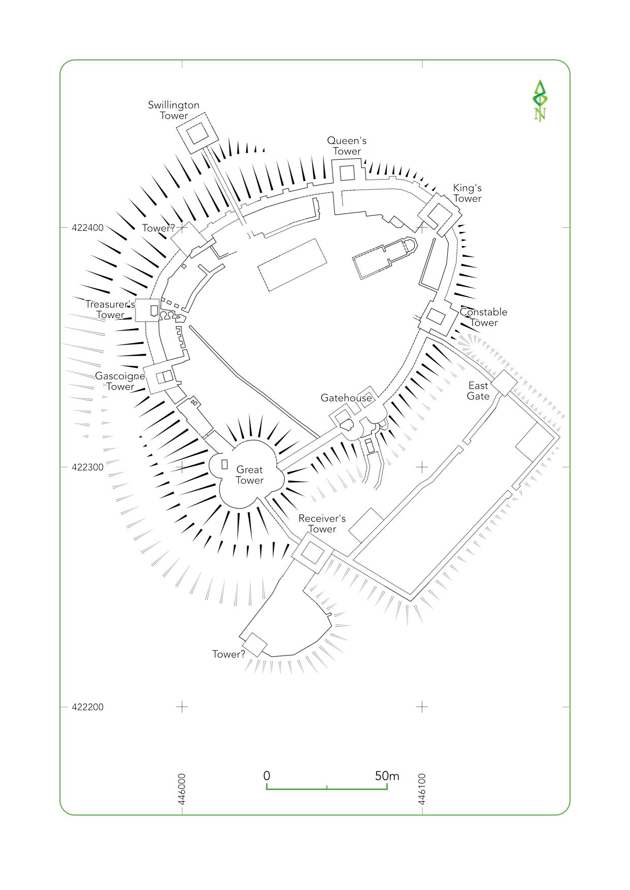
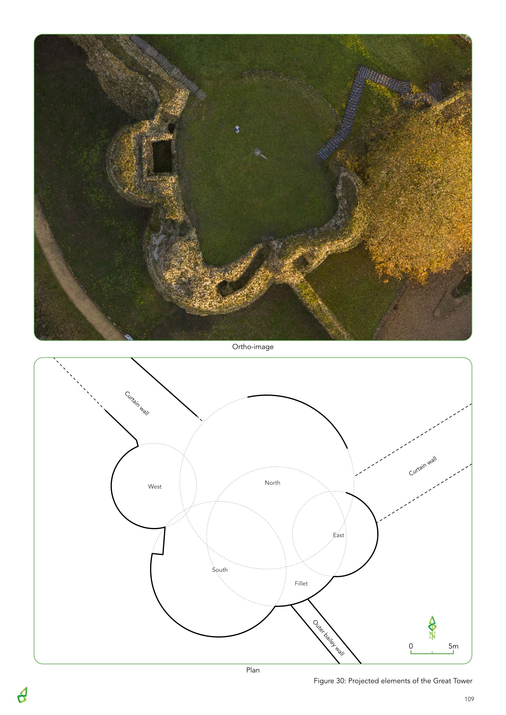
Writing in about 1530, antiquarian John Leland describes the Great Tower in 1643 as '…being cast into 6 roundelles, 3 bigge and 3 smaull…' (Roberts 2002 19), suggesting that one of the towers was lost during its demolition. It is speculated that this lost tower may have been a mirror of the small fillet tower on the opposite side of the eastern tower, thus creating symmetry across the entire structure (Roberts 2002 25). However, this interpretation relies on the fact that the north tower mirrored the southern one, which the aerial survey clearly shows it does not. An inspection of the c. 1560 survey drawing of the Castle reveals that two towers were visible between the inner bailey wall and the curtain wall, with one in the inner bailey and one outside. This is corroborated by the remains currently exposed and do not account for another fillet tower. If indeed there was another tower, it can be conjectured that had a sixth tower existed it may have been positioned between the north and east towers to distribute the towers evenly around the building.
It is widely accepted that the Great Tower was initially constructed in the late 11th century from timber, positioned on the motte of the early Norman castle. Diagnostic architectural remains of the 12th century stone castle defences are scarce but can be found in the south-west curtain wall near the sallyport, where limestone was the principal building material (Roberts 2002 405). From the beginning of the 12th century, masonry fortifications began to be added to a number of mottes previously surmounted by a timber tower. In almost all cases the stone walls encircling the summit of the mound took the form of a 'shell keep', such as at Arundel and Lincoln (Goodall 2011 107). Owing to its size and position a case can be made for the larger northern tower existing as such a structure, therefore representing the Great Tower's earliest phase of masonry construction. The curtain walls extended to the north-east and north-west from it, with additional towers added later. The position of both the east and west towers – rather than conforming to any form of symmetry – served to fortify the points in the defences where the curtain wall met the original tower. The addition of the larger southern tower may well be contemporary with these flanking towers, all of which may have been built as late as the 14th century.
Aerial survey of the castle provided information regarding the possible construction sequence of the Great Tower. Interpretation of this enigmatic feature remains tentative but further research into the nature of the northern tower base – and comparisons between it and the external elevations of the better surviving parts of the structure – may reveal the origins of the earliest stone structure on the motte.
The earliest remains recorded during excavation were the poorly preserved casing wall found within the drawbridge pit. It is believed this feature was illustrated in the 16th-century drawing of the castle extending to the north-east of the gatehouse and creating a front for the cliff face. This wall was constructed before the gatehouse, although how much before remains unclear. Sandstone was quarried from the moat in the 14th century to facilitate the construction of the Great Tower and renovations in other parts of the castle, but the poor preservation of the wall suggests it had been exposed to the elements for a significantly longer period than these works. Further investigation to the east of the passage barbican may give an insight into the extent of the masonry and how it might have functioned in relation to the earliest phase of gatehouse structure.
The centrepiece of the excavation was undoubtedly the drawbridge pit within a passage barbican bridge. Although work within the pit provided information about its date and use, many things remain unknown. The dimensions of the drawbridge pit are known but those of the larger bridging structure it was part of are not. Within the trench the side of the bridge appeared straight; however, the 16th-century drawing illustrates the structure turning towards the West Gate. This early survey of the castle proved to be remarkably accurate when compared to the remains encountered in the excavation. Therefore, it seems reasonable to assume that the bridge did indeed turn, but if so, how would this allow space enough to accommodate a drawbridge within the upper outer bailey?
Much of the visible above-ground masonry should now be considered reconstruction from the 19th century. As such, the true location of the 14th-century western gatehouse tower is still not known; however, its addition to Greaves's plan from the 1880s suggests the base of it had survived demolition. Also depicted on this archaeological plan of the castle were two semi-circular features in front of the two large gatehouse towers, interpreted as Civil War fortifications. The edge of the eastern feature was found abutting the tower; however, no evidence was found for the second. If one had existed, its remains would have been expected within the excavated area overlying the western side of the passage barbican. It may be that the feature lay outside the limits of the excavation, or possibly that it was removed as part of the Victorian landscaping of the castle.
The community excavation has greatly increased our understanding of how the Pontefract Castle gatehouse developed, and has raised awareness of Pontefract's greatest heritage asset through a targeted programme of public engagement. In achieving the aims and objectives outlined above, this project demonstrates the potential of archaeological investigation and landscape analysis to draw new conclusions about the Castle, its construction and use, as well as posing new questions.
We would like to offer a sincere thank you to Historic England, in particular Neil Redfern and Andy Hammon, for the support and enthusiasm given throughout the project, to Merrill Diplock, Angela Routledge, Ian Downes and the entire team at Wakefield Metropolitan District Council, Jenni Butterworth from Drakon Heritage and Conservation, Ian Sanderson from West Yorkshire Archaeology Advisory Services, and huge thanks also to all the staff and volunteers at Pontefract Castle. The project was managed for DigVentures by Brendon Wilkins, with Lisa Westcott Wilkins in the role of Project Executive, with post excavation managed by Joshua Hogue and Manda Forster. The site team comprised Chris Casswell, Nat Jackson, Maggie Eno, Indie Jago, Ben Swain, Harriet Tatton, Johanna Ungemach, David Wallace and Billy Watson. Adam Stanford, Aerial-Cam, undertook the aerial survey. We would also like to extend our thanks and gratitude to all specialists that have been involved in the project; Karen Barker, Chris Cumberpatch, Elizabeth Foulds, Gerry McDonnell, Hannah Russ, Carl Savage, Ruth Shaffrey, and Ellen Simmons. Elizabeth Foulds also provided the artefact illustrations.
The project would not have been possible without our community of Venturers, so huge thanks go to: Joanne Harrison, Elizabeth Harrison, Marc Harrison, Catherine Harrison, Yvette Sheldon, Keelan Boggs, Tina Firthlock, Jack Firthlock, Tilly Firthlock, Sarah Conway, Grace Conway, Steve Howell, Lindsay Howell, Neve Howell, Mia Pickard, Ava Pickard, Scarlett Pickard, Joanne Pratt, Amelia Pratt, Joshua Pratt, Craig Pratt, Josephine Acker, Kristina Acker, Angela Gilbert, Emily Gilbert, Martha Gilbert, Mark Gilbert, Autumn Wray, Ellen Wray, Megan Carnell, Paul Stirling, Sonya Carnell, Val Rowe, Ella Gummow, Oliver Gummow, Alexa Gummow, Alistair Gummow, Christina Riley, Freya Storier, Emma Hudson, Fraser Hudson, Jennifer Lane-Price, Rosie Price, Philip Lofthouse-Burch, Alexander Lofthouse-Burch, Sebastian Lofthouse-Burch, David Robinson, Lizzie Robinson, Kinga Wisniewska, Paul Pickering, Joanne Clarida, Karen Bielby, Amber Carpenter, Diane Gourley, Andrew Benbow, Andy Heath, Helen Alexander, Ben Alexander, Lucy Alexander, Linda Johnson, Roy Johnson, Ian Featherstone, Christine Featherstone, David Pickersgill, Abbie Morley, Ann Mccall, Barbara Adelaide, Brian Thomas, Michelle Leboutte, Caroline Baxter, Noah Baxter, Catherine Archer, Derrick Archer, Chris Brennan, Christopher Ward, Clare Pritchett, Davina Omar, Emily Murphy, Gaynor Thomas, Gemma Murphy, Hannah O'Toole, Stephen Peasent, Darren Pass, Peter Birkby, Brian Ward, Jacqui Ratcliffe, Ian Roberts, Isabella Murphy, Jacqueline Awan, Jamie Maddison, Joanna Henderson, Joanne Murphy, John Sweetman, Kathryn Rose, Kurt Colyn, Lee Reid, Lizzy Moyce, Louise Spurr, Mark Braham, Mary Knight, Natasha Awan, Olivia Carrington, Rosie O'Toole, Ruth Matuska, Ryan Barraclough, Ryan Candler, sarah boyle, Thomas Hayman, Thourayya Adelaide, Tom Willis, Sarah Day, Richard Noakes, Phoebe Day, Charlie Noakes, Michelle Hadcroft, Christopher Craven, Sophie Craven, Jessica Craven, Kevin Smith, Richard Booth, Alexander Booth, Alison Richards, Gareth Hare, Megan Hare, Emma Brown, Savannah Brown, Mali Evans, Nia Evans, Emma Evans, Andrew Evans, Leeanne Mckenzie-Taylor, Eric McKenzie, Jessica Mckenzie-Taylor, Laura Horton, Lily Horton, George Jones, David Jones, Karen Hamlet, Jack Ellis, Charlie Ellis, Diane Ellis, Jeffrey Pickering, Barbara Pickering, Evelyn Tomlinson, Carly Booker, Steven Booker, Erin Booker, Lucy Booker, Jenni Shields, Andrea Johnson, Michael Johnson, Samuel Johnson, Max Johnson, Jessie Hamer, Robson Cutts, Samantha Blakey, Richard Blakey, Charlotte Blakey, Emily Blakey, Rachael Reid, Jack Reid, Thomas Reid, Bryn Heeley, Zac McBain, David Heeley, Sophia Cattan, Helen Cattan, Simon Taylor, Edith Taylor, Gary Bryars, Isaac Bryars, Harry Wiles, Anne-Claire Bennion, Ben Bennion, Rose Bennion, Jules Bennion, Sara Fryer, Charlie Fryer, Bill Fryer, Sam Morris, Sarah Morris, Jessica Ellery, Jonathan Elleray, Linda Verney, Joanne Richardson, Sheila Masterton, Ian Masterton, Sally Dye, Kirsty Grundy, Isla Grundy, Jackie Clitheroe, Mahale Clitheroe, James Stephenson, Eva Stephenson, Gwyneth Lonergan, Samantha Foster, Benjamin Foster, Eleanor Croot, Jude Croot, Ivy Croot, Beatrix Croot, Charlie Mellor, Michael Mellor, Oliver Simpson, Rebecca Ayton, Joshua Carr, Helen Carr, Emma Salsbury, Francesca Salsbury, Lucinda Salsbury, Alexandra Round, Max Round, Ben Hare, Chris Hare, Kerry Hare, Lorna Malkin, Harry Malkin, Jack Malkin, Margaret Hindle, Lynda McCraight, Keira Hardy, Daisy Hardy, Michael Hardy, Georgia Hawkins, Will Rowley, Ben Rowley, Sam Rowley, Vicky Thew, Becky Elsey, Evie Elsey-Smith, Sofie Elsey-Smith, Carole Wilkinson, John Wilkinson, Kirsty Lunn, Nick Parker, Alison Parker, Terry Berry, Kevin O'Connell, Andrew Fisher, Jacqui Smith, Rachael Ledger, Tilly Ledger, Ted Ledger, Kevin Murray, Imogen Axworthy, Mark Axworthy, Gary Hawes, Megan Hawes, Dean Dean, John Dean, Janet McNaught, Neil Barney, Andrew Rhind, Maxine Rhind, Sarah Freck, Caroline Jowett, Isabella Jowett, Ethan Hume, Brian Hume, Ethan Greenwood, Natasha Gaddas, Oliver Creasser, Michele Smale, Chloe Taylor, Luke Jennings, Billy Watson, Jolan Mulholland, Michael Mulholland, Daisy Sullivan, Gill Sullivan, Paul Sullivan, Alfie Sullivan, Tobias Evans, Anna Evans, Ian Smith, Toby Fairhurst, Sue Fairhurst, Joe Fairhurst, Stephen Fairhurst, Ellie Coworth, Sarah Tomlinson, Annabel Foster, Hilary Hodgson, Michael Hodgson, Gavin Cave, Yasmin Syed, Carolyn Edwards, Liga Karklina, Janis Karklinus, Roger Offord, Christian Ashton, Harvey Williams, Nick Ashton, Philip Wilkinson, Richard Wilkinson, Sami Quddoos, Jessica Moore, Grace Moore, Kaya Ethan Alyanak, Kirsten Whatley-Bell, Louis Collier, Leighton Davison-Clare, Callum Norton, Younas Cheema, Chloe Hayter, Sophie Jones, Jacob Lewis, Sadie Shaw, Charlie Keenan, Eden Allison, Edward Brewer, Finley Donaldson, Imogen Brewer, George Chapman, Alfie Chapman, Oliver Keen, Toby Cade, Charlotte Jennison, Rowan Weston, Zac Weston, Toby Williams, Jasper Williams, Jessica Greenwood-Field, Charlotte Wilson, Matthew Siddall Lancaster, Keira Skeldon, Louis Kelly, Aaron Friar, Connor March, Ben Harvey-Walker, Cameron Harvey-Walker, Jamie Gate, Ailish Colling, Thomas Jackson, Emily Jackson, Joseph Curnow, Jessica Curnow, Ellen Hall, Alex Hall, Poppy Evans, Frazer Rollirp, Iona Dorsett, Sydney Wilson, Thomas Waring, Oliver Symonds, Katie Muscroft, Moss Chapman, Poppy Chapman, Kai Swell, Nathaniel Rossell and Lilly Bowden.
Internet Archaeology is an open access journal based in the Department of Archaeology, University of York. Except where otherwise noted, content from this work may be used under the terms of the Creative Commons Attribution 3.0 (CC BY) Unported licence, which permits unrestricted use, distribution, and reproduction in any medium, provided that attribution to the author(s), the title of the work, the Internet Archaeology journal and the relevant URL/DOI are given.
Terms and Conditions | Legal Statements | Privacy Policy | Cookies Policy | Citing Internet Archaeology
Internet Archaeology content is preserved for the long term with the Archaeology Data Service. Help sustain and support open access publication by donating to our Open Access Archaeology Fund.
 Home
Home