Cite this as: Kirby, M. and Walker, J. (with contributions by D. Alldritt, S. Anderson, A. Clarke, D. Griffiths, C. Hills, F. Hunter, J. Thoms, K. Hartley and F. Wild) 2023 The Excavation of a Romano-British Site at Netherhall Road, Maryport, Internet Archaeology 61. https://doi.org/10.11141/ia.61.7
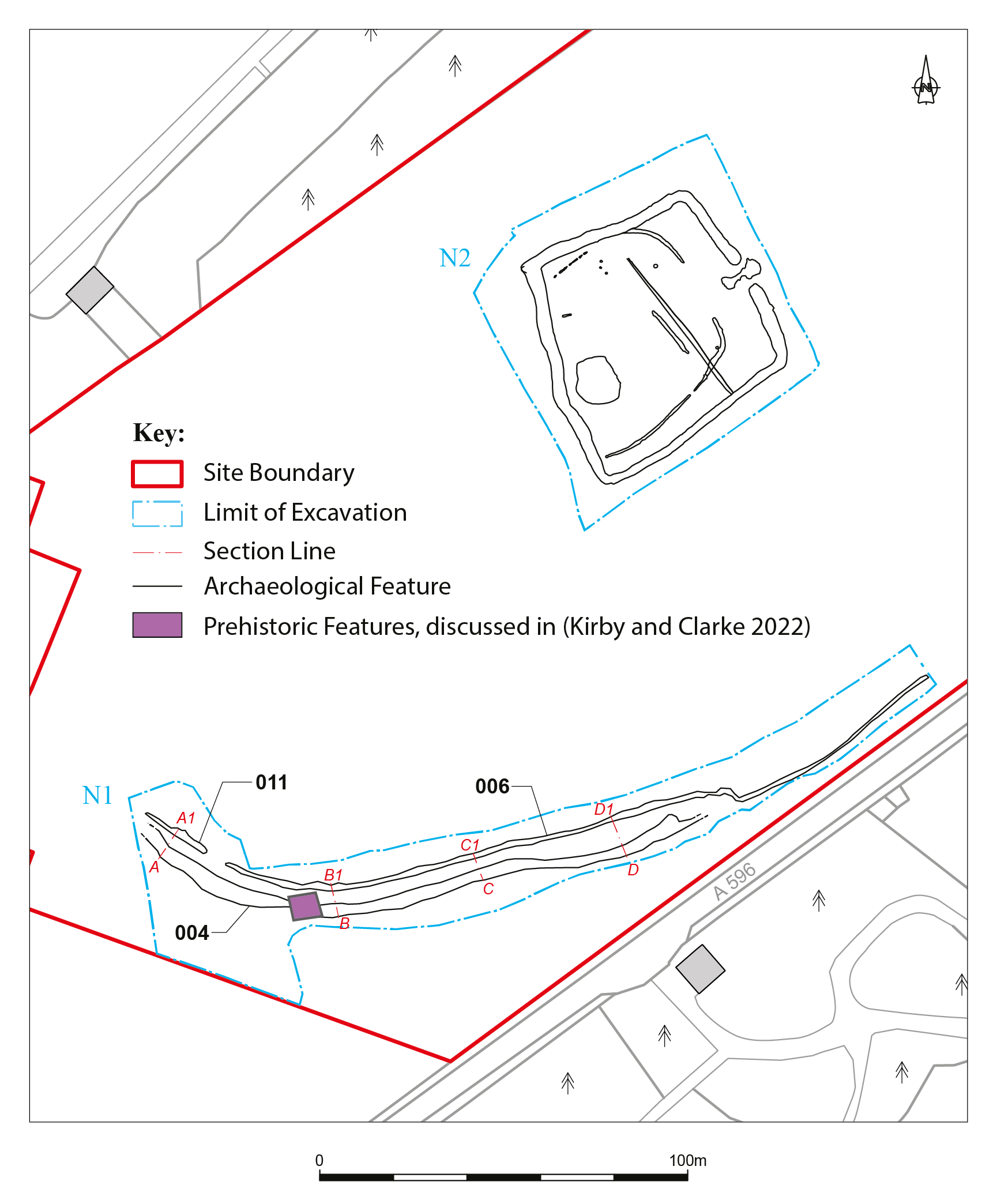
In April 2010, CFA Archaeology Ltd was commissioned by Story Homes Ltd to carry out a programme of archaeological trial trenching within an area of land that lies between Maryport (Alavna) Roman Fort and Netherhall Road on the north-eastern outskirts of Maryport (NY 0406 3692) (Figure 1). This area had previously been the subject of a geophysical survey conducted as part of a large-scale research survey of Roman Maryport undertaken by TimeScape Surveys (Biggins and Taylor 2004). The geophysical survey identified a number of anomalies of archaeological potential, which were targeted during the 2010 programme of works (Kirby 2011). This evaluation confirmed the presence of a large ditched enclosure and two parallel linear features (later interpreted as a track and parallel drainage ditch). It also targeted a linear feature thought to be the line of a Roman road. Definitive evidence of the Roman road was not identified, but a Roman-period cremation cemetery was uncovered adjacent to the assumed line of the road. A further programme of trial trenching and geophysical survey was undertaken in 2011 (Kirby et al. 2011; Tanner 2011), targeting the inside of the enclosure prior to a full programme of excavation being agreed with Cumbria County Council Historic Environment Service (CCCHES) and English Heritage.
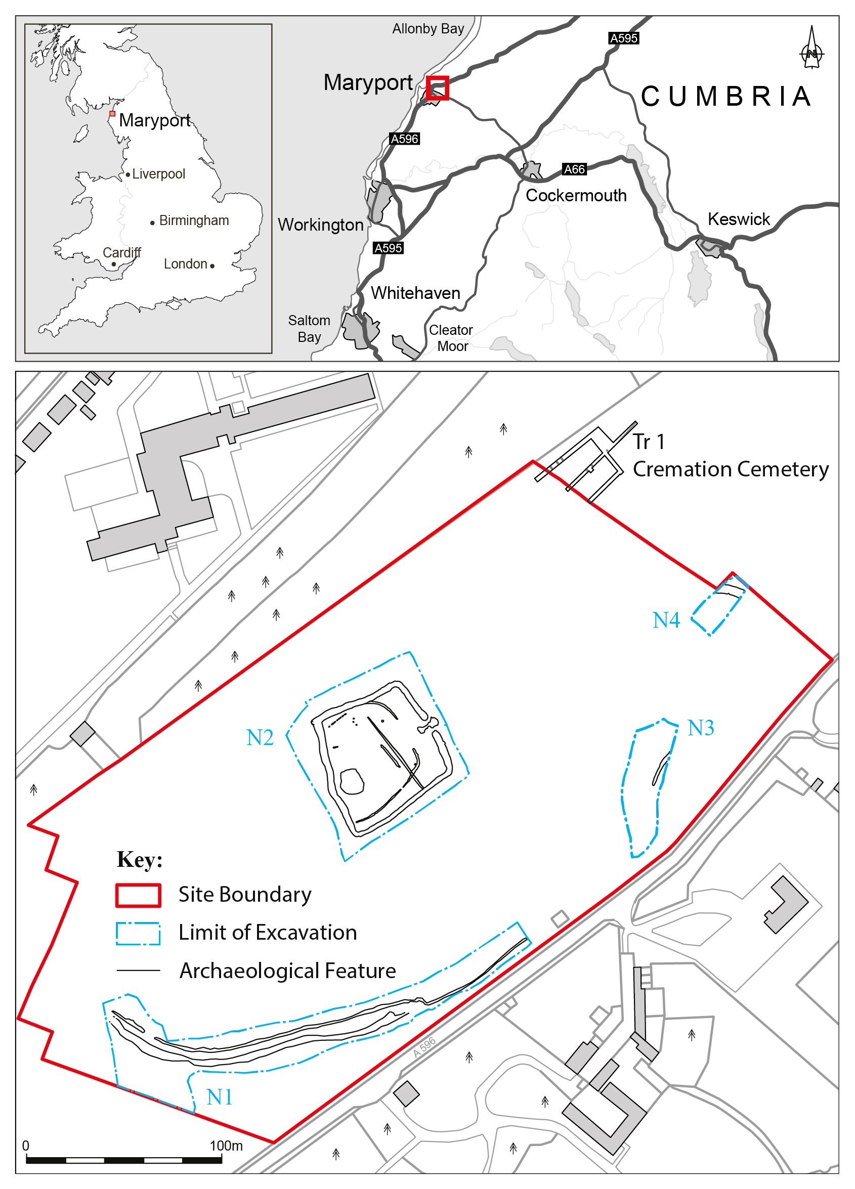
The excavation was undertaken in two phases, with an initial phase between December 2014 and March 2015 and a second phase in May 2016, and targeted the ditched enclosure, the track and parallel drainage ditch, and a possible spur linking the putative Roman road leading to the fort with the enclosure (Figure 1). Although the majority of the features excavated are considered to represent rural Romano-British settlement, their close proximity to Maryport (Alavna or Alauna) Roman Fort and its associated vicus suggest that they should be viewed within the wider context of Roman occupation and settlement. The site’s physical archive will be offered first to Senhouse Museum at Maryport, and then to Tullie House, Carlisle. A digital archive will be submitted to ADS.
The significance of Maryport during the Roman period stems from its position forming part of the Roman frontier defences along the Cumbrian coast. These defences extended from Ravensglass (Glannoventa) Roman Fort in the south to Bowness-on-Solway (Maia) Roman Fort in the north. This series of fortifications was part of the same frontier as Hadrian's Wall and was designed to control access across the Solway. The construction of these fortifications was broadly contemporary with the wall, placing them around 120 CE.
Maryport Roman Fort itself sits on a low sandstone ridge at an altitude of c. 50m aOD, from which there are extensive views across the Solway Firth towards south-western Scotland. Evidence of a substantial vicus (civilian settlement) associated with the fort was identified as early as the 16th century when the then landowner John Senhouse carried out a series of limited excavations, primarily for the recovery of carved inscriptions and sculptures. These inscriptions and sculptures formed the beginning of the Netherhall collection, which was later to become the largest private collection of Roman antiquities from any single site in the British Isles (Bailey 1915).
The Senhouse family continued excavations on the fort and vicus throughout much of the following three centuries with the twin aims of recovering Roman antiquities and salvaging building materials to reuse in the expanding town of Maryport. One of the most notable discoveries was made in 1870 when 17 altar stones were recovered and these, along with other inscribed stones, provided evidence that the regiments stationed there originated from as far away as Spain, Dalmatia (part of Croatia), and what is now the Netherlands (First Cohort of Spaniards, First Cohort of Dalmatians, and First Cohort of Baetasians respectively). However, as Breeze (2018) points out, the origins of these units would not have reflected the origin of the soldiers based at Maryport, with troops being recruited both locally and from other parts of the Roman Empire such as Gaul and Germania.
In 1880 more extensive remains were identified by Joseph Robinson, who uncovered numerous strip houses located alongside a Roman road running from the north gate of the fort through the vicus. Robinson also uncovered a Roman temple, which was re-excavated by Newcastle University in 2013 (Haynes and Wilmott 2014). This temple is the north-westernmost classical temple known from the Roman world, reflecting the importance of Maryport during the Roman period. The increasing use of aerial photography in the 20th century provided additional evidence of the extent of the vicus, with further and more detailed evidence coming from the geophysical survey undertaken by TimeScape Surveys in 2004.
The area investigated during this programme of works lay outside the main area of the vicus, c. 200m to the south-east of the Roman fort. It was situated opposite Netherhall Mansion (former home of the Senhouses of Maryport) immediately to the north of the A596. Topographically, the area sloped steeply upwards in a south-east to north-west direction from the edge of the A596 before levelling out into a series of undulating gullies and plateaux (Figure 2). The area is understood to have formerly been a deer park associated with the Senhouse Estate and was depicted on the First Edition Ordnance Survey map as containing a number of areas of woodland. These trees appear to have been cleared during the 20th century and the land subsequently utilised for pasture until the present day. The surviving part of Netherhall Mansion is a 14th-century Peel Tower, possibly suggesting that the deer park may have had medieval origins. Information obtained from a local resident suggested that an episode of landscaping was undertaken during the 1960s with some of the deeper gullies being infilled using a bulldozer, but the evidence from the evaluation undertaken by CFA in 2010 (Kirby 2011) suggested that this work was fairly localised and had minimal impact on the area as a whole. Aside from the aforementioned works, modern intervention within the area appears to have been minimal, and consequently the surviving archaeological features are considered unlikely to have suffered extensive damage through events such as plough truncation.
Four areas were selected for open area excavation following the evaluations (Figure 1). These consisted of an area containing two parallel linear features (ditch and track) (Area N1), an area containing the sub-square ditched enclosure (Area N2), an area containing a possible continuation of the ditch and track seen in Area N1 (Area N3), and an area containing a possible south-west spur of a putative Roman road leading to Alavna Roman Fort (Area N4). The area containing the Roman-period cremation cemetery lay outside the proposed development and the decision was taken in consultation with CCCHES and Historic England that it should be preserved in situ, so no further work beyond that undertaken during the evaluation took place here.
The trial trenching targeting the line of the putative Roman road led to the identification of a previously unrecorded Roman-period cremation cemetery situated on a low flat-topped knoll. This was initially identified following the discovery of a shallow pit (022) containing sherds of a Rhenish beaker with barbotine decoration; the vessel contained the remains of a child of no more than 12 months old and dated to the second half of the 3rd century. The pit was 0.5m in diameter and 0.1m deep.
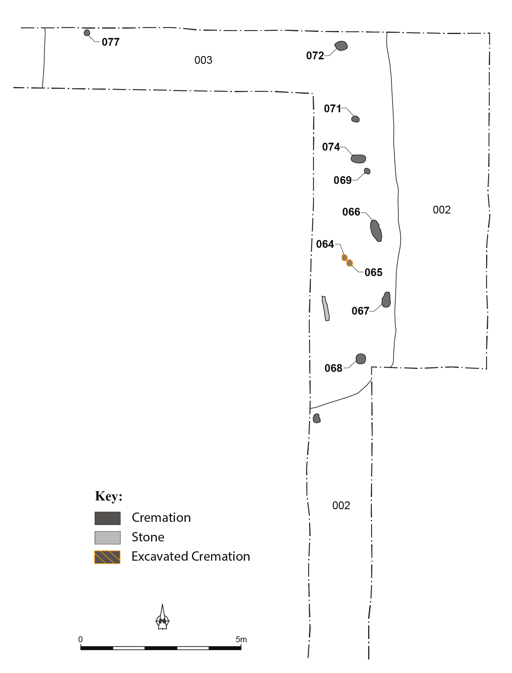
Two further trenches were excavated to determine the full extent of the cemetery. This led to the discovery of a further nine possible cremations (064/065, 066, 067, 068, 069, 070, 071, 072 and 073) and the base of an upright stone (074), possibly a marker stone (Figure 3).
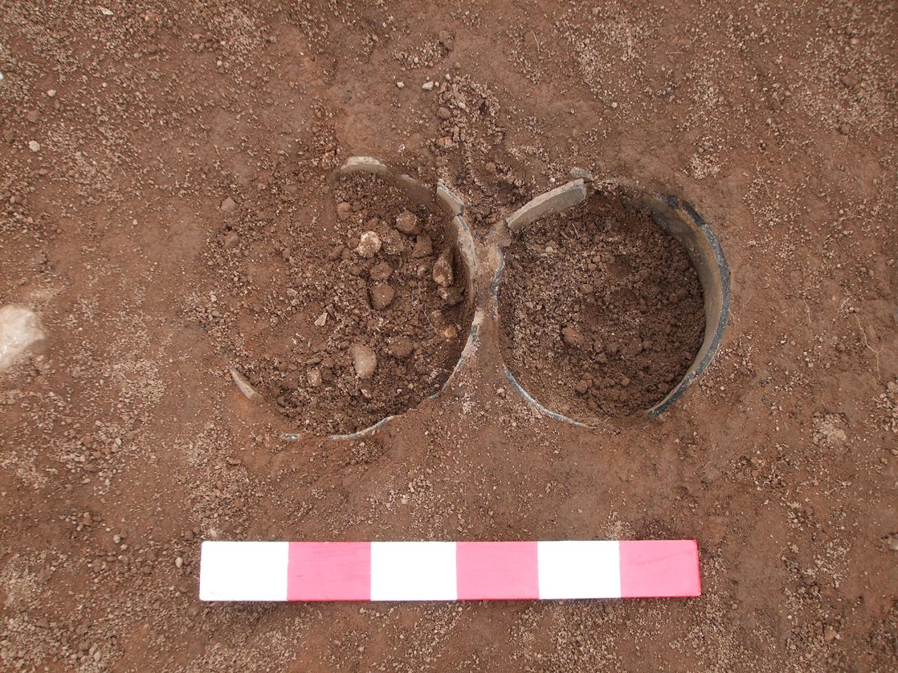
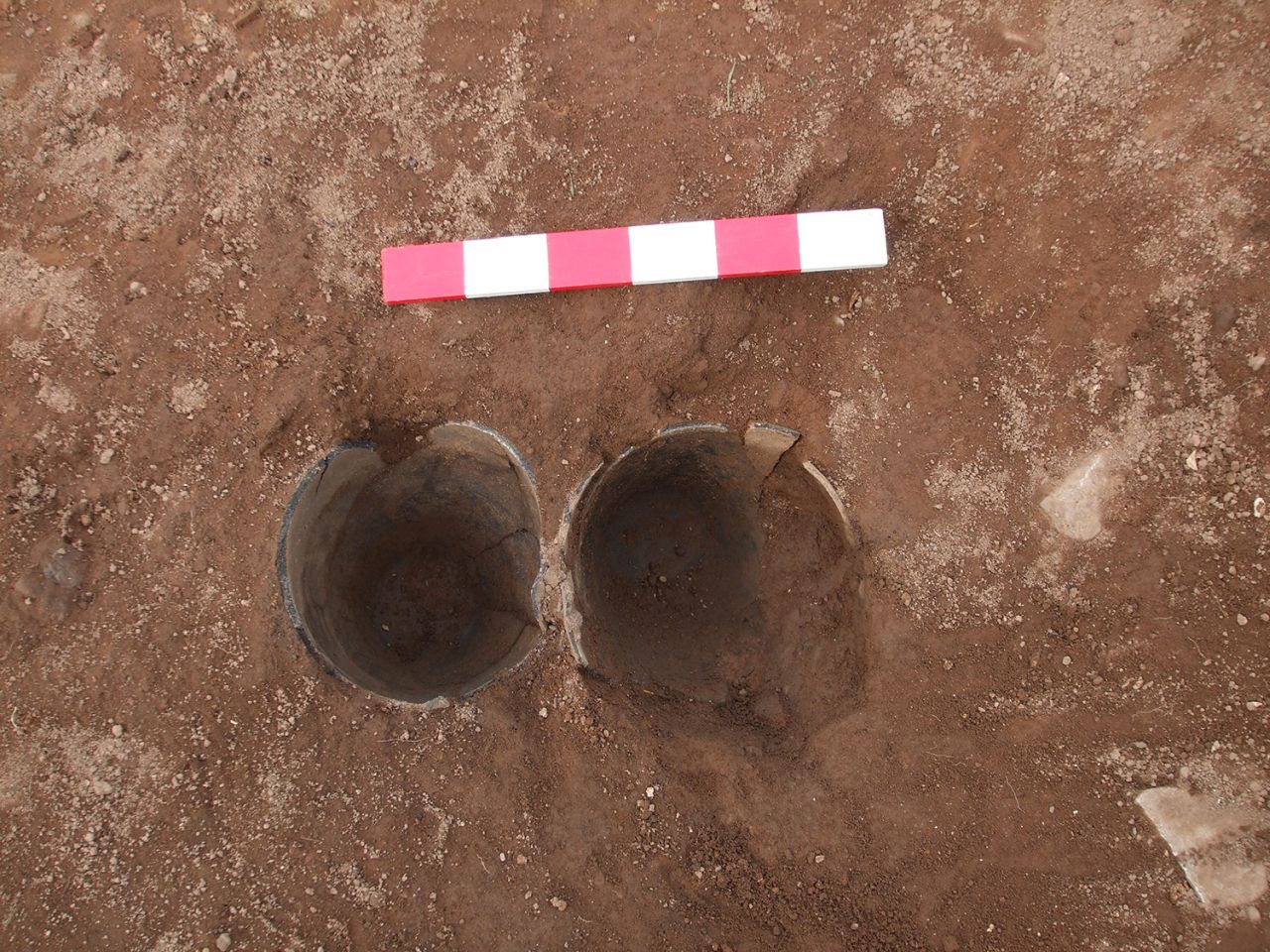
One of the cremations (064/065) was fully excavated (Figure 4, Figure 5). It consisted of two ceramic vessels, both black-burnished ware jars of mid-3rd century or later date, one of which contained the cremated remains of a mature adult female, along with hobnails, an iron brooch, and iron nails, copper-alloy studs and sheet heads that could be the fittings from a box or container. A cut for the insertion of these vessels was not identified, possibly indicating that it had been back-filled straight away. A sample of bone submitted for radiocarbon dating produced a date of 90 to 245 CE at 95% probability (SUERC-88676).
Most of the remaining cremations (066–072), consisted of dark patches in the subsoil (003) measuring up to 0.7m by 0.3m, with evidence of cremated bone and pottery on the surface. One (073) consisted of the base of an upturned pottery vessel. These features were preserved in situ.
The track (004) and parallel drainage ditch (006/011) were located within the south-western part of the development area (Figure 6). Topographically, this area predominantly consisted of a very steep embankment with a gradient of up to 30%, which sloped upwards from south-east to north-west. This very steep gradient had resulted in a considerable accumulation of colluvial/slopewash deposits (002) forming, with up to 1.5m of deposits (topsoil and slopewash) sealing the track and ditch at the base of the break of slope. The material (003) underlying the colluvial deposits into which the track and ditch had been cut consisted of fairly well-consolidated reddish-brown sand and gravel. These colluvial deposits were found to be sealing an area of early prehistoric activity, which is the subject of a separate publication (Clarke and Kirby 2022).
The track (004) was visible as a shallow east to west aligned slopewash-filled depression traversing the face of the hillside. It was identified extending over a distance of c. 125m and had a width of up to 4.2m. Fifteen sections recorded through this feature demonstrated that it had been benched into the hillside in order to create a level path on which to walk. The fill of this feature largely consisted of orange-brown silty-sand slopewash deposits.
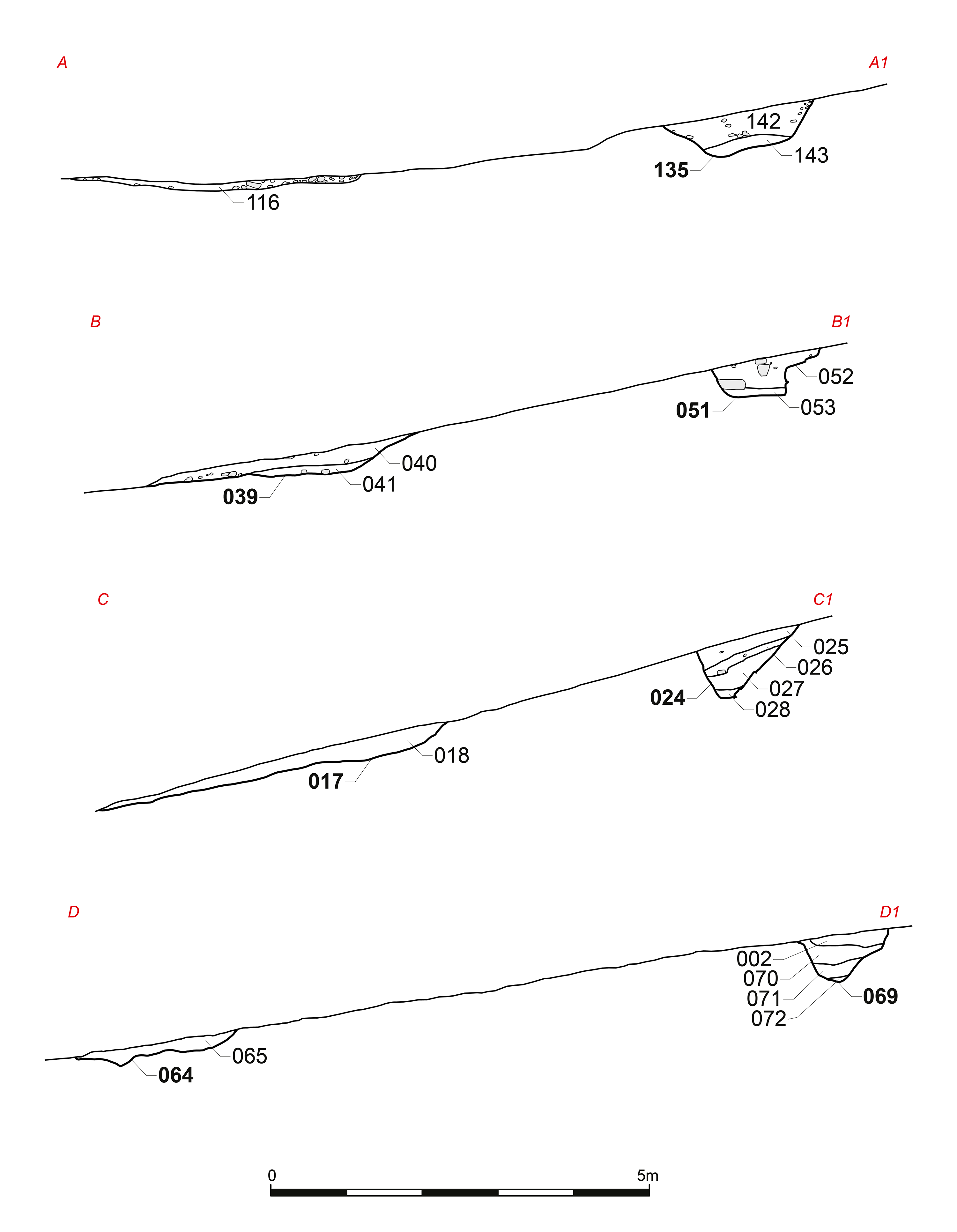
The parallel ditch (006) was situated on the upslope side at a distance varying between 3m and 7.4m and appears to have been positioned to divert water-runoff from the hillside away from the track. A c. 200m length of this feature was uncovered, with it running from a shallow terminus at its western end down to the eastern extent of the stripped area where it continued beneath the trench section. Although the alignment of the ditch was broadly west to east, there was one point towards the eastern end of the trench where it turned a dogleg before resuming its original course. It is thought that this was done in order to avoid an outcrop of bedrock at this point.
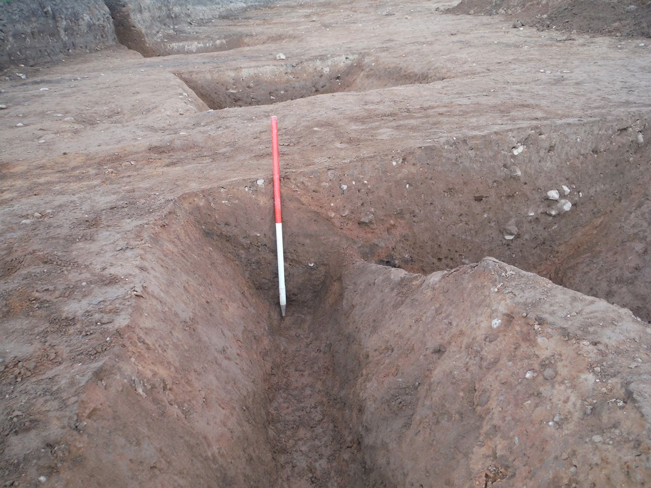
Twenty-seven sections recorded across ditch 006/011 showed that it had a width varying between 2.1m and 0.6m, and a depth varying between 0.4m and 0.84m (Figure 7, Figure 8, Figure 9). This ditch generally had a comparatively gently sloping northern profile on the upslope side (probably eroded by water-runoff) whereas the profile on the downslope southern side was generally considerably sharper. The base of the ditch tended to be either rather flat or rounded, while the fill of this feature consisted of layers of sandy gravel, which had clearly been washed in from the upslope side. Radiocarbon dates on paired samples of charred barley (Hordeum sp.) recovered from the lower fill of ditch 006 (072) produced dates of 165 BCE to 20 CE and 100 BCE to 20 CE at 95% probability (SUERC-88693, SUERC-88694; Table 1).
Beyond the western terminal of Ditch 006/there was a c. 6m gap before the beginning of a north-westward extension of this feature (011). It was exposed for a distance of c. 25m, with it continuing outwith the north-western corner of the trench beneath the section. Three sections recorded through this portion of the ditch showed that it had a width varying between 2m and 1.3m and a depth of between 0.32m and 0.64m.
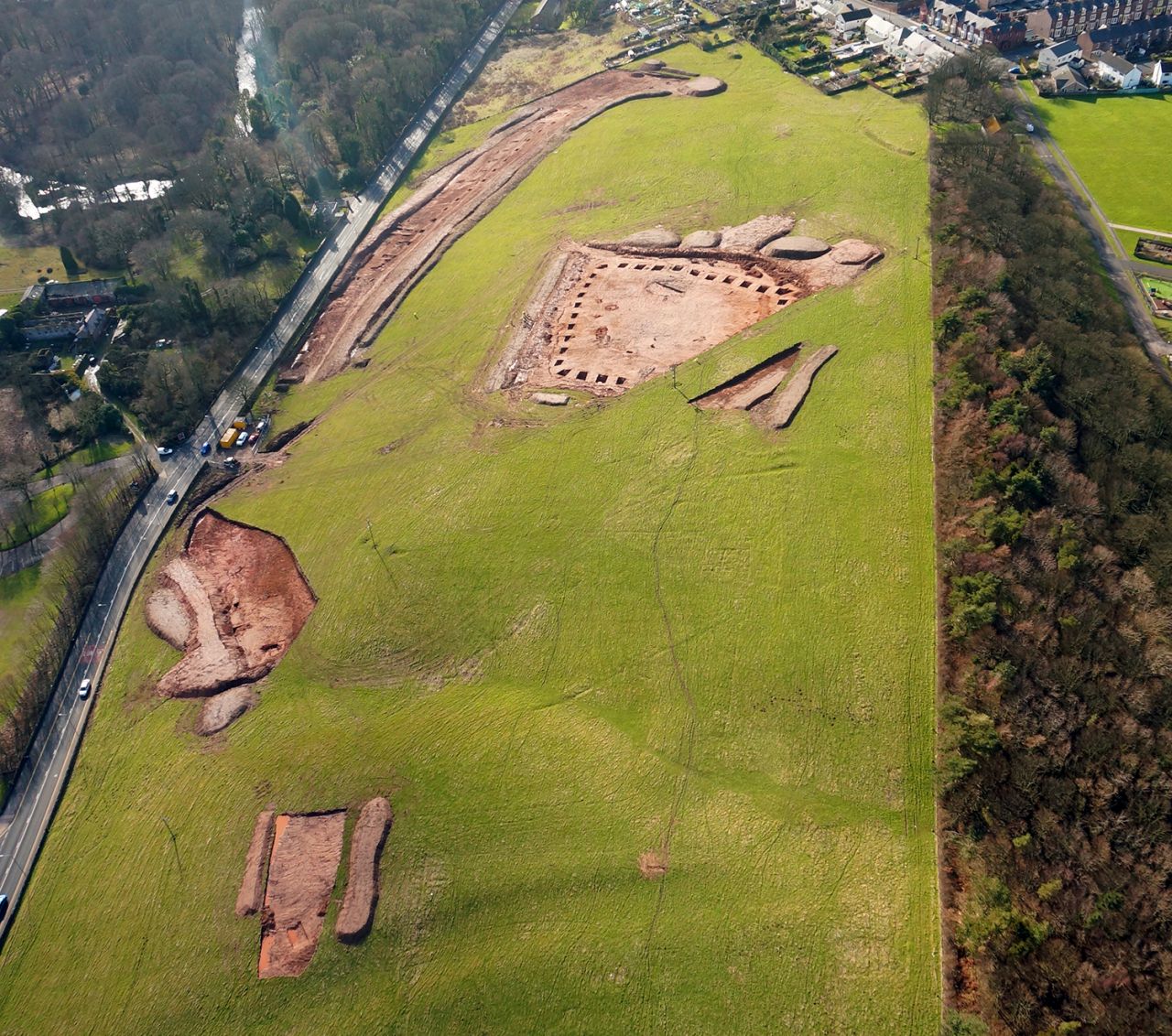
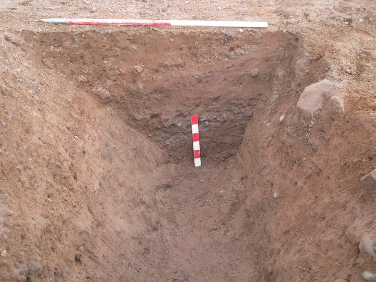
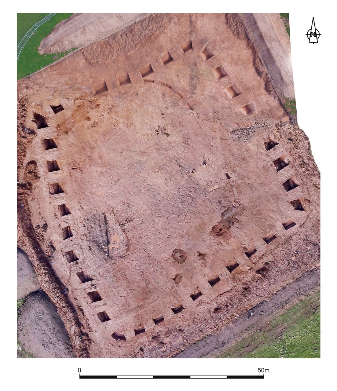
The sub-square enclosure (200) was situated towards the centre of the development area, occupying reasonably level ground at the top of the steep embankment leading up from the A595 (Figure 10, Figure 11). This area sloped gently downwards from north-west to south-east, with the gradient becoming considerably more pronounced towards its south-eastern end. At the north-western end deposits up to 1.2m thick were sealing the remains of the enclosure, which thinned to around 0.4m at the eastern end. The excavation demonstrated that there were two phases of enclosure.
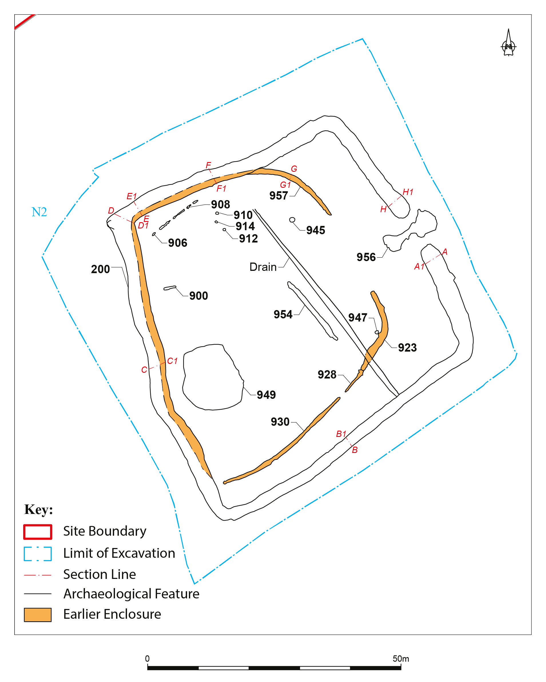
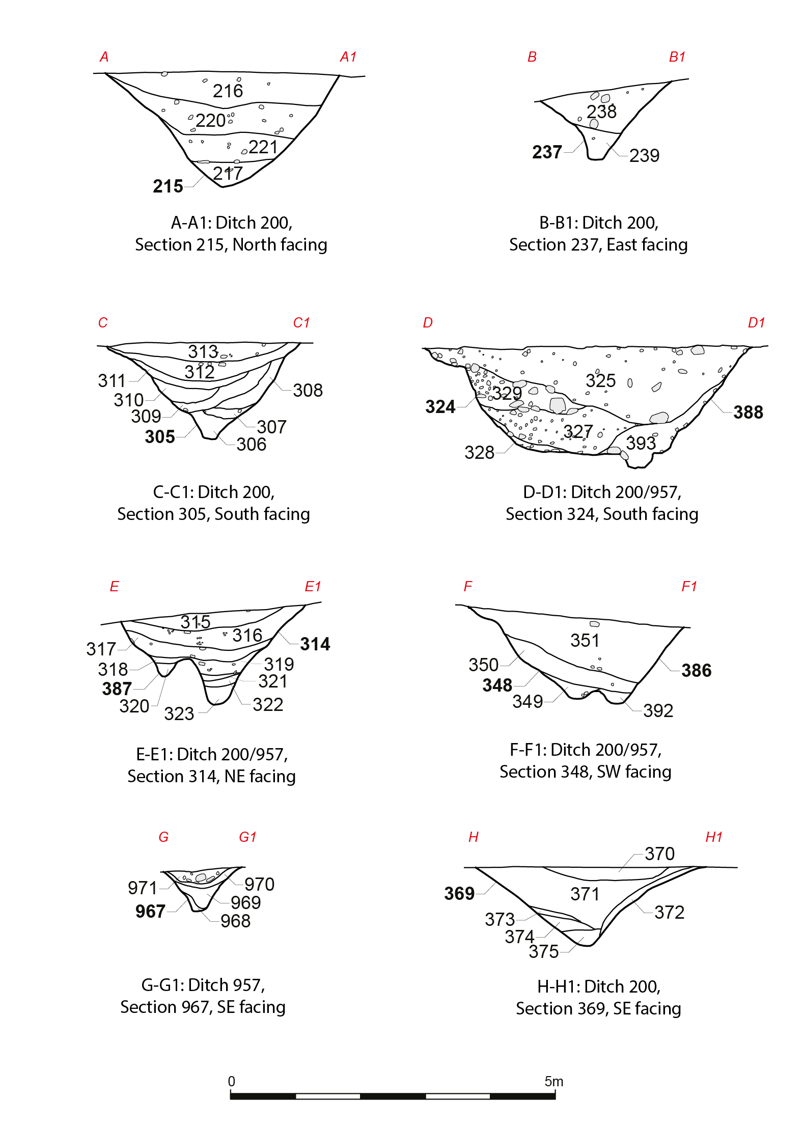
During the course of the excavation, it was identified that Enclosure 200 cut an earlier D-shaped enclosure, which was partially on the same footprint, represented by linear features 923, 928, 930 and 957. This earlier enclosure measured 57m north-west to south-east by 50m north-east to south-west. Ditch 957 formed the northern, western and part of the eastern edge of this enclosure, and was visible running below the later enclosure. It originated close to the centre of the northern side of Enclosure 200 and then followed the alignment of Enclosure 200 to approximately the south-western corner. This ditch (957) had a V- or U-shaped profile. Clear evidence was obtained where Ditches 957 and 200 converged (Figure 12, Figure 17) that the former had been cut by the latter, demonstrating that it was the earlier of the two features.
The part of Ditch 957 within the interior of the main enclosure started as a very shallow gully with a width of 0.2m and a depth of 0.2m, gradually increasing in size to measure 1.1m wide by 0.62m deep where it converged with the main enclosure ditch. It then continued to deepen to a maximum depth of c. 1.8m where it followed the alignment of the main enclosure, showing up as a second channel at the base of the excavated sections (section cuts 385-391; Figure 12); in some sections, the two channels were clearly divided by a significant ridge of natural, but within the remaining sections the bases came close to converging with only a low rounded ridge between the two channels. Ditch 957 was not identified within some sections excavated along the western side of Enclosure 200, indicating that the excavation of the main enclosure ditch had removed all trace of it.
The two ditches (923/928 and 930) forming the southern and a small part of the eastern edge of the earlier enclosure were on a much smaller scale. Ditch 930 ran in an easterly direction from close to the edge of Enclosure 200 for a distance of c. 28.5m before terminating. This ditch measured up to 0.8m in width by 0.26m in depth, and had sloping sides and a flat base.
Ditch 923 was on the same alignment as Ditch 930 and ran for a distance of c. 18m. It had a width of up to 1m and a depth of up to 0.5m, with a profile that varied between V- and U-shaped. A terminus at the northern end of Ditch 923 indicates that the intended entrance into this enclosure was at its north-eastern end, more or less in line with that of the main enclosure. Very slight traces of a further linear feature (928) were identified running from the south-west terminus of Ditch 923, petering out after 5m close to the eastern terminus of Ditch 930.
The later enclosure (200) was sub-square, measuring 64m across externally and c. 57m across internally, giving it an enclosed area of c. 3250m² (Figure 11). It had an entrance 7.5m in width in the north-eastern side. Thirty-four slots, each measuring c. 3m in length, were excavated through the ditch (Figure 12). The excavated sections showed that the ditch had a maximum width of c. 5m at the north-western corner, reducing to as little as 2m along the south-eastern edge. There were also considerable variations in the depth of the ditch, with a maximum of 1.9m recorded in the north-western corner and 0.8m recorded in the south-western corner (Figure 13, Figure 14, Figure 15, Figure 16). This large variation in depth and width may be a reflection on how it was originally dug, but with the south-eastern edge being situated on much more steeply sloping ground, this part of the site is likely to have been subjected to a higher degree of erosion. It was also of note that the inside of the south-eastern edge had a considerably more shallow profile than the outside edge, possibly reflecting a greater degree of damage from water runoff.
The morphology of the ditch also showed a considerable degree of variation, ranging from a steep-sided V-shape through to a much broader based U-shape. Parts of the northern and western edges of the enclosure had been cut along the alignment of the earlier ditch (957) (Figure 17).
The fills of the ditch predominantly consisted of silty sands, which are likely to have started to accumulate soon after the ditch was excavated. At the base of the ditch these deposits tended to be considerably more gravelly, with numerous small stones present. Considerable variations were noted between the recorded sections, with some containing only a single fill while others contained up to eight fills. However, on the whole the variations between the recorded contexts tended to be fairly slight with only subtle differences noted, and are considered most likely to simply represent material getting washed in to the ditch rather than deliberate backfilling.
Radiocarbon dates taken on a paired sample of charred barley (Hordeum sp.) and hazel charcoal (Corylus sp.) charcoal produced dates of 50 BCE to 55 CE (SUERC-88695) and 365 to 200 BCE (SUERC-88696) respectively at 95% probability. A number of pottery sherds were recovered from this ditch, with the majority of them coming from the upper fills. These ranged in date between the 1st and 4th centuries CE, suggesting a build-up of material prior to the ditch filling up. A sherd of pottery from the primary fill of the ditch was dated to the 2nd century (110-180 CE).
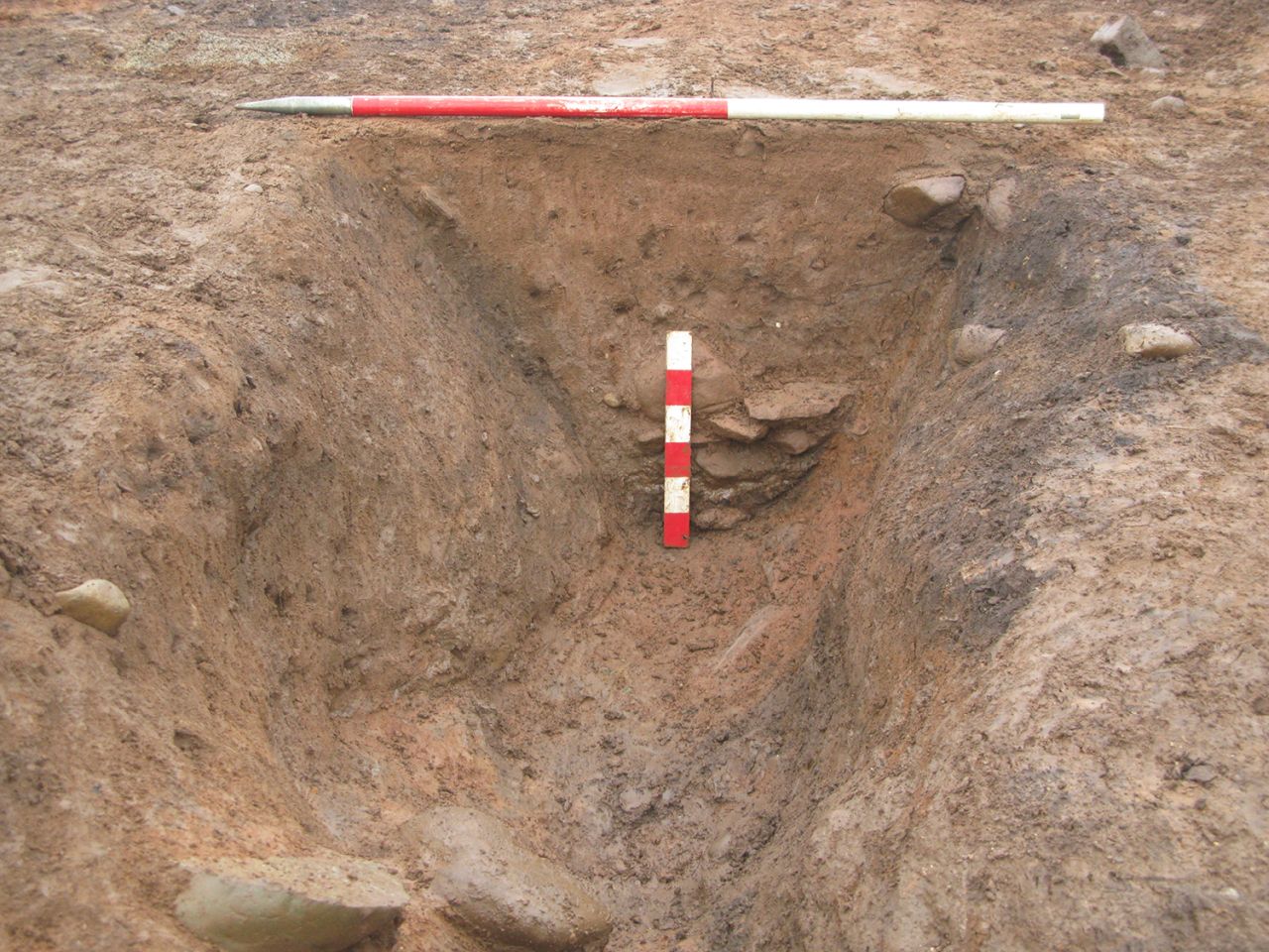
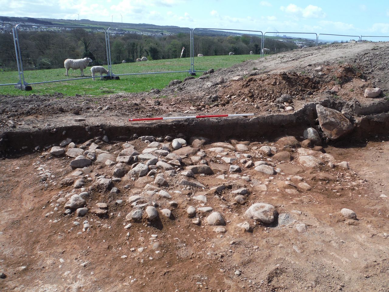
Cut into the outer edge of the ditch, to the south of the southern entrance terminus, there was a shallow pit. The base of the pit had been lined with flat sandstone slabs (384). This flagstone lining measured c. 1.7m north-west to south-east by 1.5m south-west to north-east and had been edged by low sandstone uprights. The western edge of this surface appeared to have been cut by the ditch, suggesting that it may have pre-dated the enclosure. A further small area of flagstones was identified in the north-western corner of the enclosure ditch, but it overlay the fill of the ditch, indicating that it was a later feature.
A sub-circular feature (346) was identified in the base of the ditch just to the east of centre on the northern side of the enclosure. The feature was around 0.25m in diameter and had a depth of 0.12m. The fill 347 comprised heavily waterlogged mid-brown clayey sand.
A limited number of internal features were identified. These consisted of a stone surface (956), a large sub-circular hollow (949), five pits (910, 912, 914, 945 and 947), and three linear features (900, 906 and 954).
Surface 956 was located within the entrance to the main enclosure (Figure 18). It had an irregular tapered shape, narrowing in the middle and widening out at either end. Overall, it measured c. 10m south-west to north-east and up to 4.5m north-west to south-east, narrowing down to c. 1m in the middle. The surface had been constructed from rounded and angular stones measuring up to 0.5m in length capped with a layer of fairly fine gravel. Its purpose is unclear.
Feature 949 consisted of a sub-circular hollow with a diameter of c. 12m and a depth of 0.45m. The fill of this feature consisted of layers of clay, sandy clay, silty sand and silt (950-953). The line of Enclosure 200 would appear to have been altered slightly in order to avoid this feature, suggesting that it may have been a naturally occurring boggy pool.
Five pits (910, 912, 914, 945 and 947) were identified within the main enclosure, with the majority of these being situated towards the northern end. The largest of these (945) measured 0.96m by 0.84m and had a depth of 0.2m. Pit 947 situated close to Ditch 923 was of note because the fill was particularly charcoal-rich. Radiocarbon dates taken on a paired sample of willow charcoal (Salix) and charred fruit stone (Prunus spinous) from the fill (948) of Pit 947 produced dates of 380 to 540 CE and 420 to 570 CE respectively at 95% probability.
Three further linear features (900, 906 and 954) were identified within the enclosure. Linear 900 was of note because it had two pit features (903 and 905) cut into the base of it. This linear measured 2.45m long by up to 0.48m wide and had a maximum depth of 0.25m. The pits were situated 0.45m apart and had diameters of 0.16m and 0.08m and depths of 0.11m and 0.1m respectively.
Area N3 was situated on steeply sloping ground towards the south-eastern corner of the development area. At the south-western end of this area at the break of slope it was overlain by a considerable depth of colluvial deposits measuring up to 1.2m in depth. Further upslope towards the centre of this area, the deposits were considerably shallower with a depth of only c. 0.5m.
Despite the geophysical survey indicating a possible continuation of the parallel ditch and track (004 and 006) within this location, only a single ditch (700) was identified. This ditch ran from a terminus at its south-western end for a distance of 19m, extending beneath the eastern section of the trench. Three sections recorded across this ditch showed that it had a width of up to 1.68m and a depth of up to 0.8m. The ditch sides were an irregular slope with a slight step, and the base was concave. Up to three fills were identified within this feature, with the upper fill predominantly consisting of sandy silt, changing to silty sand and then to gravelly sand at the base. Although this ditch was of a very similar nature to Ditch 006 identified in Area N1, there was no clear evidence that this represents a continuation of the same feature and there was no evidence of a continuation of the possible trackway.
Area N4 was situated at the south-eastern end of a low ridge along the north-eastern edge of the development area. This area was fairly flat, but was situated at the top of the steep embankment that dropped down towards the A595. The original geophysical survey undertaken by TimeScape indicated a possible spur to the Roman road heading towards Enclosure 200, but a subsequent survey undertaken by CFA (Tanner 2011) did not indicate anything within this area.
In total, 387 sherds, weighing 4.7kg, of Romano-British pottery representing 6 estimated vessel equivalents (EVEs, based on rim percentage values) were recovered from stratified deposits during the excavations.
The pottery was first assessed visually and sorted into broad ware classes including amphorae, samian, other fine wares, coarse wares, and mortaria on the basis of colour, hardness, fracture, and inclusion composition, as outlined in Tomber and Dore (1998, 6-8), and catalogued in accordance with national guidelines (Barclay 2016). Gillam forms follow Gillam (1970). Pottery from each ware class and ware type was quantified by count, weight, vessel type and estimated vessel equivalents (Tables 1 and 2). International imports, nationally distributed wares, and regional/local products were identified. A full catalogue including fabric descriptions is provided in the site archive.
| Ware class | Ware type | Sherd count | % of count | Weight (g) | % of Weight | Sum of EVEs | % of EVEs |
|---|---|---|---|---|---|---|---|
| Amphora | Amphora | 16 | 4.13 | 620.6 | 13.11 | – | 0.00% |
| Mortaria | Mortaria | 45 | 11.63 | 1385.3 | 29.26 | 143 | 23.85% |
| Samian | Samian | 32 | 8.27 | 397.29 | 8.39 | 61 | 10.18% |
| Fine Ware | Colour Coated Ware | 23 | 5.94 | 39.6 | 0.84 | 57 | 9.51% |
| Course Ware | East Yorkshire calcite gritted ware | 11 | 2.84 | 77 | 1.63 | – | 0.00% |
| Black Burnished Ware | 174 | 44.96 | 1459.1 | 30.81 | 66 | 11.01% | |
| Oxidised wares | 77 | 19.90 | 697.9 | 14.74 | 225 | 37.53% | |
| Reduced wares | 9 | 2.33 | 58.29 | 1.23 | 47.5 | 7.92% | |
| Grand Total | 387 | 100 | 4735.08 | 100 | 599.5 (6 EVEs) | 100 |
Detailed fabric analysis was undertaken using a low power microscope at ×30 magnification. Where applicable, reference is made to national and regional fabric series (e.g. Taylor 1991; Tomber and Dore 1997). Adverse soil conditions meant that most of the pottery was heavily abraded, with the original surfaces of many vessels non-existent, inhibiting precise identification of certain wares.
In the following sections the pottery is first discussed as it relates to the two main areas of the site. It is then discussed in groups by ware class.
| Type | % of sherd count | % of EVEs |
|---|---|---|
| Beaker | 0.78 | 0 |
| Bowl/Dish | 14.07 | 6.39 |
| Cup | 3.13 | 5.97 |
| Flagon | 16.41 | 26.65 |
| Flask | 1.56 | 3.73 |
| Jar | 31.25 | 26.87 |
| Mortaria | 32.8 | 30.49 |
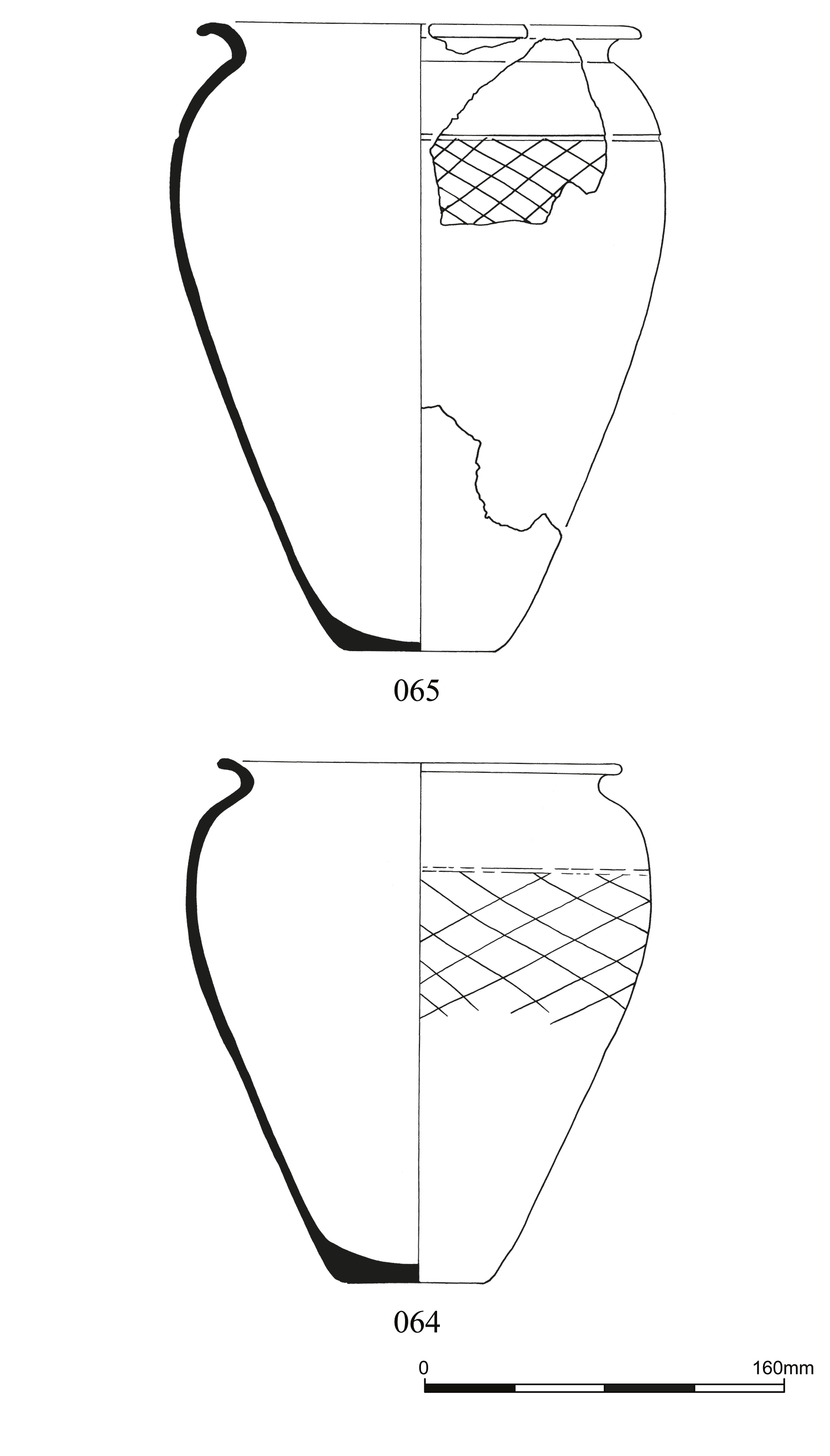
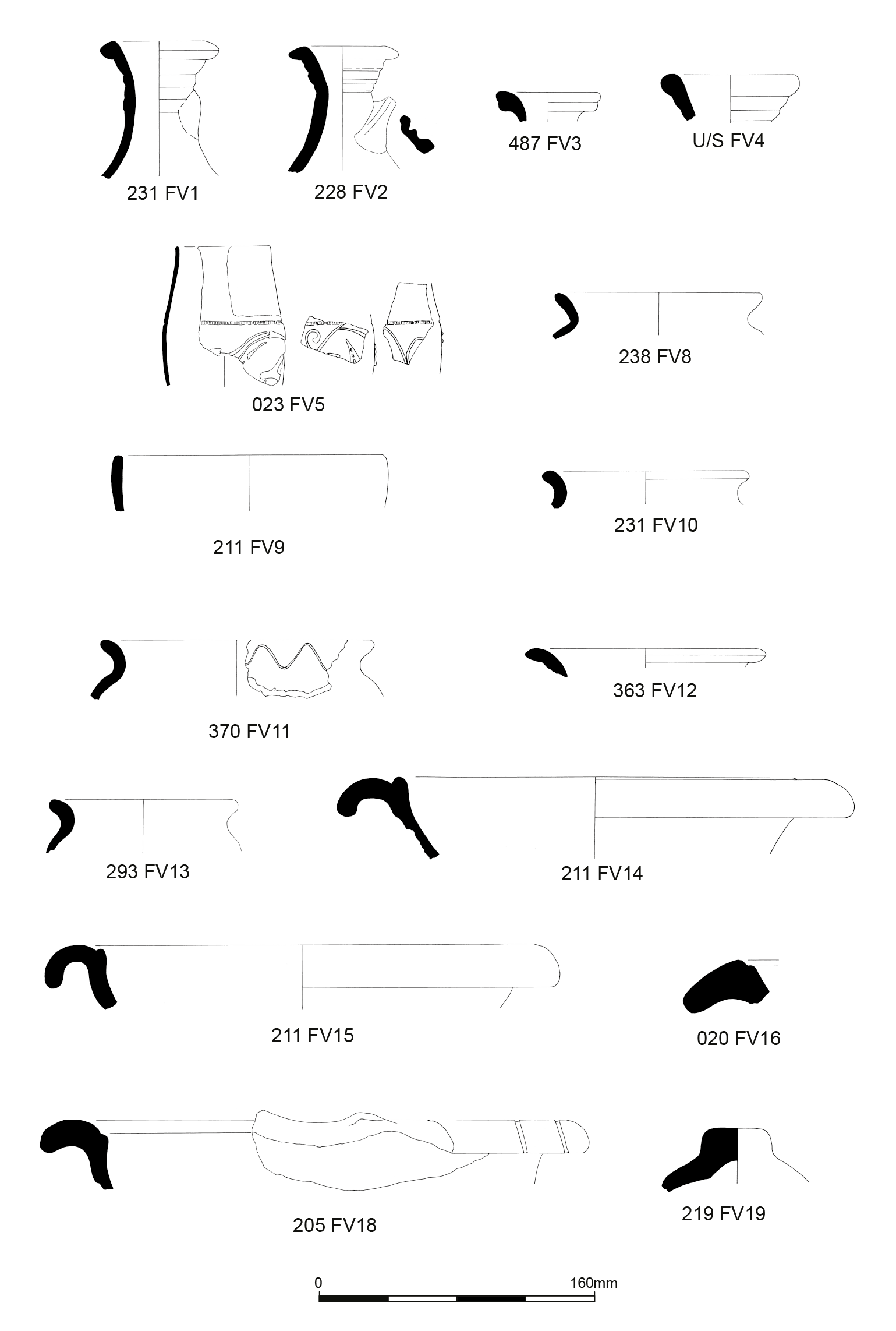
There were three near-intact vessels relating to the cremation cemetery: two black-burnished ware vessels from south-east Dorset (FV6 and FV7, 064/065), and a beaded rim, narrow-mouthed Rhenish beaker with barbotine decoration from Central Gaul (FV5 023) (Figure 19). The vessels are similar in date and type to those found at Beckford (Hogg 1949), Brougham (Evans 2004), and Birdoswald cemeteries (Evans forthcoming).
The two black-burnished ware jars were recovered from a single cremation. The larger vessel (065, FV7) contained the cremated remains of a mature adult female and was accompanied by a slightly smaller accessory vessel (064, FV6). Both vessels date to the second half of the 3rd century. The larger vessel looked like it had been burnt on one side, which would suggest it was near the funeral pyre when the individual was cremated. Similar observations were also noted during the Beckford excavations (Hogg 1949).
A second cremation (023) contained a beaded rim, narrow-mouthed Rhenish beaker with barbotine decoration in Gillam form 48 (FV5): the vessel contained the remains of an infant and dated to the second half of the 3rd century. The lower half of the vessel was not recovered, suggesting the vessel was placed rim down. In addition to the beaker, a single sherd of similar fabric type was found, but with a slightly darker fabric body and a slightly paler brown slip to FV5.
Other cremations were recorded but left in situ. The three vessels recovered all broadly date to the second half of the 3rd century.
The bulk of the pottery assemblage was recovered from the enclosure ditch and associated internal features. Table 2 presents the relative proportions of vessel forms by sherd count and estimated vessel equivalent. The assemblage was dominated by mortaria (30.49% EVEs), jars (26.87% EVEs), flagons (26.65% EVEs), bowls/dishes (6.39% EVEs), with cups, beakers and flasks forming 9.70% (by EVEs) of the assemblage.
The relatively high proportion of mortaria (30.49% by EVEs) is notable, as other sites in the area had much lower levels of these vessel forms. For example, the pottery recovered by the Maryport Roman Settlement project (Zant 2015, table 3) had mortaria forming 3.5% of the assemblage, from deposits of a similar date. The high proportion of jars and low proportion of samian ware, are typical of a 2nd-century rural site (Evans 2001), however the added dominance of mortaria and flagons, is more typical of an urban site and may suggest a continued presence or relationship with the military (Evans 2001).
At least three ring-neck flagons were recovered, two with evidence of handles (FVs 1 and 2) and one flask (FV 3). A further three possible flagon fragments were identified including a single strap handle, a complete base with foot-ring (similar in form to one recovered from Fisher Street, Carlisle, mentioned in Johnson et al. (2012, fig. 11 no. 1) and a neck fragment.
All of the flagons were in an oxidised fabric that were mostly of local origin or regional origin, which date to the late 1st to mid-2nd century by form. These dates coincide with the flagons produced at Fisher Street, Carlisle (Johnson et al. 2012), as well as a similar flagon (FV4) found at the Castle Street excavations (Taylor 1991, fig. 309 no. 50), that has a slightly earlier date of mid-late 1st century, with slight variations continuing to the mid-2nd century. As Croom (2008) states, the ring-neck flagon was a long-lasting form, being made from the pre-Flavian to the late Antonine period, which falls within the assemblage date range. There was also an introduction of locally produced flagons in Carlisle from the mid-1st century (Howard-Davies 2009, fig. 300 no. 12). These flagons would be comfortable in an early 2nd-century date.
A total of 16 sherds (620g) of amphora were recovered, forming 4.13% of the assemblage by sherd count (13.1% by weight). The majority (15 body sherds) were from Dressel 20 olive oil amphorae produced in Baetica, southern Spain. A single body sherd was from a vessel of North African origin, and may have been used to transport olive oil.
Soil conditions in the north-west of Britain are not conducive to the preservation of samian ware, rendering it soft and powdery with badly degraded surfaces. The material from this site is no exception. Thirty-five sherds were examined from a maximum of 31 vessels. With sherds so degraded, it was impossible to tell whether sherds from different contexts could have come from the same vessel.
Where Dragendorff forms (Dr.) could be determined they were as follows: Dr.37 (five sherds), Dr.27 (one sherd), Dr.33 (five sherds, two possibly from the same cup), Dr.18/31 or Dr.31 (three sherds), Dr.18/31R (one sherd), Dr.79R (one sherd), Dr. 45 (one sherd, joining), bowl (three sherds), and dish (one sherd, joining).
The assemblage was too small for statistics to be meaningful. There was one decorated sherd of Flavian date from South Gaul (no. 1 below) and three sherds from two East Gaulish vessels in the orange fabric typical of the Argonne, of late 2nd or possibly 3rd century date. The rest was Central Gaulish, spanning the 2nd century. Three sherds were from Les Martres-de Veyre, of Trajanic-Hadrianic date, the rest from Lezoux. Forms Dr.27 and Dr.18/31R are typical of the first half of the 2nd century, and Dr.79R and the mortarium form Dr.45 of the late 2nd century.
The proportion of sherds of the decorated form Dr.37 (25.7% of the total samian assemblage) seems unexpectedly high, particularly on a rural site, though the proximity of the fort may help to explain this. Unfortunately, only three sherds showed enough decoration for identification, and whether any came from the same bowl is impossible to tell (Figure 20).
There was one example of a repair: a circular rivet hole had been drilled in the form Dr.18/31R.
In the following text, figure types are taken from Oswald (1936-37), Central Gaulish motifs from Rogers (1974), and parallels from Stanfield and Simpson (1958). The potter numbers are those that appear in Hartley and Dickinson (2008-12).
1. Form Dr.37, South Gaulish. Badly abraded sherd from the upper zone of zonal decoration showing a long-stalked grass tuft with a vertical motif placed diagonally to each side. There would have been animal types to each side, though too little of the animal on the right-hand side survives for identification. Decoration of this general type was common at La Graufesenque in the Flavian period. An identical tuft with the same side motif occurs on bowls of form 29 by Vitalis ii (Knorr 1919, Taf. 83E). c. 70-100 CE (205).
2. Form 37, Central Gaulish, showing abraded decoration in the style of Igocatus of Les Martres-de-Veyre, with his characteristic wavy-line panel borders with dot-rosette junctions. Panels show the prisoner (O.1146), a festoon with beaded cup (Rogers U62) at each end over the vine scroll (Rogers M31), and a repeat of O.1146. A bowl from Chester (Stanfield and Simpson 1958, pl. 19, 237) shows the festoon with beaded cups. The motif inside the festoon is ill-defined, both here, on the Chester bowl and on one from Carlisle (Stanfield and Simpson 1958, pl. 18, 225). The ovolo, barely visible on the sherd, is likely to have been Rogers B29. c. 100-120 CE (Area N3 U/S).
3. Form 37, Central Gaulish. Badly degraded sherd showing panel containing the man (O.688) with a twist placed diagonally beneath. The type was used by Cinnamus ii and other potters of the Antonine period at Lezoux. A stamped bowl by Cinnamus shows it with a similar twist beneath. c. 140-180 CE (315, slot 25).
In addition to samian wares, 23 sherds (39.6g) of other fine table wares (Figure 21) were also recovered, forming 5.94% of the assemblage by sherd count, 0.84% by weight, and 9.51% by EVEs. Twenty sherds of a Central Gaulish, narrow-mouthed Rhenish beaker (Gillam Type 48) with floral barbotine decoration and black slip (FV5) were recovered from Grave 023, dating to the first half of the 3rd century. The beaker was used as a cremation urn and was found alongside a single sherd of a similar type of beaker but with a lighter slip and fabric. The remaining fine ware sherds comprised a single fragment of Lower Nene Valley Colour-coated ware dating from the mid-2nd to 4th century CE, and a heavily abraded sherd of Central Gaulish black slip ware. Both were found within the main enclosure ditch (Contexts 081 and 219).
A total of 271 sherds, weighing 2.292kg, of utilitarian coarse wares were recovered, forming by far the greatest component of the pottery assemblage at 70% by sherd count (48.41% by weight and 56.46% by EVEs). The coarse ware group includes: black-burnished wares, oxidised wares (including white wares), and reduced wares that may be produced locally, such as at Carlisle, as well as national products from the Cheshire plains/Severn Valley or north-west.
Black-burnished wares formed 44.96% of the overall assemblage by sherd count (30.81% by weight), and 11.01% by EVEs. The majority of these products came from the Dorset region. The forms present include jars/cooking pots and a dish.
Oxidised wares formed 19.9% by sherd count (14.74% by weight) and 37.53% by EVEs, with fabrics made locally, possibly at Fisher Street, Carlisle, and nationally traded wares possibly from the Cheshire Plains or Severn Valley. The oxidised vessels mostly consisted of flagons, mortaria, and lids.
Reduced (grey) wares and East Yorkshire Calcite-gritted ware (EYCT) formed 5.17% by sherd count (2.86% by weight) and 7.92% by EVEs. The forms present include a single jar produced in East Yorkshire and three greyware jars of unknown origin.
A total of 45 sherds, weighing 1385.3g formed 11.63% of the overall assemblage by count (29.26% weight, and 23.85% by EVEs). The majority of the mortaria were produced in wares predominantly from the Carlisle and wider area (MOX1, MOX3, MOX4, MOX6, MOX7, MOX9 and MOX10), most of which correspond to established fabric type series for the region (for example Hird 2010; Hartley 2012a; 2012b; Leary 2019). A single example (FV15, in fabric MOX6) was produced at the Fisher Street kilns (Johnson et al. 2012) in Hartley's Fabric 3 (2012b, 107) and is stamped by the potter Docilis. Also present were regionally produced 'Raetian' (Hartley 2012a, 107, Fabric 4, Raetian 1) mortaria with a brown slip (MOX1). Four mortaria base sherds, from at least two vessels were produced at military kilns at Holt, north Wales, during the late 1st and early 2nd century (MOX2 approximates to HOL OX, Tomber and Dore 1998, 207). There were mortaria sherds present produced in two fabrics (MOX5 and MOX8) of unknown source.
There were two mortaria with joining sherds across contexts: FV15 sherds from contexts 211 and 343, and FV19 sherds from contexts 205 and 224.
The supply of mortaria to the site was predominantly vessels produced in Carlisle and/or the north-west. The mortaria assemblage has a relatively narrow date range, with vessels produced broadly from the late 1st to 2nd century CE, but with a number of examples dating from c. 110/120 to 150/160 CE. The absence of Mancetter-Hartsill and Lower Nene Valle products, common from the second half of the 2nd century and later, contrasts with the assemblage from Oxford Archaeology North's excavations at the nearby fort vicus (Leary 2019, 87).
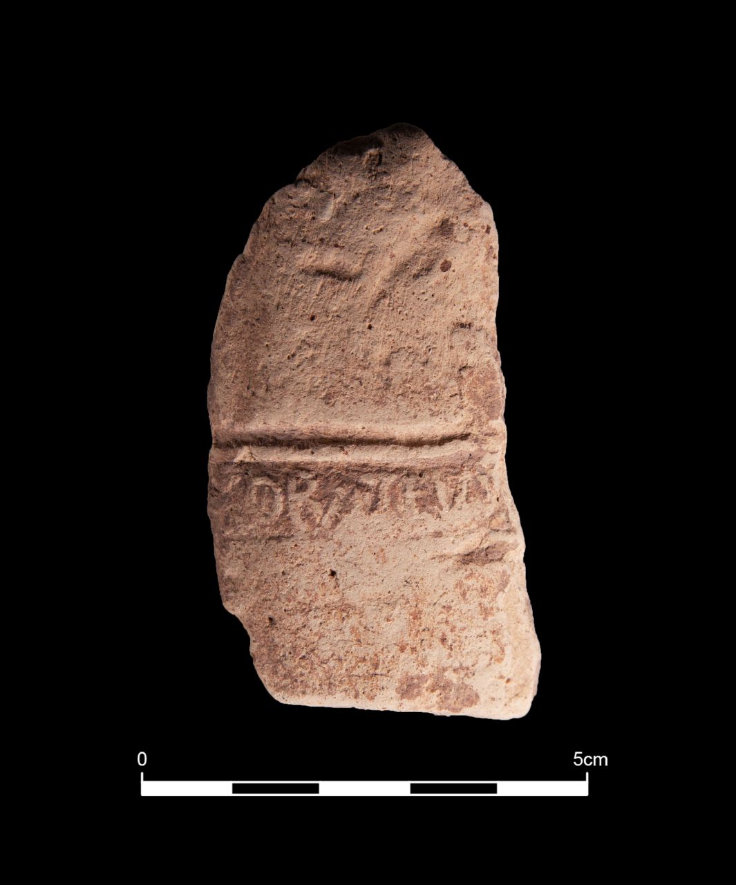
There were three joining sherds from context 205 (FV 18) with at least three, right-facing, stamps impressed close to each other across the flange; there would normally have been a similar arrangement on the left-facing side of the spout. The mortarium is notable in having a distal bead on the flange.
The sherds had an orange-brown fabric, which was powdery in texture. There was no indication of any surviving slip and the surface and stamps were pitted in places – all the result no doubt of depositional conditions. The fabric had frequent inclusions, minute to small in size. These included quartz, a red-brown material, and a less common black material. The trituration grit included widely dispersed, angular, medium-sized, milky quartz.
Although the stamps are badly damaged, it has been possible to identify them with virtual certainty as from a die now designated INC114 in the Mortarium Project. Other stamps believed to be from the same die are from Tarraby Lane in the Hadrianic Wall fort at Stanwix, 1km from the centre of Carlisle (Smith 1978, 46, no. 74 and fig. 20); one from St John's Church and one from the Northern Lanes (Hartley 2019, appendix 2, 375-6, no. 31); and one from Milecastle 50 on Hadrian's Wall (Simpson 1935).
The fabric, profile and distribution would best fit with production at Carlisle within the period 110-140 CE.
Two joining sherds from Context 211 were in a fairly fine-textured orange-brown fabric with traces of a matte red slip. The fairly frequent inclusions are minute to tiny and include mostly quartz, with few slightly larger quartz, black and red-brown. Very few trituration grits survive, but enough to show that they were fairly widely dispersed in the upper area and that they included quartz, red-brown and possibly quartz sandstone with rare black particles.
The stamp is too fragmentary to identify with complete certainty, but it is probably from one of the many dies of a potter known as Docilis 3 who operated out of numerous workshops in the north-east of England (Hartley and Webster 1973; Johnson et al. 2012). Their production overall covered a period from the late 1st century to perhaps the last quarter of the 2nd century, with the production of stamped mortaria ending c. 160/65 CE.
This Maryport mortarium can be attributed to Doc(e)ilis's Carlisle production in Fisher Street. The stamp could perhaps be from the same die as Johnson et al. (2012, fig. 10, no. 22) with part of the D, O and C. This mortarium is likely to be Hadrianic to early Antonine in date.
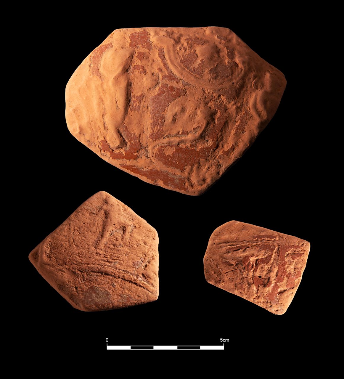
Three flange fragments and two body sherds were recovered from context 106 (FV17). None of the flange fragments were joining; and the two body sherds were joining. The inside surfaces were absent owing to depositional abrasion, and all are in powdery condition except for one of the flange fragments, which is vitrified. The sherds are in a cream fabric with frequent small to tiny transparent-brownish and white quartz inclusions, and rare red-brown and black inclusions. Only two red-brown sandstone trituration grits have survived the abrasion. The damaged stamp, reads ]IGOBATEVS in small letters, for Figobateus (Figure 22). It is not uncommon for this potter to impress the end of their name from the bead outward. The potter worked at the Hartshill kiln-site in Warwickshire (Tomber and Dore 1998, 189). Their mortaria are now known from Balmuildy and Croy Hill in Scotland (Hanson 2022, 125), and in England, from Cammeringham and Wildsworth, Lincolnshire (HER nos MLI52099, SLI3384); Chesters, Northumberland; Kettering, Northamptonshire; and Little Chester, Derbyshire (Hartley et al. 2022). Their presence at two sites on the Antonine Wall and the surviving spout of the Kettering mortarium indicate that the potter was at work within the period 140-165 CE (Hanson 2022, 125).
The assemblage is relatively small, making any statistical analysis limited and, with most of the pottery being found in the enclosure ditch, spatial distribution was not possible.
The majority of the jars were black-burnished wares produced in south-east Dorset (DOR BB1). In addition, locally or regionally sourced imitations of Gillam form 132 and 135 (FVs 12 and 13 respectively) were also present. Gillam form 135 (FV12) dates from the late 2nd to mid-3rd centuries while the Gillam 1976 form 3 (FV11) dates to the first half of the 2nd century. There were two other jars in a local reduced fabric as BBW imitations, which consisted of a slightly uneven everted rim cooking pot similar to Gillam form 132, but more akin to those at Fisher Street (Johnson et al. 2012 , fig. 13 no. 20/21). As they are imitations it is likely they date from the Hadrianic period or later (Johnson et al. 2012).
There was only a single confirmed lid, recognised by the circular-shaped handle and gradual flare; however, no rim survived. The lid was made from a local source and has a close parallel with one recorded from the Lanes (McCarthy 1990, fig. 32, no. 191) that dates from the second half of the 2nd to early 3rd century.
The table wares include bowls, dishes, cups and beakers produced in samian, other fine wares and coarse ware. The majority of the table wares were samian ware produced in Central Gaul with only a few from east and south Gaul. Most of the samian wares were bowls of form 37 and 18/31R produced in Central Gaul, along with form 33 and 27 cups. Two fragments of beakers produced in Central Gaul and the Nene Valley were recorded on a possible road surface.
The only coarse table ware was a single black-burnished ware dish (FV9, Gillam 1976 form 77) identified by its rim. It was a simple, straight-walled rolled rim with burnished body; the fabric was typical of south-east Dorset.
Leary (2019) and Evans (2001) state that high proportions of flagons, dishes/bowls and beakers, are all associated with serving food in the Roman manner and is a characteristic feature of Romanised settlements with close links to the military and trade routes. However, the lack of dishes/bowls and beakers in the assemblage from this site contradicts this statement, with the majority of the fine wares being samian and typically dating to the Hadrianic to Antonine periods, suggesting that the site had a big 'Roman' influence, especially with the development of the fort to the north-west.
The pottery from the enclosure suggests that it was in continual use perhaps from the late 1st century or early 2nd to the middle of the 3rd century, with intensive activity taking place at the site during the 2nd century. There were also three samian bowls dating to the Flavian period; even though one of the bowls was unstratified, there were few obviously residual sherds as the assemblage is in keeping with a continued use, broadly dating to the 2nd century. Other potentially earlier forms include mortaria (FVs 17 and 24, 17), with types produced from the late 1st and through the 2nd century.
While there are some late 1st to early 2nd century vessels present (e.g. some samian wares), the absence of other types common in this period, such as reeded rim bowls and rusticated ware jars, was notable (Leary 2019, 85).
In addition, the lack of common later Roman types, such as Crambeck, Nene Valley fine wares, Mancetter-Hartsill mortaria and developed flanged bowls (Leary 2019, 85), suggest a concentration of activity at the site within the enclosure (and pottery deposition) during the 2nd century. At the same time the fort and vicus were expanding with pottery deposition peaking in the later 2nd to mid-3rd century, with wide-mouthed jars from Mucking being recorded (Leary 2019, 85). Only a single East Yorkshire Calcite-gritted ware was recovered outside of the enclosure area in Trench 5, which would indicate later activity, similar to the cemetery but further to the east of the enclosure.
The expansion of the vicus around the fort of Maryport and the close proximity to Hadrian's wall would account for the military aspect of the assemblage: a higher proportion of Dorset black-burnished ware jars was apparent in Carlisle around Period 4B beginning 125 CE (Howard-Davies 2009) as provisions for the army increased.
The supply of ceramics evident here can be regarded as normal, as similar patterns are noted at the Maryport settlement, in that black-burnished wares provide the bulk of the cooking wares and samian the table wares (Leary 2019, 100). Other notable differences are the minimal number of greywares and the unusually high number of mortaria and flagons, which may suggest a specialist vocation: however, given the small size of the assemblage, lack of internal features and spatial distribution, the intended function of the enclosure is not possible to determine. As the site lies relatively close to the fort, there was evidence for the fort's influence, such as the low amount of table wares, suggesting the enclosure was on the periphery of the fort rather than a true rural settlement as it was also in close proximity to a cemetery, which wouldn't have been a normal occurrence. The high proportion of decorated samian would also suggest continued links with the vicus (Leary pers. comm.).
Eleven fragments (901g) of ceramic building material (CBM) were collected, all of Roman date. Four fragments were unstratified, three of which were from the evaluation. Two fragments (including one unstratified) were from the area of the cremation cemetery. Most of the remainder were from area N2, from the NE arm of the main Enclosure 200.
Three flanged tegulae were present, all with the remains of the flange. An unstratified fragment from the main enclosure ditch was 19mm thick and had a short square-section flange that was abraded and not measurable. Two further fragments from the fills of the main enclosure ditch included one fragment with a rectangular-section flange, 56mm high and 23mm wide, and a body 29mm thick, and another fragment with a rounded inner edge to the flange, which measured 45mm high and 35mm wide, and the body of the tile was 30mm thick.
All other fragments were of uncertain type, and all were abraded. Six fragments were measurable and varied from 18 to 30mm in thickness. This range is commonly found in flanged tegulae, as seen in the identified examples, although some of the thicker pieces could be fragments of wall or floor tiles.
The fabrics identified in this small group represent a continuum of the same clay type with only slightly differing sizes of sand grains and sparse other inclusions. The differences in the flanges of the three flanged tegulae recovered may indicate that although the tiles were made locally, they may have been made by different production sites or different tilers operating in the same workshop. The sizes present may indicate that all tile fragments were parts of flanged tegulae and this may suggest a roofed building close to the square enclosure, demolition of which resulted in deposition of some rubble within the backfill of the ditch.
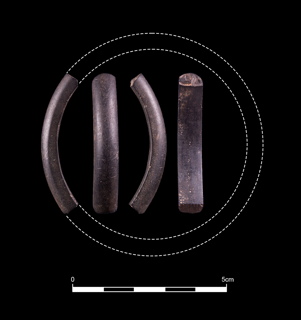
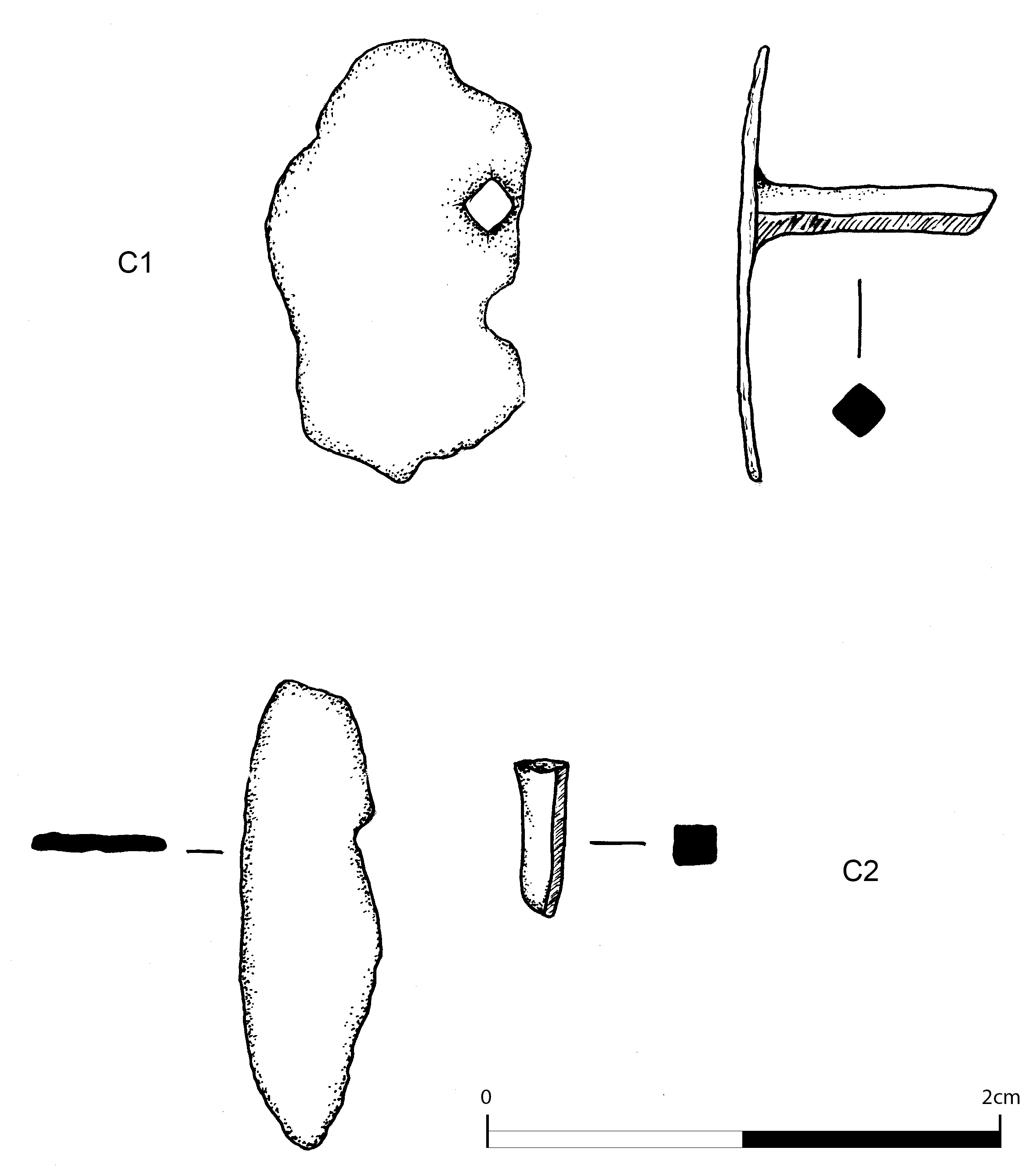
A single shale bangle fragment was recovered from the main Enclosure 200 to the north side of the south-eastern corner (Figure 23). It is a plain but very nicely made specimen, finished so well that no traces of manufacture survive, although the regularity suggests it was lathe-finished. Other finds from this ditch confirm a Roman-period date. While the main source of shale bangles in Roman Britain was Kimmeridge in Dorset (e.g. Calkin 1955), suitable shales are found elsewhere in Britain, especially in association with Coal Measures deposits, and cannot be characterised without destructive sampling (e.g. Allason-Jones and Jones 1994; 2001). Such finds are common from the northern frontier zone (e.g. Allason-Jones and Jones 1994; Wilmott 1997, 271-2).
Beautifully-made, rather fine D-sectioned bangle with slight facets on the faces rounding into the outer edge; inner near-flat. Finely polished to a medium lustre. There are thus no tool traces to assess technology, but its regularity suggests it was lathe-turned; slight irregularity in one area of the interior surface suggests hand-finishing of one spot. Signs of use-wear. Probably an oil shale given its dark grey colour, with hints of banding and lamination. Internal D 60-65mm (23% survives); L 44mm, W 5.5mm, H 7.8mm. Context 231, Area N2.
Two pieces of Roman glass were identified on site. One was found during the evaluation within cremation burial 064; it is a small shard of burnt glass and was probably blue in colour. Unfortunately, no other glass was found associated with the cremation and so further interpretation is difficult. Roman cremations found associated with or within glass vessels are relatively common (Cooke 1998, 14) and have been found locally, at Botchergate, Carlisle (Jones 2005). It is likely that this fragment was part of a vessel burnt during the cremation; the rest of the object either did not survive the burning or was not gathered up with the bone for deposition.
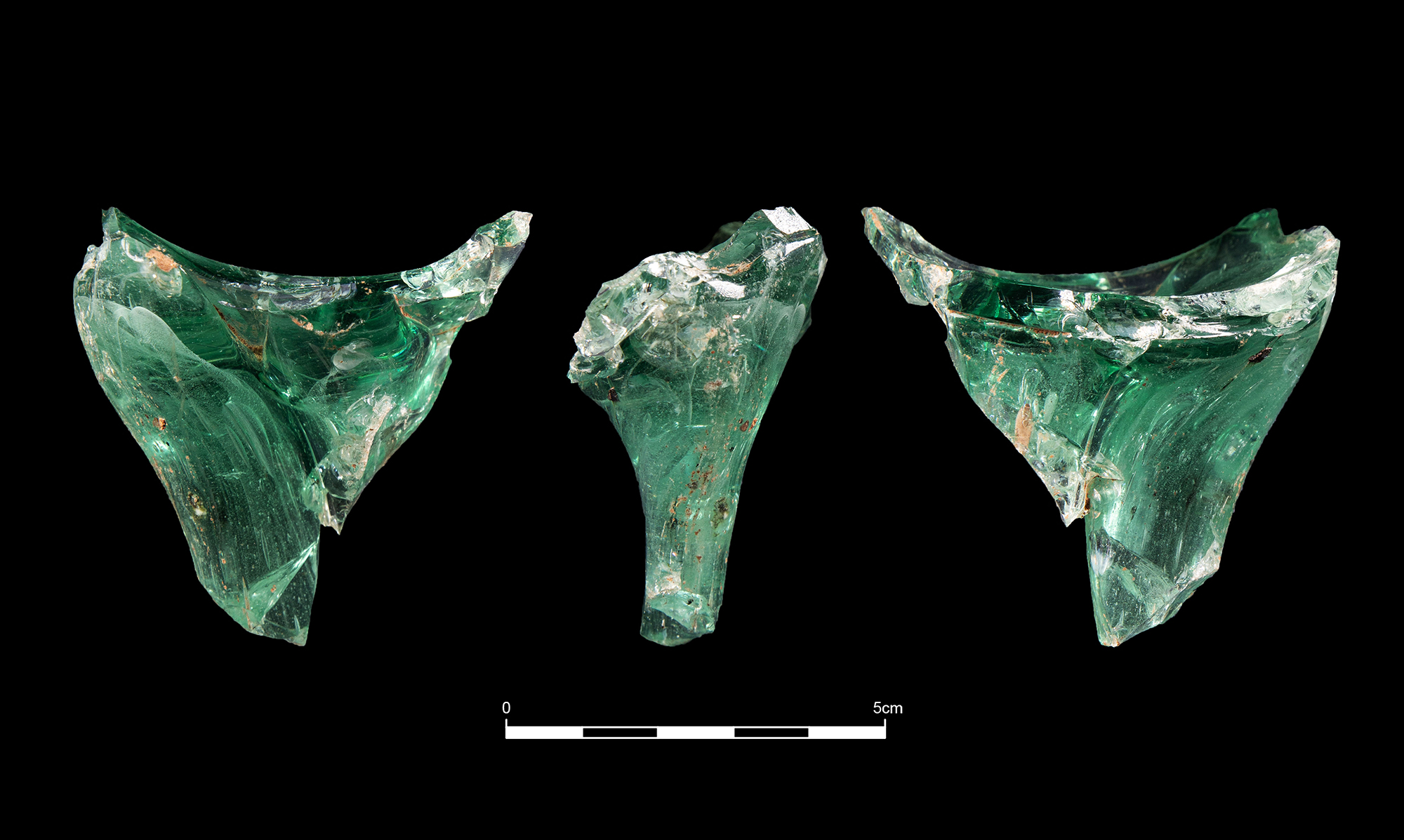
The second piece of Roman glass was found within the ditch of the main enclosure (200) during the excavation (context 336, Area N2). It is a fragment of body and a handle base in a pale blue-green glass (Figure 24). The ribbon handle would have had three ribs but one is missing, and contained frequent elongated bubbles and was pulled down to the concave surface of the vessel. The fragment of the body contained infrequent bubbles and is relatively thick, indicating that it is a probably part of a bottle. A similar example can be seen from the excavation at Elms Farm, Heybridge, Essex (Compton et al. 2015, no. 112).
A small assemblage of copper-alloy objects were recovered associated with cremation burial 064/065. This material is very fragmentary but includes three studs with sheet heads (Figure 25). Studs are mainly considered to be fittings and it is probable that these are all that survive from a larger burial good. This object could be a box or container destroyed either during the cremation or burial.
Several iron objects were also associated with cremation 064/065; these mainly consisted of a mix of nails and hobnails (Figure 26). Some of the iron had bone adhering to the surface; this was examined by Anderson (see below).
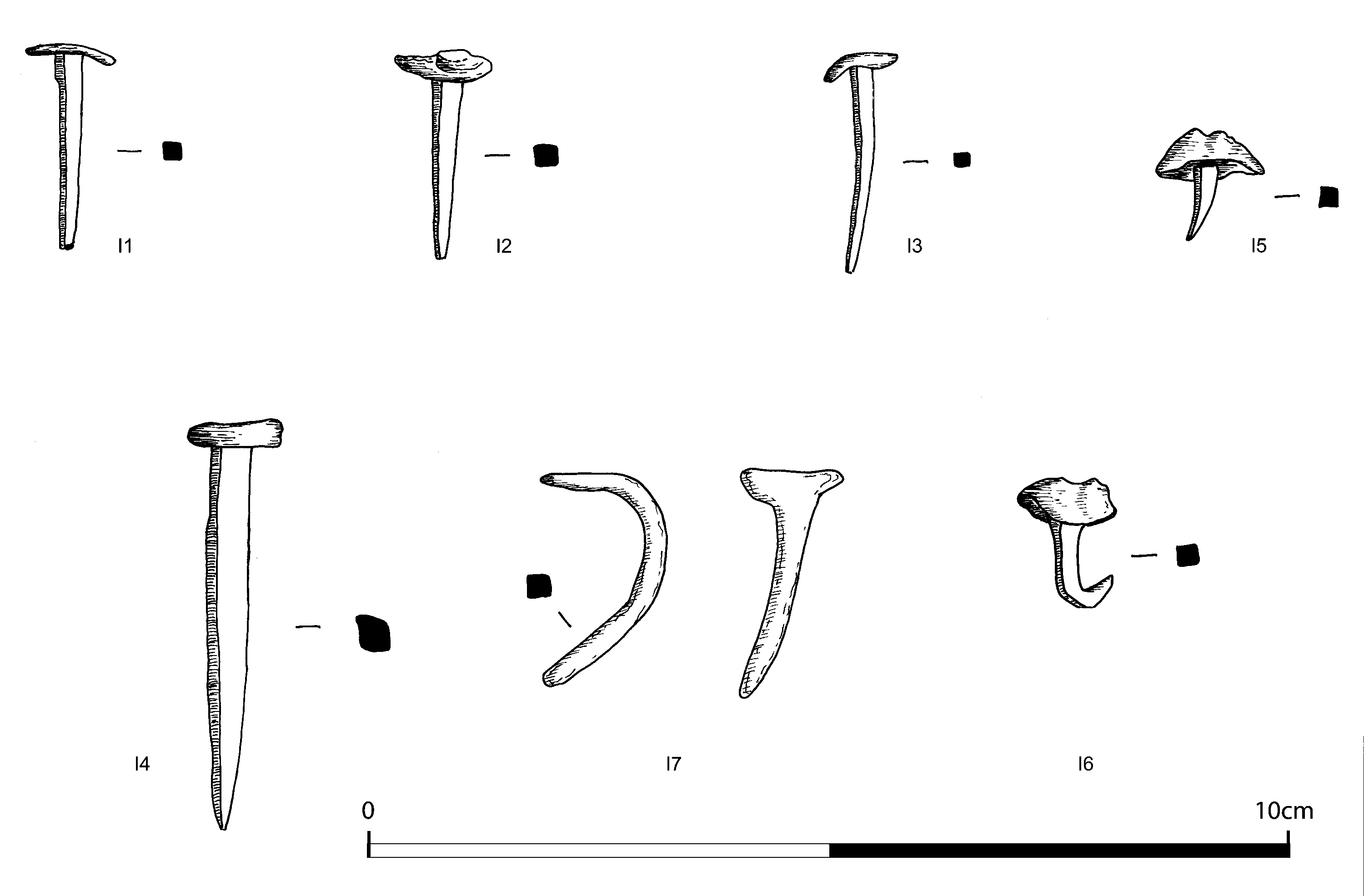
The presence of nails adds to the evidence from the copper-alloy studs that some sort of box or similar was included as part of the burial. Nails are common finds in Roman burials (both cremation and inhumation) and generally this seems to indicate that a coffin or other container was present (Dungworth 1998, 153).
The nails from the cremation can be divided into distinct groups based on their size and probable use. Thirteen nails are 22mm in length with flat, generally circular heads and the tapered shafts are square in section. These tend to be well preserved, but some are corroded and bent. Three longer nails were identified, up to 47mm long; two appear to be missing heads, but all have tapered square-section shafts. Three larger nails were identified in cremation 064, two were very corroded and not visible on X-ray but the third is 75mm in length with a broken head; the shaft tapers, is square in section and bent.
There are at least 19 hobnails in the assemblage from the cremation burials and they are all quite corroded and many are bent. The hobnails have a maximum length of 20mm and, where visible, rounded heads. It is probable that these were from shoes worn when their wearer was cremated.
In addition, an iron bow brooch was identified within cremation 064/065 (I7 in Figure 26). Only the upper bow of the brooch survived with no evidence of spring, hinge or pin remaining. The fragment of brooch was too small and corroded for detailed identification. Its fragmentary nature could be as a result of the cremation process, as seen in examples from cremations at Heybridge, Essex (Crummy 2015), with only the most substantial section of the brooch surviving the pyre.
A range of worked stone artefacts was found across the site (Table 3). The reworked rotary quern fragment is the most interesting (WS15) (Figure 27). It was originally made as an upper stone of a disc quern from a slab of medium-grained red sandstone and it would have had a radius of c. 240mm. After the quern stone had broken the segment was reused as some form of anvil. This secondary working has formed a shallow, pecked, circular hollow on the original flat upper face of the quern stone while a wide, shallow U-shaped channel has been pecked across the surface on the lower face. One end of the channel has been shaped to a curve and its opposite end appears to be truncated by breakage along one edge. There is an additional circular spread of pecking towards the perimeter on this lower face. The worked stone may then have been subject to heat damage as there is cracking and spalling across the piece. It was finally deposited in Enclosure 200.
| ID no. | Stone artefact type | Area | Context | Feature |
|---|---|---|---|---|
| WS12 | Plain hammerstone | N1 | 072 | Ditch 006 |
| WS1 | Whetstone | N1 | 088 | Ditch 006 |
| WS15 | Reworked rotary quern | N2 | 232 | Enclosure 200 |
| WS13 | Hammerstone | N2 | 232 | Enclosure 200 |
| WS5 | ?Sharpening stone | N2 | 323 | Enclosure 200 |
| Two slab fragments | N2 | 959 | Enclosure 200 Internal | |
| Four slab fragments | N2 | 963 | Enclosure 200 Internal |
A large hammerstone (WS13) was found with the reworked quern fragment (WS15) within Enclosure 200 close to the south-eastern corner. Made from a fine, elongated oval cobble of quartzitic sandstone, it bears traces of coarse pecking on either end and across much of the rounded surface. The anvil and the hammerstone may be evidence for a processing or manufacturing activity that occurred in the vicinity, the remains of which were subsequently dumped in the ditch. Perhaps the hammerstone was used with the anvil stone, either to shape the original hollow and channel, or else to process or crush a raw material using the anvil as a rest.
Another tool from the enclosure ditch is a possible sharpening stone (WS5). It is a pebble fragment on which the lower flattish face has a series of five small grooves, possibly made by a light blade or pin. These grooves are truncated by breakage.
There are six small fragments of red sandstone slabs, the largest of which has a straight worked edge and is 28mm thick. These may be fragments of the thin stone slabs originally used in walls. They all came from features inside the enclosure.
Three stone tools came from Ditch 006 (Area N1). The whetstone (WS1) is a fragment of a tabular, waterworn cobble of a distinctive grey quartzite. A high polish is present on one, slightly concave face, probably formed through sharpening a metal blade. The plain hammerstone (WS12) has a notch worked on one edge possibly to form a hand grip and then the curved broad end has been used as a hammer.
Cremated bone was recovered from two cremation burials found during the trial trenching. One of the cremation burials (064/065) comprised two Roman pottery vessels and bone was associated with both, but the material appears to represent a single burial and has been combined for the purposes of this study.
Bone was recovered in bulk samples and each of the cremation groups was sieved into four fractions (<2mm, >2mm, >5mm and >10mm), the largest three of which were sorted to remove stones etc. The weight of bone in the smallest fraction was estimated as a percentage of the weight of the whole retent. The bone was sorted into five categories: skull, axial, upper limb, lower limb, and unidentified. All fragment groups were weighed to the nearest tenth of a gram, and those in the first four categories were also counted to provide an average fragment weight. Measurements of maximum skull and long bone fragment sizes were also recorded. Observations were made, where possible, concerning bone colour, age, sex, dental remains and pathology. Identifiable fragments were noted. Methods used follow the Workshop of European Anthropologists (Ferembach et al. 1980) and McKinley (1994; 2004).
Table 4 shows the bone weights and percentages of identified bone from the two features containing cremated human remains, and the proportions of bone identified from the four areas of the skeleton (skull, axial, upper limb, lower limb). Expected proportions are provided in the first row.
| Context Total | wt(g) | % ident | % skull | % axial | % upper limb | % lower limb |
|---|---|---|---|---|---|---|
| Expected* | 18.2 | 20.6 | 23.1 | 38.1 | ||
| 023 | 18.9 | 28.0 | 92.5 | 7.5 | - | - |
| 064 & 065 | 616.2 | 52.6 | 14.2 | 19.3 | 19.8 | 56.0 |
Both burials produced relatively small quantities of bone. Mays (1998, table 11.2) notes that the combusted weight of an adult skeleton has a mean of around 1500g for females and 2300g for males. The largest quantity of bone in this assemblage came from 064/065, but is less than half of the average female weight.
Skull fragments are over-represented among the identifiable material in one of the burials, and lower limb fragments were over-represented in the other, with axial and upper limb fragments under-represented in both. In both burials, there were plenty of long bone fragments but most were too small to determine whether they belonged to upper or lower limbs. It has been suggested that 'it should be possible to recognise any bias in the collection of certain areas of the body after cremation' (McKinley 1994, 6). However, there is also some bias inherent in the identification of elements. McKinley notes the ease with which even tiny fragments of skull can be recognised, and conversely the difficulty of identifying long bone fragments. These figures can therefore provide only a rough guide to what was originally collected for burial. However, the unusually low proportion of cranial remains in burial 064/065 is worthy of note. It seems likely that they were removed through truncation, suggesting that they may have been placed in the upper part of the vessel.
Fragment sizes were generally medium to small in this group but rates of identification are comparable with other cremations from Roman sites. Urned cremations tend to contain less fragmented remains and rates of identification are generally above 60%. The small quantities of bone from context 064 were, on average, much smaller than those recovered from within vessel 065. The overall average weights of skull and axial fragments varied between <0.1–1.3g, while identified long bone fragments were on average 0.6–2.8g in weight. The largest skull fragment in the group was from 064/065 and measured 40mm across, and the largest long bone fragment, from the same burial, was 48mm long, but these two pieces were exceptional in this group, with most of the larger fragments measuring below 35mm in length.
Pit 022 was a shallow feature containing fragments of a 3rd-century pottery vessel. The pit contained fill 023, which was bulk-sampled for bone collection. The total quantity of bone recovered was only 18.9g.
The largest fragment sizes were 20mm from the skull and 28mm for a piece of long bone. The fragments had been fired to a relatively high temperature and were a uniform white colour.
This small assemblage comprised fragments of cranial vault including the central part of the frontal bone and part of the occipital, a petrous temporal, ribs, and pieces of shaft from unidentified long bones. The remains were those of an infant. The metopic suture at the centre of the frontal bone was fused, which generally occurs between 3–9 months of age. The size of this individual's long bones suggested that he/she was no more than 12 months of age at death.
This burial lay 5m to the north-west of 022 and contained 616.2g of bone, collected as bulk finds from contexts 064, 064/065 and 065 and in three samples from the same groups. The samples and bulk finds from each context group have been combined. The majority of bone came from 065 (494g). In addition, 15g of bone was identified as animal/bird, and it is possible that further fragments of animal bone could be included in the unidentified portion (total weight 292.1g). The bone was cream in colour and comprised a high proportion of small fragments, although the largest weight of bone was from the >10mm fraction. The largest fragment sizes were 40mm from the skull and 48mm for the identified long bones.
Identifiable fragments included cranial vault (including a large fragment of temporal, and part of the frontal bone), four tooth root fragments, a possible unerupted crown fragment, mandible with 4+ open tooth sockets, mandibular ramus, clavicle, scapula, vertebral facets and bodies including the fifth lumbar vertebral body, ribs, fragments of sacral ala, iliac crest, ischium, proximal and distal humerus, femoral condyle, finger phalanges, talus fragments, and shaft fragments of the major long bones.
The supra-orbital ridges appeared gracile, suggesting a female individual, and some of the bones, such as the near-complete lumbar vertebra and some finger phalanges, were small and also likely to be female. Cranial sutures were still open and this, together with the presence of a possible unerupted tooth, might suggest a young individual. However, there was evidence for degenerative joint disease on some of the vertebral fragments, suggesting that the individual was mature. Despite this, there was no evidence for duplication and the bones were probably from a single individual. There was no sign of pathology in the surviving dental remains. The individual was probably a mature adult female.
The fragments of animal bone included some bird long-bone shaft fragments, and pieces of pig and duck.
Only a small proportion of the Roman cremation cemetery was excavated during the evaluation, and the area was not investigated further during the excavation. The two burials that were recovered represent the incomplete remains of a young infant and a mature adult female. This limited evidence suggests a similar pattern to that seen at the broadly contemporary Roman cremation cemetery at Brougham, where individuals of all ages and both sexes were found to be buried, and adults were associated with pyre goods that included a range of animal remains (Cool 2004).
Only a small number of zooarchaeological remains were recovered on site, most of which derived from the cremation deposit in context 065. All bones were highly fragmented which, together with their burnt state, made identification to species difficult.
The bones from cremation 065 could represent pyre goods (Anderson, above) and could have derived from as few as two animals; a small pig (pelvis and tibia fragments) and a duck (tibio-tarsus fragment). Additional bird long bones were recorded that could not be identified to species. They could be part of the burial or may represent feasting associated with the funeral.
A cattle vertebra from Ditch 006 (Area N1) had been butchered finely, cut in two vertically, suggesting a more recent date, probably post-medieval.
Archaeobotanical evidence from the Romano-British period in Northern England has largely revealed a mixed cereal economy mainly reliant upon wheat types but also with barley present in some areas. Past research has demonstrated the importance of bread wheat as part of the diet of the Roman army, probably transported to northern Britain as part of the Roman military supply network (van der Veen 1988). Local agricultural production has also been shown to undergo changes to meet the needs of Roman settlement in the north with greater production of spelt wheat seen on some rural sites, highlighted particularly where developer-funded archaeological research has been carried out in parts of Yorkshire (Hall and Huntley 2007; Alldritt 2013). It has been suggested that up to fifty new plant foods were introduced to Britain during the Roman period, mostly types of fruits, herbs and vegetables, representing a major diversification in the British diet (van der Veen et al. 2008). In Cumbria excavation of the granary at Ambleside Roman fort produced evidence for bulk quantities of spelt wheat, with a small amount of emmer wheat, and rare barley, oat and rye grain, while there was no chaff present and very few weeds (Hall and Huntley 2007, 63).
Analysis of the archaeobotanical material from Maryport has enabled a rare opportunity to examine a rural Romano-British farming settlement in lowland Cumbria, which probably formed close social and economic connections to the nearby military establishment of Alavna. Samples produced substantial quantities of cereal grain, chaff and peaty fuel waste indicators as well as finds of weeds of cultivated ground and heathy turve indicators from the enclosure ditches and from some of the internal features, suggesting a rural Romano-British site involved in mixed arable production. The cremation deposits mainly produced charcoal fuel waste.
The bulk environmental samples were processed using a Siraf-style water flotation system (French 1971). The flots were dried before examination under a low-power binocular microscope, typically at ×10 magnification. All identified plant remains including charcoal were removed and bagged separately by type. Wood charcoal was examined using a high powered Vickers M10 metallurgical microscope at magnifications up to ×200. The reference photographs of Schweingruber (1990) were consulted for charcoal identification. Plant nomenclature utilised in the text follows Stace (1997) for all vascular plants apart from cereals, which follow Zohary and Hopf (2000).
The environmental samples overall produced quite low volumes of carbonised remains but discrete larger deposits of charcoal and cereal grain were occasionally recorded from some of the enclosure ditch and internal features (Tables 5-6).
Cremation pit 022 contained a quantity of Betula (birch) charcoal, probably fuel waste from cremation processes.
Three samples taken from the cremation vessel 064 contained charcoal fragments as well as small deposits of crushed hazel nutshell. The material included a single well-preserved grain of Hordeum vulgare var. vulgare (six row hulled barley) perhaps a ritual offering or trace remains of feasting activity associated with the cremation; a single fragment of poorly preserved charcoal that could not be identified; crushed and degraded hazel nutshell, possibly intrusive; and fragments of Alnus (alder) and Betula (birch), probably fuel remains from the cremation activity.
A small amount of cereal grain, charcoal and burnt peat fragments were recovered from these features (004, 006).
Trackway ditch (004) produced a scatter of degraded grain from various contexts, with much of this charred material probably trampled, windblown or otherwise mixed from nearby burning activity. One slot was likely to have been fairly close to a location of cereal drying or other source of burnt material as it produced a small deposit of nicely preserved spelt wheat and barley as well as some indeterminate cereal grain, and also contained fuel waste in the form of Quercus (oak) charcoal and burnt peat fragments. This could have been waste dumped from the nearby enclosure settlement. Another slot had a few traces of indeterminate cereal grain along with oak and hazel charcoal and a small amount of Prunoideae (cherries) type charcoal.
Ditch 006 had a few trace remains of cereal grain and charcoal but was mainly sterile. It contained a single oat grain in degraded condition, probably intrusive in the deposit, a few stray degraded barley grains, and a few traces of degraded hazel charcoal.
The samples were largely found to contain only trace remains apart from one slot from Enclosure 200, which produced a scatter of cereal grain together with a concentration of peaty fuel waste and was probably a discrete dump of waste material from cereal drying or cooking activity (Table 5).
| Context | 206 | 217 | 239 | 242 | 270 | 274 | 287 | 323 | 347 | 354 | 375 | |
| Cut | -204 | -215 | -237 | -240 | -267 | -271 | -284 | -314 | -346 | -348 | -369 | |
| Feature | Enclosure 200 sl5 | Enclosure 200 sl1 | Enclosure 200 sl9 | Enclosure 200 sl13 | Enclosure 200 sl17 | Enclosure 200 sl21 | Enclosure 200 sl22 | Enclosure 200 sl25 | Enclosure 200 sl28 | Enclosure 200 sl26 | Enclosure 200 sl34 | |
| Carbonised cereal grain and chaff | Common name | |||||||||||
| Avena sp. | oat | |||||||||||
| Triticum aestivum | bread wheat | |||||||||||
| Triticum spelta | spelt wheat | 1 | ||||||||||
| Hordeum vulgare var. vulgare | six row hulled barley | |||||||||||
| Hordeum vulgare sl. | barley | 5 | 2 | |||||||||
| Secale cereale | rye | |||||||||||
| Indeterminate cereal grain (+embryo) | 1 | 2 | 3 | 1 | ||||||||
| Triticum aestivum internodes | bread wheat chaff | |||||||||||
| Triticum spelta glume bases | spelt wheat chaff | 2 | ||||||||||
| Hordeum vulgare var. vulgare internodes | barley chaff | |||||||||||
| Cerealia stem fragments | cereal stem | 1 | ||||||||||
| Charcoal | ||||||||||||
| Quercus | oak | 1 (0.03g) | ||||||||||
| Corylus | hazel | |||||||||||
| Alnus | alder | |||||||||||
| Betula | birch | |||||||||||
| Prunoideae | cherries | |||||||||||
| Indeterminate | ||||||||||||
| Carbonised wild resources | ||||||||||||
| Burnt peat | 10 (0.79g) | |||||||||||
| Rhizomes | 2 (0.06g) | |||||||||||
| Calluna stems | heather | 4 (0.05g) | ||||||||||
| Corylus avellana nutshell | hazel nutshell | 1 (0.02g) | 2 (0.02g) | |||||||||
| Carbonised weeds | ||||||||||||
| Chenopodium album | fat hen | 1 | ||||||||||
| Persicaria lapathifolia | pale persicaria | |||||||||||
| Persicaria maculosa | redshank | |||||||||||
| Fallopia convolvulus | black bindweed | |||||||||||
| Rumex sp. | Docks | 2 | ||||||||||
| Plantago lanceolata | ribwort plantain | |||||||||||
| Galium aparine | cleavers | 1 | ||||||||||
| Scirpus (Isolepis) setaceus | bristle club rush | 1 | ||||||||||
| Carex sp. | Sedges | |||||||||||
| Bromus sp. | Bromes | |||||||||||
| Danthonia decumbens | heathgrass | |||||||||||
| Indeterminate weed |
Eleven samples were examined from cuts of Enclosure 200. Cut (284) was mainly found to contain fuel waste from burning peat for fuel, consisting of fragments of burnt peat together with rhizomes and heather stems. A few cereal grains were also present in (287) and consisted of spelt wheat and barley along with a few fragments of spelt wheat chaff. These remains probably came from cleaning out the burnt waste from a corn drier, with the material shovelled or swept into the nearest ditch. Similarly, cut (215) had a few degraded grains of barley while (271) and (346) contained poorly preserved and vesicular indeterminate grain. Barley grain radiocarbon dated from (217) returned a date of 50 BCE–55 CE (SUERC-88695). Cut (204) produced a single fragment of oak charcoal, probably a stray fragment of fuel waste from a nearby hearth.
Samples from (018) and (020) contained a substantial deposit of carbonised cereal grain and chaff together with some heather stems, suggesting peat or heathland was probably being cut for fuel. The cereal grain was a mixture of Triticum spelta (spelt wheat), Hordeum vulgare sl. (barley) and Avena sp. (oat), with a small amount of Secale cereale (rye) and a few traces of Triticum aestivum (bread wheat) also recovered. Large amounts of spelt wheat glume base fragments were found here also. This is probably a deposit of cereal-processing waste from numerous drying episodes swept out of a nearby hearth or corn-drying kiln and represents a significant find, indicating a mixed arable agricultural economy being practised at the site. Deposits (019) and (021) from Enclosure 200 contained no identifiable remains. The cereal-processing waste in (020) was possibly dumped in toward the end of the occupation of the enclosure.
Ten samples were examined from the internal features of the enclosure, producing general scatters of cereal grain and charcoal along with one very large discrete concentration of cereal-drying waste deposited in Ditch 957 (Table 6).
| Context | 901 | 904 | 911 | 913 | 915 | 935 / 936 | 938 | 948 | 959 | 963 | 706 | |
| Sample | 53 | 52 | 55 | 56 | 57 | 67 | 66 | 65 | 73 | 72 | 54 | |
| Cut | Pit 902 | Pit 910 | -934 | Feature 937 | -958 | -961 | -705 | |||||
| Feature | Linear 900 | Linear 900 | Linear 900 | Feature 912 | Feature 914 | Linear 930 sl2 | Ditch 930 | Pit 947 | Linear 957 sl1 | Linear 957 sl2 | Ditch 700 sl2 | |
| Carbonised cereal grain and chaff | Common name | |||||||||||
| Avena sp. | oat | 9 | ||||||||||
| Triticum aestivum | bread wheat | |||||||||||
| Triticum spelta | spelt wheat | 2 | 22 | |||||||||
| Hordeum vulgare var. vulgare | six row hulled barley | 10 | ||||||||||
| Hordeum vulgare sl. | barley | 11 | ||||||||||
| Secale cereale | rye | 1 | ||||||||||
| Indeterminate cereal grain (+embryo) | 1 | 2 | 1 | 73 | ||||||||
| Triticum aestivum internodes | bread wheat chaff | 2 | ||||||||||
| Triticum spelta glume bases | spelt wheat chaff | 65 | ||||||||||
| Hordeum vulgare var. vulgare internodes | barley chaff | 8 | ||||||||||
| Cerealia stem fragments | cereal stem | |||||||||||
| Charcoal | ||||||||||||
| Quercus | oak | 5 (0.12g) | 4 (0.72g) | |||||||||
| Corylus | hazel | 2 (0.41g) | 1 (0.11g) | 1 (0.15g) | 1 (0.03g) | 5 (5.13g) | 3 (0.59g) | |||||
| Alnus | alder | 1 (0.05g) | 2 (1.37g) | |||||||||
| Betula | birch | |||||||||||
| Prunoideae | cherries | |||||||||||
| Indeterminate | ||||||||||||
| Carbonised wild resources | ||||||||||||
| Burnt peat | 1 (0.17g) | |||||||||||
| Rhizomes | 1 (0.04g) | 2 (0.06g) | ||||||||||
| Calluna stems | heather | 15 (0.25g) | ||||||||||
| Corylus avellana nutshell | hazel nutshell | 2 (0.12g) | 1 (<0.01g) | 2 (0.03g) | 2 (0.01g) | |||||||
| Carbonised weeds | ||||||||||||
| Chenopodium album | fat hen | |||||||||||
| Persicaria lapathifolia | pale persicaria | 4 | ||||||||||
| Persicaria maculosa | redshank | 6 | ||||||||||
| Fallopia convolvulus | black bindweed | 1 | ||||||||||
| Rumex sp. | Docks | 3 | ||||||||||
| Plantago lanceolata | ribwort plantain | |||||||||||
| Galium aparine | cleavers | |||||||||||
| Scirpus (Isolepis) setaceus | bristle club rush | |||||||||||
| Carex sp. | Sedges | 1 | ||||||||||
| Bromus sp. | Bromes | 6 | ||||||||||
| Danthonia decumbens | heathgrass | 3 | ||||||||||
| Indeterminate weed | 12 |
Fill (961) of linear 957 contained a substantial deposit of carbonised cereal grain, cereal chaff and peaty fuel waste suggesting this was a waste deposit from a corn-drying kiln or hearth dumped into the feature. The cereal consisted of a mixture of spelt wheat and barley together with a few oat grains, and while the majority of chaff fragments were found to be from spelt wheat there was also barley chaff present in the deposit. Burnt peat fragments along with hazel charcoal showed the use of mixed fuel for cereal drying activity. Weeds of cultivated and disturbed ground such as Fallopia convolvulus (black bindweed), Persicaria lapathifolia (pale persicaria) and Persicaria maculosa (redshank) were conspicuous in the deposit and probably arrived accidentally with the cereal harvest. Interestingly, weeds of grassy places and heathland including Rumex sp. (docks), Bromus sp. (bromes), Danthonia decumbens (heathgrass) and Carex sp. (sedges) were also recorded and probably originated from cutting heathy turves and peatlands. While turve remains could indicate flooring, collapsed roofing and stabling material, in this case the association with cereal grain as well as finds of burnt peat, rhizomes and heather fragments suggested this was probably burnt as heathy turves or may have been part of the corn-drier structure. In contrast, fill (959) of cut 958 contained only crushed charred detritus and was otherwise sterile.
Ditch 900 contained a thin scattering of trace cereal grain together with some charcoal fragments. Fill (901) had a few degraded grains of spelt wheat and a mixture of oak and alder charcoal. Pit (902) in the base of (900) had a degraded indeterminate grain and fragments of hazel and alder. Cut (910) also produced hazel charcoal.
Pit (947) contained a large deposit of ashy fuel waste with hazel and willow charcoal present. This pit was found to be post-Roman, with the willow charcoal and a fruit stone (Prunus spinous) returning a date of 385-535 CE (SUERC-88698).
The environmental samples produced a number of discrete concentrations of carbonised cereal grain and chaff from the Romano-British enclosure features, in particular from Ditch 957. The cereal identification indicated a mixed arable agricultural economy being practised during the Romano-British settlement of the site, involving the production of spelt wheat and barley, but also with smaller amounts of bread wheat, oat and rye recorded. The presence of spelt and bread wheat in particular suggested crops probably being grown to meet Roman taste and demand, perhaps to supply the nearby Roman military fort. There was probably continuity from the Iron Age or earlier in the use of barley by the local population and this remained an important crop throughout the occupation of the settlement. Oat and rye may have been used as fodder crops for over-wintering horses and other animals, in addition to being used for human consumption.
Peat and heathland were being cut for fuel for processes such as cereal drying, cooking and other domestic purposes such as heating. The finds of burnt peat and peaty fuel indicators such as heather stems and rhizomes were found to align closely with the peaks in cereal recovery, in particular in Ditch 957 and also in part of Enclosure 200 (284) which contained a scatter of mixed cereal processing waste and fuel.
Charcoal including oak, hazel, alder and birch were found throughout the Romano-British features and suggested cutting of mixed deciduous open woodland for fuel and construction purposes. Results from the Roman cremation burials (pit 022 and vessel 064) indicated birch and alder were the main fuels being used on the funeral pyres.
The remains have significance in understanding Romano-British rural settlement in north-west England, in particular the intensification of agriculture to meet increased demand.
Three paired samples and one single sample were submitted for radiocarbon dating (Table 7). The earliest dates came from the lower fill of the main Enclosure 200, with charred barley (Hordeum sp.) grain producing a date of 50 BCE to 55 CE (SUERC-88695), while hazel (Corylus sp.) charcoal from the same context produced an even earlier date of 365 to 200 BCE (SUERC-88696) (both at 95% probability). Dates of 165 BCE to 20 CE and 100 BCE to 20 CE (95% probability: SUERC-88694, SUERC-88693) were obtained from paired samples of charred barley (Hordeum sp) from the lower fill of Ditch 006, while a single sample of burnt bone from the cremation cemetery produced a date of 90 to 245 CE at 95% probability (SUERC-88676).
The latest dates came from the interior of Enclosure 200, with willow (Salix) charcoal producing a date of 385 to 535 CE (SUERC-88698), while a charred blackthorn fruit stone (Prunus spinous) from the same context produced a date of 425 to 570 CE (SUERC-88697) (both at 95% probability).
The early dates obtained from material from the lower fill of the main enclosure ditch (200) indicate that the settlement had its origins in the pre-Roman Iron Age. This was also the case for Ditch 006, with the radiocarbon dates suggesting occupation during the period immediately preceding the Roman invasion. The dates for the cremation burial place it squarely within the Roman period, while the dates from the interior of the enclosure suggest that it remained in use as the Roman period in Britain was drawing to a close.
| Lab. no. | Context | Type | Date BP | 95% probability | δ13C |
|---|---|---|---|---|---|
| SUERC-88676 | Evaluation: Cremation 065 | Burnt human bone, lower limb | 1836±24 | 90–245 CE | -19.6‰ |
| SUERC-88693 | Area N1: Ditch 006, fill 072 | Cereal grain: barley | 2032±19 | 100 BCE–20 CE | -23.8‰ |
| SUERC-88694 | Area N1: Ditch 006, fill 072 | Cereal grain: barley | 2050±24 | 165 BCE–20 CE | -23.2‰ |
| SUERC-88695 | Area N2: Enclosure 200, fill 217 | Cereal grain: barley | 2001±24 | 50 BCE–55 CE | -23.3‰ |
| SUERC-88696 | Area N2: Enclosure 200, fill 217 | Roundwood charcoal: hazel | 2207±24 | 365–200 CE | -26.4‰ |
| SUERC-88697 | Area N2: Pit 947, fill 948 | Fruit stone: Prunus spinous (blackthorn) | 1548 ±24 | 425–570 CE | -27.1‰ |
| SUERC-88698 | Area N2: Pit 947, fill 948 | Roundwood charcoal: willow | 1620±24 | 385–535 CE | -25.3‰ |
Rectilinear enclosures, morphologically similar to that identified at Netherhall Road, are a relatively common but poorly understood feature within the archaeological record. Widely known from cropmarks on aerial photographs and as upstanding features consisting of a bank and ditch, but seldom excavated, these features have generally been assigned a Romano-British date based on the pottery recovered from the ditches of the few excavated examples. Many of the known examples are in upland areas where they have been spared the deep plough damage of modern agriculture and are now protected as scheduled monuments. Consequently, research has tended to concentrate on non-invasive methods such as spatial distribution and morphology, but the opportunity to gain a greater depth of understanding through excavation has only been available in very limited quantities.
Much of the research into the morphology of enclosures of this nature was carried out by Robert Howard Bewley from aerial photographic evidence, with them being divided into sub-groups based on their shape and enclosed surface area. With an enclosed area of 3250m² (57m by 57m internally), the Netherhall Road enclosure falls squarely within Bewley's Sub-Group 13 (2900–3400m², 3220m² average) of square and sub-square enclosures. Bewley (1994, 27) records five sites within Sub Group 13. Morphologically it bears the greatest similarity to Site 5531 (Bewley 1994, 42), which Bewley (1994, 33) suggests is morphologically similar to the smaller Romano-British sites in Sub-Groups 11 and 12 and may be part of a hierarchy of farm sites.
Although the morphology of the main enclosure is reminiscent of other enclosures within the north of England that have traditionally been assigned to the Romano-British period, radiocarbon dates suggest that the settlement at Netherhall Road may have had origins going back into the pre-Roman Iron Age. However, despite the earlier radiocarbon dates, the pottery recovered from the enclosure ditch was all Romano-British, ranging in date from the 1st to the 4th century CE. The majority of the pottery was recovered from the upper fills of the ditch with no clear stratigraphic relationship between the earlier and later pottery, suggesting that it was accumulating within the general area prior to ending up in the ditch after the enclosure fell out of use. Dates obtained from the interior of the enclosure suggest that it may have remained in use up until the mid-6th century CE, taking it beyond the end of the Roman period.
While there was a clear stratigraphic sequence between the earlier and later enclosures, the lack of any artefacts or material for radiocarbon dating within the former meant that the timescale between the two could not be determined. However, the unfinished nature of the earlier enclosure might suggest that the decision was taken during construction that it was not large enough to meet their needs and it was re-excavated as a larger enclosure. This is perhaps borne out by evidence from a number of the slots where the two ditches converged, suggesting that they were both open at the same time. The unfinished enclosure provides a possible insight into how these enclosures were constructed, with the laying out process consisting of excavating narrow slot trenches prior to excavating the ditch to its full width and depth.
The Netherhall Road enclosure is not the only Romano-British farm site within the vicinity of Maryport, with another one having been identified to the south of the town at Ewanrigg. Identified from aerial photographs, this site was first investigated through a limited programme of excavation during the late 1950s (Blake 1959), with a later programme of works taking place in 1986 and 1987 (Bewley et al. 1992). This site is double-ditched and falls into the category of sub-oval enclosures but, although morphologically different from Netherhall Road, a number of parallels can be drawn between the two sites. Both were surrounded by substantial ditches, with the recorded section at Ewanrigg measuring 4.3m wide by 1.6m deep, and an area of paving was identified within both enclosures. Although the majority of the pottery from Ewanrigg was dated to the 4th century CE a few of the sherds suggested earlier occupation dating to the 1st or 2nd centuries, indicating that it may have been occupied throughout the Roman period. Radiocarbon dates taken from a pit sealed beneath the paving provided a Bronze Age date, and, like the Iron Age dates obtained from Netherhall Road, may indicate a continuation of occupation from the prehistoric period.
Another native rural site within the Maryport area that may have been in use during the Romano British period was the small multivallate fort on Swarthy Hill. It was located in close proximity to Mile Fortlet 21 so presumably would also have had very close contacts with the Roman military. Further afield in Cumbria, enclosed Romano-British farm sites have been excavated at Oughterby (Bewley 1986), Silloth Farm (Higham and Jones 1983), Dobcross Hall (Higham 1981), Crosshill (Higham and Jones 1983), and Burgh Road, Carlisle (Kirby 2008).
Although the analysis of aerial photographs carried out by the likes of Bewley has identified numerous rural sites of potential Romano-British date, the wider interpretation and context of these rural farm sites and how they would have fitted in with the incoming Roman army is hard to analyse owing to the very limited number of examples that have been comprehensively excavated. Indeed, until very recently the lack of information relating to confirmed Cumbrian native rural sites from the later prehistoric period was considered so pronounced that in a 2007 paper Railton used the subheading 'The “missing” Iron Age' and cited an English Heritage document that described Cumbria as a 'black hole' in terms of Iron Age archaeology. This situation has not been helped by the fact that Roman-period research has largely concentrated on the military aspect of the Roman occupation and consequently the excavation of farm sites has tended to be rather limited. It is only in very recent years, thanks partly to the advent of developer-funded archaeology, that an improving picture is beginning to emerge. The compiling of information has been helped by projects such as The Roman Rural Settlement Project (Allen et al. 2018), which suggests that prior to 1950 there were only six confirmed Roman-period rural sites within a vast area of northern England extending from Merseyside and including Cumbria and Northumberland, a total that had risen to 174 by 2013. These included farms (117 sites), roadside settlements/vicus (29 sites), a village (1 site), ports (3 sites), villas (4 sites), and field systems (20 sites).
Despite the improving picture, the number of excavated sites is still somewhat limited with The Roman Rural Settlement Project recording 47 farm sites within the north-west of England. These consist of a concentration of sites around Merseyside, with a smattering of sites close to the coastal regions of Lancashire followed by a further concentration in Cumbria, most notably around Carlisle and along the Solway Firth close to the heavily militarised Roman frontier. These were subdivided into enclosed and unenclosed sites with a further subdivision between rectangular/square enclosures (17 sites) and circular/oval enclosures (9 sites). The distribution of square/rectangular confirmed Romano-British enclosures in north-west England, such as that at Netherhall Road, is even more marked, with a concentration of seven sites around Liverpool and a further seven in close proximity to Hadrian's Wall and down the Solway Coast.
This bias of excavated sites around Roman military installations has much to do with theories that revolved around native farmers being encouraged to settle within the vicinity of Roman forts and roads in order to supply the garrisons with food in exchange for Romano-British pottery. Indeed the small-scale excavations at Old Brampon, Jacob's Gill, Wolsty Hall, and the nearby site of Ewanrigg (previously known as Risehow) immediately to the south of Maryport (Blake 1959) were all excavated with this specific research agenda in mind. While it could be suggested that the excavation of the Netherhall Road enclosure has simply added to this bias, it is nonetheless of particular significance because it gave a rare opportunity to fully investigate a site of this nature.
The finds from the Netherhall Road enclosure would certainly indicate that there was a degree of contact and probably trade between the natives and the occupants of the nearby vicus. Some of the pottery suggests prestige items were being either traded or gifted, with amphorae that contained olive oil coming from southern Spain and North Africa, and samian and other fine wares being recovered. There was also a quantity of more utilitarian items, consisting largely of mortarium and other coarse wares that appear to have been largely locally produced. The majority of this pottery dated to the 2nd century CE, coinciding with the Hadrianic date of Maryport Roman Fort (constructed c. 122 CE), but a smaller quantity of late 1st-century CE pottery may provide some credence to the idea that an earlier fort relating to Agricola's campaign of 80 CE may have stood on the site of the Hadrianic fort. A possible spur from the putative Roman road leading to the enclosure suggests that the Romans may have been in regular contact with the native settlement.
Aside from the pottery, the other factor indicating Roman influence was the presence of ceramic building material (CBM). Anderson has suggested that the CBM possibly represents roofing or flooring tiles, suggesting the presence of a roofed building in close proximity to the enclosure. Although there was no evidence of this identified during the excavation, other excavated rural farm sites in Cumbria have indicated a move away from the vernacular circular architecture (roundhouses) during the 3rd and 4th centuries, with possible evidence of rectilinear buildings more in the Roman style being identified at sites such as Old Brampton, Wolsty Hall, Risehow (Ewanrigg), Penrith A-C, and Dobcross Hall (Higham and Jones 1983). While the interpretation of some of these rectilinear structures may still be open to discussion, the CBM found at Netherhall Road may indicate that the enclosure contained Roman-style buildings towards the end of its period of usage.
Much of the remaining evidence from the material recovered is indicative of a farm site with a mixed arable economy. Carbonised spelt wheat, barley, oats and small quantities of rye and bread wheat were all recovered from the interior of the enclosure. A fragment of rotary quern would suggest that the grain was being processed on site. There were also a few bones recovered suggesting that pigs and ducks may have been reared. It seems most likely that this agricultural produce was being traded for the Romanised goods found on the site, and as Alldritt has suggested, the spelt and bread wheat may have been grown to meet Roman taste and possibly to supply the Roman fort. It is also possible that rural sites close to Roman forts may have supplied recruits for the Roman army, but as Breeze (2018) has pointed out, this does not appear to have left any kind of evidence in the archaeological record.
Beyond the main enclosure, the trackway and parallel ditch indicate a well-trodden route leading from the foot of the Ellen Valley onto the higher ground to the south-west of the enclosure. Its purpose and whether or not it relates directly to the enclosure are unknown, but the radiocarbon dates are broadly contemporary, falling between the earliest ones for the enclosure and the dates indicated from the Romano-British pottery. These dates would suggest that it was constructed in the pre-Roman Iron Age although as with any ditch feature the dated material may be residual and have entered at a later date. With no obvious source of fresh water in close proximity to the enclosure, it is thought that it is most likely to have been obtained from the River Ellen and the comparatively gentle gradient of this track would have provided a much easier route back up the hill when laden down with water than the direct route straight up the embankment. This track may also have served other settlements in the surrounding area, within locations that were either not investigated or where the evidence no longer survives.
Although in close proximity to the enclosure, the cremation cemetery almost certainly relates to the fort and vicus rather than to the native settlement. Roman cemeteries are frequently situated adjacent to roads, giving some credence to the putative Roman road depicted on early Ordnance Survey map editions and represented on the ground by a slight hollow-way. The two excavated burials from this cemetery consisted of an infant and a mature adult female, both contained within ceramic vessels dating to the second half of the 3rd century. These individuals were clearly civilians, demonstrating that this cemetery served the wider community rather than just the fort. The presence of civilians was also noted at the nearby Beckfoot Roman cemetery (Howard-Davis et al. 2017), which is thought to have served the fort in its early years but was used by the wider population by at least the 3rd century. Similar vessels and grave goods were also identified at Beckfoot. Further south there was a gradual change from cremation to inhumation from the late 2nd century onwards (Cool 2011), but further north cremation appears to have remained in use until at least the 4th century CE. The Netherhall Road Roman cemetery was considered to be of national importance and no further work was undertaken beyond the excavation of the features disturbed during the evaluation. It is now a scheduled monument (Entry List No. 1406685).
The excavations undertaken at Netherhall Road were of particular significance because they offered a rare opportunity to investigate a native Roman-period rural farm site. Sites like this offer an insight into how the native population would have interacted with the incoming Romans but have been largely neglected in favour of military sites and consequently this subject is poorly understood. It is probably fair to conjecture that the degree of contact would have varied considerably from place to place, and it would require the excavation of sites with a greater spatial distance from the heavily Romanised areas to see if any patterns could be determined. With the Cumbria HER recording close to 900 enclosures of unknown period, many of which are likely to have been in use during the Romano-British period, the potential for the future study of this subject is substantial.
This work was funded by Story Homes Ltd. The authors would like to thank Cumbria County Council Historic Environment Service for advice throughout.
The site was excavated by CFA Archaeology Ltd under the supervision of Magnus Kirby. Many thanks to the archaeological team who worked on the excavation -Gary Savory, Hana Kdolska, Leigh Garst, Ewan MacNeilage, Tomasz Jenorowski, Cara Pearce, Marc Sidebottom, Georgia Andreou, Fraser McFarlane, Suzanne McGalliard, Aris Palyvos, David Swan, Jack Portwood, Stuart Mitchell and Andrew Brown.
The authors are grateful for the specialist artefact analysis provided by Felicity Wild, David Griffiths, Kay Hartley, Sue Anderson, Fraser Hunter, Christina Hills, Ann Clarke, Jennifer Thoms, and Diane Alldritt. Illustrations were created by Sam Griffith, Sarah Bailie, Shelly Werner and Graeme Carruthers. Finds photography was undertaken by Woody Musgrove. The text was commented on by Melanie Johnson and Katy O’Donnell.
Internet Archaeology is an open access journal based in the Department of Archaeology, University of York. Except where otherwise noted, content from this work may be used under the terms of the Creative Commons Attribution 3.0 (CC BY) Unported licence, which permits unrestricted use, distribution, and reproduction in any medium, provided that attribution to the author(s), the title of the work, the Internet Archaeology journal and the relevant URL/DOI are given.
Terms and Conditions | Legal Statements | Privacy Policy | Cookies Policy | Citing Internet Archaeology
Internet Archaeology content is preserved for the long term with the Archaeology Data Service. Help sustain and support open access publication by donating to our Open Access Archaeology Fund.
 Home
Home