Cite this as: Aryankhesal, F.F. 2024 The role of BIM and GIS in HS2 historic environment data management, an overview of HS2 Phase One, UK, Internet Archaeology 65. https://doi.org/10.11141/ia.65.5
High Speed Two (HS2) railway as the backbone of Britain's transport network, is more than a railway project. Beside building bridges, tunnels, tracks, and stations, the HS2 project includes the largest single archaeology programme ever undertaken in the UK. This programme is revealing more than 10,000 years of British history, from prehistoric times through to World War Two buildings.
A key aspect of archaeology is its association with location. Archaeology is one of the interdisciplinary fields like construction and economy in which 'place' matters. Without location, any archaeological data is lacking identity. Therefore, it is obvious that spatial data analysis is an integral part of the manipulation and management of archaeological data.
This article explains the role of GIS and BIM in manipulating historic environment spatial data in different lifecycles of this project.
The land required for construction of Phase One of HS2 from London Euston to Birmingham in the West Midlands (HS2 2017a), includes approximately 406 km2 (40600 Hectares) of land, which is over 230 km (140 miles) long. The land required to be constructed in Phase One of HS2 along the route from London Euston to Birmingham and the West Midlands, includes approximately 406 km2 (40600 Hectares) of land, which is over 230 km (140 miles) long. The route was divided into three areas for the enabling works – north, central, and south. Most of the archaeological works were undertaken by the Enabling Works Contractors (EWCs) and their specialist supply chain, and some archaeological works have been carried out by the Main Works Contractors (MWCs) and their specialist sub-contractors.
The remarkable aspect of this programme is the fact that historic environment considerations have been fully integrated with the overall HS2 construction programme, as an evolution of existing and recent approaches to the design and delivery of historic environment works associated with major infrastructure projects. To put this approach into practice, the Generic Written Scheme of Investigation: Historic Environment Research and Delivery Strategy (GWSI: HERDS) was developed (HS2 2017b). The HERDS is the lead document for all historic environment works, and delivers the commitments set out in the Heritage Memorandum (HS2 2017c), one of the Environmental Minimum Requirements (EMRs) for the HS2 project (HS2 2017d). The HERDS outlines the detailed implementation plan for the preservation and protection of the cultural and historic heritage of the areas affected by the project. The HERDS includes the strategies for research, assessment, and delivery of mitigation including measures aimed at minimizing the impact of the HS2 project on the historic environment. It requires the project to have regard for National Planning Policy Framework (NPPF) (Ministry of Housing, Communities and Local Government 2021), archaeology and built heritage standards, national guidelines and codes of practice appropriate to the project.
A series of technical standards support the HERDS and set out the more detailed guidance for technical methodologies and procedures. The specification for Historic Environment Investigations (HS2 2019a) defines the principal investigation techniques; all these different historic environment activities are captured within the GIS data.
The specification for historic environment investigation (HS2 2019a) under the HS2 GWSI: HERDS outlines the procedures, methods, and guidelines to be followed during the investigation process. It provides a common framework for the assessment and management of the historic environment, ensuring that all investigations are conducted in a consistent and effective manner. According to that technical standard, 30 different intrusive and non-intrusive investigation activity types have been determined to carry out Phase 1 historic environment evaluation and mitigation works.
Data management and recording is one the significant aspects of specifications for historic environment investigation. The guiding principle of HS2 historic environment data management are the use of a BIM strategy combined with GIS, and an asset information management system (AIMS) to set out requirements for the collection, management, and preservation of data and information generated during the project lifecycle, including design, construction, and operational stages
A key aspect of any historic environment data is its association with location. Archaeology is among the fields in which Place matters. Without location, any archaeological data are devoid of identity. Geographical location is an integral part of archaeological surveys. Like any spatial data such as census data and land use data, archaeological data is captured across geographic space, and is joined with geometrical shapes, such as historic buildings, test pits, trial trenches, and intervention areas in a specific location with a certain geographical coordinate system. Geographic Information Systems (GIS) is used to understand and analyse complex relationships and patterns in historic environment spatial data. GIS is a combination of software and hardware pieces, such as sensors, cameras, drones, scanners, monitors, software packages, printers, servers, video projectors, that systematically work together. GIS provides experts with powerful tools for capturing, gathering, storing, cleaning, analysing, visualising, mapping, and delivery of historic environment spatial data in different stages of evaluation, mitigation, and post-excavation archaeological works (Greene and Moore 2010).
Building Information Modelling (BIM) is a digital tool that allows architects, engineers, and construction professionals to work together to create an accurate, up-to-date model of buildings or structures by defining the assets of the construction This model can be used to visualise the design, simulate construction processes, and manage data effectively during the buildings' lifecycle. Additionally, BIM allows project stakeholders to make informed decisions based on real-time data and simulations, reducing the potential for changes and rework later in the project (Department for Business, Innovation and Skills 2012).
The integration of GIS into the BIM model provides a more accurate and comprehensive representation of the project and its surroundings, including the location and context of the assets. This information can be used to improve visualization and enhance asset management.
On the HS2 historic environment programme, a combination of BIM and GIS being used to enhance collaboration and coordination between design and construction teams, improve construction efficiency, and reduce the risk of errors and delays. To fulfil these important demands the BIM approach and GIS have been deployed in HERDS (HS2 2017b), which enable:
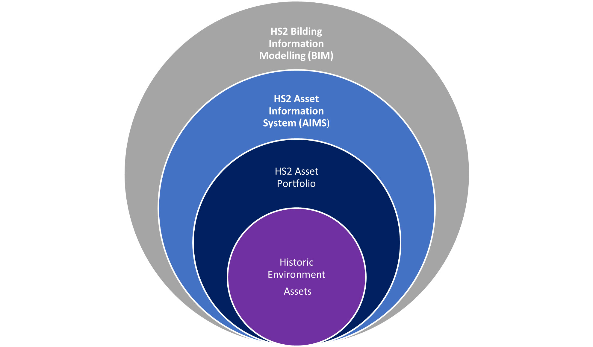
Assets are the core components of BIM models and are represented in the model as objects with properties and attributes. These objects can include walls, floors, windows, doors, mechanical equipment, electrical systems, and other elements of the asset. An asset portfolio refers to the collection of physical assets registered and managed by an organization's BIM model, such as buildings, roads, bridges, and other infrastructure. The term “asset information” is a generic term covering a range of information and data types which may sit within the asset portfolio (HS2 2015). These include, but are not limited to:
Asset Information Management (AIM) is the process of managing information about an organization's assets portfolio. The purpose of AIM is to ensure that the right information is available to the right people at the right time, to support decision-making related to asset management (Figure 2).
The HS2 Asset Information Management System (AIMS) is a software system that is used to manage asset information, and includes a database that stores information about assets, as well as tools for data analysis and reporting. An AIMS is designed to provide a central repository for information about each asset in the asset portfolio and BIM model, including data on asset performance, maintenance history, and other important information.
Also, it is integrated with other HS2 software systems, such as BIM, GIS, and Electronic Document Management System (EDMS) to provide a more comprehensive view of asset information. AIMS enables storage and access of the followings (HS2 2015):
The Data Structure Table (DST) is a critical component of the HS2 asset management system (AIMS), providing a consistent approach to recording assets information. The DST outlines the information required by HS2 assets, and the format in which this information should be stored (HS2 2021a).
The DST includes the following elements:
The DST is system agnostic, meaning it is not tied to a specific software or technology, but rather provides the detail necessary to create consistent, system-specific data standards and schemas. The HS2 historic environment DST has been developed in accordance with the HS2 Historic Environment technical standards and procedures, and HS2 Building Information Management (BIM) documents, ensuring consistency with the overall approach to historic environment investigation and management outlined in these documents. By providing a consistent approach to recording historic environment assets information, the DST helps ensure that all relevant information is captured, stored, and managed accurately and effectively, providing a comprehensive view of the historic environment assets within the HS2 project area.
The HS2 Asset Information Management System (AIMS), Asset Data Dictionary Documents (known as AD4s) serves as a printable digital template form allocated for each asset, in which the information related to an asset is registered and stored on AIMS. The attributes which are required to be filled in through investigations for identifying an asset, have been set out in AD4s according to their respective asset class DST. The use of the AD4 standardises the information about each asset, allowing for effective and efficient management and decision-making for the protection and preservation of the historic environment assets.
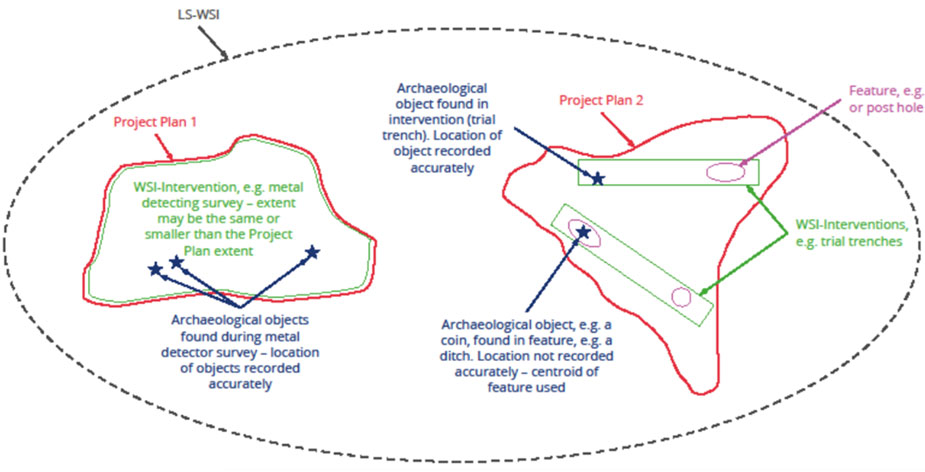
Historic environment assets refer to physical remains and cultural heritage sites that have historical, cultural, and/or architectural significance. These assets can include buildings, structures, landscapes, objects, and archaeological sites that have value and importance for their heritage, cultural, historical, or aesthetic significance. HS2 Historic environment assets based on their significance and function are divided into three categories, namely core assets, primary assets, and other assets.
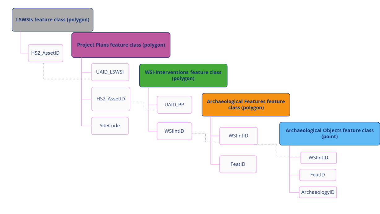
The top levels of Historic environment assets are core assets. These assets play a vital role in archaeological investigations. The geometry and location of core assets is decisive. Historic environment core assets are defined to record the location and extent of HS2 archaeological investigations. The information of core assets is recorded both in HS2 GIS systems and AIMS system. Also, the GIS and non-GIS information of other historic environment elements and assets is linked to these core assets through a Unique Asset ID (UAID), which is allocated for each core asset.
The HS2 historic environment core assets are (Figure 3 and Figure 4):
Under the core assets, the HS2 historic environment assets hierarchy comprises three primary classes of assets, which spatially situate within the core assets, and are related to them by Unique Asset IDs UAIDs (Figure 4). The information of primary assets only is recorded on the HS2 GIS system, however the core assets relating to them (LSWSIs and Project Plans) can be tracked on AIMS, as well.
These primary assets are:
There are other historic environment assets that their geometry and location is not as significant as core asset and primary assets, and that is why they are not recorded as GIS data. The information about these assets is collected according to their own special AD4, and the data is registered in HS2 Asset Information Management System (AIMS) only (HS2 2021b).
These assets are classified in seven types, as follows:
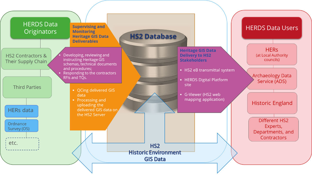
An efficient process for managing historic environment data within the HS2 project has been created. The process involves collaboration between the HS2 supply chain, third-party data providers, the HS2 Historic Environment team, and HS2 stakeholders, such as Archaeology Data Service (ADS) and Historic Environment Records (HERs) at local authorities, who use the data. The workflow covers all stages of data management, from data capture to delivery, and includes tasks such as cleaning, analysis, and visualization. The goal of the integrated workflow is to improve efficiency and provide benefits to all parties involved in the use and management of the historic environment data. For example, all the HS2 historic environment fieldworks GIS data, undertaken by HS2 contractors and supply chain, is assured, and processed according to HS2 historic environment standards and specifications, and deposited with HERs. This HS2 historic environment information can be used against the planning-related queries, development-control works and land management within the respective local authorities.
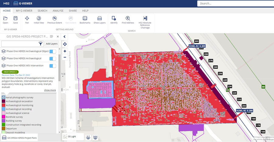
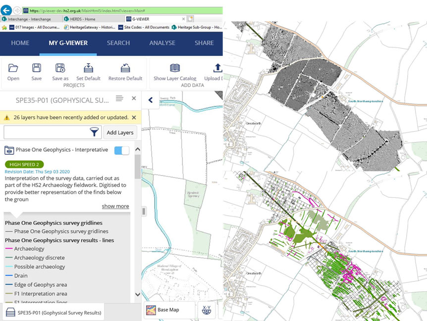
GIS data submitted is assured and processed by a dedicated HS2 Historic Environment Data Manager, who has the responsibilities of overseeing and monitoring the delivery of historic environment GIS data within the HS2 project. This includes tasks such as developing and assuring technical documents, responding to contractors' requests for information and clarifications, quality controlling the delivered GIS data, and processing and uploading the data onto the HS2 server. The goal is to ensure the delivery of high-quality GIS data for the HS2 project. On the other hand, another responsibility of the HS2 Historic Environment Data Manager is to deliver historic environment GIS data to HS2 stakeholders. This includes using tools such as the HS2 Electronic Document Management System (EDMS), and enterprise Bridge (eB) transmittal system, the internal HERDS Digital Platform site, and the G-Viewer, an internal web mapping application, to provide access to the data. The aim is to make the GIS data accessible and usable to all HS2 stakeholders.
According to the nature of Historic Environment surveys and activities data collection, there are five different GIS Schemas (HS2, 2019b), which each of them has its own datasets as follows:
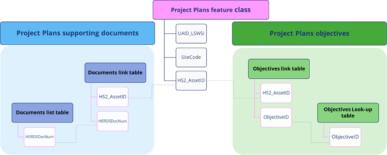
In accordance with HERDS strategy, GIS schemas were used to create a system, which connects historic environment assets spatial data to their respective non-GIS supporting documents (HS2 2019b). The goal is to make the management and analysis of archaeological data more efficient and organized. To build this relationship, the core assets UAID play the key role (Figure 8).
Historic Environment evaluation and mitigation works GIS data packages are submitted by the contractors, and then quality controlled, and assured by the Historic Environment Data Manager. The data is then processed and prepared to be uploaded on HS2 server and visualised and published on HS2 G-Viewer. For implementing this GIS data processing, a variety of GIS software and hardware pieces are utilised. The main GIS tools established on HS2 GIS systems are based on Esri ArcGIS products, Safe Software FME, and Python scripts.
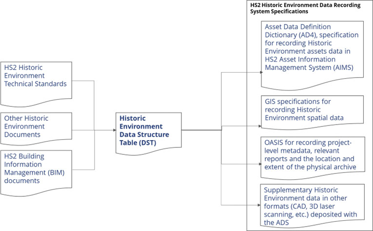
As mentioned in the previous paragraphs, the HS2 Phase One contractors were required to submit all the digital data generated during the implementation of the historic environment programme in different reports and data formats. According to HS2 GWSI: HERDS (HS2 2017b, HS2 2019a) and historic environment DST (HS2 2021a), this digital information is stored and archived is four different data recording systems, as follows (Figure 9):
As HS2's vision for the historic environment programme is to provide access to the artefacts and information in a variety of interesting ways that will enable people to learn about the story of a nation. The creation of HS2's historic environment physical and digital archive is an integral part of the lasting legacy of the programme to fulfil the above vision.
The interrelationship and hierarchy between HS2's historic environment assets, which have been recorded through their UAIDs in HS2 GIS systems and AIMS, are the glue for connecting the HS2 digital archive and physical archive.
I would like to express my appreciation to the HS2 Historic Environment Team. Their collective contributions have played a crucial role in the success of this paper. The expertise and insightful feedback from Helen Wass, along with Dr. John Halsted's wealth of experience, significantly shaped the trajectory of, and greatly improved, this paper. Gratitude is also extended to Michael Court, HS2 Historic Environment Lead, for his priceless encouragement.
Internet Archaeology is an open access journal based in the Department of Archaeology, University of York. Except where otherwise noted, content from this work may be used under the terms of the Creative Commons Attribution 3.0 (CC BY) Unported licence, which permits unrestricted use, distribution, and reproduction in any medium, provided that attribution to the author(s), the title of the work, the Internet Archaeology journal and the relevant URL/DOI are given.
Terms and Conditions | Legal Statements | Privacy Policy | Cookies Policy | Citing Internet Archaeology
Internet Archaeology content is preserved for the long term with the Archaeology Data Service. Help sustain and support open access publication by donating to our Open Access Archaeology Fund.
 Home
Home