Cite this as: Sparrow, T., Bain, K., Kimber, M. and Wilson, A.S. 2024 Visualising Heritage: using 3D immersive technologies to innovate, document and communicate rich narratives for HS2, Internet Archaeology 65. https://doi.org/10.11141/ia.65.7
This paper showcases the impact of using digital documentation and visualisation for strategically important heritage assets uncovered as part of the enabling works for HS2 Phase One at Birmingham Curzon Street, the site of the first intercity terminus station to be built in Britain since the 19th Century. This is demonstrated both through the role of digital documentation as a defined component of the excavation archive, but more importantly how the resultant digital content has been developed as an integral component of narrative story-telling both for multiple partners involved in the delivery phase of HS2 Phase One and with key stakeholder groups in mind from the point of capture. Collectively this rich heritage resource was used to demonstrably address strategic 'Knowledge Creation (KC)' and 'Community Engagement (CE)' objectives, identified within the Historic Environment Research and Delivery Strategy for HS2 (Halsted 2021). Notably this was realised through creation of rich 3D content for use in webinars, virtual tours, immersive narratives and with future educational resources, and the potential for interactive exhibition content part of our key strategic goal.
Our remit was to contribute lasting legacy through place-based research using digital documentation of the archaeological and heritage assets of former railway infrastructure, including elements of the booking office for the Grand Junction Railway (GJR)which opened to passengers in 1833; Stephenson's Roundhouse (the world's first Railway Roundhouse), operational 12th November 1837; and the iconic Curzon (Principal) Building, which opened in 1838 as the original terminus for the 180km long London-Birmingham Railway (Warwickshire Railways, 2023). Each was placed within the context of the wider historic environment of Digbeth and adjacent areas of Birmingham, inclusive of the social fabric connecting people, community and place as represented by the Eagle and Tun public house and its connection with community-scale endeavours recognising Birmingham's Music Heritage (Table 1). In terms of knowledge creation, our goal was to underpin understanding of the development of the railways and broader changes in the historic landscape (KC43); and to demonstrate how key changes in the technology of railway infrastructure would ultimately influence the distribution of goods and movement of people (KC54).
Digital documentation on-site during archaeological works at Curzon Street and the exhumation of human skeletal remains from Park Street Cemetery enabled capture of unique imagery to show how archaeologists affect the record themselves in terms of their methods of investigation, their response to the material and the decision-making process (KC46).
| Date | Description | Context |
|---|---|---|
| 1799 | Digbeth Branch Canal completed* | Part of the Birmingham Canal Navigations |
| 1807 | Land purchased by Church of St Martin to establish Park Street Cemetery# | Overflow cemetery for St Martin-in-the-Bullring |
| 1813 | Birmingham Gun Barrel Proof House** | Established by Act of Parliament |
| 1825 | Birmingham Medical School# | Established by William Sands Cox |
| 1833 | Grand Junction Railway | Opens to passengers |
| 1836 | Birmingham General Cemetery, Key Hill opens in the Jewellery Quarter# | Non-conformist cemetery established out of town |
| 1837 | Stephenson's Railway Roundhouse (Locomotive Engine House) completed | Architectural drawings (CZNST/54 - dated 23 Mar 1837; CZNST/53 - signed Grissell and Peto) inform development of Locomotive Engine House, first operational 12 Nov 1837 |
| 1838 | Birmingham station (Principal Building) and London and Birmingham Railway completed | Birmingham Station designed by Philip Hardwick (National Heritage List: 1343086; drawings CZNST/2, CZNST/7, CZNST/10, CNZST/26) opens 24 Jun 1838 as Birmingham's first terminus at Curzon Street for the London and Birmingham Railway which opens 17 Sep 1838 |
| 1838 | Railway Bridge spans the Digbeth Branch Canal* | 1838 section of railway bridge into Curzon Street spans Digbeth Branch Canal (National Heritage List: 1075609) |
| 1841 | Principal Building extended to the North | Additional hotel wing (Queen's Hotel) designed and added by Robert Benson Dockray (drawing CZNST/90 dated 21 Jul 1841) |
| 1842 | Roundhouse roof alterations | Design drawings dated 22 Aug 1842 (CZNST/61) are signed by Joseph George Branson, Edwin Gwythen and Robert B. Dockray. The form of the roof had changed from an open-air ring to a domed structure by 1843 |
| 1846 | London and North-Western Railway (LNWR) established | Merger of London and Birmingham and Grand Junction Railways |
| 1848 | Brookfields Cemetery, Warstone Lane opens in the Jewellery Quarter# | Church of England cemetery established out of town |
| 1851 | Birmingham New Street Station | Passenger services transfer to Birmingham New Street |
| 1852 | Birmingham Curzon Street Station established | Station name changed from Birmingham Station and with the exception of special excursions becomes a goods-only station |
| 1854 | Birmingham New Street Station | Official opening 1 Jun 1854 |
| 1860 | Roundhouse demolished | Demolition helped to accommodate increased goods traffic into Birmingham Curzon Street Station |
| 1863 | Birmingham City Cemetery opens at Witton# | Burials dwindle at Park Street Cemetery |
| 1899 | Eagle and Tun public house** | Permission granted September 1899 to construct the Eagle and Tun on the site of an earlier public house of the same name. |
'Visualising Heritage' is a research centre within the School of Archaeological and Forensic Sciences at the University of Bradford. Established with HEIF funding from Research England in 2013 to carry forward the legacy of landmark projects, initially as 'Bradford Visualisation', the team have been responsible for the development of wide-ranging capabilities that concentrate on the use of digital documentation for heritage assets (Gaffney et al. 2016a, 2016b). This encompasses scalar approaches to terrestrial and airborne capture, from the object scale to landscapes, including complex cityscapes. These capabilities have expanded recently with support from the Arts and Humanities Research Council for 'Capability for Human Bioarchaeology and Digital Collections' (AH/V01255X/1).
At Curzon Street we combined long-range terrestrial laser scans obtained using a FARO X330 laser scanner, with mobile mapping using a GeoSLAM Zeb Horizon device that has proven to be a fundamental tool for rapid digital documentation of industrial heritage and townscape heritage (Moore 2022). Scan data was also used to scale structure-from-motion (SFM) photogrammetry data captured using a Nikon D750 camera, and from extant imagery from other sources. Terrestrial laser scans were undertaken of the GJR Booking office (x3) and Robert Stephenson's Roundhouse (x36). These were combined with structure-from-motion (SFM) photogrammetry that was undertaken using a combination of pole-mounted and hand-held photographic records. A total of 667 images in RAW format were captured for the Grand Junction Railway Booking office, with a further 7,565 images captured for the Roundhouse. Collectively this image data alone represented 192 GB. Visualisations were modelled in Blender to compare archaeological evidence of the Roundhouse as-built, with the original architectural drawings (Science Museum Group 2023). Further reconstructions in Blender focused on presenting two different forms of the roundhouse roof construction, based upon Stephenson's original plans and contemporary engravings and architectural plans which showed that the roof form was changed early in its use to provide additional shelter for work on locomotives.
Terrestrial scan data and structure-from-motion photogrammetry were also used during the excavation of the former Park Street Cemetery to document brick-lined vaults and exemplars of earthen graves. Scan data was processed initially in FARO Scene, then combined with photogrammetry data using Reality Capture (EPIC Games).
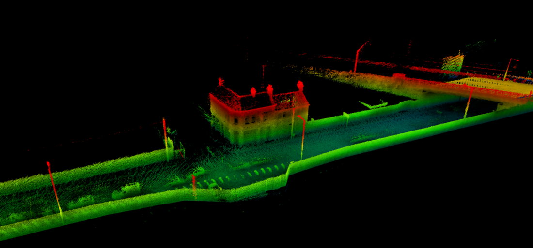
Mobile mapping data included GeoSLAM Zeb Horizon scans of the Grand Junction Railway booking office, Robert Stephenson's Roundhouse and the interior/ exterior of the Principal Building which were processed initially in GeoSLAM Hub/Draw and reprocessed recently with GeoSLAM Connect. Further scans sought to link the Railway Roundhouse and Grand Junction Railway with surrounding infrastructure, including the streetscape westwards from Curzon Street to Fazeley Street, showing the Eagle and Tun public house prior to demolition; and separately the immediate proximity of the Digbeth Branch Canal. These were augmented by aerial imagery provided by McAuliffes with ground controls, that was reprocessed and presented using Zoomify to show the full extent of the Grand Junction Railway assets in high resolution, prior to groundworks.
Opportunities for immersive capture through filming using Insta360 and GoPro cameras positioned relative to machinery meant that it was possible to combine both 'establishing' and 'point-of-view' shots to help to both contextualise and document the process of machining and archaeological groundworks as the Roundhouse was exposed. These working shots offer unique insight into the role of archaeology in documenting railway infrastructure of international importance.
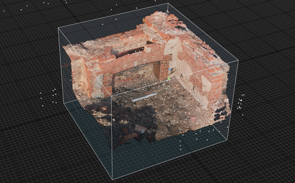
Architectural features were recorded from the earliest phase of railway infrastructure at Curzon Street representing part of the original Grand Junction Railway. This ensured that a record of elements of the booking office (including the fireplace) which were documented from laser scan data and SFM photogrammetry were captured and scaled (Figure 1).
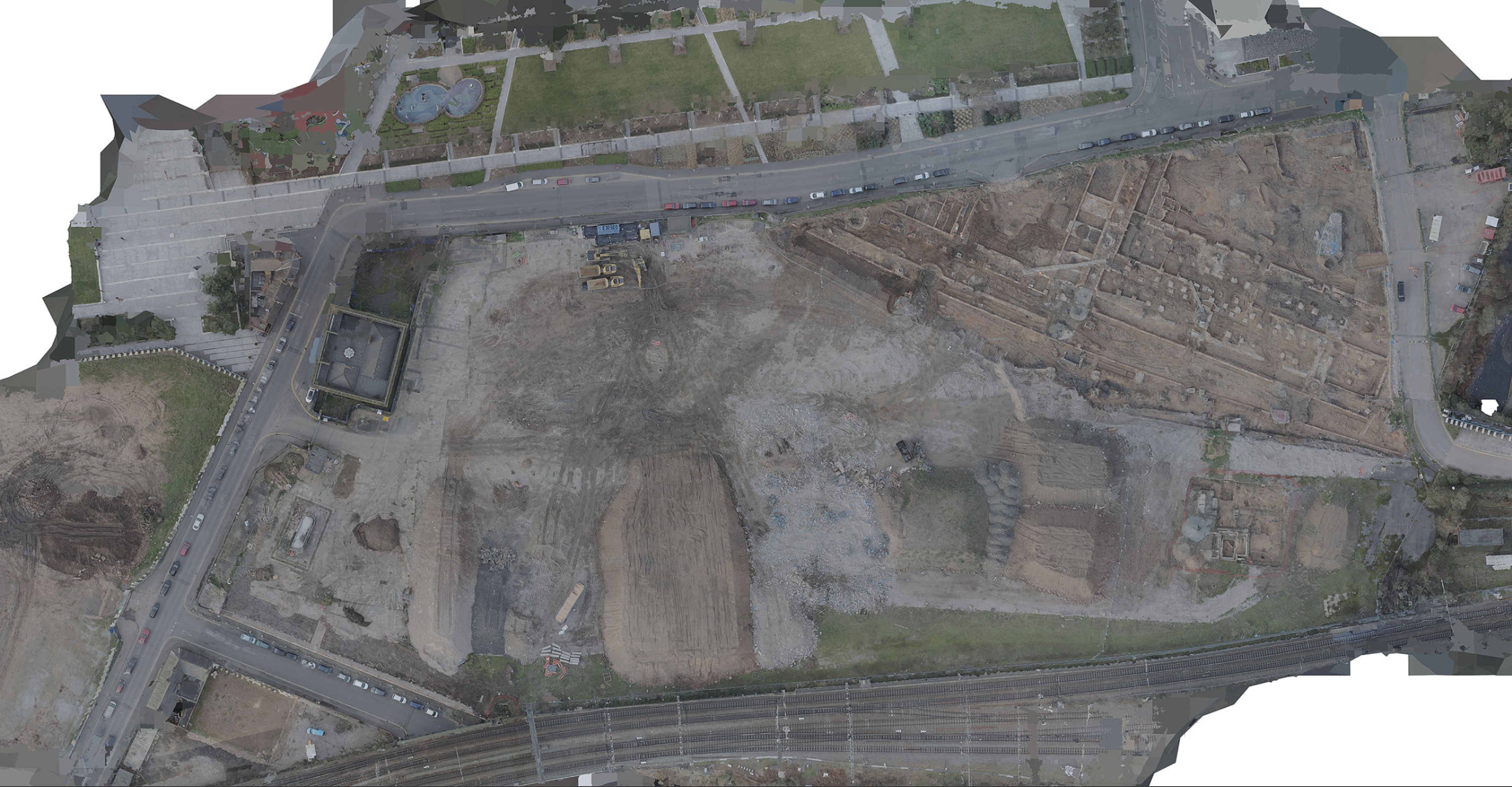
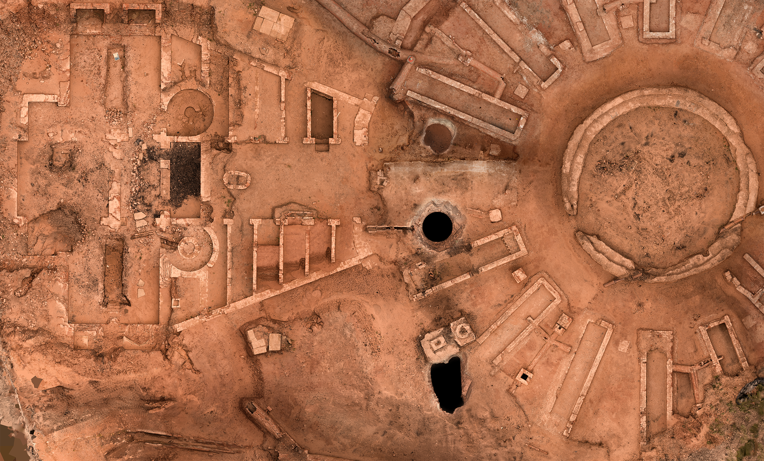
These elements of the original GJR infrastructure are shown in context using imagery from drone capture (Figure 2), relative to elements of the surrounding streetscape, adjacent Digbeth Branch Canal and alignment of infrastructure for the later Curzon Street terminus for the London and Birmingham Railway. Extant drone footage captured as part of the Phase 1 Enabling Works by McAuliffes, was processed using Reality Capture and tiled using Zoomify in order to contextualise the historic railway infrastructure of the Grand Junction Railway, showing the booking office and platform as well as the location of brick-lined drainage and foundations for wagon turntables.
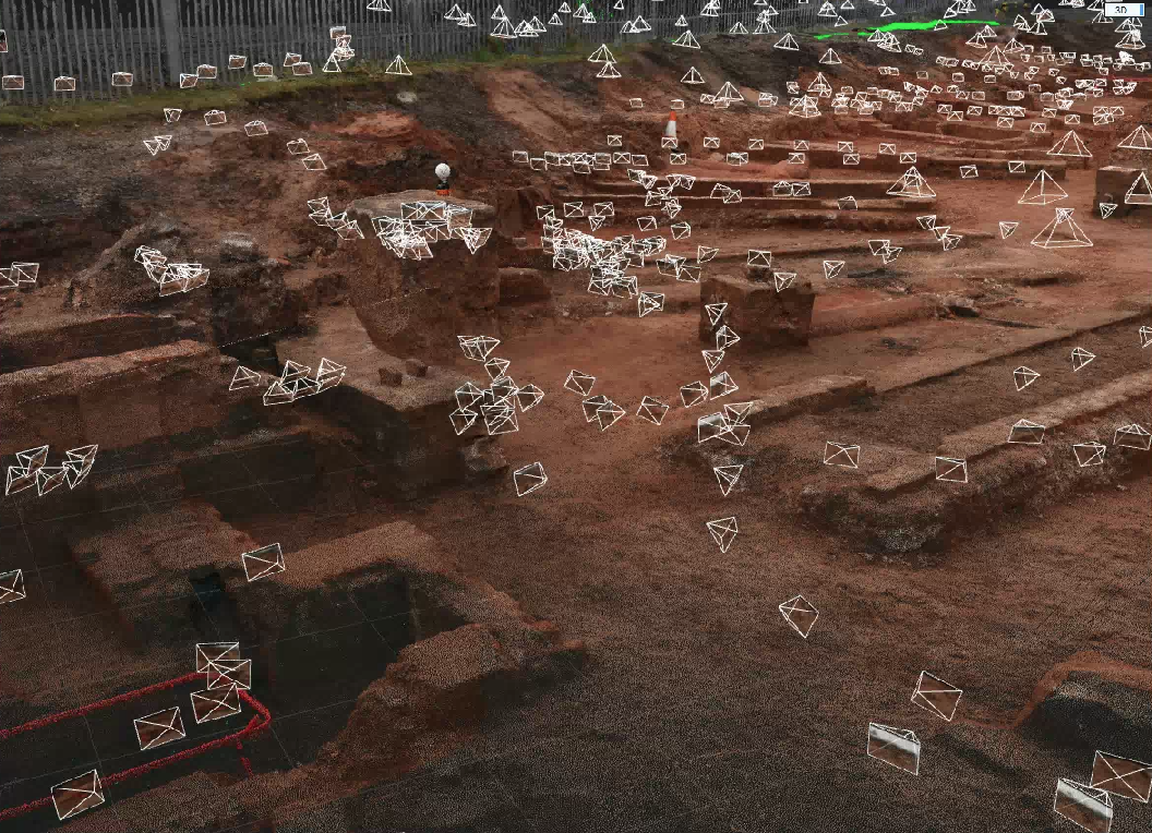
Digital documentation of the Roundhouse using SFM photogrammetry (Figure 3) provided a detailed and faithful historic record of this significant railway asset that provided the template for similar locomotive engine houses across the globe.
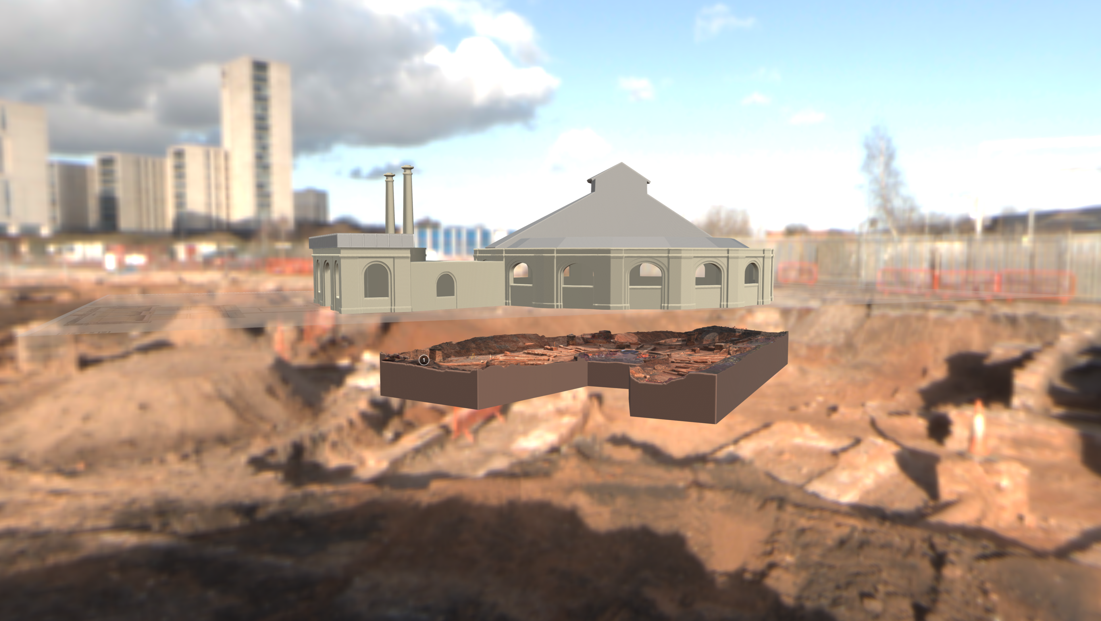
3D reconstruction was made possible using Blender which allowed for direct comparison between Stephenson's original drawings and the measured data collected on site through laser scanning and structure from motion photogrammetry (Figure 4). This resulting in an engaging and informative model for use in webinars aimed at both HS2 professionals and the wider public (HS2 in Focus 2020; Wessex Archaeology 2020; HS2 Festival of Archaeology 2021a). Significantly, it was reported that the use of 3D modelling for reconstruction and interpretation was responsible for an Historic England inspector 'completely changing their understanding of the design and evolution of the Roundhouse' (Millward 2020), particularly showing the change in roof after 1843 from an open-air ring form, to a domed structure (Sparrow 2020).
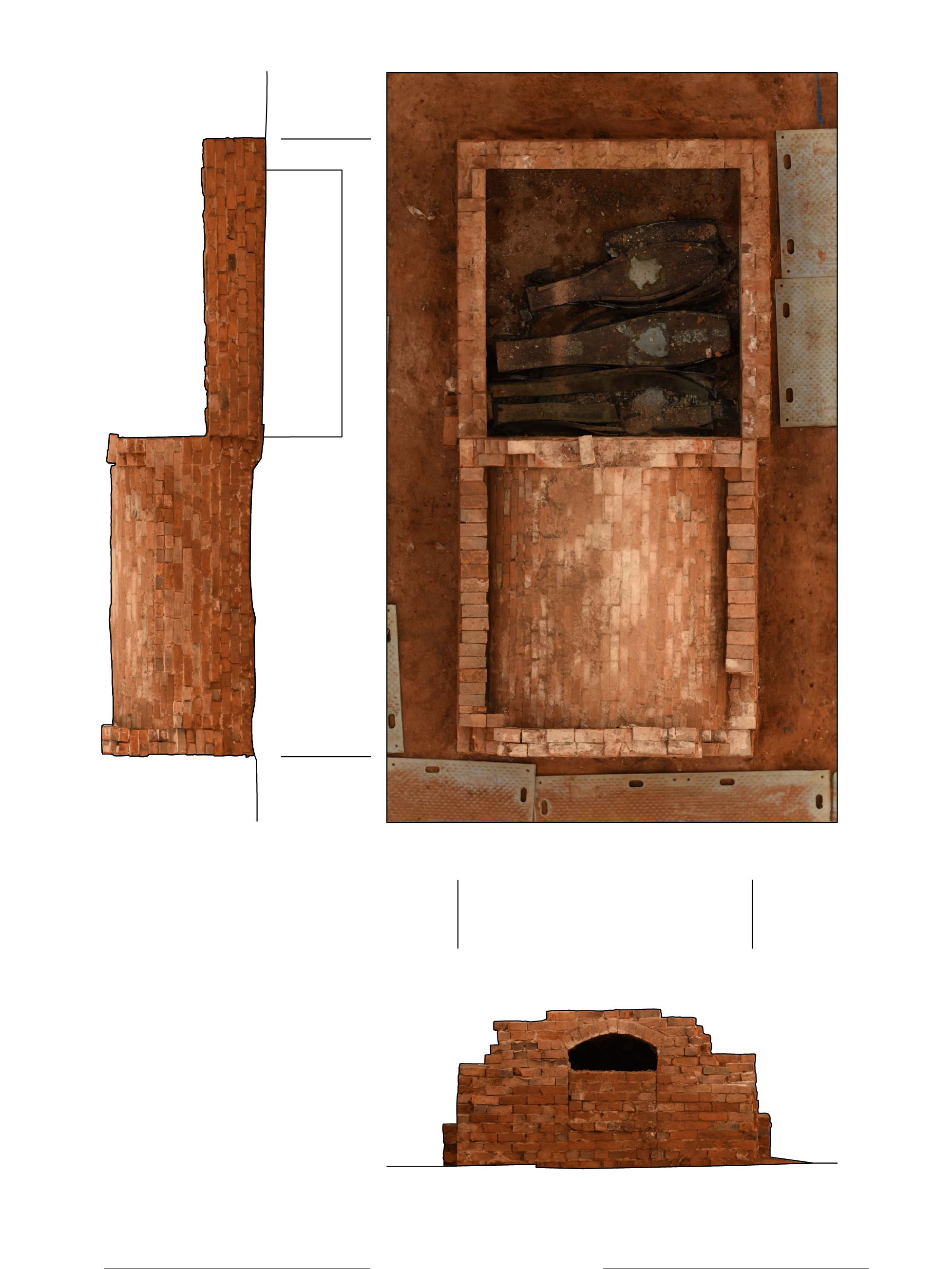
Further documentation of the infrastructure relating to the coke vaults was undertaken in February 2021. This involved the use of SFM photogrammetry, terrestrial scanning and mobile mapping, both above-ground and lowered into tunnels that supplied the boilers that operated the hydraulics mechanism (figure 5).
Access into the Principal Building was granted for the purpose of mobile mapping and 360 imagery for digital documentation. Interior mapping of the structure was possible with the exception of a few localities which had been sealed off following an asbestos survey of the building, prior to work to restore the building (HS2 2021b). Mobile mapping data offers a cutaway of the building, showing the grand staircase, and related features that can be compared to the original architectural drawings (Figure 6). This shows the intentional nature of structural features as built, inclusive of the staircase leading from the main entrance way.


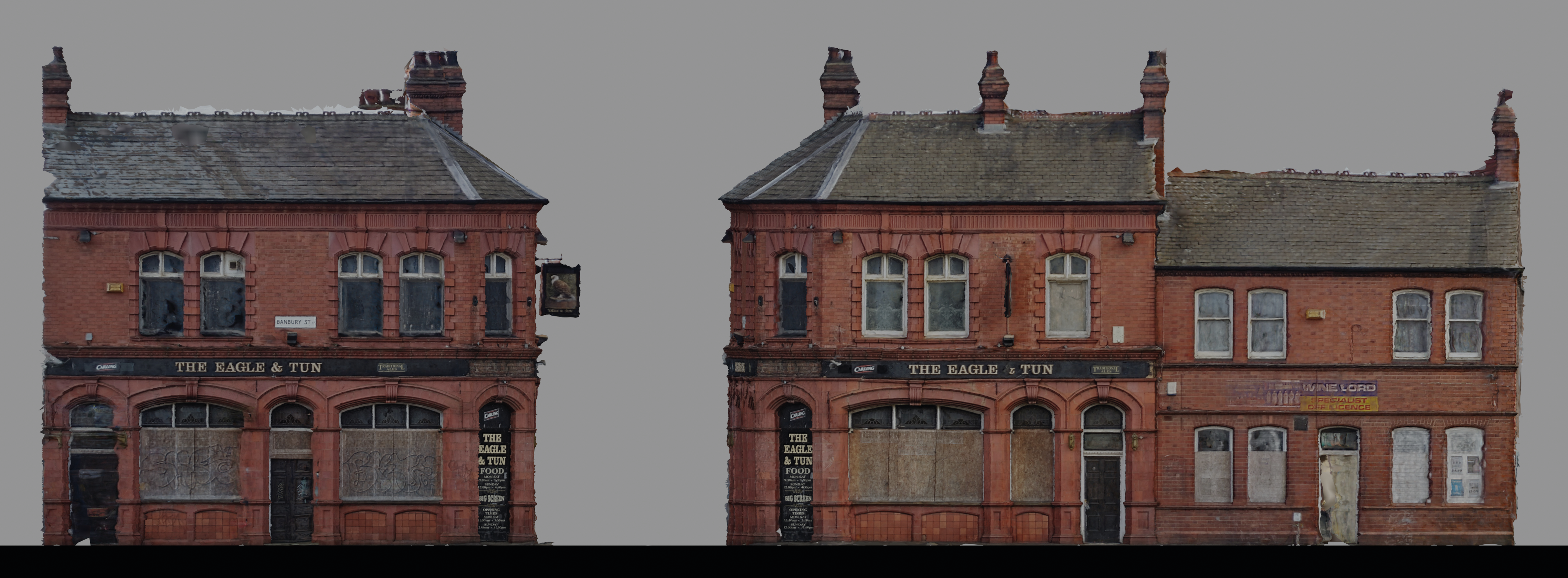
The locally-listed Eagle and Tun Public House is significant because it had been part of the cityscape for over one hundred and twenty years, standing at the corner of New Canal and Banbury Streets (Figure 7). Originally granted permission for construction in September 1899 (Birmingham History Forum 2023) it was built on the site of a former pub of the same name and despite a brief name change to become the 'Cauliflower Ear' in the 1990s, it had reverted to being called the Eagle and Tun by the early 2000s (Turner 2004). Beyond representing and important element of the social fabric of Digbeth, the Eagle and Tun also has significant connections with Birmingham's Music Heritage. Two music videos were filmed within the building – including 'Red, Red Wine' shot by UB40 in 1983, with the interior also featuring on the front cover of their 1987 'Best of UB40' album which included a compilation of songs recorded at the nearby DEP International Studio in Digbeth; the building also featured within Ed Sheeran's 2019 video 'Take me back to London', featuring Stormzy, Jaykae and Aitch. The decision to demolish the building as part of the enabling works was made public in 2018 and the pub finally closed its doors on 4th January 2020, ahead of demolition which began 7th October 2020.
A virtual model of the building, was reconstructed after demolition using methods developed as part of the Curious Travellers methodology (Wilson et al. 2022), used previously to reconstruct heritage assets that had been damaged through natural disaster and human conflict (Wilson et al. 2019). Extant imagery was sourced from photographic surveys undertaken by COPA (2020) following the fire in January 2020, and from Birmingham Museums Trust (December 2019) which were combined with imagery in the public domain that was web-scraped. SFM photogrammetry was used to develop a 3D model (Figure 8) and none of the donated or web-scraped images were reproduced or shared.
Land at Park Street was purchased in 1807 to serve as an overflow cemetery to St Martin's-in-the-Bull Ring (Brickley 2006). Targeted work was undertaken using mobile mapping, terrestrial laser scanning and SFM photogrammetry to record two brick-lined vaults (Figure 9) and individual earthen burials within the cemetery at Park Street during the process of excavation (Current Archaeology News 2019). This work was intended to complement and contextualise the programme of post-excavation assessment and analysis of human remains exhumed from Park Street cemetery in advance of the reburial programme for HS2 (Bradley 2021). The assemblage included a number of burials out of 6500 individuals that showed evidence of post-mortem craniotomy. The significance of this can be linked both to the rapid population expansion that Birmingham faced from the 1800s onwards, coupled with the establishment of medical schools within the city which created demand for cadavers for human dissections.
The key goal for data capture was to create a substantive legacy of heritage assets in advance of construction work for HS2. This involved recording the full extent of the Roundhouse by processing and combining datasets from March and June 2020 and February 2021, plus data supplied by MOLA-Headland and COPA for specific heritage assets, in order to produce orthographic projections and as 3D data to produce a working base model.
The work described within this paper covers research activities that were formulated as opportunities arose during enabling works. They sat alongside the programme of archaeological works at different locations linked to the new Curzon Street terminus, supported by data obtained through a number of different phases of the HS2 enabling works between 2019-2021. Bringing together these strands of information into an integrated narrative was complicated by the goals of different work packages. Opportunities were developed to complement a range of activities in conjunction with the design consultants, but the involvement of different joint-venture commercial archaeological consortia and varied drivers for individual work packages meant that some opportunities were not taken forwards beyond scoping work, or pilot data. It was not possible for instance to collate all survey and ground penetrating radar data in order to show related datasets connected with the location of the coke vaults, and other evidence of the Engine house for the Roundhouse, relative to our 3D data.
Proposals to capture data for a larger area of Digbeth to contextualise the site was informed by test data walking between Curzon Street and Fazeley Street, for which a data volume was estimated at approximately 500 MB per metre, based on roughly 1 metre per second walking rate. This helped to join the location of the enabling works at Curzon Street, with the former Park Street cemetery, and scaled data for the former Eagle and Tun public house, helping to place a virtual reconstruction of this back within its streetscape setting following demolition.
Undoubtedly, further work would collectively have helped to contextualise the surviving evidence of the early railway infrastructure, offering direct linkage to heritage assets within the wider historic environment and connecting people with place. Based upon proximity and relationship, these include: 1) the canal network comprising roughly 3 km canal towpaths (Fazeley Canal and Warwick and Birmingham Canal, part of Grand Union Canal) within the Digbeth, Deritend and Bordesley High Streets Conservation Area and the Digbeth Branch Canal to the north; 2) the public realm within Digbeth, Deritend and Bordesley High Streets Conservation Area to emphasise surviving evidence of industry and trades that utilised the railway network; 3) the land that encompasses the old goods yard and railway viaduct to the north of the Conservation Area, inclusive of the relationship of the Principal Building to evidence of the former Dockray's Hotel wing to the North and adjacent buildings, including the Eagle and Tun and Woodman pubs (Turner 2004; McKenna 2006), plus the Goods Shed and Top Yard north of Curzon Street.
To complement the scan data, 360 video and soundscapes were captured in March 2020 as the Roundhouse was being uncovered. This rich content provides clear insight into the process of excavation of the Roundhouse and when seen alongside the passage of present-day railway traffic on the adjacent mainline, these offer atmospheric content that ultimately help to raise awareness of the value of archaeological investigation as part of enabling works and the potential of this alongside 3D content as legacy content for rich immersive virtual tours. Proposals to scan and model a contemporary locomotive such as 'Columbine' (NRM object number 1975-7016), that had been designed and built in 1845 for the Grand Junction Railway by Alexander Allan at the newly opened Crewe works, were not taken up for the initial community engagement deliverables.
As HS2 enters the post-excavation service phase it is clear that the question-led approach informed by the HERDS will seek to maximise the potential of the excavation archive. Developments beyond use of projectional radiography and surface scanning techniques first employed with Digitised Diseases more than ten years ago (Wilson 2014) now afford opportunities to develop legacy with artefactual material and human remains. New technologies, including cone beam CT, micro CT capabilities and structured light scanning (University of Bradford 2022), coupled with increasing potential for throughput with largescale assemblages, offer scope for legacy. This can ensure that digital cross-sectional and surface image data provides unique information that complements insight into the health and disease of industrial-era Birmingham as examined through osteological evidence and biomolecular approaches.
The focus of this paper has been on the use of digital documentation methods to capture evidence both during excavation, and once fully exposed. The approach that was used sought to mitigate against loss of information, or adverse change to the archaeology and historic environment, recognising the fundamental benefit of retaining the physical fabric of heritage assets where possible, and framing the archaeological investigation process around advancing knowledge and understanding and generating 'value'. A particular function of the high-resolution spatial data and modelling is therefore to allow key stakeholders to return easily to the data and ask and answer new questions about the heritage asset.
Rapid capture was undertaken prior to the final decision to rebury Stephenson's Roundhouse, in the knowledge that ultimately the cemetery assemblages would be reburied. The methods for documenting archaeology and heritage assets at both Curzon Street and Park Street were selected in order to add to the interpretative value of the site through fusing datasets, data modelling and creation of immersive content.
Many options were considered for how to present this data as rich immersive content and the entirety of the combined content was developed for use in a variety of different ways - from the initial programme of webinars and virtual tours for public engagement, through to future legacy content for interactive/ immersive exhibition, interactive online resources and heritage trails using mixed reality modes of dissemination.
Quality assurance steps were incorporated into workflows to ensure that 3D data were post-processed to a high standard for interactive outputs before archival deposition. Creative Commons licensing (CC-BY-SA-ND) and use of the FAIR Guiding Principles (Wilkinson et al. 2016) is intended to facilitate widespread usage of the assets that have been created, with scope for further licensing possible on a non-commercial basis for not-for-profit community engagement purposes.
We would like to acknowledge and thank the role of partners at LM-JV (Laing O'Rourke and J. Murphy and Sons), Mary Nicholls from Design consultants WSP-JV, colleagues at Headland, Don Walker at MOLA, COPA (Cotswold, Oxford and PreConstruct Archaeology), Wessex Archaeology and others, including Jez Collins at Birmingham Music Archive as part of this research that stems from the enabling works for HS2.
Content will be deposited with the Archaeology Data Service in York, in accordance with data strategies from related archaeological recording, as with data from the former Curzon Street Station Yard.
The authors would like to acknowledge infrastructure support from the Arts and Humanities Research Council (AH/V01255X/1) for 'Capabilities for Human Bioarchaeology and Digital Collections'. For the purposes of open access, the authors have applied a Creative Commons Attribution (CC BY) licence to any Author Accepted Manuscript version arising from this submission.
Internet Archaeology is an open access journal based in the Department of Archaeology, University of York. Except where otherwise noted, content from this work may be used under the terms of the Creative Commons Attribution 3.0 (CC BY) Unported licence, which permits unrestricted use, distribution, and reproduction in any medium, provided that attribution to the author(s), the title of the work, the Internet Archaeology journal and the relevant URL/DOI are given.
Terms and Conditions | Legal Statements | Privacy Policy | Cookies Policy | Citing Internet Archaeology
Internet Archaeology content is preserved for the long term with the Archaeology Data Service. Help sustain and support open access publication by donating to our Open Access Archaeology Fund.
 Home
Home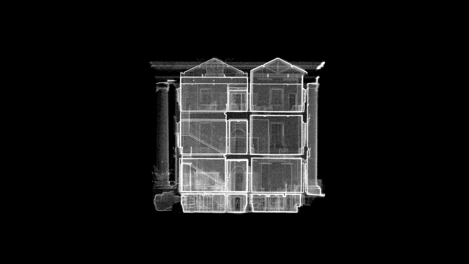