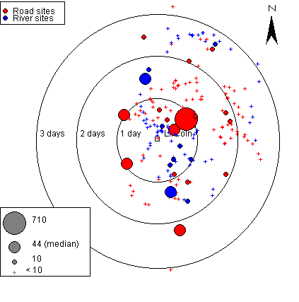
This map represents the time-distance maps discussed in the text. It demonstrates the distribution of Lincoln wares according the time it would take to travel from Lincoln to each site. Days are marked on the map as a time scale. Days are measured as 8 hours of travel.

The reader can explore the distribution of Lincoln wares via both river and road through the toggles in the Control Panal. The reader can also choose only to look at those sites with more than ten pots or to view the entire distribution. Sites with less than ten pots are represented by crosses.
The data was compiled from the East Midlands Anglo-Saxon Pottery Project database (Vince and Young 1991) with permission from Dr. Alan Vince and Jane Young. This database is continually being updated. Queries regarding the most current data should be directed to Dr. Alan Vince or Jane Young (Write to: 25 West Parade, Lincoln, LN1 1NW, UK). This data is structured to represent the maximum number of pots.
Additional help is available from within the applet itself.
miniGIS Java applet
Version 1.0
Research and Design ©Leigh Symonds 1995-2002
Coding and Implementation ©Rik Ling 2002