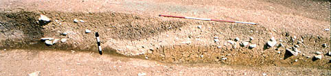
Image: B-A2-25
Location: Site B, Area 2, Drawn as section 4
Plan of Saxon features | Plan of Medieval features | Plan of Site B
Aspect: View looking E
Section through the deposits on the front of the bank and berm, south defences (section 4). The clay bank and dark turf revetment is to the left (N), with a few of the lowest stones at the rear of the wall in situ. The light-coloured deposits from the destruction of the wall form a pile of a mixture of mortar, rubble and stones, which to the S (right) form marked tip lines at the far edge of what must have been a substantial pile on the berm. These would have tipped into the ditch, off the frame to the right, shown in photo 2/35 (though here removed by the excavation of the ditch of period 4). The hollow in the original subsoil, to the right of the vertical ranging pole, marks the position of the foundation trench for the bottom front row of stones of the wall. The destruction deposits are cut by the palisade trench of period 4, at the position of the vertical ranging pole. For oblique views of this trench, looking from the SW and NW, see photos 2/35 and 2/27.