Image: B-A2-39
Location: Site B, Area 2
Plan of Saxon features | Plan of Medieval features | Plan of Site B
Aspect: View looking S
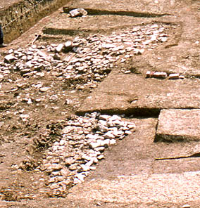
Detail of photo 2/23, showing the area behind the bank, which included the intra-mural walkway, in course of excavation. The latter is partly revealed in the foreground, and the corner uncovered top right. The dirty clay deposit overlying the walkway (and partly removed along its line) - lower left corner - contains large stones which are strewn over a wide area behind the bank, and in the same layer overlying the stones of the walkway. It is suggested these stones were derived from the destruction (period 3) of a dry stone wall along or behind the crest of the bank, added in period 2.