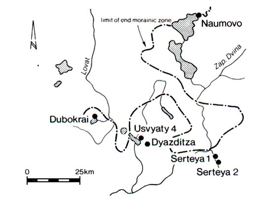
Figure 2: The Upper Western Dvina basin. Black circles: prehistoric lake-dwellings
The Serteya is a small tributary of the Western Dvina River, 20km east of the town Velizh and c. 100km north-north-west of Smolensk, the provincial capital. This area lies immediately south of the limit of the terminal morainic zone of the Last (Valdai-Weichselian) glaciation (Fig. 2). The surrounding terrain forms an evenly undulated sandy glacial outwash plain at the altitudes of 150-180m, with isolated occurrences of morainic landforms (Malakhovsky and Markov 1969).
Figure 2: The Upper Western Dvina basin. Black circles: prehistoric lake-dwellings
The Serteya's narrow valley widens in two places, one in the north and one in the south (Fig. 3). As will be shown later, during the Holocene this entire valley was taken up by the lakes that were drained during the subsequent development of the Western Dvina catchment.
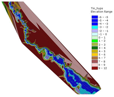
Figure 3: Serteya Valley (GIS 3-D projection)
Starting with the maximum advance of the Valdai (Weichselian) ice-sheet at 20-18 ka, a system of ice-dammed lakes encompassed the entire catchment of the Upper Western River (Kvasov 1975). Their shorelines are visible at the heights ranging between 180 and 130m. This system collapsed following the abrupt fall of the Baltic Ice Lake at 11,560 cal years BP (Agrell 1979; Andren et al. 2002). The lakes that existed in the Serteya valley were the remains of a huge ice-dammed basin.
The present-day climate is moderately continental, with mean temperatures of -8°C in January and 17-18°C in July, and precipitation of 500-700mm, mostly in summer. This area belongs to the East European mixed broadleaved-coniferous forests. Temperate deciduous formations consist of mixed oak forests, which are found mostly on the clayey soil of the morainic hills. Boreal evergreen conifer (mostly pine) forests cover the sandy outwash plain. Spruce forests are usually restricted to the lower levels of the morainic hills. An intensive felling of forests started in the 13th-14th centuries and was much increased after the 1860s. The woodland currently occupies less than 20% of the originally forested area. The secondary forests consist of birch, and alder with shrubs. Bottomland floodplain meadows, bogs and mires occupy about 40% of the total area. Agricultural plots take up the remaining 40%. Main staple crops are rye, wheat and flax.
© Internet Archaeology/Author(s)
University of York legal statements | Terms and Conditions
| File last updated: Wed Dec 15 2004