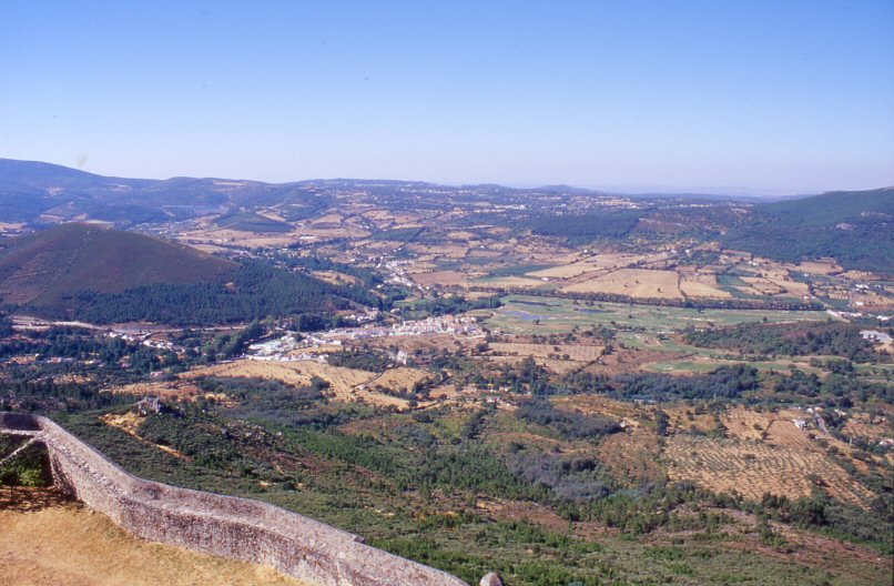
Figure 1: Elevation of Marvão, showing the location of the study area
The ruins of the Roman town of Ammaia are located in the heart of the Natural Park of the Serra de São Mamede, a mountainous area of east central Portugal extending into Spanish territory. The site is part of the fertile valley of São Salvador da Aramenha in the municipality of Marvão, district of Portalegre, within the region of Alto Alentejo.
Figure 1: Elevation of Marvão, showing the location of the study area
The Alentejo is a very rural region. The population number is low, there are several small towns but very few big cities, and farms with large estates are dispersed throughout the landscape. A great part of the sparse population still makes a living from agriculture, which is dominated by cork and olive plantations and pastureland. The majority of the Alentejo consists of outcropping hard rocks, which means that the resultant soils are very shallow, evidently making them very poor. This is exacerbated by the extreme summer dryness, especially in the south, due to Mediterranean influence. The only ways of using the land are consequently grazing for meat production (mainly cows) and cork/olive production (trees which make few demands on the environment).
Portalegre is the northernmost district of the Alentejo region and it is also the name of the district's capital town. Another name for the district is Norte Alentejano (the north of the Alentejo). It is the hilliest part of Alentejo and hence forms a transition between the lower parts of Alentejo in the south and the mountainous Beira in the north. It is characterised by a desolate landscape of rolling planes in schists and granites, alternating with quartzite hills. The Serra de São Mamede is the main mountain range; it has a NW-SE orientation and extends for some 40km, distributed more or less equally between Portugal and Spain. The highest point is the Pico de São Mamede at 1027m above mean sea level. This elevated area forms a real barrier for clouds, which cause abundant orogenetic rains, resulting in numerous rivers and streams. The whole mountain range is encompassed in a protected natural area: the Serra de São Mamede Natural Park. The main rivers of the area are Ribeira de Nisa and Rio Sever, roughly running SE-NW along the same orientation as the main mountain ridges, and of course the River Tejo, to which the aforementioned streams are tributary. Throughout history several rather small dams have been built on these rivers, mainly for water storage.
The Portalegre district has an extensive cultural patrimony. Remains of many time periods can be found throughout the area. More than 500 dolmens and menhirs dispersed throughout the area witness prehistoric human occupation, as do the numerous artefacts of lithic industries that have already been found on the Tejo's river terraces. Roman remains are very abundant, as are medieval remains. Several hilltop villages with castles (e.g. Portalegre, Castelo de Vide, Marvão) testify to the area's potential for the construction of defence sites (N.N. 2001).
The archaeological and historical identification of the site as the Roman town of Ammaia dates from the mid-1930s (Vasconcelos 1935, 5). Systematic archaeological digs started here only in 1994, and from 1997 this work of excavation, study and conservation has been organised by the Fundação Cidade de Ammaia. These excavations were all centred on places where still visible ruins indicated the underground presence of Roman and Late Antique building structures. They mainly consist of parts of the Roman city wall with towers and a gate ('porta sul') on the southern side, remains of housing and a monumental paved square and road in the same sector, remains of a house in the location Quinta do Deão, parts of a public bath building and the remains of the centrally located forum with the well-preserved podium of a temple and walls of a surrounding porticus or cryptoporticus (Fig. 8). So far only very preliminary excavaton reports have been published (see Oliveira et al. 1996; Pereira et al. 2000; Borges 2003.
Apart from providing the first good indications about the extent and organisation of the former urban area, these digs, in combination with the first topographic mapping effort and a synthesis of earlier historical, epigraphic and numismatic evidence, inform us about the location of the town and the major elements of its chronological development (for syntheses of earlier historical and archaeological work about Ammaia, see Guerra 1996 and especially Mantas 2000).
Founded probably in the 1st century AD, at the latest under the reign of Claudius (Note 3), the flourishing Roman town, lying in the Roman province of Lusitania, soon received municipal status (under Vespasian?) and developed its urban structures in part as a result of the efficient exploitation of the area's natural resources: metals and minerals (e.g. lead, silver, rock crystal), fertile agricultural land, horses etc. (Alarcão 1988a; Alarcão 1988b; Guerra 1995; Mantas 2000; Carvalho 2003). A further major asset was its location on the junction of several main roads, one of which connected Ammaia with the provincial capital of Emerita Augusta (Merida) (Mantas 2004; Carvalho 2003).
After the 5th century the city seems to have fallen into ruin and the recent excavations (Pereira et al. 2000) showed that some parts were covered by floods and slope deposits. Under Arab rule the Roman site was finally abandoned, to be replaced in the late 9th century by the nearby and strategically well-situated town of Marvão (Note 4). During and after the later medieval period, the above-surface ruins were further dismantled. With the exception of a few separate wall structures mentioned above, not much of this classical town remains visible today.
The archaeological site of Ammaia is located on a hillside immediately south of the small 'street-village' of São Salvador da Aramenha, near the Rio Sever.
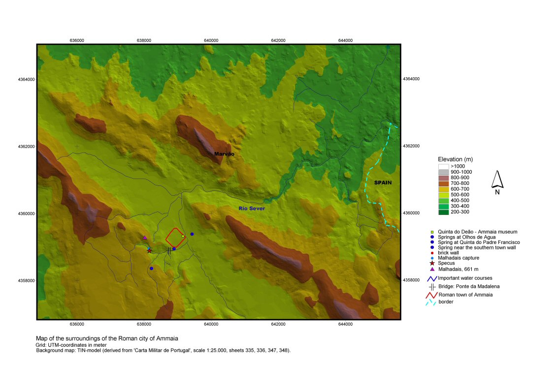
Figure 2: Topography of Ammaia and surroundings. The main archaeological features discussed in this article are present. [View static image]
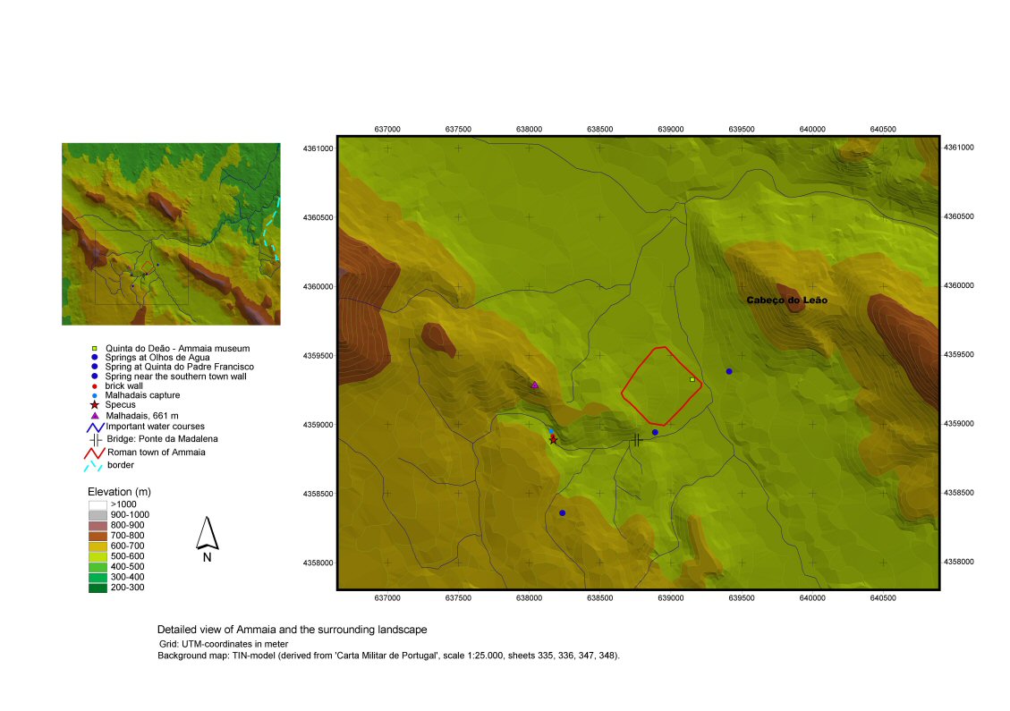
Figure 3: Topography of Ammaia and surroundings (detail). [View static image]
Nowadays this terrain is almost completely used for agricultural purposes, mainly olive and some crop cultivation. The upper parts of the hillside are covered by light woodland and abandoned cultivation terraces. Except for a handful of houses and farms, one of which (the farm house at Quinta do Deão) was recently transformed into an attractive archaeological museum, the site is almost free from modern building constructions. It is, however, cut into two unequal parts by the national road (no. 359) leading from Castelo de Vide to Portalegre.
The exact extent of the ancient territory of Ammaia remains unknown, but it was no doubt considerable, extending to the north up to the River Tejo and to the east deep into modern Spain. It probably formed an area of about 60 by 60km, with Ammaia as its central focus (Mantas 2000). The town lay in a hilly landscape, geologically dominated by quartzites and schists, surrounded by an extensively undulating to sometimes nearly flat landscape of granites. The topographical situation of the town is no doubt linked to the presence in this hilly environment of the Holocene valleys of the Rio Sever and of a main tributary descending from the north-west, from the area of Castelo de Vide. The abundance of natural water springs in the area was clearly an extra attraction for the Roman settlers. The impressive historical hilltop site of Marvão, located some 2.5km north of the Roman town site, visually dominates the landscape. Its role as a possible predecessor of the city of Ammaia must certainly be taken into consideration, although there is no conclusive evidence for this today. Recent surveys in the area north of the urban centre of Ammaia, show a quite intense dispersion of Roman farms and farmsteads in the immediate hinterland of the town (Carvalho 2003, 73). They certainly illustrate the Roman Imperial success of the urban centre in exploiting its hinterland.
© Internet Archaeology/Author(s)
University of York legal statements | Terms and Conditions
| Last updated: Mon Nov 21 2005