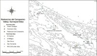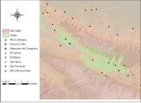
Figure 20: Sites surveyed at the Redención del Campesino valley

Figure 20: Sites surveyed at the Redención del Campesino valley
During the 2003/04 field season 30 sites were surveyed (Fig. 20), many of which had been previously recorded between 1985 and 1987 by the Proyecto Atlas Arqueológico carried out by the National Institute of Anthropology and History of Mexico (INAH). The survey transects were established on the basis of the predictive model results and the proximity to the trails that may have been used in antiquity as routes of communication. Additionally, surveys were conducted on a community-by-community basis, taking advantage of the local knowledge as well as the support of the communal authorities. Four of the visited sites (Santa Rosa, Agua Sucia, San Arturo, and Álvaro Obregón 2) lay in relative proximity tof the high potential areas identified by the Dempster-Shafer method.
The information gathered during the archaeological survey of the Redención del Campesino Valley, and the Proyecto Atlas Arqueológico constitutes the basis of the site hierarchy scheme presented. This takes into account number of structures, and quality of architecture (Table 1), as well as the actual location of the sites within the valley. In this context three sites dominate the landscape: Redención del Campesino, Álvaro Obregón 2, and El Tigre. For reasons that will be outlined, I consider the first two to be equivalent to secondary sites such as Panhalé, La Pasadita, or La Mar, while El Tigre may represent an outlier of Álvaro Obregón 2 and may have been exclusively an administrative centre.
| Name | Number of structures | Dressed masonry | Vaulted structures |
|---|---|---|---|
| Redención del Campesino | 30 | Yes | No |
| Alvaro Obregón 2 | 20 | Yes | Yes |
| El Tigre | 17 | Yes | No |
| El Tinaco | 16 | No | No |
| El Camino | 14 | No | No |
| San Fernando | 12 | No | No |
| Las Lomas | 11 | No | No |
| Los Corrales | 11 | No | No |
| El Milagro | 11 | No | No |
| San Arturo | 10 | No | No |
| La Union | 8 | No | No |
| Doña Salud | 8 | No | No |
| Ignacio Allende | 7 | No | No |
| La Antena | 6 | No | No |
| Alvaro Obregón 1 | 6 | Yes | No |
| El Mangal | 5 | No | No |
| Los Frutales | 5 | No | No |
| Francisco Ortiz | 4 | No | No |
| Camino a San Marcos | 4 | No | No |
| Bejucal | 4 | No | No |
| San Antonio | 3 | No | No |
| La Parcela | 2 | No | No |
| Agua Sucia | 2 | No | No |
| Santa Rosa 2 | 1 | No | No |
| Margarito | 1 | No | No |
| Reforma Agraria | 1 | No | No |
| Santa Rosa 3 | 0 | No | No |
| La Mensura | 0 | No | No |
| Camino Viejo | 0 | No | No |
| Rogelio García | 0 | No | No |
| Corral de Don Braulio | 0 | No | No |
| Santa Rosa 1 | 0 | No | No |
Several sites within the Valley are recorded as having 10 or more structures, but for the most part these are low mounds and platforms built with undressed stones and packed dirt. Only San Arturo warrants its consideration as a third-level site. Outside the valley, El Camino, El Milagro and San Fernando also fall within this class. The remaining sites were classed as fourth- or fifth-order sites that more likely represent rural outliers of the bigger centres.
It became apparent that the central location of Redención del Campesino offered a definite advantage in terms of access and control of the main communication routes. Interestingly, although Redención del Campesino is the biggest centre in the valley and contains the greatest amount of masonry structures, no clear evidence of vaulted buildings (an expected feature in a political/ceremonial centre of any relevance) was observed. It is pertinent however to point out that based on an initial assessment, the ceramics observed at the site reflect a longer occupation history, suggesting a site growth from west to east, thus the actual limits of the site are likely to have varied through time.
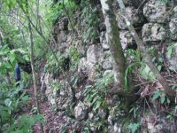
On the other hand Álvaro Obregón 2, albeit being smaller in extent compared to Redención del Campesino, represents the only site surveyed in the valley with unmistakable evidence of vaulted buildings and monumental platforms constructed with massive well-dressed blocks (Fig. 21).

Figure 21: Monolithic platform located at the site of Álvaro Obregón II
The position of Álvaro Obregón 2, as in the case of Panhalé, provides a commanding view of the valley and potentially, Redención del Campesino would be visible (Fig. 22). Furthermore, the very steep slopes surrounding this centre give it a definitive military advantage, particularly during the belligerent times that characterised the Late Classic.

Figure 22: Area visible from Álvaro Obregón II
It is important to note that although the hard to reach location of Álvaro Obregón 2 hinders its function as the administrative centre of the valley, this was definitely an important centre within the valley. The possibility that this site constituted the administrative hub of the valley is unlikely; Redención del Campesino is in a much better position to claim this status. Nevertheless, it is on the basis of its very location that I propose that this site was indeed the seat of the local ruler, especially in troubled times when a centre of this nature may have offered safe haven to a besieged nobility.
© Internet Archaeology/Author(s)
University of York legal statements | Terms and Conditions
| File last updated: Tue Mar 7 2006