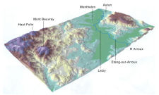

Figure 6: Topography of the study area
Figure 7: View across the valley looking towards Autun, with hills behind
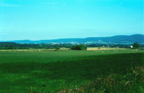
Figure 8: The valley of the Celle
The Arroux valley study area straddles the junction of two distinct geological entities. To the north-west is the Morvan massif, formed from crystalline rocks and rising to a maximum height of 901m at the Haut Folin and including Mont Beuvray (821m) among its other prominent peaks. To the south and east of the river are granitic uplands, which prolong the Côte d'Or, never as high as the Morvan but nonetheless reaching heights of over 500m or occasionally 600m in places. Separating these two areas of upland is a basin coinciding with the syncline of the Autun coalfield, traces of the extraction of which can still be seen in the form of slag heaps north of the modern town. At its lowest point the basin lies just less than 300m above sea level.
Flowing through this basin on its way to join the river Loire is the river Arroux. From Autun, it flows south-west for 8km before turning due south for a further 6km to the small town of Etang-sur-Arroux. The river skirts the northern edge of the granitic plateau so that on its left bank the ground rises steeply and is generally heavily wooded. On the right bank, however, the terrain opens out into more rolling countryside, attaining a maximum width of 5 or 6km before the ground starts to rise again towards the Morvan. At the centre of this flatter area is the modern village of Monthelon, which gives its name to the first commune west of Autun. A number of smaller streams and tributaries of the Arroux flow through this area, forming a series of side valleys. The most important of these streams are the Celle, on which the village of Monthelon stands, and the Méchet, which rises at Mont Beuvray 13km away.
Figure 6: Topography of the study area
Figure 7: View across the valley looking towards Autun, with hills behind
Figure 8: The valley of the Celle
Within the southern part of the Autun basin (corresponding to the communes of Autun and Monthelon), the Arroux and its tributaries have laid down an extensive series of alluvial deposits (silts, sands and gravels, but also pockets of coarser granite and quartzite pebbles, cobbles and larger rocks), masking the underlying Permian geology. Bordering the principal watercourses is a low alluvial plain up to 1-2km in width, beyond which lie areas of higher terrace (Figure 13: fluvial deposits - Fx) up to 10-15m in height. It is difficult, however, to distinguish between the lowest terrace (Fy) and the floodplain proper (Fz) since the difference in height is small. Close to the junction of the Méchet and the Arroux, beside a granitic outcrop known as Beaufort, where the Arroux enters the commune of Laizy, the river valley begins to narrow. Here, the alluvial deposits are confined to an area less than 1km wide on either side of the river, beyond which they give way again to granitic rocks on both banks.
The whole area is covered by silty loam soils varying in depth from a few cm to 1 or 2m, rich in quartzo-feldspathic inclusions, for the most part used as pasture. Apart from Monthelon and Laizy, there is little modern settlement in the area, which is given over to a scatter of individual farms and accompanying labourers' cottages; the overall density is no more than two per square kilometre. In a few cases, it appears that the larger farms are the remains of more sizeable settlements, for example, at Chazeu beside the river to the south of Laizy, where the modern farm stands next to the ruins of a medieval castle; at Chevannes, on the flank of Beaufort hill; and at Chantal in the Celle valley north of Monthelon.
The main roads running through the area are the RN 81 from Autun to Bourbon-Lancy and the D 994, which forks off the main road 3km south-west of Chevannes in order to follow the right bank of the Arroux to Etang-sur-Arroux, where it crosses the river, before continuing to Toulon-sur-Arroux and Gueugnon, both of them important Roman settlements. It is thought that both modern routes follow the line of earlier Roman roads running south-west from Autun, which crossed the river at Autun in order to take advantage of the relatively flat ground on the right bank of the river as far as possible. However, the precise route of the Roman roads out of Autun is unknown, although after it leaves the valley the alignment of the road to Bourbon-Lancy appears to be picked up by a series of field-boundaries and trackways. Besides Autun, there are several other well-established fords and river crossings along this stretch of the Arroux, notably at Etang-sur-Arroux, Laizy - both of which now have bridges - and not least near Chevannes Farm, close to where the Arroux makes its junction with the Méchet, which is often suggested as an old route from the river valley up Mont Beuvray.
Over the years, there have been sporadic casual finds of Roman material in and around the modern villages of Etang-sur-Arroux, Monthelon and Laizy, while a number of Roman cemeteries are known beside the RN 81 and the other Roman roads leaving Autun (Rebourg 1993). Just across the river from the city, on what may previously have been an island (La Genetoye), is the well known Gallo-Roman 'temple of Janus', set within a rectangular ditched enclosure and forming part of a more extensive Roman complex that also included a theatre; nearby at Pierrefitte are the remains of a Middle Neolithic causewayed camp found by René Goguey in aerial reconnaissance (Rebourg 1993, 30, 101). Some villas are known from 19th-century investigations, notably at Chantal in Monthelon (Rebourg 1993, 210) and at Buisson, in La Grande Verrière (Rebourg 1994, 414-15). Tin sources in the granitic hills overlooking Autun were evidently extracted from at least early Roman times (Cauuet and Boussicaut 2006) and there is also increasing evidence for the exploitation of the rich mineral resources of the Morvan at this period, if not earlier (Cauuet and Támas 2005).
As already indicated, the modern land use throughout the Arroux valley is mainly as summer pasture for cattle, with smaller areas given over to woodland and for growing barley and maize as animal fodder. In all, less than 5% of the area is under cultivation and these are almost invariably the same plots, apart from occasional ploughing of pasture fields for reseeding. The crops are harvested in early summer and early autumn respectively and, after harvest, both barley and maize fields are normally turned and re-sown within a few weeks, necessitating separate fieldwalking seasons in August and October respectively. These plots are almost never deep ploughed, or left to weather long enough for archaeological material to reach optimal visibility on the surface, limiting the possibilities for surface collection and retrieval.
© Internet Archaeology/Author(s)
URL: http://intarch.ac.uk/journal/issue25/3/3.html
Last updated: Wed Oct 29 2008