Figure 1: Site location in the centre of Sheffield
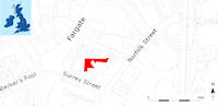
This article presents the results of a programme of commercial archaeological work undertaken in 2006 by Archaeological Research and Consultancy at the University of Sheffield (ARCUS), in the yard to the north and west of the Upper Chapel, Norfolk Street, Sheffield (Fig. 1). The work was undertaken ahead of a major redevelopment of the site and the environs of Carmel House, a suite of offices and retail units fronting onto the Fargate shopping area, and was required by the South Yorkshire Archaeology Service (SYAS) in line with government planning policy guidance (DoE 1990).
Figure 1: Site location in the centre of Sheffield
The site of Carmel House, and the adjoining land to the rear of Norfolk Row, had been subject to several phases of archaeological work. An archaeological desk-based assessment was submitted to Sheffield City Council (May and Jessop 2003), followed by a building appraisal of Carmel House (Jessop and Roberts 2004) and subsequent building recording of Carmel House (Duckworth and Jessop 2006). An archaeological evaluation of Pepper Alley, the access lane behind Carmel House, was carried out before demolition of the building (Bell 2005), with additional archaeological evaluation and mitigation work carried out following demolition of Carmel House, and buildings to the rear (Baker 2006). Copies of these unpublished technical reports were lodged with the Sites and Monument Record maintained by SYAS, at Howden House, Sheffield.
The earliest known map of Sheffield, produced by Ralph Gosling in 1736, depicts the town prior to its late 18th-century expansion (May and Jessop 2003). Gosling's map indicates that the medieval layout of the town was largely preserved at this date, with Prior Gate (later the High Street) linking the castle and market to the Anglican parish church of St Peter and St Paul (later to become Sheffield Cathedral). Fargate appears to have been part of the medieval town, an extension of Prior Gate, with tenements lining the street frontage and gardens behind. The Upper Chapel is shown, with a burial ground surrounding it. The chapel, originally a Nonconformist meeting house, was constructed in 1700 and had a congregation of c. 1,000 individuals, around one-sixth of the population of Sheffield at that time. The chapel is reputed to be the earliest brick-built building in the town, but has been extensively remodelled over the last 300 years. Much of the present-day fabric dates from an episode of rebuilding in 1847-1848, when the chapel was refurbished and access, which was originally from Fargate via Pepper Alley, was switched to the opposite side of the chapel to overlook open fields.
Details of the buildings between Pepper Alley and the proposed Norfolk Row, which was constructed between 1780 and 1789, are shown on a Fairbank plan of 1780, depicting large buildings fronting onto Fargate, with a few smaller structures to the rear and facing Pepper Alley, and the remainder of the area occupied by yards and gardens. Fairbank's plans of Pepper Alley show the south-east end of the street as 'Chapel Yard' or 'Chapel Walk' where it goes past the Upper Chapel and its graveyard. The name Pepper Alley probably comes from Dennis Pepper, who owned the land in 1767. Fargate was originally a narrower street and was enlarged between 1850 and 1890, cutting through an area of tenements between Fargate and Norfolk Street. The widening of Fargate removed a significant portion of the street frontage. Carmel House was completed by 1903, during a further period of rebuilding between 1890 and 1905.
Burial records held by Sheffield Archives relating to the Upper Chapel comprise 19th-century burial registers and a copy of monumental inscriptions. The comprehensive burial register (UCR 1/3) covers the period 1837-1854 and shows the annual number of inhumations diminishing over the course of the 19th century, with 13 recorded in 1837, 6 in 1847 and 3 in 1854. This trend is perhaps the result of a lack of space within the chapel precincts combined with the opening of the General Cemetery for Nonconformists in 1836, and is likely to have been accompanied by an increase in selection when determining the allocation of burial plots. The lack of burials after 1854 may be explained by the passing of the 1855 Burial Grounds Act, which prevented further interment within inner city cemeteries. The Upper Chapel's burial registers were inspected as part of the archaeological investigations. The registers comprise a series of notebooks containing simple numbered lists with names, dates, with occasional highlighting to identify interrelations within family plots. Unfortunately, they do not have accompanying plans showing the locations of the grave plots that are listed.
Before fieldwork began, two historical plans that show details of the chapel and burial ground were examined. A plan for the chapel authorities dated 1846, shortly before the construction of a vestry in 1848, shows burials in the area of the proposed vestry, with nine marked graves representing all ages, from infants and adolescents to the middle-aged and elderly. Inscriptions indicate that these interments dated from the first quarter of the 18th century, with the earliest interment being that of an infant, in 1723. A second plan, completed for the chapel authorities c. 1900 by the Flockton and Gibbs architectural practice, marks the location of 163 numbered grave plots throughout the chapel grounds, but once again these numbers cannot be linked to entries in the burial registers.
© Internet Archaeology/Author(s)
University of York legal statements | Terms and Conditions
| File last updated: Wed Jan 19 2011