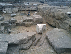
Figures 76 and 77: View of the northern stylobate, showing the superimposition of floors and steps belonging to different phases.
Already in the preliminary stages of the new work at S. Omobono, it became clear that the lack of a formal study of the development of the site, as well as inconsistencies in the identification of structural elements in the available publications and archival documents, would necessitate a thorough documentation of surface features in the area. Thus, in order to lay the groundwork for future fieldwork, over 450 stratigraphic units were identified, recorded and grouped structurally over the course of the 2009 and 2010 seasons.
Whenever possible, architectural 'layers' were distinguished on the basis of construction technique, material, orientation, or a combination thereof. Each unit identified in this way was assigned a distinct number, photographed, encoded graphically in an AutoCAD plan of the site, and documented with a new series of section drawings. Additionally, the distinguishing characteristics of each unit and its physical relationships to other structural elements were recorded in a digital database. This extensive body of information is now being synthesized graphically within a conventional Harris matrix for the entire site (for an introduction to the stratigraphic documentation of structural remains, see Brogiolo 1988).
This process of documentation of visible features, enabled by the thorough cleaning of the site conducted at the beginning of the 2009 season, has been instrumental in formulating a detailed research plan for the ongoing fieldwork and directing conservation efforts to particularly threatened areas. Nevertheless, as expected from the onset, the lack of detailed publications and updated plans from previous campaigns with which to correlate the database from the 2009 and 2010 fieldwork has hindered progress in the phasing and interpretation of visible features of the temple platform and the surrounding structures.
Adding to these problems, unrecorded conservation efforts and the repositioning of structural elements throughout the site have significantly obscured the stratigraphic relationships between key components of the complex. Taking advantage of the fact that most structures are built of ashlar (or in any case drystone) masonry, previous excavators rearranged blocks, floor slabs, and even columns and altars after their first exposure. Their aim was to integrate and recompose the visible architectural features, often on the basis of reconstructive hypotheses that were not clearly articulated or adequately justified; the result visible today is a patchwork of decontextualized structural elements.
Figures 76 and 77: View of the northern stylobate, showing the superimposition of floors and steps belonging to different phases.
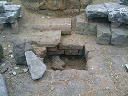
Moreover, the accumulation of debris throughout the site since the 1930s has complicated the interpretation even of elements that appear to be in situ. One such stratigraphic ‘puzzle’ of particular interest was encountered in the west-central sector of the temple platform, next to the southernmost of the two foundation courses (stylobates) of tufo blocks in front of the cellae of the twin temples (Figure 72). At various points along the southern limit of this stylobate lie several blocks of a different type of tufo pertaining to at least two rounded steps, and between extant sections of these blocks are additional paving slabs of a third type of tufo, also seemingly in situ (Figure 76; Figure 77). Taken together, these sparse elements suggest at least one otherwise undocumented restoration of the temple complex between what are conventionally interpreted as the second and third republican pavements of the platform. Unfortunately, the treatment of the site after past excavations has obfuscated the exact relationship between these features and others in this area.
Given these issues, excavation at S. Omobono demands a multi-pronged approach. Archival information provides an important complement to the range of observations that can be made in the field today. Photographs, sketches, sections, plans, and descriptions, while generally rather incomplete in their coverage, constitute a key aid in retracing the effect of earlier interventions and creating a more robust framework for our work. For instance, the floor of the so-called Republican taberna, which today appears to be fully preserved, was only revealed to have been restored for more than half its present extent by comparison with an old excavation picture (Figure 78). Even in cases in which the archival evidence is not as informative, it can nevertheless alert us to the procedures that were implemented in the past, warning against taking for granted the position and spatial relationships of any structural element on the site.
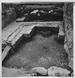
Figure 78: View of the floor of the so-called Republican taberna (AFSRCM, S. Omobono, b. 70, 5, c. 16361.54)
Despite the valuable information provided by our reorganization and study of the archival material and by our observations in the field, many of the most pressing questions about the developmental sequence of the site can only be resolved through careful excavation. As the new fieldwork project continues, the re-contextualization of visible remains has been established as a top priority. Especially for the later phases of sanctuary, which were largely stripped bare in the course of the pre-war clearing of the site, this can be accomplished by focusing on surviving remnants of stratification. Such deposits are still preserved under some of the pedestalled travertine structures pertaining to the imperial redevelopment of the area. With regard to the republican ashlar phases, there is more potential for a fuller stratigraphic reinterpretation. Important new data, for instance, can be obtained by analyzing residual lenses between and underneath undisturbed part of the temple platform and adjoining structures. Furthermore, ashlar features that have been rearranged during one of the many undocumented restoration efforts discussed above could be partially disassembled to clarify their original character.
Thus, the new work at S. Omobono has already revealed tantalizing glimpses of the full complexity and importance of the site—possibly including the presence of undocumented reconstructions of the temple complex. Nevertheless, given the incomplete documentation from past campaigns of fieldwork and the lack of systematic maintenance of the area since its discovery, even a preliminary reinterpretation of its development will have to be delayed until we can fully explore the articulation of nodal structural components through systematic excavation. While leaving many problems unsolved, the fieldwork carried out in 2009 and 2010 has paved the way for the implementation of an integrated and systematic research strategy. Accordingly, upcoming seasons are designed to overcome the particular challenges that have so far impeded any comprehensive and satisfactory archaeological treatment of this unparalleled context. S. Omobono is one of a few sites in Rome that presents an archaeologically accessible sequence spanning nearly the entire history of the city, from the archaic period to the present. We hope that the new research program will fully restore it as an ideal case study for discussions of urban and religious developments.
© Internet Archaeology/Author(s)
University of York legal statements | Terms and Conditions
| File last updated: Mon Mar 12 2012