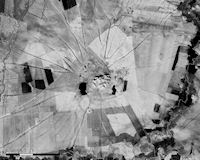
Figure 39: Ancient radial routes or 'hollow ways' surrounding Tell Brak, eastern Syria [CORONA atlas]
One of the best known archaeological applications for CORONA satellite imagery has been in studies of ancient roadways in northern Mesopotamia, often manifested in radial patterns surrounding tells occupied during the 3rd millennium BC (Early Bronze Age). Now commonly referred to as 'hollow ways' following Wilkinson's (1993) terminology, the linear features were first noted by Poidebard (1934) in his pioneering flights over the region, and subsequently documented more thoroughly by van Liere and Lauffray (1954) using aerial photos. Classic patterns of hollow ways form spoke-like radial patterns of linear features, extending up to 5km into fields surrounding mounded tell sites, and while some earlier scholarship questioned their function, recent analysis leaves little doubt that the features are in fact ancient roadways (Wilkinson et al. 2010). The repeated movement of animals and other traffic between settlements and pasturelands, constrained on either side by cultivated fields, resulted in the creation of deep incisions into the landscape. While these pathways eventually infilled with sediments after they were abandoned, the different properties of soil in hollow ways in terms of moisture retention, plant growth, colour, etc. make them clearly visible on CORONA satellite imagery.
Figure 39: Ancient radial routes or 'hollow ways' surrounding Tell Brak, eastern Syria [CORONA atlas]
Investigations by Ur (2003; 2009) show how prominent the features appear on CORONA images, and also explored the various ways in which hollow ways are manifested in images from different seasons and under different land use conditions. Ur's mapping of hollow ways across much of the Syrian Jazireh region shows conclusively how common these features are and that the majority of hollow ways radiate from sites occupied during the 3rd millennium BC, sometimes radiating directly from known gateways in fortification walls as at Tell Brak. A smaller number of hollow ways actually connect Early Bronze Age sites to one another, forming long interregional routes across the steppe.
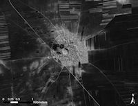
Figure 40: Recently discovered hollow ways at Tell Rifa'at, western Syria [CORONA atlas]
Most analysis of hollow ways has concluded that the features are largely unique to settlements of the Jazireh region during the 3rd millennium BC, as they are not found at sites of earlier or later date in the same area, nor have they been documented at contemporary sites west of the Euphrates River or east of the Tigris. Hollow ways are thought to have formed as a result of a particular set of land use practices that were exclusively characteristic of 3rd millennium BC Jazireh. Yet our own recent analysis now shows that hollow ways may in fact have been more widely distributed in time and space than previously thought (Casana 2012). The availability of CORONA imagery provided by our atlas has facilitated a search for other such features, and we have located several previously undocumented examples, as at the Iron Age settlement of Tell Rifa'at (ancient Arpad), north of Aleppo in the Qoueiq River Valley. The radial features extending across the plain around Rifa'at are identical in form to those found in the Jazireh, yet they are almost certainly Iron Age II in date (c. 1000-700 BC), emanating directly from apparent gateways in the lower town. Another site just 7km to the north-east of Rifa'at, unfortunately as yet unrecorded by archaeologists, also has a fairly well-preserved system of hollow ways surrounding it. The existence of these and other hollow ways outside the Jazireh and associated with sites of later date than the Early Bronze Age suggests that radial routes may be more widespread than has previously been recognised, and by consequence, that the systems of land use which generated them may also have a longer history over a larger geographical zone.
© Internet Archaeology/Author(s)
University of York legal statements | Terms and Conditions
| File last updated: Fri Sept 21 2012