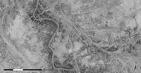
Figure 45: Extraordinarily complex palimpsest of relict canals near Bablyon, southern Iraq [CORONA atlas]
Ancient canals and other watercourses often appear with striking clarity on CORONA imagery, making it an extremely useful tool for discovery, mapping and interpretation of these features. Canals can often be identified as darkened depressions, filled with moist sediments compared to surrounding soils, occasionally bordered by upcast mounds or levees. Unlike natural river channels, man-made canal systems tend to be rather straight features, crossing the landscape.
Figure 45: Extraordinarily complex palimpsest of relict canals near Bablyon, southern Iraq [CORONA atlas]
Some of the most complex and visually stunning canal systems in the ancient world can be found in southern Mesopotamia, where virtually all agriculture depended on irrigation works and where large cities with dense populations have thrived for more than 6000 years. The longevity of settlement in this region and the history of repeated canal construction has left an amazing patchwork of overlapping systems visible at the surface—a classic archaeological palimpsest. The region surrounding the ancient city of Babylon in southern Iraq offers a great example. In this region we can see the modern river and its irrigation works overlying progressively older networks of water management. The development of these systems, from early reliance on splay irrigation along natural river levees through to the massive engineering works of the Parthian and Sassanian periods (Wilkinson 2003) can be traced throughout the CORONA imagery of the area.
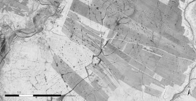
Figure 46: Relict canal systems of late Parthian/Sasanian date (AD 25-640), Khuzistan, southwestern Iran [CORONA atlas]
In areas with shorter-lived irrigation systems, individual systems can be easier to trace. A good example can be seen in the plains of Khuzistan in south-western Iran, much of which was largely dedicated to dry-farmed cereal agriculture through much of its long history of settlement. However, in the Sassanian period (AD 300–640), massive irrigation works were constructed in the region to supply a rapidly growing population and the huge cities in the empire's nearby heartland (Alizadeh et al. 2004). Remains of this phase of intensive canal construction are clearly visible today as rectilinear features crossing parts of the plain. Inspired in part by this very history, the modern Iranian regime instituted a similarly intensive irrigation project in the region during the 1980s, one which has now completely destroyed all traces of the ancient network (Kouchoukos 2001).
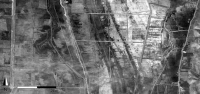
Figure 47: Major canal systems, probably constructed in the Roman period (150 BC-AD 300) in the Orontes River Valley, western Syria [CORONA atlas]
In the Ghab Basin of western Syria, in the Orontes River Valley, massive irrigation or drainage canals can be seen coursing through much of the central plain. The ancient features, which are clearly overlain by the modern and recent historic canal network and field systems built during the early to mid-20th century, are likely originally Roman in origin, judging by the date of numerous sites found along their ancient course (Casana 2003). Up until the 1950s when the modern canal network that now covers the Ghab was constructed, the region was home to extensive seasonal marshlands that inundated much of the valley floor each winter. It is possible that the major canals visible on CORONA imagery, measuring around a kilometre in width, were the result of a similar drainage effort during the Roman period. At least one of these channels seems to have been maintained as a waterway through the marshlands into the medieval period, as such a feature, probably the same one visible in the centre of the Ghab, was described by the Islamic geographer Abu al-Fida during the 14th century AD (Eger 2011).
© Internet Archaeology/Author(s)
University of York legal statements | Terms and Conditions
| File last updated: Fri Sept 21 2012