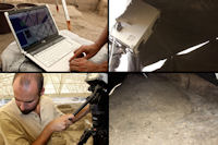
Figure 2: Çatalhöyük, Turkey. Laser scanning of the stratigraphic units/layers detected inside building 86. Archaeological campaign 2010
At our institution, students of an introductory course are expected to be knowledgeable about two main excavation methods used by archaeologists, the arbitrary method per levels and the stratigraphic method. An associated learning outcome with this activity is a student solving ill-defined problems, which is characteristic of the high-order thinking in the field. From our experience, students have problems with some crucial passages of the stratigraphic method. When looking at a 2D profile or picture paired with lecture notes, students struggle to identify the relationships between each layer in the profile, and subsequently identify the relative chronology and create the matrix of the stratigraphy, based on Harris' law of superposition (Harris 1989). In particular, students struggle to identify a pit and its relationship with the layers that were cut to create the pit.

Figure 2: Çatalhöyük, Turkey. Laser scanning of the stratigraphic units/layers detected inside building 86. Archaeological campaign 2010
The application 3D Virtual Dig (3VD) was grounded on the premises discussed above and realised thanks to a multidisciplinary collaboration between two archaeologists and a computer scientist. 3VD is the first educational application that simulates an archaeological excavation process in 3D. Unlike the other virtual applications available for teaching archaeology, 3VD reproduces a real archaeological excavation area in three dimensions. Students can work on the 3D reproduction of the stratigraphic units excavated in a mud-brick house at Çatalhöyük, Building 86 (Forte et al. 2010, 20-3). The excavation area was laser scanned, with highly accurate 3D digital representations that are readily shared, indefinitely reproducible, and cheaply and efficiently stored (Figure 2). This approach favours the preservation and data storage of a very detailed 3D reproduction of the layers that would otherwise be impossible, considering the destructive nature of the archaeological excavation process (Figure 3). 3VD is a real-time application designed for classroom use, to test the individual capacity of students to interact with a 3D representation of the archaeological context and determine the chronological relationships between units of an excavation area. Therefore, 3VD was not conceived for a collaborative environment (e.g. Forte 2008; Forte et al. 2010) and/or a web-delivered application.

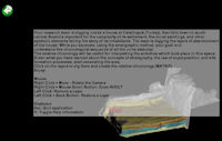
Figure 4: 3D Virtual Dig. Introductory window providing the users with instructions on how to use the application and a brief introduction on the archaeological site of Çatalhöyük
When the application starts, a window appears with information about the archaeological site and instructions on how to use the application (Figure 4). To make the simulation activity and the recognition of the units easy, we chose not to add texture to the units. We assigned each unit a distinct colour; the goal of this activity was to stress the importance of the volumetric reproduction of the layers, and to enhance students' understanding of the layers' physical relationships, that is, of the law of superposition.

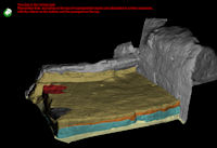
Figure 5: 3D Virtual Dig. Red colour texts explaining why the user was not able to recognise the exact unit

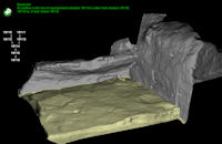
Figure 6: 3D Virtual Dig. Green text showing the user that the right unit was recognised and, therefore, virtually excavated
In the application students are asked to use the mouse to excavate layers in the right order (see Screencast). Every time a student fails the task, red colour text appears on the screen and reminds them of the law of superposition (Figure 5). Each time the students are able to virtually excavate a unit, green colour text confirms that the task has been accomplished, while on the left side of the screen, the matrix of the excavation area starts to be created (Figure 6).
Unlike Virtual Dig, 3VD is not intended to teach how to organise and run fieldwork in lower-division classes. 3VD focuses on the excavation process and stratigraphic method. In this sense, the aims of this application are closer to that of Excavating Occaneechi Town. From these premises it is clear that by interacting with a 3D reconstructed area, instead of a 2D picture, students can more easily understand the steps of an activity that is mainly material and three-dimensional.
© Internet Archaeology/Author(s)
University of York legal statements | Terms and Conditions
| File last updated: Wed Dec 12 2012