Viewshed from the Stonehenge Avenue where it crosses King Barrow Ridge
Cite this as: Pitts, M. 2002 Stonehenge Landscapes and Stone Circles: A combined review by Mike Pitts, Internet Archaeology 11. https://doi.org/10.11141/ia.11.7
Stonehenge Landscapes: Journeys through real-and-imagined worlds by Sally Exon, Vince Gaffney, Ann Woodward and Ron Yorston. Published by Archaeopress. ISBN 0953992306. �39.00 for book + CD with single-user licence. Contact Archaeopress, Gordon House, 276 Banbury Rd, Oxford OX2 7ED. Email: [email protected]
Stone Circles: A Photographic Tour by Tom Bullock. �20 plus delivery from www.megalithic.co.uk. Email: [email protected]
Archaeologists agonise about using the experience of people living in the present to help them think about people's lives in the past. Beneath the rhetoric, however, lies the simple fact that if you study the work of anthropologists, you are confronted with real individuals and communities. The practise of learning from such communities can be particularly liberating if you mix with them yourself, as I learnt when writing a book about Stonehenge (Pitts 2001).
The most inspiring thing I read researching Hengeworld was a still controversial paper by Mike Parker Pearson and Ramilisonina (1998). Fresh from Madagascar (quite literally in Ramil's case, who had been flown over to an icy Wiltshire by the BBC), they were inspired to see Stonehenge as a living construction in a world of people and ancestors. Anyone familiar with Stonehenge literature will know how different this was from the more usual fare, that too often conjures with lichen-covered megaliths encircled by the spirits of brown-coloured, broken artefacts and dead archaeologists.
The dedicated Stonehenge researcher might have noticed that in adopting Mike and Ramil's basic thesis - Stonehenge as a place for ancestors, Woodhenge for people, stone dead, wood alive - I ignored some of the ancillary arguments (their case for the symbolic significance of pottery filler I found particularly unconvincing) and stretched others. But what I most liked was the way in which their ideas linked scattered sites and monuments in a real landscape rich with meaning. Even if their thesis was 'wrong', I felt, this was too positive a vision to hide from the general public.
I write this sitting amongst one of the grander clusters of Bronze Age barrows at Stonehenge, on King Barrow Ridge. It's been very wet, but for the moment the sky is an icy blue, and a cold wind rattles the twigs and buffets the rooks high in the beeches. The last time I was here, I had with me a copy of Parker Pearson and Ramilisonina's paper. Now, on the hard drive of my laptop projecting a map that peaks out from behind this text file, is Stonehenge Landscapes. I am experiencing a return of the thrill I felt before. Let me explain.
Parker Pearson and Ramilisonina took from Madagascar an association between the substance of stone and the world of ancestors, and with wood and the living. Stonehenge, with its huge sarsens carved and slotted together as if they were timbers, came to life in this reflected light. With Woodhenge 3km to the north-east, and an easily pictured route linking the two along the winding River Avon and the chalk-cut Stonehenge Avenue, the Neolithic landscape introduced a strong topographic component to the model.
Risking accusations of whimsy, I expanded on this theme by pointing out that Woodhenge was to the east - the living where the sun rises - and Stonehenge to the west, where not only the sun sets but, over the horizon, was the distant source of the bluestones, which I suggested might then be envisaged as an embodiment of the land of the ancestors expressed in the living landscape. The famous midsummer alignment (of both Woodhenge and Stonehenge) indicates the rising and setting sun at their closest points on the horizon, a symbolic juxtaposition, I proposed, of the new-born and the ancestors.
Having devised this theory, I went to Woodhenge and attempted to walk the route to Stonehenge. This took me to places never seen by tourists and, I suspect, rarely by archaeologists - the swirling, muddy water of the Avon cutting a steep bank below Durrington Walls, the waterworks at Ratfyn, people feeding ducks over the Avon near Amesbury church, and so on. In other words, it was a journey through the modern landscape, and like most of contemporary England, there were several places I couldn't legitimately enter. Of course restricted access is more than likely to have been a feature also of the Neolithic landscape, but the rationale and positioning are equally likely to have been quite different.
This time I have not a muddy photocopy of a set text, but a coloured topographic animation on my iBook (to really get the wind up opponents of 'ethnographic analogies', I could plug in some earphones and listen to Madagascar - on this island in 1989 I acquired a passion for the richly multicultural music, not shared, it must be said, by Mike Parker Pearson). I see things I had not seen before.
Viewshed from the Stonehenge Avenue where it crosses King Barrow Ridge
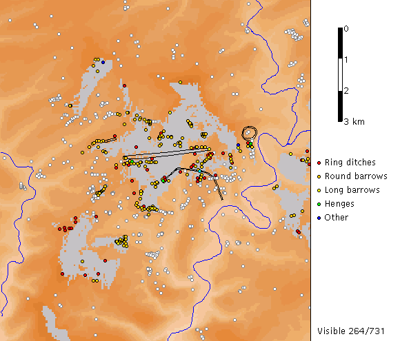
The base map covers a slightly larger area than that of previous Stonehenge studies (substantially larger in the case of the 1979 Royal Commission map), about 100 square kilometres. It comes up with height bands coloured by varying shades of orange, but I can change this to a more 'realistic' range of greens. Ring-ditches, round barrows, long barrows and henges are marked by small white circles, major earthworks appear as black lines and the Rivers Avon and Till flow down either side.
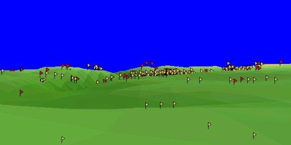
Example of an Applet-based 3D landscape view derived from the digital elevation model. Colour coded flags mark archaeological monuments. The scene can be adjusted by dragging the mouse over the landscape, and an accompanying map shows view lines. The viewpoint can be selected by clicking on the map, and angle of field, direction etc can be controlled from the buttons. Getting it to work takes a bit of practice (the landscape had a tendancy to turn inside out on me), and I had to shrink both windows to view them simultaneously, but this is a powerful (and fun) tool.
On this particular 'applet', an animation has been set up in which a little green spot moves back and forth along the route of the Stonehenge Avenue. As it does so, constantly changing 'viewsheds' from the spot are mapped in grey, and those of the 731 earthworks on the map that become visible are selected in their appropriate coded colour.
A 'least-energy' route between Stonehenge and the river has been computed, and this line can be selected instead of the Avenue. So I can compare what can be seen - assuming bare downland - from these two routes in ways quite impossible by walking around the fields and roads. The patterns suggest that sight-lines were instrumental in the selection of the Avenue route, and in ways that can be well accommodated within the model described above.
The shorter least-energy route zigzags from east to west, with no particularly strong viewshed patterns apparent. Henges - of which there are six, including Stonehenge - might be thought particularly significant. Durrington Walls can never be seen, and following the least-effort path neither can any of the others for nearly the first kilometre. Then there is a glimpse of Woodhenge; Coneybury, Winterbourne Stoke and Stonehenge come into view, soon followed by a couple of quick flashes of Fargo Plantation. We lose Coneybury, then Winterbourne Stoke goes and Fargo comes back and stays. For a brief period they all vanish, then Stonehenge is reached, from where the only other henge site visible is at Fargo Plantation.
The story is quite different when we take the longer Avenue route. Almost immediately, Woodhenge comes into view, and stays there until we reach King Barrow Ridge. From here, for a brief stretch, we can see all the henges except for Coneybury. As we continue down the other side of the ridge, only Stonehenge remains in sight, and for the second half of the journey this becomes the sole visible henge. Only as we approach close to the stones do they disappear, and then dramatically re-appear as we climb the hill. The one exception to this tripartite henge scenery - from views of Woodhenge to Stonehenge, with all but one visible at the point of change-over - is a sudden glimpse of Coneybury as we climb up from the River Avon, the only sight of this henge.
A similar comparison can be made between the muddled picture of viewsheds from the least-effort route, and the more structured viewsheds from the Avenue. As we move along this earthwork from the river, landscape views shift systematically from south-eastern, through eastern, to north and east, and so on around the compass until on King Barrow Ridge we are looking west. The views close in as we descend into Stonehenge Bottom, opening up for a full panorama at the stones.
Given that we begin in a river valley with an intervening ridge to the west, any route from the Avon to Stonehenge is going to have a shift in viewsheds from east at the start to west later. But the systematic change in view directions seen along the Avenue does not occur on the least-effort route. This begins with views to the south-east, then opens up for wide views all around before changing to predominantly westward views, and then, as on the Avenue, to restricted viewsheds to north and to south. The strong sense that on the Avenue route you are being encouraged to see the landscape with a steady anti-clockwise sweep from east to west - mirroring the daily passage of the sun in the sky - is absent. The significance of the transitional zone on King Barrow Ridge may have been perpetuated in the placing of later round barrows: along the Avenue, there are only two places (a counter in the corner of the map tells me) where over 200 barrows can be seen: from Stonehenge, and from King Barrow Ridge.
The point of all this, of course, is that the structuring of views forced by the route selected for the Stonehenge Avenue, with Woodhenge visible for the first half and Stonehenge for the second, fits very well the hypothesis that the Neolithic perception of the landscape was determined by a physical or symbolic journey from Woodhenge and the eastern horizon, to Stonehenge and the western.
I am not aware that anyone has noticed this before. It took this marvellous study by Exon, Gaffney, Woodward and Yorston - we are, you may remember, reviewing a book - to reveal it. But this is only beginning to tap the potential of the CD. The book is a substantial text that explores the development of the landscape from Mesolithic to Early Bronze Age, an original and valuable contribution in its own right. But I have intentionally focused here on the interactive element, a uniquely novel contribution to the huge literature about Stonehenge. The CD contains the entire text and 80 or so illustrations from the book. Maps and animations are set up, but the database allows you to explore hypotheses that leave the authors' original interests further behind than I have in this example. As well as viewshed animations, there are digitised 3-D landscape views and photographic panoramas with spoken commentaries. If I wasn't already sitting on a barrow as I write, I could run these files and readily imagine myself in the Stonehenge landscape.
Stone Circles: A Photographic Tour is altogether different. It starts well. When I open up the Stonehenge Landscapes CD, I am presented with a bewildering selection of files with no guidance as to what to do (I found index.htm a good entry, via Internet Explorer; otherwise, the CD instructions are comprehensive). Stone Circles, on the other hand, gives me a 'Stone Circles' icon, which takes me straight to a photo of Avebury with clearly labelled buttons. 'Go to the Intro' leads me through a succession of photos to some text that congratulates me for acquiring 'the first electronic encyclopaedia devoted exclusively to the subject of the Stone Circles and Rows of the British Isles'.
This is, I read, a collection of captioned photos. You can access them through a map, either by clicking on grid squares or directly by entering a name. 'Avebury' brings up a moonlit view, with the information that 'Ambience' is 'Excellent' and 'The site is vast and complex'. Another point of entry is a listing of megalithic sites. From here you can see which circles the author has not yet visited, and when he did visit those pictured on the CD.
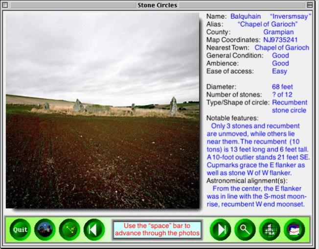
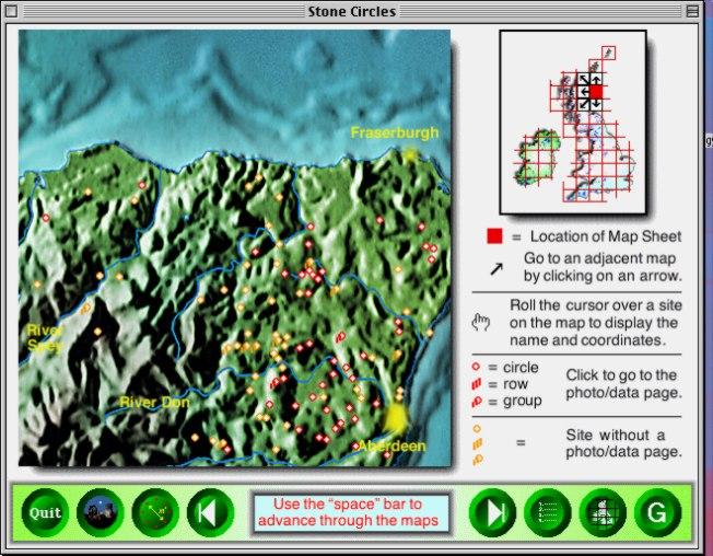
Screen for Balquhain (left), found via the map square. Aubrey Burl's description of this site (in The Stone Circles of Britain, Ireland and Brittany, Yale University Press 2000, 149) has more archaeological information and a detailed bibliography, but for a site visit, the CD is more useful, if not yet everything you need to avoid getting lost. Example of an index map square (right), from which site entries can be selected.
If you want an idea of what a site you are reading about elsewhere looks like, or you need reminding of what you saw on your own visit, this is a useful tool. But that's about all it will do for you. It is in effect a well-indexed book of photos, cheaply produced on a CD. Stonehenge Landscapes, on the other hand, looks like a book, but is actually a highly interactive electronic database. It seems we haven't quite got this format business right yet.
Pitts, M, 2001. Hengeworld. London: Arrow.
Parker Pearson, M, and Ramilisonina, 1998 'Stonehenge for the ancestors: the stones pass on the message'. Antiquity 72, 308-26.
Mike Pitts
125 High St
Marlborough
SN8 1LU
Email: [email protected]